Article
BROWNFIELD IN THE ENTRANCE OF THE TOWN OF KENADSA: AN INDUSTRIAL HERITAGE, DIFFICULT TO ASSUME
DESERTO INDUSTRIAL NA ENTRADA DA CIDADE DE KENADSA: PATRIMÔNIO INDUSTRIAL DIFÍCIL DE ASSUMIR
BROWNFIELD IN THE ENTRANCE OF THE TOWN OF KENADSA: AN INDUSTRIAL HERITAGE, DIFFICULT TO ASSUME
Arquitetura Revista, vol. 15, no. 2, pp. 388-407, 2019
Unisinos
Received: 01 June 2018
Accepted: 05 February 2019
Abstract: Kenadsa, the first industrial city in the south of Algeria during the colonial era, experienced intensive production of the coal deposit. After the independence of Algeria, in 1962, the mining activity, which had ceased to operate by a governmental decision, left behind it a huge industrial emblem. This one is today classified as a cultural and historical heritage in Bechar province. However, land and buildings left vacant by industry are located in the middle of the city of Kenadsa, where a relatively high population density is centred. This configuration suggests that both the town and its inhabitants are confronted to a serious risk of soil and air pollution. The brownfield of Kenadsa, which is situated in the entry of the town, embodies the identity as well as the history of the city. In the hope of reducing the abandoned industrial spaces, this paper proposes forms of land use planning that pave the way for the evolution of the town in question. Therefore, a historical approach that places the phenomenon in its space and time framework is adopted. This approach is followed by an impact study that is accompanied by a survey of some notabilities. Finally, this paper suggests ways to preserve cautiously the traces of an industrial past that, at the same time, poses constraints to urban planning and harms the urban landscape and the environment.
Keywords: Brownfield, Kenadsa, coal, cultural heritage.
Resumo: Kenadsa, a primeira cidade industrial no sul da Argélia durante a era colonial, experimentou a produção intensiva do depósito de carvão. Após a independência da Argélia, em 1962, a atividade de mineração, que deixou de operar por decisão do governo, deixou para trás um enorme emblema industrial. Este é hoje classificado como patrimônio cultural e histórico na cidade de Bechar. No entanto, terrenos e edifícios deixados vagos pela indústria estão localizados no meio da cidade de Kenadsa, onde uma densidade populacional relativamente alta é centrada. Essa configuração sugere que tanto a cidade como seus habitantes são confrontados com um sério risco de poluição do solo e do ar. O brownfield do Kenadsa, situado em sua entrada, incorpora a identidade e a história da cidade. Na esperança de reduzir os espaços industriais abandonados, este artigo propõe formas de planejamento do uso da terra que pavimentam o caminho para a evolução da cidade em questão. Portanto, adota-se uma abordagem histórica que coloca o fenômeno em sua estrutura de espaço e tempo. Essa abordagem é seguida por um estudo de impacto que é acompanhado por um levantamento de algumas notabilidades. Finalmente, este artigo sugere maneiras de preservar cautelosamente os traços de um passado industrial que, ao mesmo tempo, impõe restrições ao planejamento urbano e prejudica a paisagem urbana e o meio ambiente.
Palavras-chave: Brownfield, Kenadsa, carvão, patrimônio cultural.
LOCATION OF KENADSA
Kenadsa, an oasis in the south-west of Algeria, is located 18 km from Bechar province. It is bordered to the north by the first Barga, to the south by Chebka Mennouna, to the west, by the area of the wadi Messouar and to the east, by the region of Bechar. Administratively, Kenadsa is a town with an area of 5,040 km2, housing a population of 14,630 inhabitants (Figure 1).
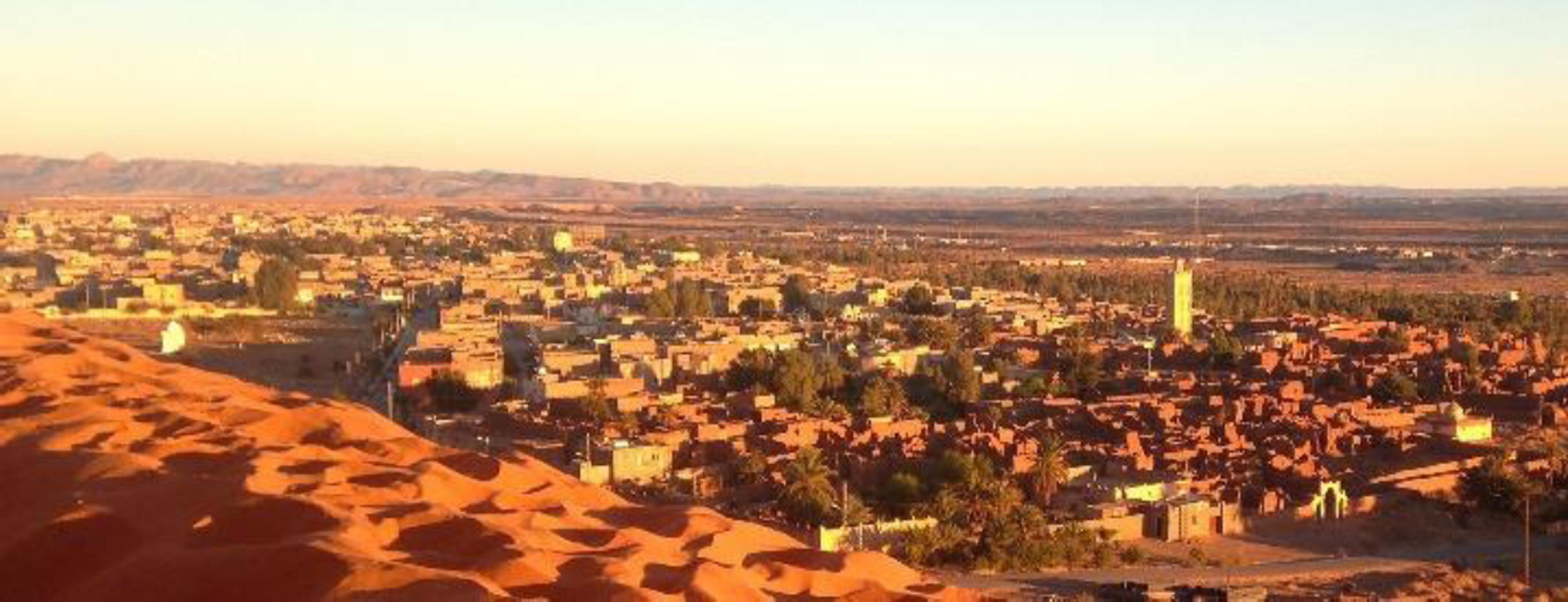
Figure 1
View of Kenadsa City.
(https://www.skvscrapercity.com/showthread.php?t=2139062. recovered on April 10, 2017)
Kenadsa was a great quiet oasis in the middle of a great desert. When the French arrived and discovered coal in its basement, they started to exploit it, an activity that had profound consequences (Figure 2).

Figure 2
Situation of Kenadsa.
(http://www.carte-algerie.com/carte-algerienne.html, recovered on March 14, 2018)
RESEARCH OBJECTIVES
The geological study was carried out in 2003 by the national office of geological and mining research of Algeria. A study to deal with coal dumps in the community of Kenadsa is the result of a growing realization of the need for environmental protection. This study includes analyzing the general physical setting of the Carboniferous Basin, slag heaps supported by the study and the surrounding environment.
In order to know the physical and chemical nature of the composition of the spoil tips under study and know their impact on the surrounding environment (population, fauna, flora, groundwater, air), it was necessary to take rock samples on slag heaps and water through existing pits in the area.
Beyond the simple reading of the existing documents, an investigation into the daily life of the city dwellers, local authorities and professionals, such as mining responsible, architects, local librarians and historians, seems to be the appropriate method to have reliable information regarding the existence of Kenadsa's brownfield at the entrance of the city (Figure 3). So, interviewing this category of people is of a great significance to this study.
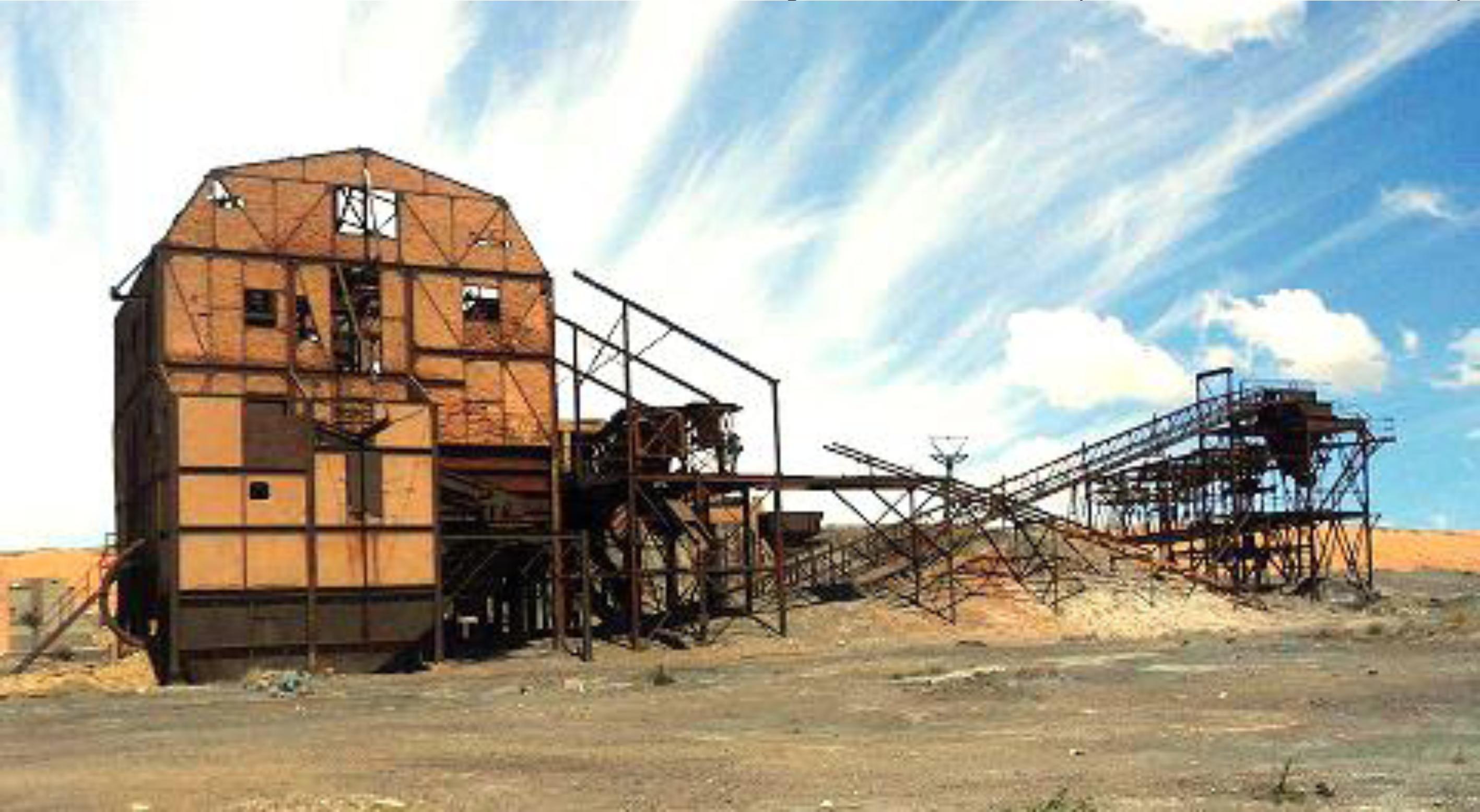
Figure 3
Brownfield (wash-house in Kenadsa).
Our objective is, therefore, to recognize the exact perception of the interviewers with respect to the current place of the brownfields. The question that one may ask is: What future is proposed for the brownfield of Kenadsa?
Finally, in order to make profitable the abandoned industrial spaces, which are a burden for the managers, this paper proposes forms of development of the territory that enable Kenadsa to become a viable town. Therefore, a historical approach situating the case under study in space and time is adopted. An impact study will then be applied, including a survey with some notabilities. To conclude, we will suggest a proposal that can manage the traces of an industrial past without imposing any kind of constraint on urban planning, nor harming the urban landscape and the environment.
THE INDUSTRIAL WASTELAND, OR THE BROWNFIELDS
They represent an extremely varied heritage of plenty of the fields of industry (metallurgy, petrochemistry, steel, textile, chemistry), agri-food, etc. The built structure may prove to be particularly complex (surface and underground), and soil pollution can be very high.
Brownfields are more referred to “previously developed lands” than “contaminated sites” in the United Kingdom (UK) and are accepted as all abounded, idled, or underused properties with fixed infrastructure and developed surface on site regardless of whether contamination is present or not (Mehdipour et al, 2013, p. 80).
Yet, the term “brownfield” denotes an urban industrial site that has been abandoned and where its reuse or redevelopment is not an easy task.
A BRIEF HISTORY OF MINING EXPLOITATION IN KENADSA
With the settlement of the French colonists, in 1903, Kenadsa was still a prosperous cultural centre: its zaouia “monastery”, spread on a territory that could exceed a thousand kilometres in the round, had its ramifications throughout the northern Maghreb (Figure 4).

Figure 4
View on ancient Ksar of Kenadsa.
(https://www.vitaminedz.com/afrique-algerie-kenadsa-vuegenerale/Photos_20155_170369_8_1.html. recovered on January 11, 2017)
Kenadsa also played a pivotal role as a crossroad between North and Sub-Saharan Africa. By the considerable number of pilgrims flocking to its zaouia, it was also called “small Mecca”. Moreover, merchants who practised trade of all kinds could not cross their territory without a stopover at the zaouia and especially without a visit to the mausoleum of the patron saint of the city to solicit his benediction for their own person, for their children and their families and to seek the protection of their trade (Azizi, 2016, p. 23).
The French colonialism exercised pressure on “the zaouia of Kenadsa.” It prohibited “the zaouia” to have relations with its affiliates, and to collect money from financial contributions that ensued from the ziarats “religious visits” (Azizi, 2016, p. 28). After the Algerian Independence, in 1962, the ancient traditions and religious practices were restored through popular and religious festivals.
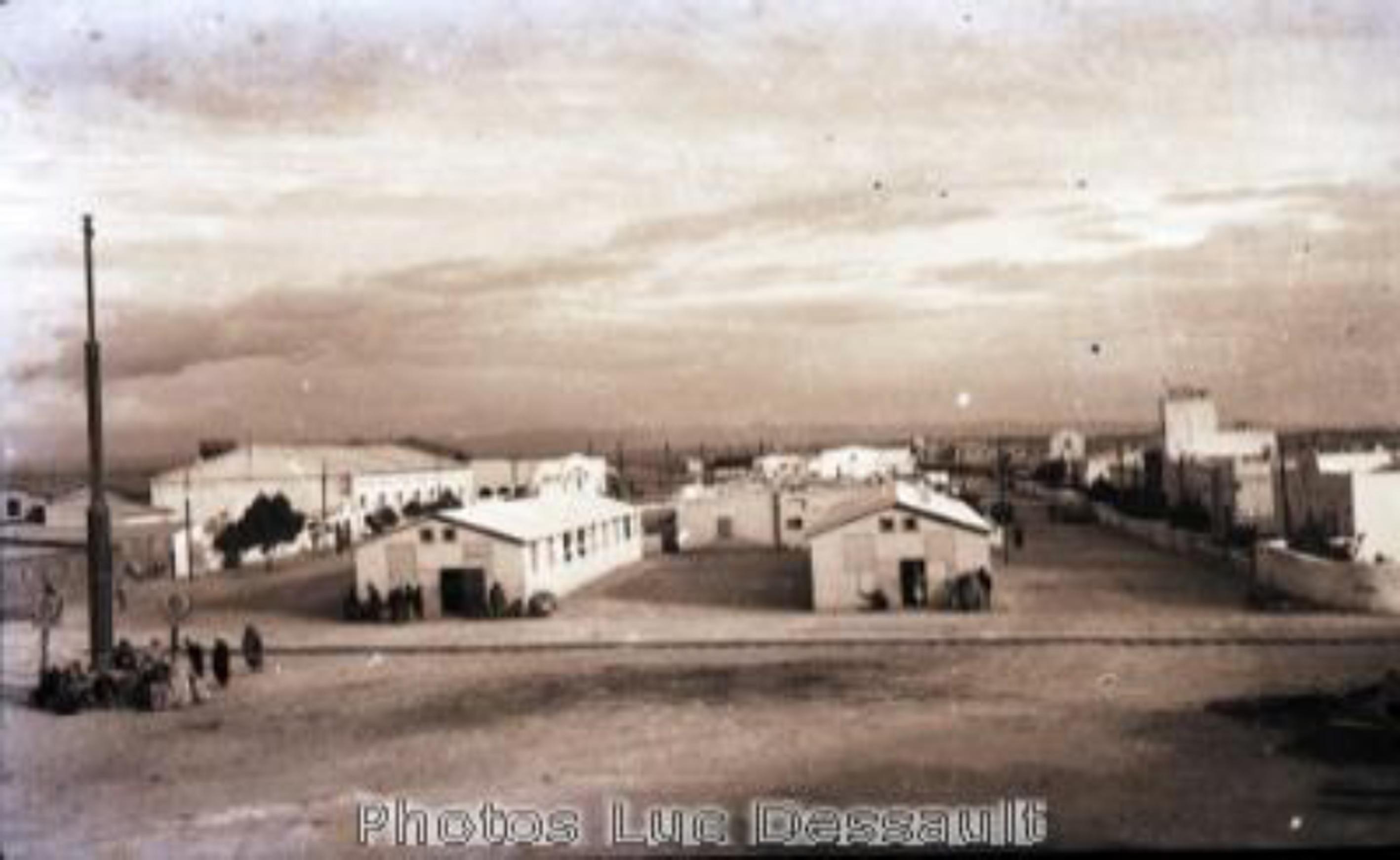
Despite the fact that the French employed different means to undermine the pecuniary sources of the local inhabitants, Kenadsa underwent an unexpected renaissance. A new deal was to give it a second historical breath: the discovery of coal. Kenadsa experienced a new economic boom that added another dimension to the spiritual character of the town. This new development served the colonial investors (Figure 5). This change had transformed the spiritual city into an industrial pole for the whole region of the south west of Algeria and even further geographically (Azizi, 2016, p. 28).
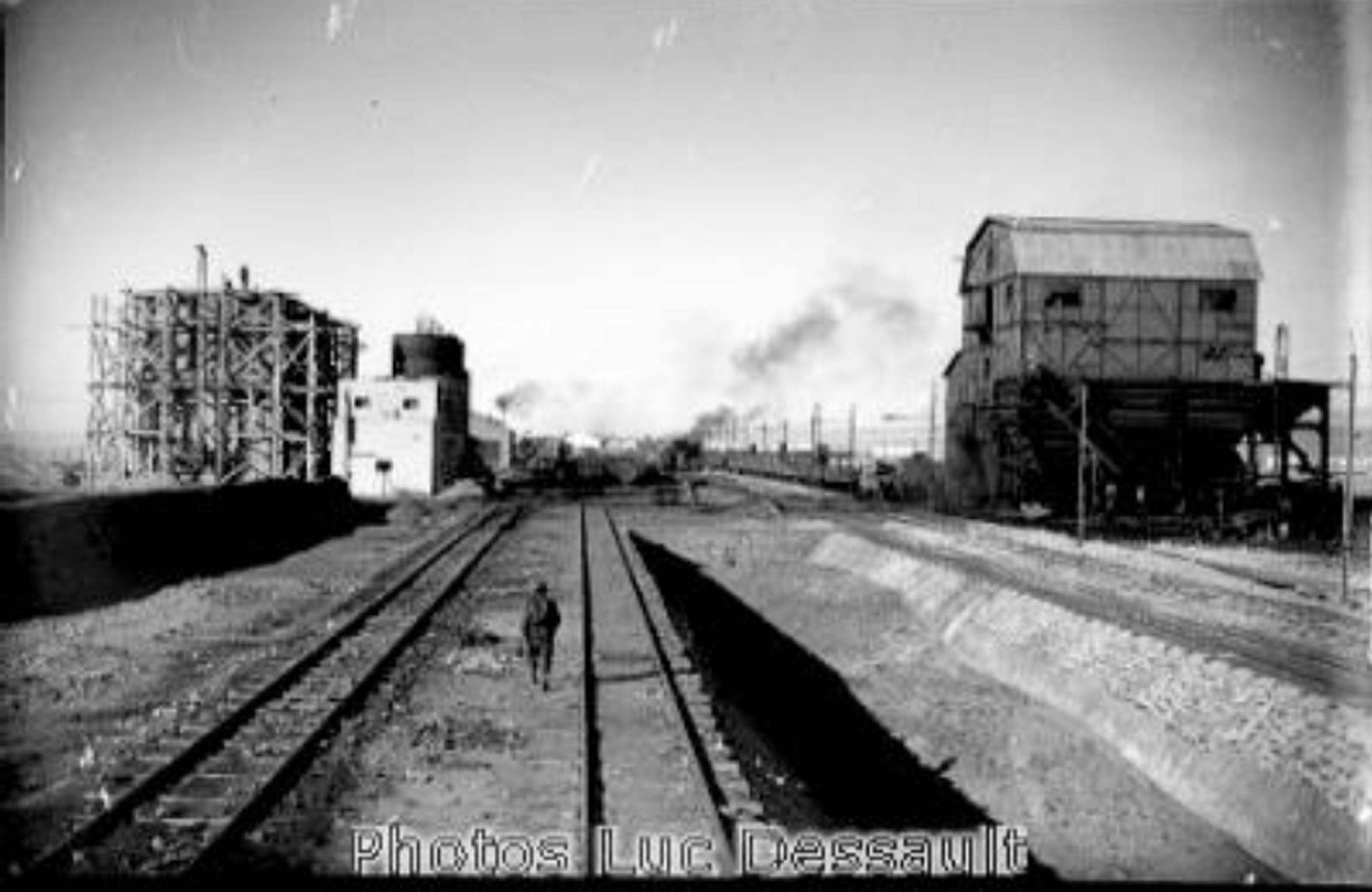
Figure 5
View of the colliery of Kenadsa.
(http://www.algeríephotopro.com/kenadza.htm, recovered on January 11, 2017)
The exploitation of coal mines by a company known as Houillères du Sud Oranais (collieries of south oranais) from 1917, and the arrival of the Oran railway line to Kenadsa with various ramifications to Morocco and the rest of Algeria, brought significant changes to the area: shifting from a quiet and peaceful town, where meditation reigned, into an animated one, where the noise of machines and the building of the infrastructures soon took precedence over any other consideration (Figure 6).
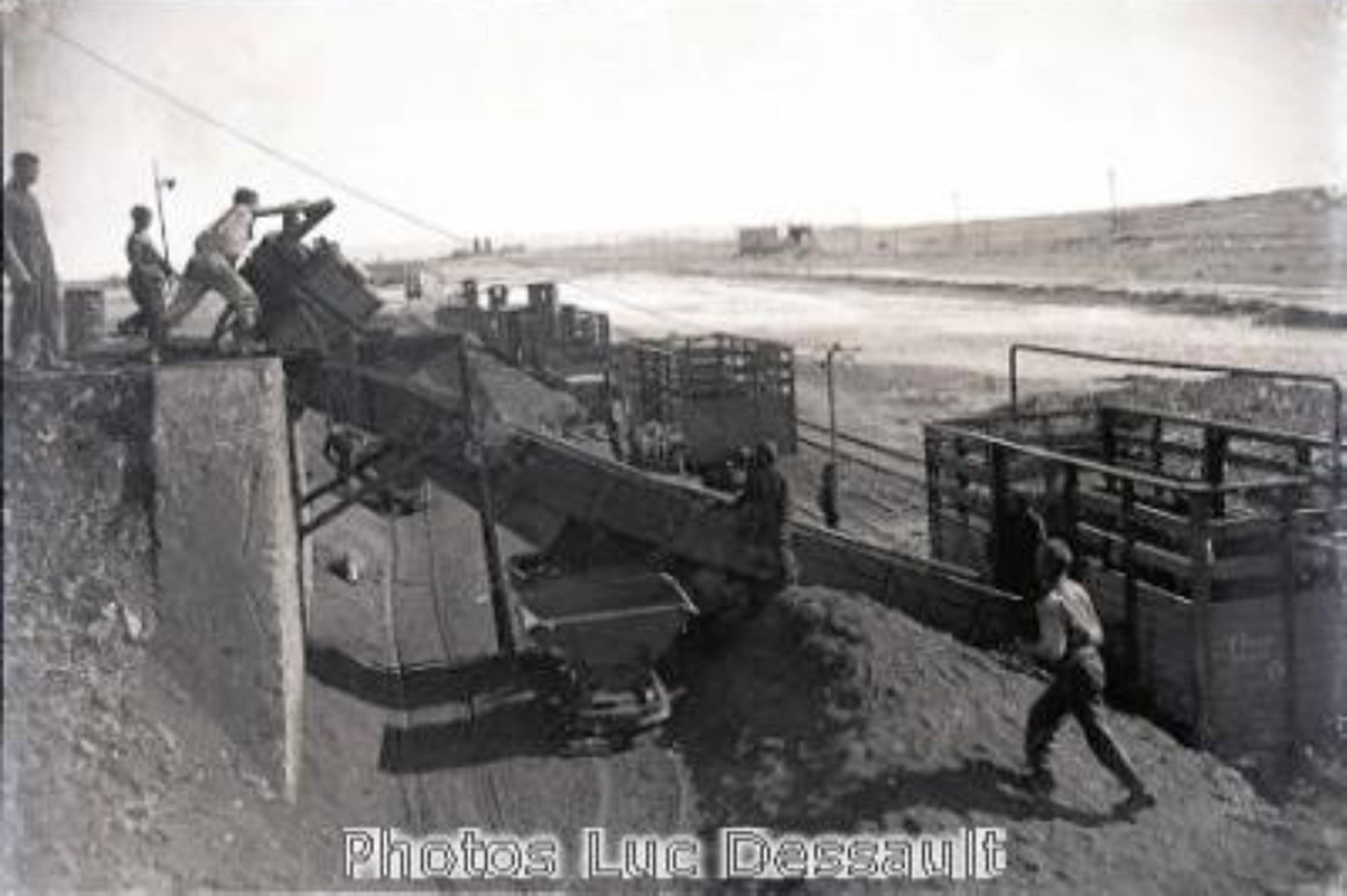
Figure 6
Transport and sorting of coal.
(http://www.algeriephotopro.com/kenadza.htm, recovered on January 11, 2017)
In this configuration, the call to prayer in concomitance with the noise of sirens, announced the beginning and cessation of work in the workshops and offices of the Company. It is the osmosis of modernity and tradition that had no equivalent in the Sahara.
A new, but modern city was built next to the ancient “Ksar” (fortified village) and a very diverse workforce came in from all sides. In a very short time, a heterogeneous and cosmopolitan population was formed. There was, on one side, the European city where French, Spaniards, Italians, Maltese, Corsicans, Dutch, Germans, Greeks, and so on, lived. In other words, only the professional elite and technical staff of the mine had access to this agglomeration, including engineers, “masters” and foremen, chiefs and subchiefs, and, finally, all the European leaders of the mine (Figure 7).
On the other side, to the west, the Arab city was located. New constructions were added to the old Ksar.
Consequently, new districts emerged in the extreme east and the New Ksar, in the south. They were “Houses” built in a hurry to house the cohort of miners. Maghrebians flocked from all over North Africa, including Algerians and Moroccans. There were also many Berbers, “an ethnic group indigenous to North Africa” who had the advantage over others of fluent French, but mostly had experience in working in the mines because of their former emigration to the north of France. Some simply came from the mines of Northern Algeria.
This new activity created multiple business activities: new trades and small trades. Besides, new habits of consumption were established. In this area, storehouses were opened to the minors, who were allowed to buy on credit everything they need. This extends to clothes, food and appliances of the time. Of course, this had influenced the way of life of the local population, whose traditional coat was replaced by the European costume. Moreover, bars and restaurants of modern conception overwhelmed the traditional locality.
The French schools, on the other hand, welcomed the children of the Europeans only, but, in the 1950s, they started to receive the sons and daughters of the natives (Azizi, 2016, p. 29).
At this juncture, it is necessary to mention that the coal mining process began in 1918 and expanded intensively between 1942 and 1960 (Figure 8).
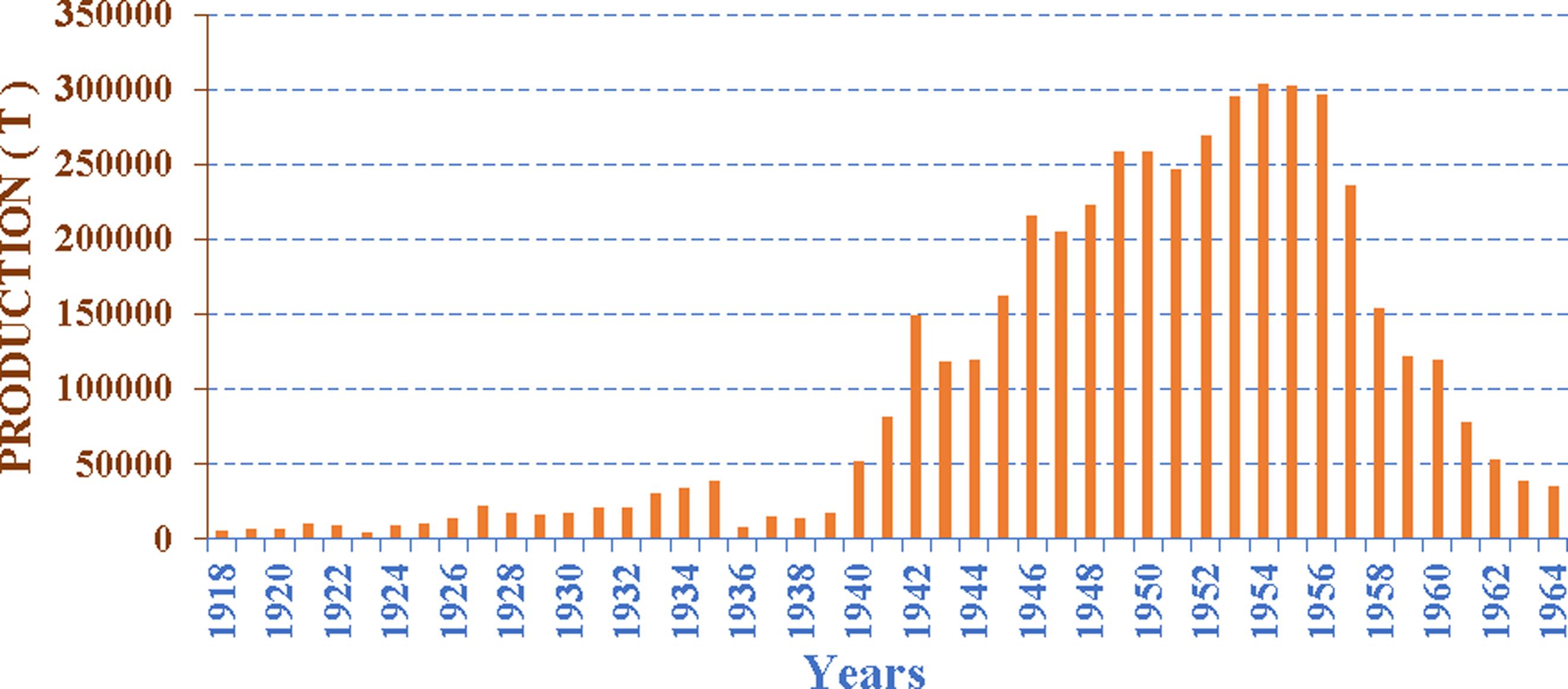
Production continued at the wake of the Algerian independence, in “1962”, at a rate of 10,000 tonnes/year, mainly following the nationalisation of hydrocarbons, in 1971. Nevertheless, this industrial activity was shut-down by governmental decision in 1975 for financial consideration. The Algerian company considers the mining extraction as a costly and dangerous operation. It requires huge sums of money and can cause fatal accidents. (O.N.R.G.M, 2003, p. 08)
The reserves of coal would be about 100 million tons, to a depth of 400m (O.N.R.G.M, 2003, p. 10). The work carried out made it possible to estimate the current reserves as follows:
The coal reserves that can be used in Kenadsa are:
-
– 10.93 million probable tons.
-
– 7.71 million tons possible.
-
– That is a total of 18.64 million tons.
BIRTH OF SPOIL TIPS
The ore and the cask felled in the gallery were stored on the surface. After manual sorting, the coal was then transported to the laundromat at the east exit of the town of Kenadsa.
Another quantity was destined for the production of electrical energy at the thermal power station of Bechar-El Djedid (another locality in Bechar province). The conveyance of coal from the sites to the processing or export facilities was done through a narrow railway network.
Over the years, the flat morphology of the lands (flat cover) and their very low occupancy rate, have been created and multiplied at the exploitation sites (Figure 9), the laundry at Kenadsa and the power station of Bechar El-Djedid. The latter was well isolated from populations and dwellings.

CURRENT STATE OF THE HEAPS AND THEIR NEIGHBORHOOD
After the definitive closure of coal mining, in 1975, for economic considerations (high costs; low reserves), the development programmes that succeeded still included a budget for the industrialization of the region and for encouraging agriculture to meet the region's needs and to overcome the unemployment crisis that affects an increasingly large population (O.N.R.G.M, 2003, p. 18).
This industrialization has caused a significant rural exodus to the capital of the province, which has led to several problems, including labour ones, and, in particular, housing problems, resulting in the sometimes-anarchic development of urbanization in the city.
The extension of housing estates built before the 1970s was such that it spilled over into areas very close to the dumps and sometimes even into the dumps. Furthermore, the illegal occupation of the mining infrastructures, as well as the urbanization of the area ensuing from the housing crisis, create a real problem to the slag heaps. The latter were surrounded by an anarchic urbanization, which does not respond to the urban criteria (Figure 10).
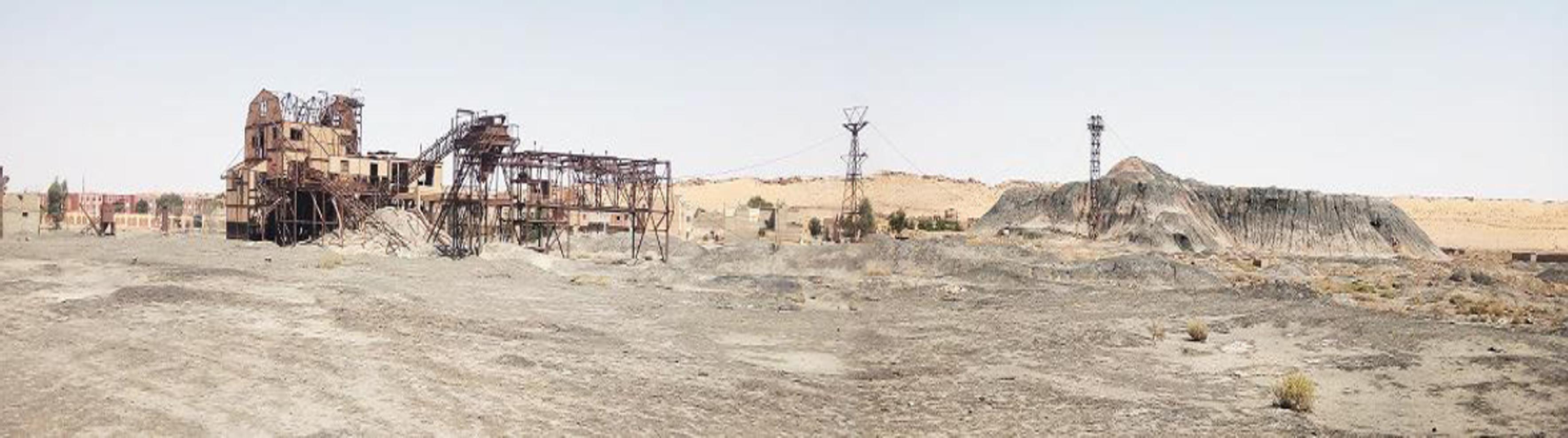
Figure 10
View on Brownfield of Kenadsa (wash-house and spoil tips)
The volume of heaps located at more than 800 m of agglomerations amounts to 1.450.000 m3, for an area of 70.5 ha. The overall volume of the Bechar-Kenadsa pond is estimated at 3.55 million m3, or 7.81 million tons, for an area of about 110.9 ha (O.N.R.G.M, 2003, p. 27).
THE IMPACT OF THE SPOIL TIPS ON THE ENVIRONMENT OF KENADSA CITY AFTER THE STOPPAGE OF THE MINING OF COAL
The degradation of land is among the worst effects of the mining industry on the environment (O.N.R.G.M, 2003, p. 98).
“Mines not only create direct and indirect employment opportunities but also generate foreign exchange earnings and tax revenues” (Das and Mishra, 2015, p. 84). Although industry has a direct impact on the rise of economy, it has negative effects on the environment and human beings. The study of the impact of Spoil tips on the environment of the city of Kenadsa is obviously an essential operation to carry out.
It is reflected, in particular, by the assessment of the effects of possible discharges by the spoil tips in the region of non-recyclable and destructive pollutant compounds from natural ecosystems. These effects include social disruption and dislocation, relocation and resettlement, and adverse impacts on heritage and livelihoods (Danielson, 2006, p.19).
The city's urban surge in recent years has been carried out without taking into account the real data of the mine site and its easements (mining galleries, spoil tips, laundry). Currently, spoil tips are an integral part of the new urban sites of the city of Kenadsa.
Risks of nuisance
Coal spoil tips are generally composed of native elements, such as sulphur, sulphides, sulphates, halides, carbonates, oxides, and hydroxides. While the other constituents are organic compounds.
All of the following components: barite, halides, carbonates, siderite and dolomite may constitute a potential risk of pollution for both air and water near coal dumps. They can also provoke harmful and pathological effects on health when they are well identified by methods which make it possible to bring them back to their cause. The effects of pollutants on health are linked to many factors, which relate to the points of impact that depend on the ability of the organism to reach the disease, its nature and level of concentration in the environment, and the degree of sensitivity of the exposed organism (O.N.R.G.M, 2003, p. 101,102).
The effect of spoil tips on the environment
The spoil tips of Kenadsa are essentially made up of remains of coal ore and of the cask felled in the gallery. These remains of coal dispersed and buried in the whole volume and on the surface of the spoil tips, form, in part, the organic products.
The casing represents the essential mineral part constituting these spoil tips. In the determination of the mineralogy of coal, overburden, soil and sediment from the north-eastern coalfield by means of XRD, FESEM, and HR-TEM analytical methods indicate that hematite and pyrite are common minerals in this coalfield. These minerals were also common in Brazilian and Chinese coal (Cutruneo, et al, 2014, p. 35).
They can constitute a source of fixed discharges of atmospheric pollution in an urban environment. Sulphur dioxide or sulphur dioxide seems to be the most abundant of sulphur compounds. It can come from the combustion of coal remains or pyrite, a very abundant mineral, in the Kenadsa spoil tips. Moreover, under the action of solar radiation, the sulphur dioxide can be converted, by oxidation, to sulfur trioxide and then, in the presence of water, Ssulfuric acid, H2SO4 (O.N.R.G.M, 2003, p. 103).
Large concentrations of sulphur dioxide can, moreover, cause, depending on the duration of exposure and the resistance of the exposed people, respiratory disorders, more or less serious, affecting the most sensitive populations.
Moreover, the risks of releases of hydrochloric acid into the atmosphere may possibly result from the combustion of coals, which naturally have varying levels of chlorine. Chronic intoxications with chlorinated compounds may cause skin manifestations (chloric acne), respiratory (bronchitis and emphysema), ocular (conjunctivitis), digestive and dental disorders.
The effect of spoil tips on landscapes
On the surface, the infrastructure and facilities of the Kenadsa mine site (Kenadsa's wash-house, buildings, slag areas and their existing ancillary infrastructure) occupy an important area. The tile of the mine with its facilities can affect the aesthetics of the landscape (Figure 11), even if we would be tempted by some architectural amenities. The development of such an area, therefore, entails a transformation of the landscape around the mine (O.N.R.G.M, 2003, p. 101).
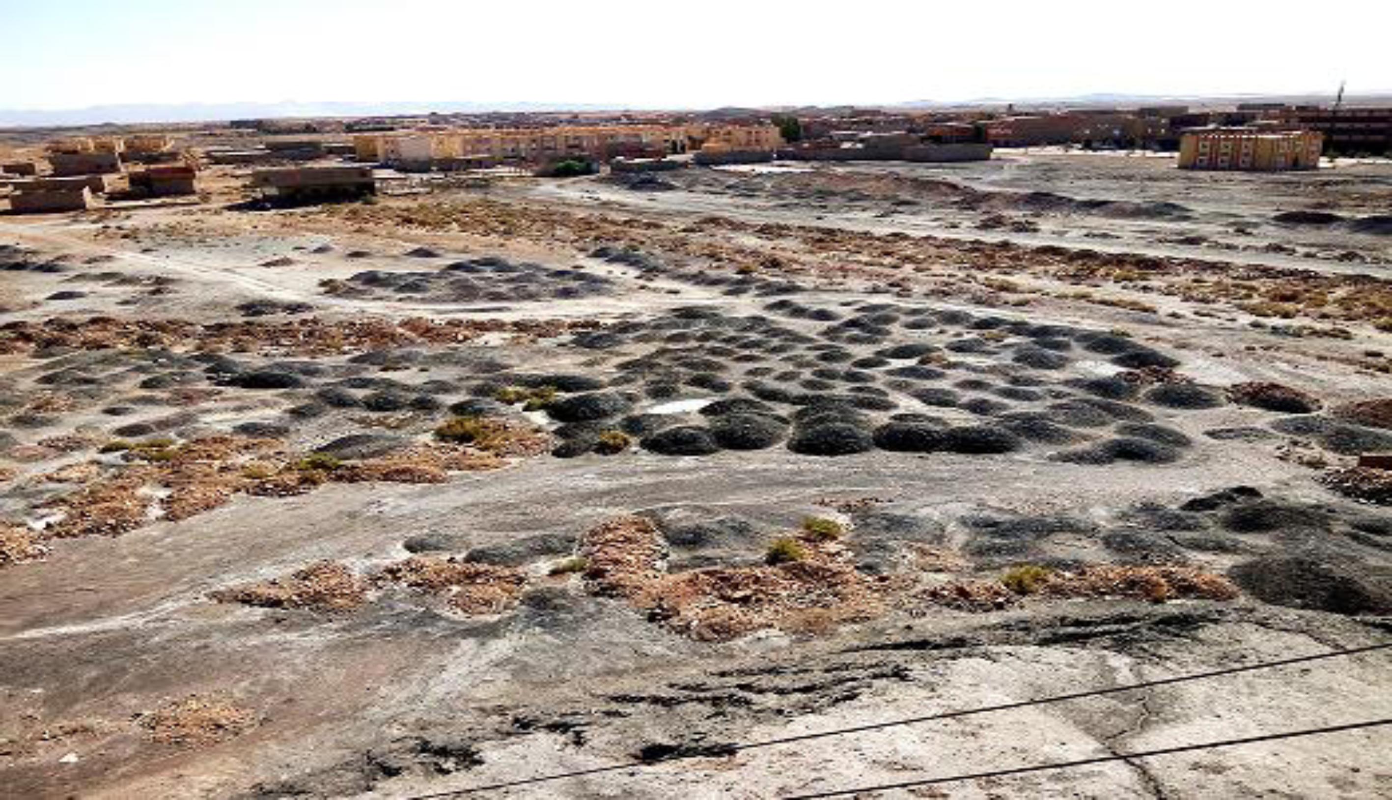
Figure 11
Landscape near spoil tips.
In the vast majority of cases, large spoil tips made of waste rock excavated during the digging of the galleries appear in the vicinity of the mines. “As the mining has been continued over a long period, huge excavations exist and other environmental problems, including air, water, noise pollution and deforestation occur” (Dutta and Mahatha, 2004, p. 243).
“In principle, this type of deposit should also be the subject of control measures, as regards the residual metal content. In discussions on brownfields, there is a general consensus among researchers that brownfield sites have the potential to be reused as green spaces” (Siikamäki et al., 2008), art “parks, commerce centres, recreational areas and residential lots” (Mathey et al., 2015).
The subsequent planting of plants on Spoil tips often faces many difficulties — it is necessary to foresee the actions of restoration of the site, which are essential.
The Consequences of spoil tips on water resources
The mining activity leads to an extensive water degradation, thereby creating a serious environmental problem. It disrupts the drainage, drops the water table and, more importantly, contaminates the surface and sub-surface water bodies. Consequently, the aquatic habitats are devasted. The environmental impact of the Kenadsa Spoil tips cannot be examined independently of the local water resources. “Open cast coal mine spoils are deficient in plant nutrients due to biologically rich top soil being removed and cause a serious problem for revegetation and restoration” (Maharana et al., 2015).
The effect of spoil tips on the urbanization of mining sites
As time goes on, the city of Kenadsa witnesses a remarkable expansion, causing encroachment on the easement area of mining sites. Eventually, at the entrance to Kenadsa on the laundry side, entire housing estates have already been built or are in the process of being built. Newly allocated plots of land are located squarely on the areas occupied by the heaps, just above the operating mining galleries (Figure 12). This practice, in urban spatial planning, does not primarily take into account the infrastructure related to the region's mining site. This can consequently present risks of disorder and slippage due to possible ground movements. New constructions at the foot of the slag heaps in the new urban area of Kenadsa are potentially exposed to the risk of landslides from unstable slag heaps (Figure 13) (O.N.R.G.M, 2003, p. 116).
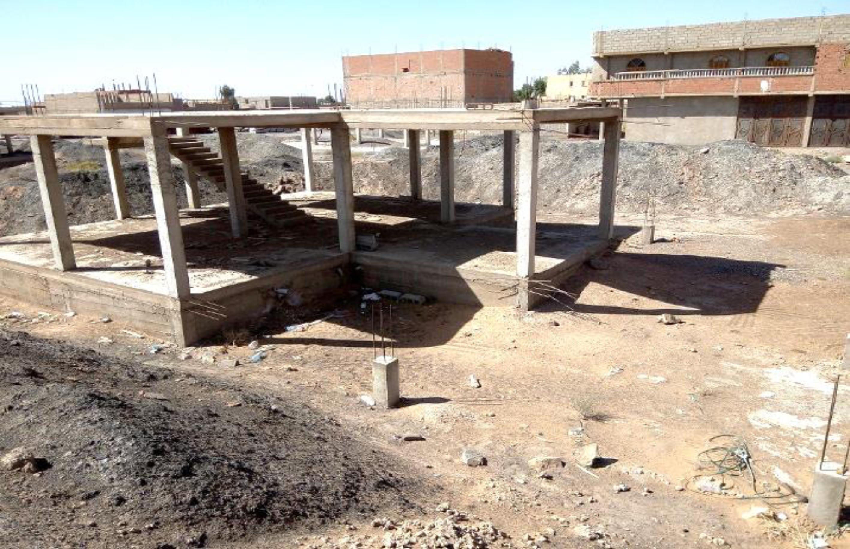
Figure 12
Housing developments near slag heaps and above underground mining tunnels.
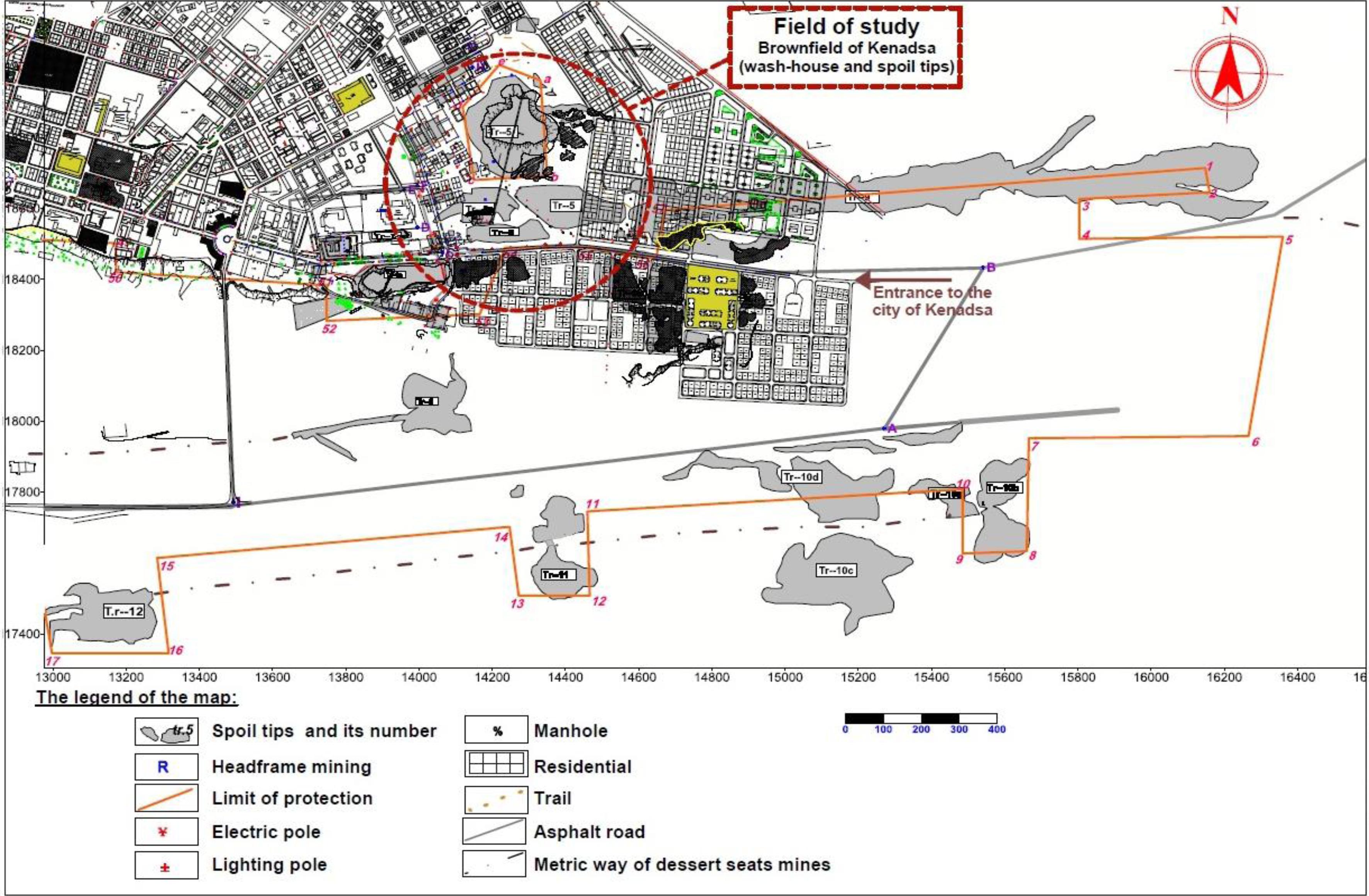
Figure 13
Urban plan for the extension of the city of Kenadsa, to the detriment of the protection limits.
(Source: O.N.R.G.M, 2003, p. 51)
The slag heaps which are located at the eastern entrance to the city are enclosed within residential agglomerations. These are relics of the mine waste dump that has been moved in order to establish urban infrastructures and build individual housing.
Currently, slag heaps are an integral part of the city's new urban sites, following the urbanization (developing along the road only) that does not take into consideration the constraints of the actual data of the mine site and its nonpossessory character (underground mining galleries, slag heap rights-of-way, disused pit tiles, etc.). Most of the underground structures associated with former mining operations are likely to collapse. In the case of abandoned underground chamber and pillar mining, the surface should not collapse, except in the event of flooding, which weakens the support pillars and poses a danger to the inhabitants.
Thus, former extraction sites still generate a certain number of nuisances, which may negatively affect the safety of people and property on the territory. Today, the wash-house in Kenadsa is a very popular place. Being an obligatory place of passage, the site, or more exactly, the wash-house, is constantly frequented by teenagers living around the mine site and who knowingly expose themselves to the danger of an unprotected and unsecured area. In short, it is about a site where security is absent (Figure 14).
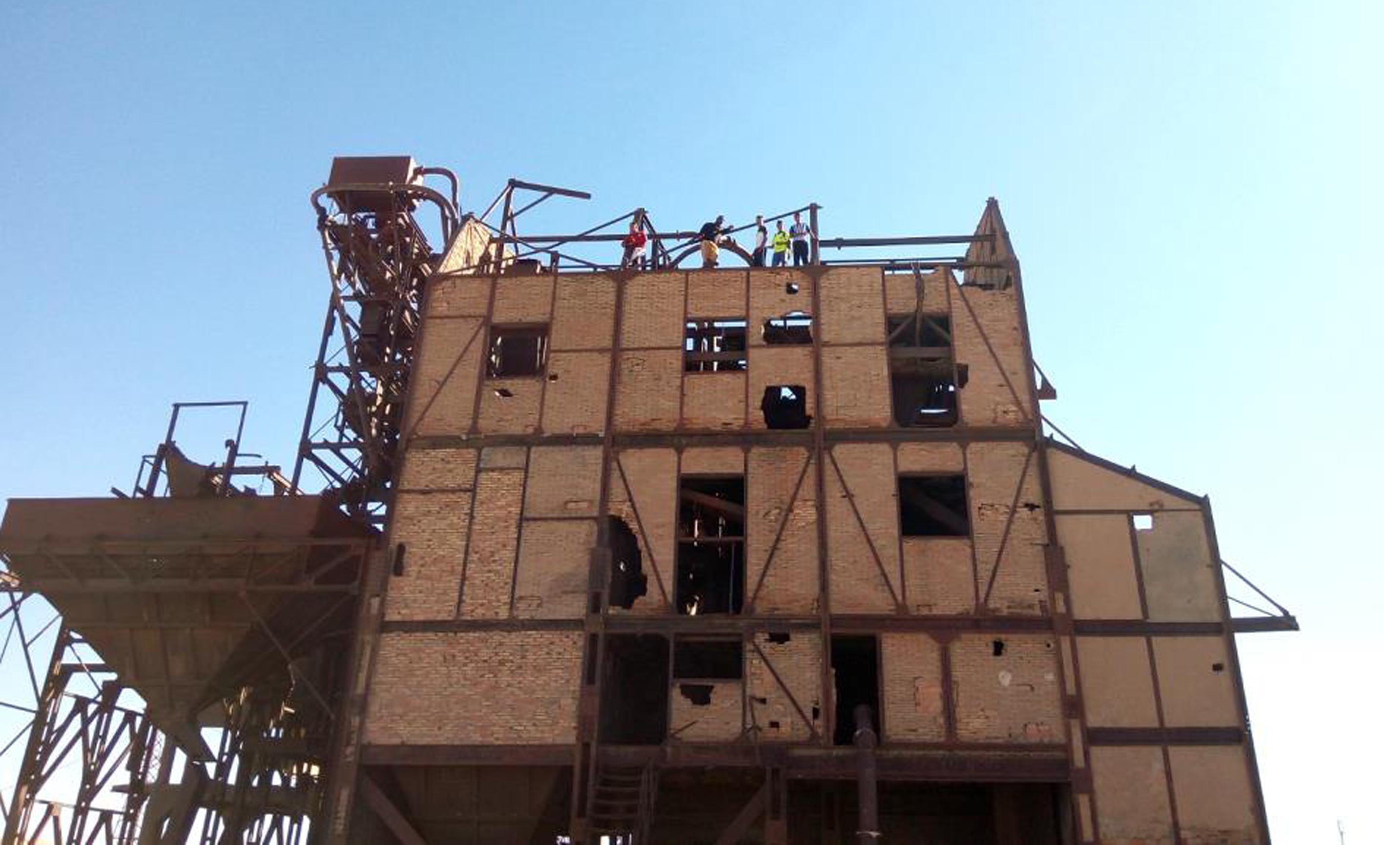
Figure 14
Teenagers climb the old wash-house and put their lives in danger.
The effect of spoil tips on hygiene and public health
In terms of public hygiene and sanitation, spoil tips are used by local residents to dump domestic waste and rubble storage sites, thus denaturing the environment, with potential risk to public hygiene (Figure 15).
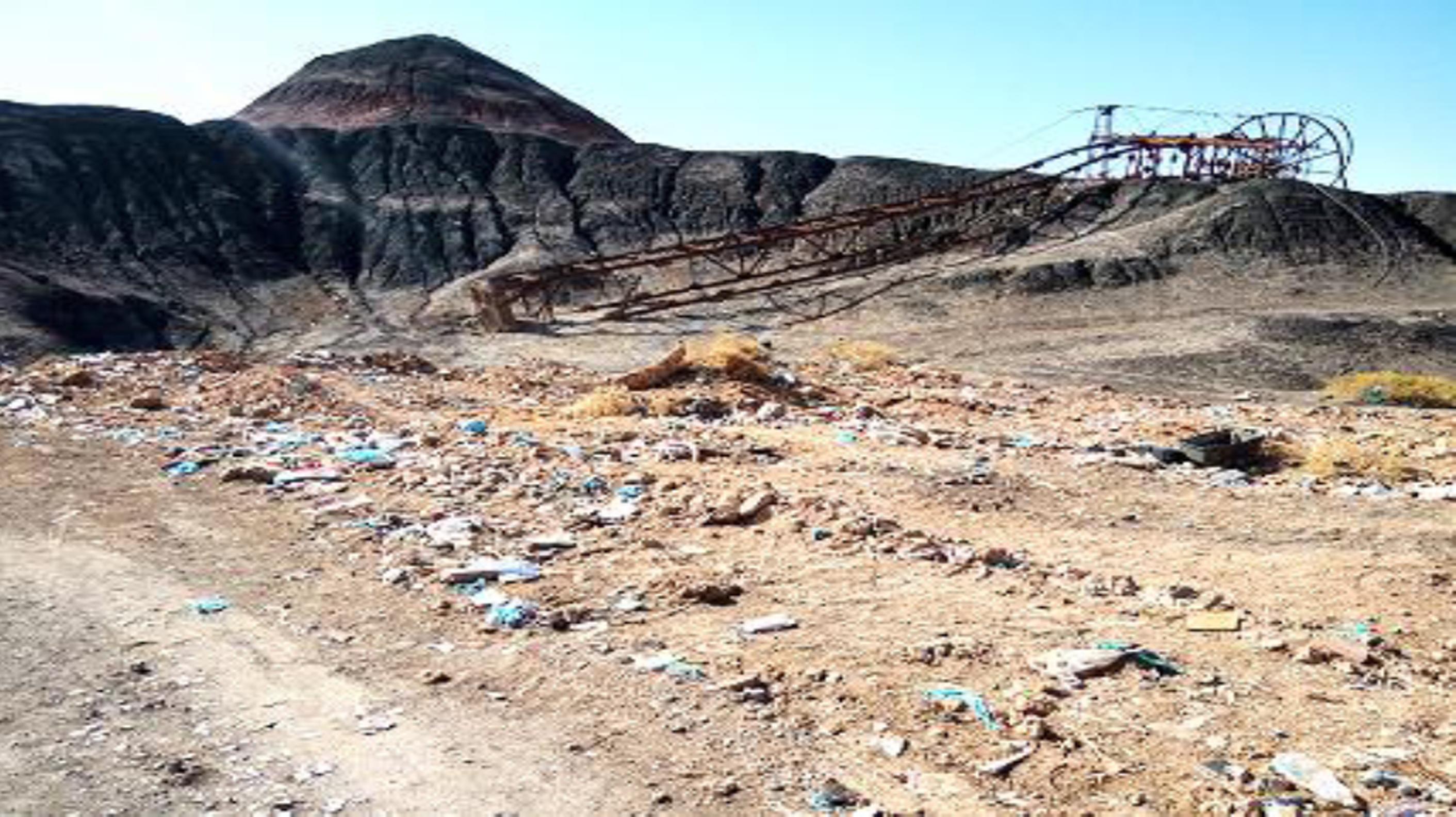
Figure 15
Amount of household waste on spoil tips.
The survey that we carried out with the health department of the city hall, the Pneumology Department of the health sector of Bechar, and a doctor specialized in the same field, but private, reveals that no epidemiological study was officially launched to explore the potential impacts of spoil tips on the health of the local population. Nevertheless, a non-negligible rate of nonspecific respiratory diseases (asthma and respiratory allergies) was noted in the region targeted by this study, which has a dry climate.
THE SUSTAINABLE DEVELOPMENT OF THE BROWNFIELD
Literature indicates that the world's active mines and exploration activities are located in areas of great environmental and social vulnerability. “Once mining is completed; countries require reclamation plans for coal mining sites to undo the effects on the environment and the surrounding habitat. A vast scale of land disturbance and displacement of people is caused by mining activities” (Whitmore, 2006).
The objective of this survey is to collect the opinions of the inhabitants as well as their perceptions regarding the existence of an industrial wasteland (represented by the wash-house and coal slag heaps) at the entrance of the city of Kenadsa, which perpetuates in the urban landscape for lack of an adequate legislative action. To meet the needs of this study, interviewing the inhabitants seems to be the appropriate method. “This can help put respondents at ease, build up confidence and rapport. More importantly, it often generates rich data, collected in a short period of time, between 15–30 minutes” (Ghiglione and Matalon, 1998), which subsequently develops the interview further. In this regard, fifty individuals living in the immediate vicinity of the brownfield site and who are not involved in the management of the administrative affairs of the town and hence have no interest in the area in question, were interviewed during all hours of the day and for more than two months. At this juncture, it is worth mentioning that the choice of the participants, which does not take into account the gender, age and the sociodemographic criteria, makes the delivery of spontaneous and unbiased speeches possible.
For the sake of providing an accurate character to the study, twenty other individuals were interviewed, including notabilities, former miners, newspaper correspondents, historians, professionals, and city managers. This allows thereafter to suggest a proposal that can deal with the traces of an industrial past which, at the same time, may put constraints on urban planning and harm the urban landscape and the environment.
The survey reveals that the industrial wasteland of Kenadsa is mainly defined as an abandoned place (51%), despite its location at the entrance of the city, where it remains a memorable symbol of an industry that existed in the past. It also represents the history of the region during the period of the French colonialism. At present, the town is in the centre of an urban environment. For this reason, the authorities must pay the greatest attention to this shared heritage (by converting it, for example, into an open-air museum).
An amount of 23.50% of the interviewees still hope that this space will receive the adequate care and be developed in the near future (as an open space that can accommodate a potential socio-economic project, for example). Moreover, 21.50% of the interviewees state that the wasteland has become a dump waste site. For decades, this area has become a site where the local residents deposit their household and daily waste, and the construction sites throw their rubble.
The rest of the people questioned, 4.00%, believe that, in spite of the richness of the wasteland in regard to its history with coal mining, it is, unfortunately, a contaminated area and obsolete industry that pollutes the soil and brings harmful diseases to the inhabitants (Figure 16).
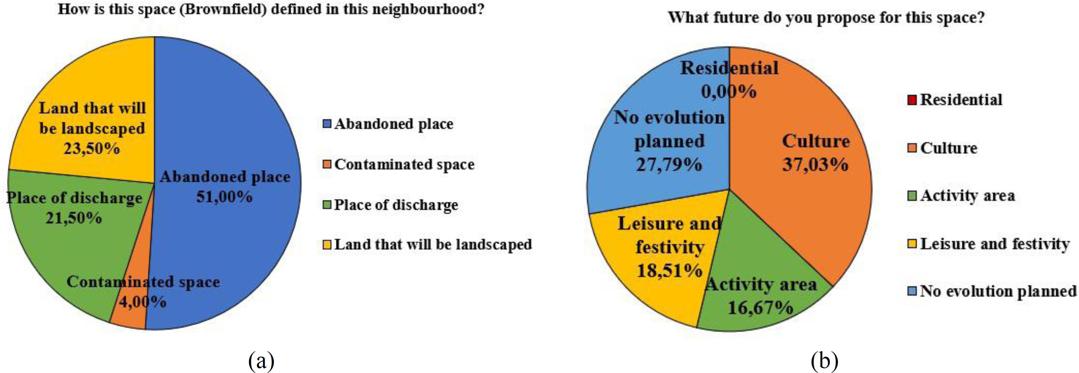
Figure 16
(a) Evaluation of sensory appreciations; (b) Reflection, Intervention on space.
In fact, this investigation suggests that the majority of the interviewees (37%) propose as a substitute a space that can accommodate a function that has a cultural vocation (museum, craft centre, tourist space, amusement park, garden, etc.). Similarly, 19% of respondents believe that this space can accommodate a leisure and festive function (amusement park). An amount of 16% suggest an activity area (reallocate the old function or make an investment). But no one has given a residential vocation, given their fear that this space could endanger their health and life (diseases, risk areas, presence of galleries in the basement and respect for the historical and heritage value of industrial wasteland). However, 28% see the space as a place that will have no future, owing to the ineffective administrative machinery.
The survey conducted in the city of Kenadsa reveals that the alternative development of industrial sites and these dumps closest to urban agglomerations seem the most reasonable and least restrictive (finances; time; consequences on the environment).
This variant deals with the transformation of slag heaps and neighbouring land in holiday and resting areas (e.g., public gardens, monuments) or leisure areas (team sports grounds, slides, festival place, etc.) (Figures 17).
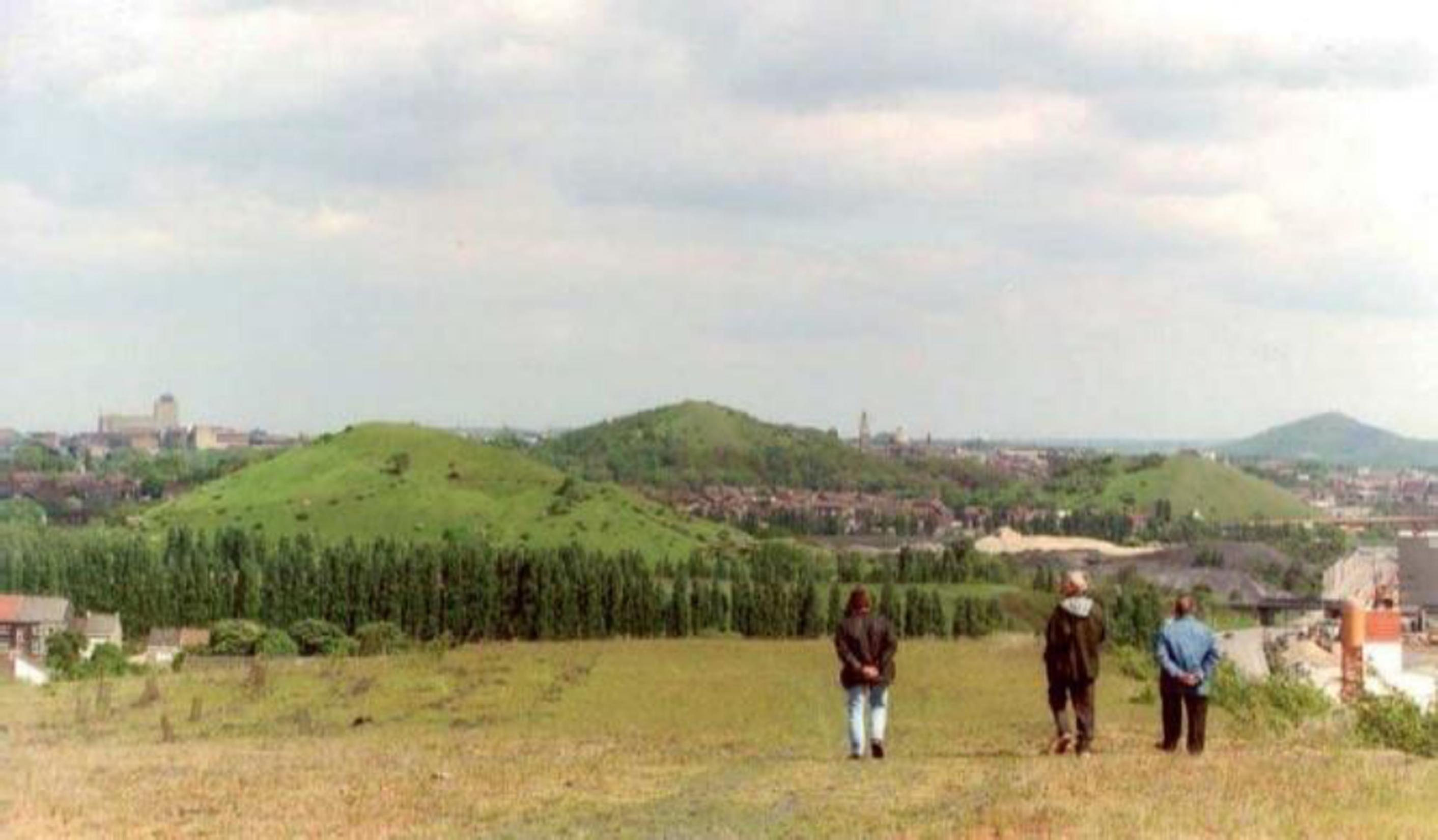
Figure 17
Spoil tips transformed into a sustainable landscape.
(PIRET, M; VAN DEN BERGE, M. 2006, https://www.espace-environnement.be/wpcontent/uploads/2015/08/Valorisation_terrils_Brochure.pdf. recovered on March 02, 2017)
In regard to the variant in question, it is worth stating that the decision to prohibit building on land with tunnels at depth, or at the limits of slag heaps, is strictly necessary. “The reuse of brownfields extends many environmental, economic and community benefits, that make many countries all over the world found out that investment in brownfields pays off in many ways.” (El khateeb et al., 2013, p. 3). “These are minimizing the use of resources, minimizing pollution, protecting biodiversity and the natural environment, protecting the industrial heritage and protecting the cultural environment.” (Dixon, 2006). “And reduce the threats contaminated, and inconvenience sites affect to public health is also important” (June Beck et al., 2005, p. 2–5).
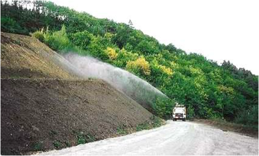
The slag heaps of significant size and part of the urban fabric could be covered with plant tissues through a pilot agro-pedological study, with the use of local plant species and supplementary irrigation to ensure the sustainability of this vegetation cover and thus making the greening of the slag heaps possible.
The regreening of slag heaps, a general principle of plant and landscape accompaniment, confers a renaturation aspect to the site. Furthermore, the plantations make it possible to stem the erosion of the slopes.
“They can weld together halved neighbourhoods, recreate links or, on the contrary, constitute buffer zones between differentiated social or functional spaces. Moreover, the appropriation of wastelands requires the definition of a new urban character.” (Senecal and Saint-Laurent, 1999, p. 41).
Whether it is an old mining, brownfield or landfill site, the whole population should appeal to forest engineers and agronomists to improve the landscape or to regain a degraded area. With the discretion that characterizes them. But, above all, with their experience and vast imagination, foresters can patiently recover man-made spaces before making them pleasant for other uses.
In these especially “ungrateful sites”, nature, despite particularly careful care, sometimes struggles to regain its full rights. But overall, the results are satisfactory and seem to live up to citizens' expectations (Figures 18 and 19).

The idea to create places and routes for walks and relaxation, placed around history, earth and technology sciences of the region (an open-air museum) solicits the exploitation of the sites' possibilities without denying their past. The new development would be a space for historical, scientific and heritage discovery of the town.
From this point on, we think it would be interesting to create a leisure park without borders around the old mine buildings, for example, the laundry site in Kenadsa would serve as a media library to popularize access to information technology, communication, and mining heritage.
In addition, the popular festivals at official ceremonies have long characterized the town and been a perfect means of seduction. This enables the city to be culturally active in specific dates per year around the remains of a former industrial activity. In this sense, the current ambitious policies of renewal and animation in industrial contexts can rely on celebration and culture in general (Figures 20).
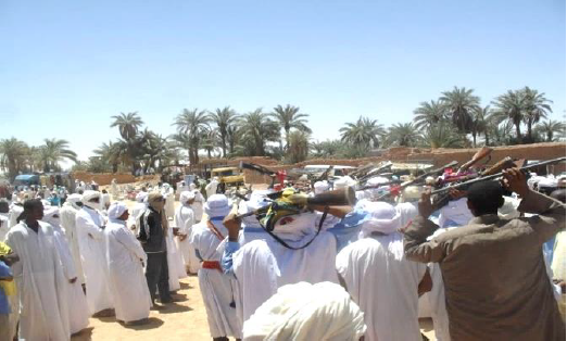
Figure 20
Types of cultural religieuse events in Kenadsa.
(https://www.nafhamag.com/wpcontent/uploads/2015/12/%D9%82%D9%86%D8%A7%D8%AF%D8%B3%D8%A9.jpg.webp. recovered on December 03, 2017)
If the feast represents an ephemeral moment in the history of urban transformations, regular popular festivals reveal great success in terms of the social landscape. As elsewhere in the world, the cultural events successfully demonstrate social and educational projects, a kind of cultural regeneration, in a formerly industrial space, which promotes urban and environmental regeneration.
CONCLUSION
The city of Kenadsa has evolved from a commercial stopover, a trans-Saharan axis and an attractive religious centre in the middle of the Arab Maghreb to a city with of an outstanding mining status that resulted in a prosperous economic boom. This city certainly flourished during industrial activities, while after bankruptcy or expiry of the ore, it was abandoned, leaving deep scars. The form of appropriation of the environment following mining and its abandonment has had serious consequences for the city. As a result, the city embodies the negative stereotype of a depressed postindustrial city.
Having been greatly exploited in the past, Kenadsa, today is totally abandoned, giving little desire to walk around. The post-industrial landscape highlights a sad aspect, which is clearly marked by human activity. It bears the scars (reveals signs and discloses the imprints of economic activity), which the spirit remembers, thanks to the vacant and abandoned industrial sites, but marked by a few wastelands.
Kenadsa's former brownfield, abandoned pit tiles, slag heap rights-of-way, and underground mining tunnels can have significant impacts on the environment and health of residents. Indeed, it results from mining operations that may have a possible contribution to changes in the geological environment, aquifers, and possible alterations in air and water quality, dust, and the achievement of landscape integrity. These repercussions likely degrade the urban environment.
In fact, underground or opencast mining has always had harmful consequences for nature and populations during and well after the exhaustion of deposits: dust; noise; disfigured nature; slag heaps; landslides and collapses; the birth of lagoons.
These sites are most valuable when mining developments and their landscape settings maintain rich and multiple visual relationships. Today, this is not always the case, due, in particular, to the presence of tree structures that hinder these visual interactions, or uncontrolled urban development that can weaken existing relationships between mining elements and their landscape environment.
The visual and physical links between mining sites and the large landscapes that accompany them deserve to be protected, strengthened and enhanced.
The recovery of this industrial wasteland can embody the transition from a system where the mine in a centrifugal movement was the driving force that shaped the city to a system where it is the city, in a centripetal movement, that recaptures the space left vacant by the industry.
The transformation of these places, after rehabilitation, into protected sites would only be a timid acknowledgement of the memory of the region, of our ancestors and especially the memory of the miners, who erected them thanks to the sweat of their brows and the suffering of their bodies.
Moreover, intervention on these damaged sites can be part of the trend towards the renewal of the city on its own and achieve sustainable development. This principle is perfectly in line with the concept of sustainable development: it is about restoring rather than demolishing, reusing wasteland rather than promoting urban growth on the periphery, and strengthening social cohesion by all possible means.
REFERENCES
AZIZI, A. 2016. Chronique du coeur et du regard, Oran, Edition Dar Elqods, 259 p.
CUTRUNEO, C.M.; OLIVEIRA, M.L.; WARD, C.R.; HOWER, J.C.; DE BRUM, I.A.; SAMPAIO, C.H.; KAUTZMANN, R.M.; TAFFAREL, S.R.; TEIXEIRA, E.C.; SILVA, L.F.O. 2014. A mineralogical and geochemical study of three Brazilian coal cleaning rejects: demonstration of electron beam applications. International Journal of Coal Geology, 130(9), 33-52. https://doi.org/10.1016/j.coal.2014.05.009
DANIELSON, L. 2006. Architecture for change: An account of the mining, minerals and sustainable development project, Global Public Policy Institute, Berlin, p. 19-20.
DAS, N.; MISHRA, N. 2015. Assessing the impact of coal mining on diversified sources of rural livelihoods: A case study in the Ib Valley coalfield area of western Odisha, India. International Research Journal of Social Sciences, 4(6), 83-88.
DIXON, T. 2006. Integrating Sustainability into Brownfield Regeneration: Rhetoric or Reality? – An Analysis of the UK Development Industry. Journal of Property Research, 23(3), 237–267. https://doi.org/10.1080/09599910600933889
DUTTA, P.; MAHATHA, S.; DE, P. 2004. A methodology for cumulative impact assessment of opencast mining projects with special reference to air quality assessment. Impact Assessment and Project Appraisal, 22(3), 235-250. https://doi.org/10.3152/147154604781765905
EL KHATEEB, S.; ABD ELRAHMAN, S. 2013. Brownfields in G.C.R.: A neglected potential for redevelopment the old city. In: CONFERENCE CITIES TO BE TAMED? STANDARDS AND ALTERNATIVES IN THE TRANSFORMATION OF THE URBAN SOUTH, 26, Milan, 2013. Procedings… Milan, Published in Planum. The journal of urbanism, 26(1), 1-13.
GHIGLIONE, R.; MATALON B. 1998. Les enquêtes sociologiques: théories et pratique, Paris, A. Colin, 301 p.
JUNE BECK, N.; CHAN, V.; KALRA, B.; MCPHAIL, L.R.; SCHNEIDER, M.R.; SOMERS, D.; TRAXLER, S.E.; WANG, X. 2005. New Directions for vehicle city: A framework for brownfield reuse. Urban and Regional Planning, University of Michigan – Ann Arbor, April 29.
MAHARANA, J.K.; DAKUA, C.; PATEL, A.K. 2015. Isolation and characterization of a chemolithotropic bacterial strain from fresh coal mine overburden spoil. International Journal of Advanced Research in Biological Sciences, 2(7), 28-39.
MATHEY, J.; RÖßLER, S.; BANSE, J.; LEHMANN, I.; BRÄUER, A. 2015. Brownfields as an element of green infrastructure for implementing ecosystem services into urban areas. Journal of Urban Planning and Development, 141(3), 75-79.
MEHDIPOUR, A.; HODA, R.N. 2013. The Role of Brownfield Development in Sustainable Urban Regeneration. Journal of Sustainable Development Studies, 4(2), pp. 78–87.
PIRET, M; VAN DEN BERGE, M. 2006. Plan a new valorization of heaps in the city and the region. Available at: https://www.espace-environnement.be/wp-content/uploads/2015/08/Valorisation_terrils_Brochure.pdf
REGIONAL UNIT OF THE NATIONAL GEOLOGICAL AND MINING RESEARCH OFFICE OF BECHAR (O.N.R.G.M). 2003. Study of the conditions of management of the Spoil tips of the cities of Bechar and Kenadsa. Bechar, 206 p.
SENECAL, G.; SAINT-LAURENT, D., 1999. Espaces libres et enjeux écologiques : deux récits du développement urbain de Montréal. Recherches sociographiques, 40(1), 33-54.
SIIKAMÄKI, J.; WERNSTEDT, K. 2008. Turning brownfields into greenspaces: Examining incentives and barriers to revitalization. Journal of health politics, policy and law, 33(3), 559-593. https://doi.org/10.1215/03616878-2008-008
WHITMORE, A. 2006. The emperor’s new clothes: Sustainable mining. Journal of Cleaner Production, 14(3), 309-314.