Artigos
SALINITY OF THE SOIL AND THE RISK OF DESERTIFICATION IN THE SEMIARID REGION
SALINIDADE DO SOLO E RISCO DE DESERTIFICAÇÃO NA REGIÃO SEMIÁRIDA
SALINIDAD DEL SUELO Y RIESGO DE DESERTIFICACIÓN EN LA REGIÓN SEMIÁRIDA
SALINITY OF THE SOIL AND THE RISK OF DESERTIFICATION IN THE SEMIARID REGION
Mercator - Revista de Geografia da UFC, vol. 19, no. 1, pp. 1-15, 2020
Universidade Federal do Ceará
Received: 04 October 2019
Accepted: 17 October 2019
Abstract: The salinity of the soils is one of the problems that most contribute to the degradation of the soils of the regions susceptible to desertification. This problem is present in many parts of the world, including Brazil. In this context, the objective of this article is to analyze the process of salinity of the soils in different land uses in municipalities of the Mesoregion of São Francisco (semi-arid of the State of Pernambuco). For this, samples of soils collected on diverse uses and occupations of the lands were submitted to chemical tests besides the identification of the class of soil to which each sample belongs. The results indicate that the areas on irrigated agriculture present the main sources of salinity, mainly in the places where the irrigation is performed through underground water. Unidentified problem on the samples collected in the Caatinga and partially found on the areas of exposed soils and those submitted to temporary agriculture (dryland). In the study region, inadequate agricultural management is one of the main responsible for salinity of the soils, and the impacts contribute to the increase of the risks to local desertification.
Keywords: Soil degradation, Salinization, Semi-arid, Desertification.
Resumo: A salinização dos solos é um dos problemas que mais contribuem para degradação dos solos das regiões susceptíveis à desertificação. Problema presente em várias partes do mundo inclusive no Brasil. Nesse contexto, o objetivo desse artigo é analisar o processo de salinização dos solos em diferentes usos das terras em municípios da Mesorregião do São Francisco Pernambucano (semiárido do estado de Pernambuco). Para isso, amostras de solos coletadas sobre diversificados usos e ocupações das terras, foram submetidas a testes químicos além da identificação da classe de solo a qual pertence cada amostra. Os resultados indicam que as áreas sobre agricultura irrigada apresentam os principais focos de salinização, principalmente nos locais onde a irrigação é desenvolvida através de água subterrânea. Problema não identificado sobre as amostras coletadas nas caatingas e, parcialmente encontrados sobre as áreas de solos expostos e as submetidas à agricultura temporária (sequeiro). Na região de estudo o manejo agrícola inadequado é um dos principais responsáveis pela salinização dos solos e, os impactos contribuem para ampliação dos riscos à desertificação local.
Palavras-chave: Degradação dos solos, Salinização, Semiárido, Desertificação.
Resumen: La salinización de los suelos es uno de los problemas que más contribuyen a la degradación de los suelos de las regiones susceptibles a la desertificación. Problema presente en varias partes del mundo incluso en Brasil. En este contexto, el objetivo de este artículo es analizar el proceso de salinización de los suelos en diferentes usos de las tierras en municipios de la Mesorregión del San Francisco (semiárido del Estado de Pernambuco). Pernambucano. Para ello, muestras de suelos recolectadas sobre diversos usos y ocupaciones de las tierras, fueron sometidas a pruebas químicas además de la identificación de la clase de suelo a la que pertenece cada muestra. Los resultados indican que las áreas sobre agricultura irrigada presentan los principales focos de salinización, principalmente en los lugares donde la irrigación es desarrollada a través de agua subterránea. Problema no identificado sobre las muestras recogidas en las caatingas y, parcialmente encontradas sobre las áreas de suelos expuestos y las sometidas a la agricultura temporal. En la región de estudio el manejo agrícola inadecuado es uno de los principales responsables de la salinización de los suelos y los impactos contribuyen a la ampliación de los riesgos a la desertificación local.
Palabras clave: Degradación del suelo, Salinización, Semiárido, Desertificación.
INTRODUCTION
Desertification is a dynamic process developed from land degradation in arid, semi-arid, and drysub-humid areas of the world, resulting from the environmental characteristics of these areas, as well asfrom the anthropic practices of resource exploitation in the mentioned areas. (UNNCCD, 2014).
It is estimated that much of the land located in dry climates present problems or marked risks todesertification (D 'ODORICO et al., 2013). You can name cities such as Mexico (BECERRIL-PIÑA etal., 2015); India (VARGHESE & SINGH, 2016) and in other parts of the world. In Brazil, the scenariois no different. In the Brazilian region where the climate can be considered semi-arid, the risks ofdesertification are eminent, and in some places the degree of land degradation is so severe that they havebecome a desertification core. (BRASIL, 2007; PEREZ-MARIN et al., 2012).
Something in common unites more than half of the risk areas, or in an advanced state ofdesertification, it is the dynamics of land use and occupation. According to D 'ODORICO et al. (2013),the use of agricultural land and dry forests without proper planning and management favors thedegradation of soils and the reduction of biodiversity in these environments.
Among the engines of desertification is soil salinization, which is the result of the accumulation ofsoluble salts in the arable land layers (LUO et al., 2017). As a consequence, there is plant poisoning andincreased osmotic pressure on the vegetation inserted in salinized areas. (PEDROTTI, 2015;GKIOUGKIS et al., 2015), resulting in vegetation cover and agricultural production losses.
The salinization process is due to environmental characteristics and anthropic actions(DALIAKOPOULOS et al., 2016). Natural characteristics include the transport of salt sediments fromsalinized areas to unsalted sites; actions of ascent by capillarity of the soils to surface; high rates ofevapotranspiration, among other factors (RIBEIRO, 2010; BRADY & WEIL, 2012; PEDROTTI, 2015;WALTER et al., 2018).
The human actions that contribute to salt accumulation are varied, highlighting: the use of watercontaining high quantities of salts (DALIAKOPOULOS et al., 2016); irrigation practice withoutdrainage system; application of fertilizers and pesticides with a high salt concentration in theircomposition (RIBEIRO, 2010; KANZARI, et al., 2012; PEDROTTI, 2015; SALVATI & FERRARA,2015).
The impacts of soil salinization directly affect the dynamics of the spatial organization ofpopulations, promoting the reduction of agricultural production, population displacement, highlightingthe food security and economy of affected communities. Several studies point to the problemspreviously mentioned, especially Haron and Dragovich (2010) in Australia, Xu et al. (2014) in China,and in the Northeast of Brazil with Souza, Queiroz, and Gheyi (2000) and Vasconcelos et al., (2013).
Assessing the degree of salinization, the risks and the main contributing factors to the excess saltin the soils of desertification-susceptible areas becomes crucial, since it is a fundamental factor for theplanning and promotion of public actions and policies for the proper management of each environment.In this context, the present study aims to analyze the degree of soil salinization in different land uses inmunicipalities of the Mesoregion of São Francisco, semi-arid state of Pernambuco, and its possiblecontribution to the process of local desertification.
The study area was selected based on the survey developed by Castro and Santos (2015), whichshowed that the municipalities studied have 39% of their territories with medium susceptibility tosalinization. Other factors affected the selection and development of this study. These include theimportance of the part of the local lands for the development of irrigated agriculture, frequent use ofunderground water for irrigation in non-irrigated agriculture areas, and rudimentary knowledge aboutthe process and impacts of salinization of local soils.
STUDY AREA
The study was performed in the municipalities of Petrolina, Lagoa Grande, Dormentes, Afrânio,and Santa Maria da Boa Vista, western Pernambuco state (Figure 1), and belonging to the São FranciscoPernambucano Mesoregion. Both municipalities are under semi-arid climate, with an annual averagerainfall of 700 mm concentrated at the end and beginning of each year; caatinga vegetation; soils withmedium to few degrees of development; terrain marked by the "Sertaneja" Depression and inselbergs(BELTRÃO et al., 2006).

Figure 1
Location of the municipalities where the study was performed.
Elaborated by theauthors, 2018.
The economic structure in these municipalities varies, even though the basis is the agriculturalproduction with an emphasis on the irrigated fruit sector in the municipalities of Petrolina, LagoaGrande, and Santa Maria da Boa Vista, and the goat and sheep livestock in the other municipalities.(IBGE, 2017).
METHODOLOGICAL PROCEDURES
For the development of the present study, sixteen samples of soils were collected, together withpieces of information regarding land use and occupation (Table 1). For data collection, we used: fieldbooks, Global Positioning System (GPS) receiver apparatus, plastic packages, cameras, and tapemeasures.
The criteria for choosing the locations for soil sampling considered the use and occupation of theland in the following categories: caatingas, rainfed/exposed soil and irrigated agriculture. Each samplingwas performed in a 30 cm profile (root area of the plants) with the removal of approximately 1 kg ofsoil.

Elaborated by theauthors, 2017
The samples were sent to the Soil Laboratory of the Federal Institute of Sertão Pernambucano(IFSertão), a rural zone campus, where the analysis of pH (Hydrogenionic potential), EC (ElectricalConductivity) and ESP (Exchangeable Sodium Percentage) was performed. Analyses were performedaccording to the EMBRAPA Soil Analysis Methods Manual (2011).
In the laboratory, the first step was the exposure of the collected materials for moisture loss,followed by the screening process with 2 mm mesh. For pH definition, a table pH meter was used. ThepH “is a measure that allows describing the acidic or basic character that predominates in an aqueousmedium, considering its value determined on a scale from 0 to 14” (LEPSCH, 2011, p.210-211). The pHbelow 7 classifies the soil as acidic, the pH 7 is neutral while the pH above 7 indicates an alkaline soil.(MCCAULEY, OLSON-RUTZ & OLSON-RUTZ 2017).
For the EC analysis, a vacuum pump was used to remove the liquid part of the samples that weremoistened 6 hours before the analysis. The sample taken was analyzed through the table Conductivitymeter and the results presented in dS.m-1.
ESP is the percentage of exchangeable sodium relative to CEC (Cation Exchange Capacity). ESPdetermination was performed in phases. First, the following elements were defined separately: Ca2+(Calcium); Mg2+ (Magnesium); Na+(Sodium); K+ (Potassium); H+Al (Hydrogen + Aluminum) andthen calculated ESP using equation 1:

Equation 1
Equation 1
Where: is the exchangeable sodium content in cmolckg-¹ , and the CEC is the capacity of cationexchange in cmolckg-¹ obtained by summing Ca, Mg, Na, K, and H+Al.
The exchangeable sodium grade was assessed according to the EMBRAPA (2015) classification,in which the soil with ESP: less than six is considered low; 6 to 15 is medium, and values above 15 arerated high.
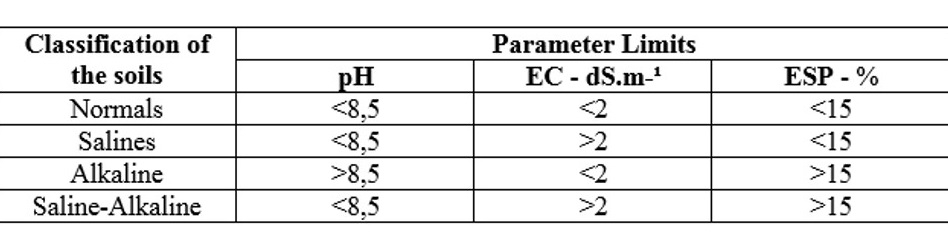
For the classification of soils taking into account the presence of surface salts, from pH, CE, andESP, the initially proposed methodology by Bohn et al. (1985) was used and presented in Table 2. Thesalinity effect on vegetation was assessed according to Richards (1954) was used, as described in Table3, using CE.

IRRIGATED AGRICULTURE
Figures 2A, 2B, and 2C show the pH, EC, and ESP of the 6 soil samples, respectively, collectedin areas under irrigated agriculture. The data highlight that the pH ranged from 5.35 to 6.88, among thesamples. These values can be classified below neutrality with slight degrees of acidity (Figure 2A).AM1 presented pH 6.88, which was the closest to neutrality. In this context, none of the samples inirrigated agriculture presented alkaline pH.
The acidic pH values in irrigated agriculture environments result from the frequent presence ofwater that contributes to the leaching of non-acid cations responsible for increasing the pH values.Generally, when the amount of acid cations increases, the pH of the soil solution tends to decrease(BRADY & WEIL, 2012). Provin and Pitt (2017) described similar results. The authors claimed that thehigh amount of water used in the irrigated systems plays a crucial role in reducing pH through theleaching process.

Figure 2
A) pH; (B) EC and (C) ESP land in an area under irrigated agriculture
Elaborated bythe authors, 2017.
EC values ranged from 0.30 to 11.72 dS.m-1 (Figure 2B). The samples AM4 and AM5 displayedvalues of 0.30 and 0.61 dS.m-1, respectively, being the lowest conductivity results found for irrigatedagriculture. Values that classify these as non-saline, according to the Richards (1954) classification.However, when analyzing the management implemented in the sampling area, concerns arise about thefuture chemical status of some of the soils in irrigated agriculture areas. These concerns arise because, inthese samples, farmers use furrow irrigation (Figure 3B) over a Planosol.
Planosols present, in the A horizon, sandy or medium sandy texture; however, in the B horizon,there is a high activity clay, thus providing drainage difficulty (EMBRAPA, 2006). Lepsch (2011)observes that in many places in northeastern Brazil the Planosols are Natric. That is, they havecharacteristics of high sodium saturation.
Based on the two studies mentioned above, drainage deficiency and high sodium saturation arerisk factors for the salinization of these soils if they are poorly managed, as it has been occurring in thecase study area.
The AM1 samples, taken from a Quartzarenic Neosol, AM2 over a Luvisol, and AM3 over anArgisol present an EC of 3.55; 2.07 and 2.20 dS.m-1, respectively (Figure 2B). Although QuartizarenNeosols are well-drained, the EC value found in their sample is the result of years of irrigation and lackof drainage engineering built in the area under Carica papaya (papaya) plantation in Petrolina (Figure3A). The soils of the AM2 and AM3 samples have a textural B horizon that hinders rapid infiltration, afeature that favors the permanence of water over the arable horizon and, consequently, accumulatingsalts.

Figure 3
Areas under irrigated agriculture where samples were collected. (A) papaya plantation inPetrolina; (B) planting of banana with furrow irrigation in Santa Maria da Boa Vista and (C) planting ofgrass and sugar cane in the municipality of Dormentes.
Elaborated by the authors, 2017.
Taking into account the number of salts found in the soils of the AM1, AM2, and AM3 samples,the Richards (1954) classification classifies these samples as slightly saline based on the values foundfor EC, which ranged between 2 and 4 dS.m-1.
The highest value found for EC was in the sample AM6, municipality of Dormentes, totaling11.72 dS.m-1, classifying this sample as highly saline, according to Richards (1954). One of the factorsjustifying the high EC is the use of water extracted from local aquifers to irrigate corn (Zea mays) andbuffelgrass crops (Cenchrus ciliaris) (Figure 3C). Much of the underground water in the municipality ofDormentes have high salt concentrations according to Ramos (2014). Consequently, the use of thesewaters in irrigated agricultural activities increased the concentration of salts to the Fluvic Latosolsignificantly, where the samples AM6 was sampled, and, consequently, contributing to increasing therisks of desertification in these areas.
Another feature that favors the high EC value in sample AM6 is its location, which is just afterfoothills and in the flood area of an intermittent stream. As for the proximity of the foothills, accordingto Ribeiro (2010), this favors salinization by receiving salts from the higher surrounding areas, by thegravitational effect. About the flooded areas, the soils located there tend to present salinization problemsdue to the almost constant presence of water during the rainy season, which results in the accession andaccumulation of salts in the superficial horizons.
ESP (Exchangeable Sodium Percentage) values for irrigated agriculture ranged from 1.62% to25.21% (Figure 2C). The samples with the lowest ESP were AM1, AM3, and AM4, with values of2.35%, 1.67%, and 2.56%, respectively. In samples, AM2 and AM5 the ESP, with values between 6 to15% was considered average, according to EMBRAPA (2015). In sample AM6, underground waterirrigated agriculture area in the Dormentes municipality, ESP was 25.34%, above 15%, which accordingto EMBRAPA (2015) is considered high. The value in sample AM6 is due to soil characteristics as wellas local land-use practices, as previously mentioned. Above 15% ESP, according to Pistocch et al.(2017) indicates severe soil deterioration due to excess sodium.
For a better understanding of the concentration and distribution of the salts in the soils was usedthe Bohn et al. (1985) classification described in Table 2. This classification combines pH, EC, and ESP.Among the six samples, AM6 presented the worst result. The result is because this sample presentedESP higher than 15%, EC higher than two dS.m-1, and pH lower than 8.5. Combinations that classifythe soil in this sample as saline-sodium. Problems reported previously because of high-saltconcentrations in underground water used on a Fluvic Neosol.
Saline-sodium soil is characterized by the presence of soluble salts and sodium (EMBRAPA,2006). The amounts of sodium and soluble salts found in the analized samples are sufficient to causeosmotic stress and other damage to vegetation development (FERREIRA, SILVA & RUIZ, 2010)
The samples AM1, AM2 and AM3 displayed a slightly better situation. According to theclassification of Bohn et al. (1985), they are considered saline. The classification is defined because thepH was below 8.5, EC above 2 dS.m-1, but the ESP did not exceed 15%.
Saline soil presents an accumulation of soluble salts, which usually are flocculated and which permeability is similar to that observed in non-saline soils (FERREIRA, SILVA & RUIZ, 2010;RIBEIRO, 2010). Despite the favorable permeability, care should be taken in the studied samples due tothe presence of salts on their surfaces and the high susceptibility of these soils to salinization, since thesoil of AM2 is Luvisol and in the sample AM5 Planosol.
For the other samples, AM4 and AM5, the combinations of the three analytical parametersclassify them as normal according to the classification of Bohn et al. (1985). The classification of thesesoils as normal was performed according to the individual EC and pH assessments presented above.These samples derived from soils susceptible to salinization (Table 1), but the use of irrigationtechniques without the use of furrows, the distance from the São Francisco river in comparison to theother samples, and the recent banana cultivation performed in these same locations probably influencedthe results of normality of these samples.
RAINFED AGRICULTURE/EXPOSED SOIL
Figures 4A, 4B and 4C show the pH, EC, and ESP of soil samples, respectively, collected in areasunder rainfed agriculture (cultivation in the rainy season) and exposed soil (Figure 5).
The results displayed small pH variations, between 4.79 to 7.04 (Figure 4A). Considering the landuse of the collection points, our analyses displayed that almost all the samples were taken from exposedsoil sites. Only AM12 was collected from rainfed agriculture, resulting in a pH of 6.64 consideredslightly acidic. The AM8 samples displayed the lowest pH value -4.79, being considered as acid andunproductive soil for several crops. The pH of the sample AM9 was 7.09, characterizing this soil as veryclose to the neutralized one.
For the EC values, the points on rainfed agriculture/exposed soil displayed a discrepancy of 0.21to 35.94 dS.m-1 (Figure 4B). AM12 (Figure 4B) presented the lowest EC value for rainfedagriculture/exposed soil, which was 0.21 dS.m-1. According to these results, the sample could beclassified as non-saline soil. What would you expect from a flat area over Fluvic Neosol, whichaccording to Silva, Silva, and Barros (2008) has relative salinity potentiality? An area with salinizationproblems would be expected if not for management. In this area, located in the municipality of Petrolina,family farming practices use water only during the rainy season. This factor, compared to areas onFluvic Neosols under active furrow irrigation, do not present salinization problems.

Figure 4
(A) pH, (B) EC and (C) ESP of soils in rainfed agriculture and exposed soil
Elaborated by the authors, 2017.

Figure 5
Areas under rainfed agriculture/exposed soil where samples were collected. (A) exposed soilin salinized area in N7 irrigation project municipality of Petrolina; (B) salinized area in the N11irrigation project municipality of Petrolina; (C) area intended for rainfed agriculture and exposed soil inthe municipality of Afrânio.
Elaborated by the authors, 2017
However, the samples AM8, AM9 and AM10 displayed high EC values: 21.23; 35.94 and 7.97dS.m-1, respectively. AM8 and AM9 sampling points presented similar land use and soil types(Luvisols) and are currently in an area abandoned for productive disability resulting from decades-longrice cultivation using the flood irrigation method (Figure 5B).
Sample AM10 (EC: 7.97 dS.m-1), on exposed soil without traces of agricultural activities,presented slightly lower EC values compared to the samples previously discussed. This sample belongsto a Fluvic Neosol that, according to Silva, Silva, and Barros (2008), has a susceptibility to salinizationand is classified according to the methodology of Richards (1954) (Table 3) as moderately saline.
For this class of use, also, the ESP values of the samples ranging from 0.77% to 63.90% (Figure4C) were analyzed. Sample AM12 (Figure 4C) recorded the lowest result of ESP (0.77%), EC (0.21dS.m-1) and pH (6.64). Results that, according to the parameters of Bohn et al., (1985), classifies thissample as normal for the presence of salts, thus being indicated for agricultural use within the propermanagement practices. However, the alert should always be lit, since the local soil is a Fluvic Neosol,which has great potential for salinization.
Samples AM8, AM9 and AM10 presented the highest ESP values for exposed soil/dryland usecategory: AM8 (47.43%); AM9 (63.90%); AM10 (45.68%). Given the values considered by EMBRAPA(2015) as high, due to being above 15%, the data of our research display that the places where thesesamples were taken presented a severe salinization process. Results also found in the field due to thepresence of plants adapted to the presence of salts in soils such as Shoreline Purslane (Sesuviumportulacastrum) (figure 5A and 5B), as well as the presence of surface salts (Figure 5B).
When jointly analyzing pH, EC and ESP for the exposed soil/dryland samples the highlightremains the samples AM8, AM9, and AM10, both classified by the methodology of Bohn et al. (1985) as saline-sodium resulting from the past management and soil characteristics. The others were classifiedas normal.
CAATINGAS
Figures 6A, 6B, and 6C show the pH, EC, and ESP of soil samples, respectively, collected inareas on caatingas ranging from shrub to small-sized caprine and cattle cultures, to arboreal andconserved rupestrian. (Figures 7A, 7B e 7C).

Figure 6
(A) pH, (B) EC, and (C) ESP of soils under caatinga vegetation.
Elaborated by theauthors, 2017

Figure 7
Areas on the caatingas where samples were collected: (A) predominance of shrub caatingas -municipality of Lagoa Grande; (B) preserved rock caatinga - Petrolina municipality and (C)predominance of tree caatingas
Elaborated by the authors, 2017.
The pH values for the areas on the caatingas did not show large differences between the samples,ranging from 5.44 to 6.26 (Figure 6A). These values can be explained by the homogeneity of thecaatingas that differ only in tree or shrub with small rocky areas, being areas without significant changesresulting from anthropic actions that favor the concentration of salts in soils.
For the values of EC, a variation of 0.16 to 2.00 dS.m-1 was recorded (Figure 6B). The value of0.16 dS.m-1 was the lowest found for the caatingas, as compared to the areas of rainfed/exposed soil andirrigated agriculture. In the caatingas, all recorded values of EC were less than 2 dS.m-1, which placethe soils as non-saline according to the Richards classification (1954). Given this analysis, it can beobserved that the anthropogenic interference in the soils is fundamental to make them saline because inthe other classes of land use were recorded values of EC, which indicate the presence of salts in soils higher than those found in the caatingas areas.
Also, the ESP values for the caatingas samples were verified, which ranged from 1.26% to 2.49%(Figure 6C). According to EMBRAPA (2015), the amount of exchangeable sodium between thecaatingas is classified as low, that is, values below 6%. The highest ESP caatinga area is located onLitholithic soil without human activities.
By jointly analyzing the pH, EC, and ESP for the caatingas, taking into account the Bohn et al.(1985) classification in all samples, the soils were classified as normal, i.e. without salinizationproblems. This result computed the structure of the land use, and the conservation of caatingas areas thathave not been submitted to irrigation activities, even with soils that according to Barros, Barros and Silva (2008) present moderate risks to salinization such as Argisols and the Cambisols.
Among the land use classes, the caatingas present the smallest problems with salinization and,consequently, reduced contributions to the local desertification process. This is clear, considering onlyone of the indicators of this environmental problem.
CONCLUSIONS
In the study area, salinized soils, as expected, are mostly concentrated in areas intended forirrigated agriculture. The impact is more significant in environments where underground water is usedfor irrigation: underground waters have higher concentrations of dissolved salts, in addition to thefeatures of the soil in which the agricultural activities are performed. Consequently, the contribution tothe desertification process in these areas is more significant and follows a trend from various regions ofthe earth where agricultural management is a major contributor to the salinization and desertificationcorrelation.
Regarding the areas of exposed soil, the samples that presented salinization problems were thosederived from areas that had been abandoned from the agricultural activity due to salinization problems.The caatinga areas did not present salinization problems, although in some samples the soils aresusceptible to salinization. These results prove that inadequate agricultural management in the study areais a major contributor to the salinization of local soils.
ACKNOWLEDGMENTS
This study was developed with the following support: Academic Strengthening Program(PFA/UPE) in 2017, which ensured the excursion of field activities; CAPES Masters Scholarshipaddressed to first author in 2016-2018.
REFERENCES
BECERRIL-PIÑA, R.; MASTACHI-LOZA, C. A.; GONZÁLEZ-SOSA, E.; DÍAZ-D.; ELGADO, E.; BÂ, K.M. Assessing desertification risk in the semi-arid highlands of central Mexico. Journal of Arid Environments, v.120, p.4-13, 2015.
BELTRÃO, B.A., et al. Projeto cadastro de fontes de abastecimento por água subterrânea: Diagnóstico do município de Petrolina, estado de Pernambuco.
CPRM/PRODEEM: Recife, 2006.
BOHN, H. L., MCNEAL, B. L., O’CONNOR, G. A. Soil chemistry. 2ed. New York: J. Wiley & Sons, 1985.
BRADY, N. C.; WEIL, R. R. Acidez, Alcalinidade, Aridez e Salinidade do Solo. In. BRADY, N. C.; WEIL, R. R. A Natureza e propriedades dos solos. 3ed. Rio de Janeiro: Bookman, 2012, p.76-97.
BRASIL. Atlas das áreas susceptíveis à desertificação do Brasil. MMA/ Universidade federal da Paraíba. Brasília: MMA, 2007.
CASTRO, F. C.; SANTOS, A. M. Susceptibilidade ambiental a salinização das terras em municípios da microrregião de Petrolina – Pernambuco – Brasil. Caminhos de Geografia, v.16, n.56, p.160-172, 2015.
D’ODORICO, P.; BHATTACHAN, A.; DAVIS, K .F.; RAVI, S.; RUNYA, C.W. global desertification: drivers and feedbacks. Advances in Water Resources, v.51, p.326–344, 2013.
DALIAKOPOULOS, I.N., TSANIS, I.K., KOUTROULIS, A., KOURGIALAS, N.N., VAROUCHAKIS, A.E., KARATZAS, G.P., RITSEMA, C.J. The threat of soil salinity: a European scale review. Science of The Total Environment, v.573, p.727-739, 2016.
DALIAKOPOULOS, I.N.; TSANIS, I.K.; KOUTROULIS, A.; KOURGIALAS, N.N.; VAROUCHAKIS, A.E.; KARATZAS, G.P.; RITSEMA, C.J. The threat of soil salinity: a European scale review. Science of the Total Environment, v.573, p.727-739, 2016.
EMBRAPA. Guia Prático para Interpretação de Resultados de Análises de Solo. Aracajú: EMBRAPA, 2015.
EMBRAPA. Manual de métodos de análise de solos. 2ed. Rio de Janeiro: EMBRAPA solos, 2011.
GKIOUGKIS, I.; KALLIORAS, A.; PLIAKAS, F.; PECHTELIDIS, A.; DIAMANTIS, V.; DIAMANTIS, I.; ZIOGAS, A.; DAFNIS, I. Assessment of soil salinization at the eastern Nestos River Delta, N.E. Greece. Catena, v.128, p.238-251, 2015.
HARON, M.; DRAGOVICH, D. Climatic influences on dryland salinity in central west New South Wales, Australia. Journal of Arid Environments, v.74, n.10, p.1216-1224, 2010.
IBGE. IBGE cidade. IBGE: Rio de Janeiro, 2017. Disponível em: https://cidades.ibge.gov.br/ . Acesso em: 10 de mai. 2017.
LUO, J.; ZHANG, S.; ZHU, X.; LU, L.; WANG, C.; LI, C.; CUI, J.; ZHOU, Z. Effects of soil salinity on rhizosphere soil microbes in transgenic Bt cotton fields. Journal of Integrative Agriculture, v.16, n.7, p.1624-1633, 2017.
KANZARI, S.; HACHICHA, M.; BOUHLILA, R; BATTLE-SALES, J. Characterization and modeling of water movement and salts transfer in a semi-arid region of Tunisia (Bou Hajla, Kairouan) – Salinization risk of soils and aquifers. Computers and Electronics in Agriculture, v.86, p.34-42, 2012.
LEPSCH, I. F. 19 lições de Pedologia. Oficina de textos: São Paulo, 2011.
LOPES, J. F. B.; ANDRADE, E. DE; CHAVES, L. C. G. impacto da irrigação sobre os solos de perímetros irrigados na bacia do Acaraú, Ceará, Brasil. Engenharia Agrícola, v.28, n.1, p.34- 43, 2008.
MCCAULEY, A.; JONES, C.; OLSON-RUTZ, K. Soil pH and Organic Matter. In. Nutrient management: Module 8. Bozeman: Montana State University, 2017.
MERCADO-MANCERA G. Edafoclimatics variables associated to desertification. Variables edafoclimáticas asociadas a la desertificación, v.13, n.2, p.133-145, 2013.
PEDROTTI, A.; CHAGAS, R. M.; RAMOS, V. C.; PRATA, A. P. N.; LUCAS, A. A.T.; SANTOS, P. B.; Causas e consequências do processo de salinização dos solos. Revista Eletrônica em Gestão, Educação e Tecnologia Ambiental, v. 19, n. 2, p. 1308-1324, 2015.
PEREZ-MARIN, A.D.; CAVALCANTE, A.M.B.; MEDEIROS, S.S.; TINOCO, L.B.M.; SALCEDO, I.H. Núcleos de desertificação no semiárido brasileiro: ocorrência natural ou antrópica? Parceria estratégica, v.17, n.34, p. 87-106, 2012.
PISTOCCHI, C.; RAGAGLINI, G.; COLLA, V.; BRANCA, T.A.; TOZZINI, C.; ROMANIELLO, L. Exchangeable Sodium Percentage decrease in saline sodic soil after Basic Oxygen Furnace Slag application in a lysimeter trial. Journal of Environmental Management, v.203, n.1, p.896-906, 2017.
PROVIN, T.; PITT, J.L. Managing Soil Salinity. Texas A & M Agrilife Extenson. Department of Agriculture: Texas, 2017.
RAMOS, M.J. Qualidade das Águas Subterrâneas nos Municípios de Dormentes, Afrânio e Petrolina: estado de Pernambuco. 36f. Trabalho de conclusão de curso (Monografia) do curso de Licenciatura em Geografia. Petrolina: UPE, 2014.
RIBEIRO, M. R. Origem e classificação dos solos afetados por sais. In: GHEYI, H. R.; DIAS, N. S.; LACERDA, C. F. (Orgs.) Manejo da salinidade na agricultura: estudos básicos e aplicados. Fortaleza: INCTSal, 2010, p.12-19.
RIBEIRO, M. R. Origem e classificação dos solos afetados por sais. In: GHEYI, H. R.; DIAS, N. S.; LACERDA, C. F. (Orgs.) Manejo da salinidade na agricultura: estudos básicos e aplicados. Fortaleza: INCTSal, 2010, p.12-19.
RICHARDS, L. A. Diagnosis and improvement of saline and alkali soils. Washington: US Department of Agriculture, 1954.
SALVATI, L.; FERRARA, C. The local-scale impact of soil salinization on the socioeconomic context: An exploratory analysis in Italy. Catena, v. 127, p. 312–322, 2015.
SILVA, A. K. O.; SILVA, H.P.B.; O processo de desertificação e seus impactos sobre os recursos naturais e sociais no município de Cabrobó – Pernambuco – Brasil. PRACS: Revista Eletrônica de Humanidades do Curso de Ciências Sociais da UNIFAP, v.8, n.1, p.203-215, 2015.
SILVA, F.H.B.B.; SILVA, A.D.; BARROS, A.H.Z. Principais classes de solos do estado de Pernambuco. Recife: EMBRAPA, 2008.
SOUZA, L. C.; QUEIROZ, J. E.; GHEYI, H. R. Variabilidade espacial da salinidade de um solo aluvial no semiárido paraibano. Revista Brasileira de Engenharia Agrícola e Ambiental, v.4, n.1, p.35-40, 2000.
UNCCD. Conveción de las Naciones Unidas para la Lucha Contra la Desertificación. Text of convention and annexes. [s.d.]. Disponível em: <https://goo.gl/F9vb45> . Acesso em: 12 mar. 2017.
VARGHESE, N.; SINGH, N.P. Linkages between land use changes, desertification and human development in the Thar Desert Region of India. Land Use Policy, v.51, p.18-25, 2016.
VASCONCELOS, R. R. A.; BARROS, M. F. C.; SILVA, E. F. F.; GRACIANO, E. S. A.; FONTENELE, A. J. P. B.; SILVA, N. M. L.; Características físicas de solos salino-sódicos do semiárido pernambucano em função de diferentes níveis de gesso. Revista Brasileira de Engenharia Agrícola e Ambiental, v.17, n.12, p.1318–1325, 2013.
WALTER, J.; LÜCK, E.; BAURIEGEL, A.; FACKLAM, M.; ZEITZ, J. Seasonal dynamics of soil salinity in peatlands: A geophysical approach. Geoderma, v.310, p.1-11, 20128.
XU, D.; CHUNLEI, L.; XIAO, S.; HONGYAN, R. The dynamics of desertification in the farming-pastoral region of North China over the past 10 years and their relationship to climate change and human activity. Catena, v.123, p.11-22, 2014.