Civil Engineering
Accessibility index for urban walkable spaces
Accessibility index for urban walkable spaces
Acta Scientiarum. Technology, vol. 42, 2020
Universidade Estadual de Maringá

Esta obra está bajo una Licencia Creative Commons Atribución 4.0 Internacional.
Recepción: 31 Octubre 2018
Aprobación: 06 Mayo 2019
Abstract: Considering the importance of technical accessibility parameters to the adequacy of urban areas for all people, this study aimed to develop a quantification method of pedestrian accessibility based on the technical standardization. The Accessibility of Walkable Spaces index (AWS) is composed of seven measurable indicators according to standards of accessibility, ranging from 0 (Inaccessibility) to 1 (Accessibility). After an audit of 570 sidewalk stretches in São Tomé, State of Paraná, Brazil, the Inaccessible situation was verified as the most recurrent (60.3% of the sidewalk stretches). The best conditions were found in the more consolidated urban central area, as demonstrated by the Kruskal-Wallis and Dunn tests (p < 0.05). The method showed adequate applicability. So, municipalities can use AWS index as a useful planning tool to prioritize interventions and provide inclusive and more sustainable environments to its citizens.
Keywords: walkability, non-motorized transport, urban planning, standardization, social inclusion, sustainable mobility.
Introduction
The promotion of accessibility in cities is a fundamental element to guarantee equal access to goods and services for citizens. In this way, everyone can enjoy the benefits that walking provides, in particular, according to Singh (2016) and Tong, Wang, and Chan (2016), regarding the economy, health, and well-being.
In this sense, technical tools and regulations assume relevance as they define principles and constraints that aim to facilitate access, especially for persons with disabilities and persons with reduced mobility.
In Brazil, the Brazilian Association of Technical Norms [Associação Brasileira de Normas Técnicas] NBR 9050:2015 (ABNT, 2015) presents specifications that must be followed in environments destined to pedestrian circulation, according to Law No. 13146 (Brazil, 2015). This document was based on the accessibility standard of the International Organization for Standardization, ISO 21542:2011 (ISO, 2011), an organization that ABNT is a founding member.
However, due to the plurality and scope of technical regulations, the selection and application of the guidelines related to the theme may be difficult, especially when a local government demands effective intervention strategies for the urban environment.
In the literature it is observed several walkability quantification models elaborated over the years. However, most of the studies considering aspects of accessibility also approach other criteria, such as aesthetics, convenience, traffic safety, and security. There are examples of such research in the international literature since the 1980s (Mori & Tsukaguchi, 1987; Khisty, 1994; Dixon, 1996; Dowling et al., 2008; Lamit et al., 2013; Talavera-Garcia & Soria-Lara, 2015; Asadi-Shekari, Moeinaddini, & Shah, 2015; Kadali & Vedagiri, 2015), and more recently in Brazil (Ferreira & Sanches, 2001; Keppe Júnior, 2008; Silva & De Angelis Neto, 2019).
Although more generalist methods are relevant, their use may be unsatisfactory, especially when the intended objective is to evaluate the accessibility individually. This problem is due to the difficulty or impossibility of extracting specific accessibility indicators from the indexes, such as the usual reduced number of accessibility indicators.
Furthermore, models that propose only evaluations of accessibility do not provide accurate results when the required evaluation needs to be aligned with technical standardization (e. g. Ferreira & Sanches, 2007). This occurs because these tools do not consider precisely all variables associated with the accessibility, which is necessary for the technical and legal compliance of built environments.
In this context, the development of a model able to indicate practical and effective interventions, according to accessibility standards, becomes relevant. It can provide support in the management of public spaces performed by local governments and urban planners. Hence, this study aimed to propose a model to measure the level of accessibility of urban spaces dedicated to the pedestrian circulation.
Material and methods
The determination of accessibility conditions for pedestrian environments was performed through an index called Accessibility of Walkable Spaces (AWS). This instrument was based on Brazilian technical standards in order to offer a planning tool for urban management. Through field research, sidewalks of a small town were audited, which allowed determining the level of accessibility.
Methodological procedures
After analyzing ABNT NBR 9,050: 2015 (ABNT, 2015), seven indicators related to accessible external routes (continuous, unobstructed and signaled routes that connect external environments and can be used autonomously and safely by each person) were identified. Then, the conditions of partial or total restriction of accessibility for each indicator were identified.
There is the Accessibility (A) situation when contemplated the technical standard. The presence of inadequacies, which allow the use of only a few people, is an Accessibility Restriction (AR) circumstance. The Inaccessibility (I) condition makes it impossible for anyone to use it. A scoring system according to indicator conditions was defined, where A = 1 point, RA = 0.5 points and I = 0 point. Table 1 shows the accessibility information for the selected indicators. Table 1 shows the accessibility information for the selected indicators.
| Indicator | Standard | Condition (score) |
| Path construction | Surface without trepidation, firm, stable, slip-resistant | A (1.0) |
| Inadequate surface (with trepidation, slippage etc.), difficulty in using | AR (0.5) | |
| Inexistent or unusable surface due to precarious path | I (0) | |
| Longitudinal slope | Maximum longitudinal slope of 8,33% (1:12), or up to 12,5% (1:8) for exceptional reform cases | A (1.0) |
| Longitudinal slope exceeding 8.33% (1:12), or 12.5% (1:8) for exceptional reform cases | AR (0.5) | |
| Cross slope | Maximum cross slope of 3% | A (1.0) |
| Cross slope exceeding 3% | AR (0.5) | |
| Unlevel | Maximum unlevel of 5 mm, or up to 20 mm with a maximum slope of 1:2 (50%) | A (1.0) |
| Unlevel exceeding 20 mm | AR (0.5) | |
| Unobstructed width | Unobstructed path with 1.20 m wide or higher | A (1.0) |
| Unobstructed path with 0.60 m wide or higher | AR (0.5) | |
| Inexistent or obstructed path, or with less than 0.60 m wide | I (0) | |
| Road crossing facility | Urban intersection with raised pedestrian crosswalk or ramp with a maximum slope of 8.33% (1:12) and a minimum width of 1.50 m | A (1.0) |
| Urban intersection without raised pedestrian crosswalk or adequate ramp | AR (0.5) | |
| Landscape ornamentation | Absence of plant species with sharp structures, roots that damage the pavement and toxic principles | A (1.0) |
| Presence of plant species with sharp structures, roots that damage the pavement and toxic principles | AR (0.5) |
The I condition was identified only for Path construction and Unobstructed width indicators. For the others, it is not possible to infer that all people would be unfit to perform displacements. Thus, the existence of an urban barrier that completely blocks the walkable stretch, or reduces the width to less than 0.60 m (referential dimension for the transit of a person without orthosis), represents a condition of total inaccessibility to the course. The same occurs in cases where there is an extreme deficiency or absence of pavement. However, in a situation where there is an unlevel exceeding 20 mm, for example, although it is not possible for a person in a wheelchair to move, there is necessarily no impediment to the flow of other users.
For technical auditing of walkable spaces, scores are assigned to each evaluation unit according to the specified scenarios. The score should correspond to the most critical situation at any point along the evaluation unit, including road crossings. The determination of the unit to be used depends on the level of detail required. For small areas, such as a block, each unit can represent the stretches of sidewalks facing the lots. In this case, to evaluate stretches in the middle of a block, as there are no road crossings in their limits, the Road crossing facility indicator is not considered. In the case of evaluating large areas such as neighborhoods and cities), these units may represent the stretches limited by intersections (street corners). (Figure 1).
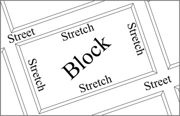
Figure 1.
Representation of a block limited by four stretches in the urban area.
After auditing the selected evaluation unit, its level of accessibility is determined based on the result of the multiplication of the assigned scores (Equation 1), varying from 0 to 1. The mathematical expression was constructed in such a way that one condition of total inaccessibility is sufficient to indicate that the unit is unusable (AWS = 0), independently of the other indicators.
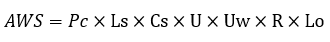 (1)
(1)where: AWS is the Accessibility of Walkable Spaces index; Pc, Ls, Cs, U, Uw, R and Lo are the scores assigned in the technical audit for the indicators Path construction, Longitudinal slope, Cross slope, Unlevel, Unobstructed width, Road crossing facility, and Landscape ornamentation, respectively.
Then, the accessibility condition for the evaluation unit can be determined based on the index values. For A condition, all indicators should have a maximum score (1 point). The AR condition occurs when there are no inaccessible scores (0 point), and there is at least one restriction condition (0.5 point). As the number of these scores increases, there is a proportional increase in the level of accessibility restriction (low, moderate, or high). Finally, the I condition requires at least one score equal to 0 (Table 2).
| AWS | Number of Indicators that restrict accessibility | Condition |
| 1 | 0 | A |
| 0.25 to 0.5 | 1 to 2 | ARl |
| 0.03 to 0.13 | 3 to 5 | ARm |
| 0.008 to 0.016 | 6 to 7 | ARh |
| 0 | - | I |
The A condition indicates adequacy to standardization and, therefore, to the use of infrastructure by all individuals. Constraint scenarios (ARl, ARm and ARh) infer technical inadequacy of space. In these cases, individuals with disabilities or with reduced mobility have difficulty walking or are unable to walk. The increase in the level of restriction is proportional to the complexity of the interventions demanded. The I situation indicates that everyone is unable to walk, which is an unacceptable condition.
The level of accessibility of an area composed of different evaluation units can be verified by calculating the median of the sample data. The median indicates the central tendency of the AWS values, and therefore the level of accessibility. It is not possible to perform arithmetic or weighted means of the values since the possible results represent a geometric sequence.
Instrument validation
The index was applied in a small town to validate the AWS tool. In these urban centers, walking is more important for urban mobility than the motorized modes of transport (Associação Nacional de Transportes Públicos, 2012). Thus, São Tomé town was defined as the object of study, which is located in the state of Paraná, Southern Brazil. In this place, the small distances and the lack of public transportation favor walking. São Tomé has an urban grid composed of 27 km of streets, with José Madureira and Vidigal Avenues the most important routes (Figure 2). The municipality has a territorial area of 218.6 km ² and a population estimated in 2018 in 5,700 inhabitants, approximately (IBGE, 2019).
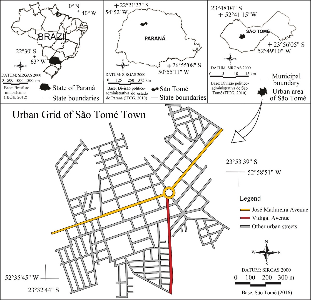
Figure 2.
Location of the urban grid of São Tomé Town, state of Paraná (IBGE, 2012; ITCG, 2010).
The town's streets design was elaborated in the 1950s by Russian engineer and surveyor Vladimir Babkov of Companhia Melhoramentos Norte do Paraná – CMNP. The project consisted of an orthogonal grid structured by two roads, José Madureira and Vidigal Avenues, connected by a central roundabout. This design aimed to accommodate the flow of vehicles to the center of the town and to connect with highways of the region. From the 1980s, there was an expansion of the territory in all directions of the initial urban design (Figure 3).
According to the Master Plan and Use and Occupation of São Tomé Soil [Plano Diretor e Uso e Ocupação do Solo de São Tomé – PDUOS] (São Tomé, 2006), the strategic instrument for urban development and expansion and orientation of the agents involved in the production and management of the town, the widths of the sidewalks of the most recently implemented areas are appropriate. Regarding José Madureira and Vidigal Avenues, the minimum width of the pavements is 3.0 m, situation in accordance with the pattern projected and implemented, also, in the initial urban design. For the new routes, the minimum limit of 2.5 m was defined, being this one the most used.
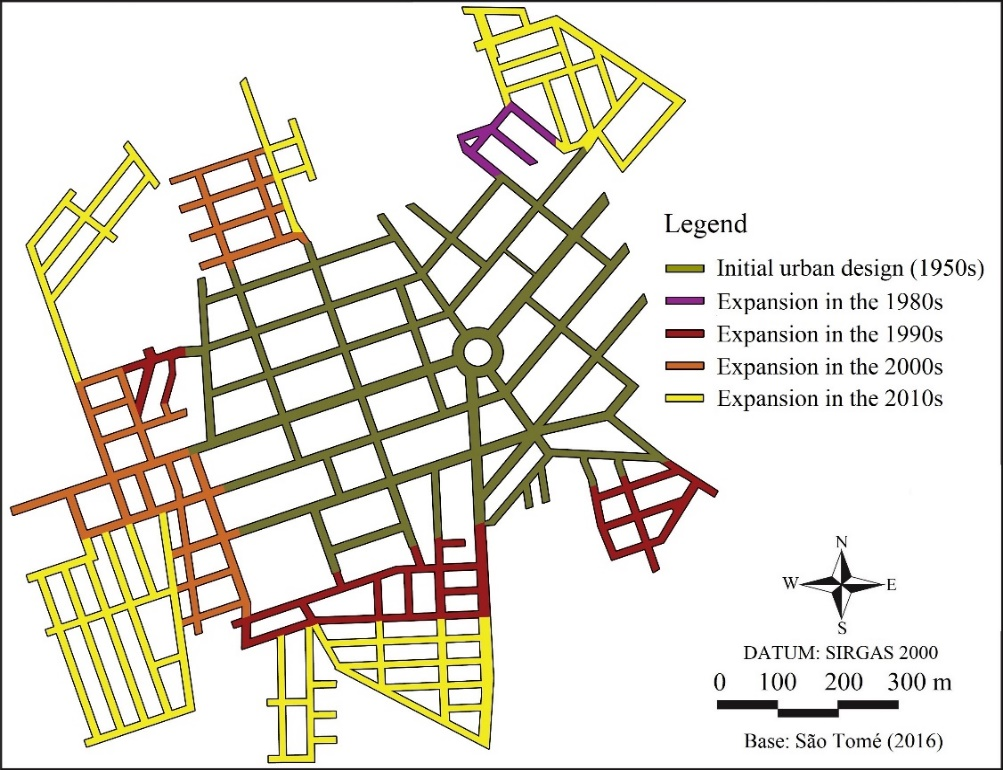
Figure 3.
Evolution of the urban grid of São Tomé Town, state of Paraná. Adapted of São Tomé (2006).
The PDUOS (São Tomé, 2006) also determines the zoning of the town, which is organized by José Madureira Avenue, which covers the entire Commerce and Services Zone (CSZ) and most of the Industrial Zone (IZ). Therefore, this avenue concentrates most of the urban equipment in its vicinity (Figure 4).
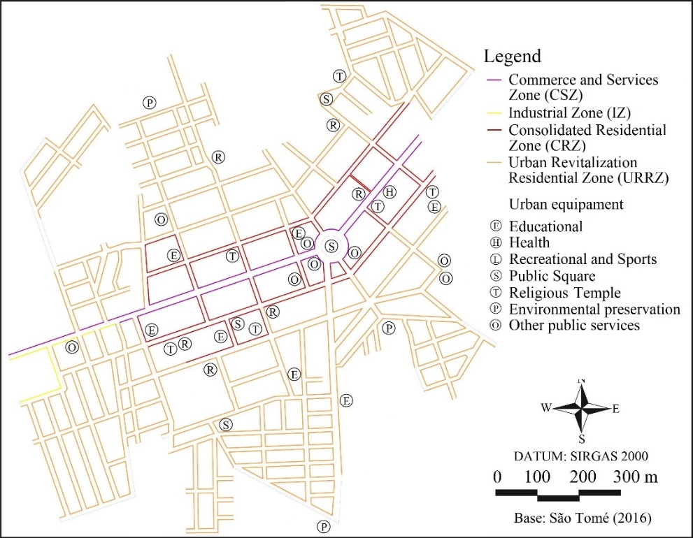
Figure 4.
Commercial, industrial and residential zoning with the indication of the location of urban equipment in São Tomé Town, state of Paraná. Adapted of São Tomé (2006).
There are two types of residential zones in the town. The first is the Consolidated Residential Zone (CRZ), adjacent to the CSZ, which is distinguished by the presence of greater infrastructure and urban equipment. As there is a greater distance to the central urban axis, the degree of consolidation decreases, forming the second typology, the Urban Revitalization Residential Zone (URRZ) (São Tomé, 2016).
On the physical aspects, in Sao Tomé town there is the occurrence of the Semideciduous Seasonal Forest and humid subtropical climate (Cfa), according to Köppen classification. The soil is flat in the central area and more rugged in the peripheral areas, with the presence of oxisols.
All stretches of sidewalks in the town were evaluated in order to demonstrate the feasibility of the index. Due to the large urban area of study, stretches of sidewalks delimited by the street corners were determined as evaluation units. The order of analysis of the stretches was defined by convenience. In the case of the Road crossing facility indicator, the Accessible condition score (1) was assigned only when there were adequate facilities at both limits of the stretch. This procedure aims to verify if the pedestrian, especially the wheelchair user, accesses and exits the sidewalk properly.
The audit was performed during the daytime period of 31 days between February 2 and May 31, 2016. The indicators related to the construction and the dimensions of the stretches received scores at the moment of the audit through the authors' observation. Measuring tape and inclinometer were used for the measurements.
The data collection procedure was different only for Landscape Ornamentation. A forest inventory was carried out to allow the floristic analysis of sidewalks trees. For this, all arboreal specimens, including palm trees (Arecaceae), and bushes with a minimum height of 1.0 meter, were considered. In some cases, photographic records were made to enable the identification of unknown species. The APG IV System (The Angiosperm Phylogeny Group et al., 2016) for the botanical families and the Tropicos database from the Missouri Botanical Garden (2019) for the specific epithets were followed. Species identifications and the association of unsuitable characteristics to specimens were based on data from the Herbarium of the Federal University of Technology – Paraná, Campo Mourão Campus (HCF).
Other means of accessing the information needed at this stage can be used, such as consultation of forest professionals and technical manuals of urban forestry.
After the audit, the value of the AWS index was calculated for each segment. Then, the level of accessibility according to the municipal zoning was determined, based on the values of the medians. Kruskal-Wallis test (H test) and Dunn test for multiple comparisons were used to investigate whether the accessibility conditions are unequal for the different land uses (decision level α = 0.05), the. Thus, it was possible to validate the results based on the information contained in the PDUOS (São Tomé, 2006).
Results and discussion
Conduct of technical audit
According to the specifications of the indicators, the accessibility conditions of 570 stretches destined to pedestrian circulation were evaluated, corresponding to 47,256 m of paths. Table 3 expresses the number of stretches in each accessibility category evaluated.
| Indicator | Stretches by condition | ||
| A | AR | I | |
| Path construction | 53 | 232 | 285 |
| Longitudinal slope | 252 | 318 | - |
| Cross slope | 73 | 497 | - |
| Unlevel | 106 | 464 | - |
| Unobstructed width | 109 | 135 | 326 |
| Road crossing facility | 80 | 490 | - |
| Landscape ornamentation | 417 | 153 | - |
Among the indicators evaluated, Path construction presented the least number of passages with A conditions (n = 53; f = 9.3%). This result shows a lack of technical criteria in the selection of material for sidewalk's surface construction and maintenance, a scenario often observed in the peripheral areas of the town. However, problems were also found in the central areas, where the use of Interlocking concrete block pavement with beveled edges was observed. It restricts the level of accessibility of wheelchair users due to the trepidation caused.
The Longitudinal slope indicator exhibits the second greatest number of accessible stretches (n = 252; f = 44.2%). It was influenced by the urban layout, often perpendicular to the contours, as per constructive aspects. In addition, discontinued sidewalks in front of lots were noted, which frequently follows the leveling of the grade of the buildings installed at different levels. The construction of ramps and the provision of rest areas are possibilities to solve the problem, however, each case must be evaluated in order to define the most adequate solution.
In the forest inventory, 4,081 individuals belonging to 73 species and 29 families were listed. Of these, 330 specimens divided into 31 distinct species presented some inadequate characteristic (Table 4). This indicated Accessibility Restriction situations in 153 stretches (f = 26.8%).
| Family | Specie | n | f | Inadequate characteristics |
| Fabaceae | Tipuana tipu (Benth.) Kuntze | 44 | 1.08% | Roots that damage the pavement |
| Rutaceae | Citrus limon (L.)Burm. f. | 38 | 0.93% | Thorns on trunk |
| Verbenaceae | Duranta erecta L. | 35 | 0.86% | Toxic fruits (Ahmed, Mohamed, El-Dib, & Hamed, 2009) |
| Anacardiaceae | Mangifera indica L. | 31 | 0.76% | Toxic latex (Flores, Canto-Aviles, & Flores-Serrano, 2001) |
| Anacardiaceae | Schinus molle L. | 24 | 0.59% | Allergic pollen (Cariñanos & Casares-Porcel, 2011) |
| Fabaceae | Paubrasilia echinata (Lam.) Gagnon, H.C. Lima & G.P. Lewis | 20 | 0.49% | Thorns on trunk |
| Apocynaceae | Nerium oleander L. | 16 | 0.39% | Plant-wide toxicity (Biondi, Leal, & Schaffer, 2008) |
| Fabaceae | Delonix regia (Boojer ex Hook.) Raf. | 16 | 0.39% | Roots that damage the pavement |
| Oleaceae | Ligustrum lucidum W. T. Aiton | 14 | 0.34% | Roots that damage the pavement; toxic fruits and leaves (Biondi et al., 2008) |
| Rutaceae | Citrus reticulata Blanco | 14 | 0.34% | Thorns on trunk |
| Fabaceae | Holocalyx balansae Micheli | 10 | 0.25% | Toxic leaves (Ló & Duarte, 2011) |
| Anacardiaceae | Schinus terebinthifolia Raddi | 9 | 0.22% | Allergic pollen (Cariñanos & Casares-Porcel, 2011) |
| Bignoniaceae | Spathodea campanulata P. Beauv. | 9 | 0.22% | Toxic flowers (Biondi et al., 2008) |
| Cupressaceae | Cupressus lusitanica Mill. | 7 | 0.17% | Allergic pollen (Cariñanos & Casares-Porcel, 2011) |
| Fabaceae | Erythrina variegata L. | 7 | 0.17% | Thorns on trunk |
| Arecaceae | Phoenix roebellenii O’Brien | 6 | 0.15% | Thorns on trunk |
| Moraceae | Ficus auriculata Lour. | 5 | 0.12% | Roots that damage the pavement |
| Apocynaceae | Plumeria rubra L. | 4 | 0.10% | Toxic latex (Biondi et al., 2008) |
| Fabaceae | Leucaenaleucocephala (Lam.) de Wit | 4 | 0.10% | Toxic leaves and bark (Dalzell, Burnett, Dowsett, Forbes, & Shelton, 2012) |
| Moraceae | Ficus benjamina L. | 4 | 0.10% | Roots that damage the pavement; toxic latex (Biondi et al., 2008) |
| Anacardiaceae | Anacardium occidentale L. | 2 | 0.05% | Toxic leaves and fruits (Flores et al., 2001) |
| Cycadaceae | Cycas circinalis L. | 2 | 0.05% | Toxic fruits and allergic pollen (Cariñanos & Casares-Porcel, 2011) |
| Araucariaceae | Araucaria angustifolia (Bertol.) Kuntze | 1 | 0.02% | Sharp leaves |
| Arecaceae | Acrocomia totai Mart. | 1 | 0.02% | Thorns on trunk |
| Arecaceae | Caryota urens L. | 1 | 0.02% | Toxic roots and fruits (Srivastav, Singh, Manimegalai, & Rajeswari 2015) |
| Cycadaceae | Cycas revoluta Thumb. | 1 | 0.02% | Allergic pollen (Cariñanos & Casares-Porcel, 2011) |
| Fabaceae | Erythrina speciosa Andrews | 1 | 0.02% | Thorns on trunk |
| Lythraceae | Punica granatum L. | 1 | 0.02% | Toxic bark (Biondi et al., 2008) |
| Meliaceae | Melia azedarach L. | 1 | 0.02% | Toxic fruits and leaves (Flores et al., 2001) |
| Nyctaginaceae | Bougainvillea glabra Choisy | 1 | 0.02% | Thorns on trunk |
| Rutaceae | Citrus sinensis L. Osbeck | 1 | 0.02% | Thorns on trunk |
| Total | 330 | 8.05% |
Results for the cross slope were considerably worse than the longitudinal slope conditions, given that 497 stretches (87.2%) presented slope greater than 3%. Adjustments for vehicle access to residences and commercial establishments, invading the area of people circulation, were the most recurrent causes of accessibility restrictions. According to the ABNT NBR 9.050:2015 (ABNT, 2015), these areas require interventions, considering that such adjustments should always be built within the lots or, in the case of sidewalks larger than 2.00 m wide, in the access areas to the lots.
Similar to the Cross-slope indicator, the Unlevel indicator presented a restriction condition for accessibility in 464 stretches (f = 81.4%). In the same way for longitudinal slopes difficulty, ramps can be used to correct the problem, as well as the regularization of the adjustments made for entry and exit of vehicles.
Conditions of inaccessibility due to barriers were found in 326 stretches of sidewalks (f = 57.2%). Construction residues on the sidewalks, as well as urban equipment and tables placed along the stretches by cafes, restaurants, and bars, were observed. Inspection activities of the Local Government become essential to guarantee the width demanded by the citizens.
Regarding Road crossing facility, the existence of ramps for people in wheelchairs was shown in 80 stretches (f = 14%). In the more recent neighborhoods, the situation was more favorable, especially in those located in the southern and northeastern regions of the town, as well as in the José Madureira and Vidigal Avenues. The installation of ramps at all intersections is essential for users, otherwise, many may be exposed to situations of conflict with vehicles.
To promote security and accessibility for citizens, inappropriate specimens should be replaced by proper ones through a specific plan. Although not standardized, it is advisable to also observe characteristics such as the compatibility of the natural architecture of the plants with the unobstructed path, the production of large or abundant fleshy fruits (considering the possibility of accidents due to the fall and to the floor becoming slippery), and the existence of legal or environmental impediments (see Silva et al., 2019).
Definition of accessibility levels for walkable spaces
The AWS values for the stretches and their respective conditions of accessibility were determined by Equation (1).Table 5 presents the number of stretches and lengths for each condition, and their locations in the urban grid are shown in Figure 5.
| Condition | Number of stretches | Total length |
| A | 1 | 95 m |
| ARl | 58 | 7,731 m |
| ARm | 149 | 7,908 m |
| ARh | 31 | 3,013 m |
| I | 331 | 28,509 m |
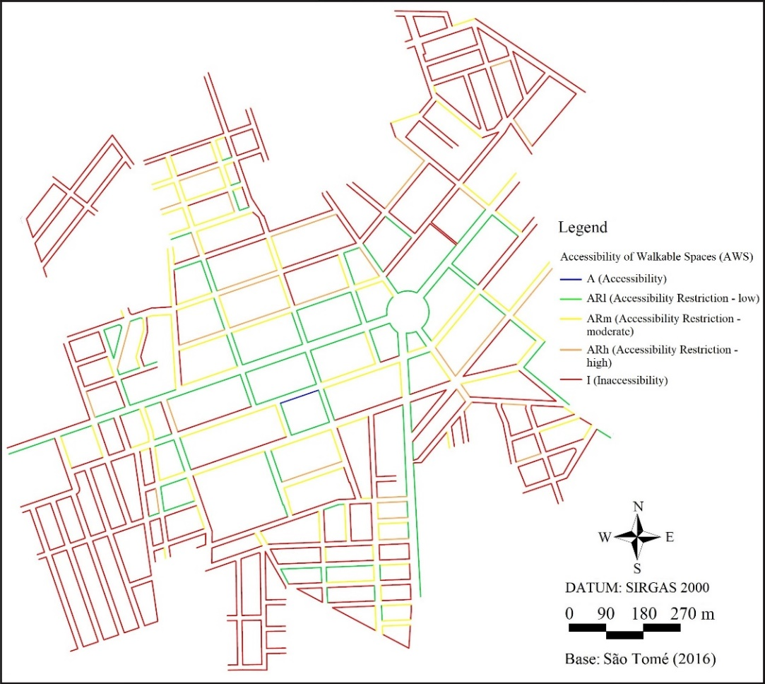
Figure 5.
Accessibility condition in the walkable stretches of São Tomé Town, state of Paraná.
Only one stretch out of the total of 570 audited was classified as A condition (AWS = 1). Therefore, this segment can be transited by all citizens and compose an accessible route. Accessibility Restrictions (ARl, ARm and ARh) corresponded to 238 stretches, which represents 18,652 m of paths (39.5% of the infrastructure for pedestrians). Amidst the AR situations, the ARm was the most frequent (f = 16.74%). In these stretches, persons without reduced mobility are able to walk. However, there are more difficulties as the restrictions are aggravated. Persons with mobility restrictions may use some of these spaces. However, these persons may have to walk on the roadway due to the sidewalk problems.
The I condition was the most recurrent (AWS = 0), corresponding to 60.3% of the stretches (28,509m of paths). Due to unobstructed widths below what is required by standardization and the occurrence of unusable or non-existent pavements, these paths are unfeasible to be accessed by the entire community.
Analyzing the level of accessibility expressed in urban zoning, according to standards, the central tendency for CSZ and IZ was the ARl condition (AWS = 0.25), and for CRZ the trend is that the accessibility of the stretches decreases to the ARm category (AWS = 0.06). For the URRZ, the stretches tended to be inaccessible (AWS = 0).
In order to determine if the accessibility conditions are unequal for the different land uses and assuming that the statistical samples do not present normality, the non-parametric H test was applied. The H statistic returned a value of 79,899, very significant (p < 0.001), thus it can be inferred that the Zones have different levels of accessibility. Also, comparing the average of the stations by Dunn method, there is a statistical significance (p < 0.05) when URRZ is compared to CRZ and CSZ, which indicates that the latter two areas are more accessible.
These results validate the information reported in the PDUOS (São Tomé, 2006) that the more consolidated areas show better quality paths. The fact that property owners are responsible for the construction may have influenced this situation. Since the land value in the central area is higher in the town, it is expected that the consolidated area's residents become more enthusiastic to invest in sidewalks. Also, as these areas present mostly occupied properties, it is more common for the citizen to invest in the construction of the sidewalk, which occurs less frequently in the case of empty lots.
Due to the consolidation phase, in many cases, the performance of the most recent occupation areas was also influenced by the fact that constructed sidewalks were used to store construction materials. Although, accessible scores were assigned in the outside areas of the initial urban design, high lighting the south and north areas. This reveals that improving accessibility is possible in any area of the town.
Municipal Government actions are fundamental to guarantee the interests of the community related to accessibility. Through public awareness strategies, inspection, technical assistance and development of public policies it is possible to facilitate the improvement of walkable areas. These actions are notably important to assist the most vulnerable segments of the population, who may have financial difficulties to build sidewalks in front of their properties.
Conclusion
The AWS index determined, based on technical standardization, the accessibility conditions of all 570 sidewalks stretch in an urban center. Results showed that 60.33% out of the 47,256 m evaluated in the study are inaccessible. However, in the most consolidated central areas, low to moderate accessibility restrictions tended to occur.
Results showed that the proposed evaluation method is adequate. However, there are some considerations for a future application of the tool. Proper technical support is required to determine the correct score for the Landscape ornamentation indicator. The AWS tool user should decide the most feasible strategy for obtaining the necessary information, such as consulting technical information material or environmental professionals. Floristic analysis is essential and deserves the attention of the Municipality to public spaces for technical and environmental compliance.
In addition, once the model uses the median of index values of different unit evaluations for a larger area of analysis of accessibility, such units must be defined in order to present homogenous characteristics. This is important because the concomitant analysis of small sidewalk stretches in front of lots with other stretches of entire blocks, or with very disparate lengths, for example, may end in inconsistent and unreliable results.
If used properly, the AWS can be a potential tool to support the decision-making of managers and urban planners to promote accessible and more inclusive urban spaces for citizens. It can be used for the requalification of built sidewalks and in projects of new developments.
Considering the influence of ISO 21542: 2011 (ISO, 2011) in ABNT NBR 9.050: 2015 (ABNT, 2015), the qualification model of this research can be used in other non-Brazilian locations. To this end, it must be adapted to suit local legal and technical specificities.
Acknowledgements
This study was financed in part by the National Program for the Improvement of High-Level Personnel (CAPES) - Finance Code 001.
References
Ahmed, W. S., Mohamed, M. A., El-Dib, R. A., & Hamed, M. M. (2009). New triterpene saponins from Durante ripens Linn. and their cytotoxic activity. Molecules, 14(5), 1952-1965. DOI: 10.3390/molecules14051952
Asadi-Sheraki, Z., Moeinaddini, M., & Shah, M. Z. (2015). Pedestrian safety index for evaluating street facilities in urban areas. Safety Science, 74(1), 1-14. DOI: 10.1016/j.ssci.2014.11.014
Associação Brasileira de Normas Técnicas [ABNT]. (2015). NBR 9.050: Acessibilidade a edificações, mobiliário, espaços e equipamentos urbanos. Rio de Janeiro, RJ.
Associação Nacional de Transportes Públicos. (2012). Sistema de informações da mobilidade urbana: Relatório geral 2011. São Paulo, SP.
Biondi, D., Leal, L., & Schaffer, M. (2008). Aspectos importantes das plantas ornamentais em escolas públicas estaduais da cidade de Curitiba, PR. Revista Brasileira de Ciências Agrárias, 3(3), 267-275. DOI: 10.5039/agraria.v3i3a325
Brasil. (2015). Lei n. 13.146, de 6 de julho de 2015. Institui a Lei Brasileira de Inclusão da Pessoa com Deficiência (Estatuto da Pessoa com Deficiência). Brasília, DF.
Cariñanos, P., & Casares-Porcel, M. (2011). Urban green zones and related pollen allergy: A review. Some guidelines for designing spaces with low allergy impact. Landscape and Urban Planning, 101(3), 205-214. DOI: 10.1016/j.landurbplan.2011.03.006
Dalzell, S. A., Burnett, D. J., Dowsett, J. E., Forbes, V. E., & Shelton, H. M. (2011). Prevalence of mimosine and DHP toxicity in cattle grazing Leucaena leucocephala pastures in Queensland, Australia. Animal Production Science, 52(5), 365-372. DOI: 10.1071/AN11236
Dixon, L. B. (1996). Bicycle and pedestrian level-of-service performance measures and stardards for congestion management systems. Transportation Research Record, 1538(1), 1-9. DOI: 10.3141/1538-01
Dowling, R., Flannery, A., Landis, B., Petritsch, T., Rouphail, N., & Ryus, P. (2008). Multimodal level of service for urban streets. Transportation Research Record, 2071(1), 1-7. DOI: 10.3141/2071-01
Ferreira, M. A. G., & Sanches, S. P. (2001). Índice de Qualidade das Calçadas – IQC. Revista dos Transportes Públicos, 1(91), 47-60.
Ferreira, M. A. G., & Sanches, S. P. (2007). Proposal of a sidewalk accessibility index. Journal of Urban and Environmental Engineering, 1(1), 1-9. DOI: 10.4090/juee.2007.v1n1.001009
Flores, J. S., Canto-Aviles, G. C. O., & Flores-Serrano, A. G. (2001). Plantas de la flora yucatanense que provocan alguna toxicidad en el humano. Revista Biomédica, 12(2), 86-96. DOI: 10.32776/revbiomed.v12i2.261
Instituto de Terras, Cartografia e Geologia do Paraná [ITCG]. (2010). Divisão político-administrativa do Paraná. Curitiba, PR.
International Organization for Standardization [ISO]. (2011). ISO 21542:2011: Building construction - Accessibility and usability of the built environment. Geneva, SW.
Instituto Brasileiro de Geografia e Estatística [IBGE]. (2012). Base Cartográfica Digital Integrada ao Milionésimo – bCIMd. Rio de Janeiro, RJ.
Instituto Brasileiro de Geografia e Estatística [IBGE]. (2019). IBGE Cidades, São Tomé – PR. Rio de Janeiro, RJ. Retrieved on Sep. 10, 2019 from https://cidades.ibge.gov.br/brasil/pr/sao-tome
Kadali, R. B., & Vedagiri, P. (2015). Evaluation of pedestrian crosswalk level of service (LOS) in perspective of type of land-use. Transportation Research Part A, 73(1), 113-124. DOI: 10.1016/j.tra.2015.01.009
Keppe Júnior, C. L. G. (2008). Formulação de um indicador de acessibilidade das calçadas e travessias. Pós, 15(24), 144-161. DOI: 10.11606/issn.2317-2762.v0i24p144-161
Khisty, C. J. (1994). Evaluation of pedestrian facilities: beyond the level-of-service concept. Transportation Research Record, 1438(1), 45-50.
Lamit, H. B., Shafaghat, A., Majid, M. Z., Keyvanfar, A., Ahmad, M. H. B., & Malik, T. A. (2013). The Path Walkability Index (PAWDEX) model: to measure built environment variables influencing residents' walking behavior. Advanced Science Letters, 19(10), 3017-3020. DOI: 10.1166/asl.2013.5066
Ló, S. M. S., & Duarte, M. R. (2011). Morpho-anatomical study of the leaf and stem of pau-alecrim: Holocalyx balansae. Revista Brasileira de Farmacognosia, 21(1), 4-10. DOI: 10.1590/S0102-695X2011005000015
Missouri Botanical Garden. (2019). Tropicos. Retrieved on Sep. 10, 2018 from http://www.tropicos.org/
Mori, M., & Tsukaguchi, H. A. (1987). A new method for the evaluation of level of service in pedestrian facilities. Transportation Research, 21A(3), 223-234. DOI: 10.1016/0191-2607(87)90016-1
São Tomé. (2006). Plano Diretor e Uso e Ocupação do Solo de São Tomé. São Tomé, PR.
São Tomé. (2016). Planta Geral da Cidade (arquivo de imagem do autor).
Silva, O. H., & De Angelis Neto, G. (2019). Índice de Serviço das Calçadas (ISC). Ambiente Construído, 19(1), 221-236. DOI: 10.1590/s1678-86212019000100303
Silva, O. H., Locastro, J. K., Sanches, S. P., De Angelis Neto, G., De Angelis, B. L. D., & Caxambu, M. G. (2019). Avaliação da arborização viária da cidade de São Tomé, Paraná. Ciência Florestal, 29(1), 371-384. DOI: 10.5902/1980509824889
Singh, R. (2016). Factors affecting walkability of neighborhoods. Procedia - Social and Behavioral Sciences, 216, 643-654. DOI: 10.1016/j.sbspro.2015.12.048
Srivastav, A. K., Singh, R., Manimegalai, S., & Rajeswari, V. D. (2015). Identification of flavonoids in methanolic extract of Caryota urens (fish tail palm): A phytochemical screening involving structure analysis by FTIR spectroscopy. Research Journal of Phytochemistry, 9(3), 127-136. DOI: 10.3923/rjphyto.2015.127.136
Talavera-Garcia, R., & Soria-Lara, J. A. (2015). Q-PLOS, developing an alternative walking index. A method based on urban design quality. Cities, 45(1), 7-17. DOI: 10.1016/j.cities.2015.03.003
The Angiosperm Phylogeny Group, Chase, M. W., Christenhusz, M. J. M, Fay, M. F., Byng, J. W., Judd, W. S., … Stevens, P. F. (2016). An update of the Angiosperm Phylogeny Group classification for the orders and families of flowering plants: APG IV. Botanical Journal of the Linnean Society, 181(1), 1-20. DOI: 10.1111/boj.12385
Tong, X., Wang, Y., & Chan, E. H. W. (2016). International research trends and methods for walkability and their enlightenment in China. Procedia Environmental Sciences, 36(1), 130-137. DOI: 10.1016/j.proenv.2016.09.023