Arquitetura e Urbanismo
Reconsidering green belts, green wedges and greenways
Reconsidering green belts, green wedges and greenways
Acta Scientiarum. Technology, vol. 43, e55196, 2021
Universidade Estadual de Maringá
Recepción: 11 Agosto 2020
Aprobación: 29 Octubre 2020
Abstract: Facing accelerated urbanization and landscape alteration, cities expand on the territory showing better or worse relationships between built environment and green spaces. Based on recent literature review, this article discusses the green wedges, green belts and greenway planning models in order to evaluate their capability in answering contemporary ecological and social issues. The article presents a conceptual overview of the selected planning models through a recent literature review, looking at the fundamental concepts of green infrastructure; then, it enlightens the connections between the spatial forms and the functions derived of these forms. These three models are connected infrastructures, varying between the ring, the star or linear forms. What differs the most is the capacity to encompass existing patches like forests or other valuable areas and the proximity and distribution of green spaces throughout the city. Whilst green belts, for their fringe condition, distance itself from the majority of inner-city dwellers, both green wedges and greenways can cross the urban fabric, and reach a greater number of neighborhoods, although the simple existence of these features does not guarantee their social functions. These findings have significant implications for the design of city expansions and can help to configure better neighborhoods in growing cities.
Keywords: Green belts, green wedges, greenways, green spaces, green infrastructure, urban form.
Introduction
The world is now facing an unprecedented transformation brought about by population growth, accelerated urbanization and consequent landscape alteration. As cities expand on the territory, they tend to expel non-human species, increase the amount of impervious surfaces and fragment natural areas (Johnson & South, 2017). Places for nature in cities are, then, reduced to remaining open spaces. There is sufficient evidence in support of the multiple-benefits of urban green spaces (Van Den Berg et al., 2015). They have the potential of homing multiple environmental and ecological functions such as protecting water resources, enhancing biodiversity, sequestering carbon, ameliorating microclimate and supplying food. At the same time, green spaces are also critical in meeting cultural and health needs of residents by providing recreational spaces, preserving historic landscapes and enhancing the aesthetic of neighborhoods. These various functions, also called ecosystem services, need to be considered simultaneously and to be balanced (Lovell & Taylor, 2013). Yet, there is still a need to further understand how to morphologically spatialize green areas in cities in order to locate an increasing number of dwellers while maintaining or promoting livable and sustainable environments (Lemes de Oliveira, 2019).
As Whitehand (2017) points out, studies of urban green spaces come mainly from biosciences, and rarely define the differences between types of green spaces. In the urban morphology field, some green space typologies are well studied within the historic-geographical and morphological period approaches, but only those linked to the urban fringe belts (MRG Conzen, 1960; MP Conzen, 2009; Meneguetti & Costa, 2015). Despite such limited scope, an ecological approach was initiated with Hopkins’ studies of the fringe belts (Hopkins, 2012). The need for greater convergence between urban form and landscape ecology has already been raised (Marcus & Pont, 2020; Jabareen, 2006), however, few attempts have been made to address it from the perspective of the geometry and form of large-scale green spaces in cities.
This article aims to contribute to the field by reviewing how the geometry of large-scale green spaces offers intrinsic potentialities and drawbacks in regards to the distribution of urban green spaces and their adequacy to address socio-ecological issues in cities. The large-scale green planning models which are the object of this study are: green belts, green wedges and greenways. These are connected infrastructures, varying in shape between the ring, the star and the linear forms, as seen in Figure 1. The green belt has been characterized as an encircling green space used “as a way of imposing an urban-rural polarity on an in-between landscape of urban fringe suburbs and ribbon development” (Amati, 2008, p.3). In turn, green wedges are ducts of green space radially distributed within the urban fabric, acquiring a myriad of characteristics and functions (Lemes de Oliveira, 2014;2019). For instance, green wedges can be stretches of natural landscapes, countryside lanes within the city and spaces for wildlife (Sturzaker & Mell, 2016). The greenways have been conceptualized as linear elements which are planned, designed and managed for multiple purposes (Ahern, 1995), and configure a form that often requires less physical space than traditional and non-linear parks (Smith & Hellmund, 1993).
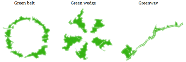
Figure 1. Diagram of the form of green space planning models
There is a growing number of studies about green infrastructure, which is defined by the European Commission as “a strategically planned network of natural and semi-natural areas with other environmental features designed and managed to deliver a wide range of ecosystem services” (European Comission [EC], 2013). The term is increasingly used in discussions of land conservation and urban development worldwide, acquiring different meanings depending on the context in which it is used. Benedict and McMahon's (2006) for instance define it as an interconnected network of natural areas and other open spaces that conserves values and functions of the natural ecosystem, sustains clean air and water, and provides a wide range of benefits to people and wildlife. Green infrastructure, in general, differs from conventional approaches to land conservation and resource protection because it leads to conservation in conjunction with urbanization and anthropogenic infrastructure planning. Unlike other conservation methods taken independently or in opposition to urbanization, green infrastructure planning recognizes the need for places for people to live, work, buy, and enjoy nature. Thus, it facilitates development in order to optimize land use to meet the needs of people and nature (Benedict & McMahon, 2006; Meneguetti, 2009). Using the background of landscape ecology, sustainable urban development, ecological corridors, and sustainable water management, green infrastructure planning facilitates human-environmental interactions and implementation at various scales (Mell, 2010).
Concerning the form that green infrastructure should take, this article is supported by the idea of design as a boundary concept between science and practice, as Nassauer and Opdam (2008) defend, with landscape ecology acting at the edge of this boundary. The roles of landscape ecology in the context of green infrastructure planning have been well defined in the literature. Landscape ecology strengthens the theoretical basis of ecology by enabling planners and ecologists to understand land in terms of relationships. The concepts of patches-corridors-matrix (Forman & Godron, 1986) and greenways (Smith & Hellmund, 1993 and Fábos & Ahern, 1995), established the importance of open spaces as places of natural processes in the city. Moreover, the quality, quantity and distribution of the open spaces in the city directly affect the performance of green infrastructure. The amount of green spaces and their distribution throughout the urban fabric are key contributors to cultural ecosystem services (Xiu N. et al., 2017). Regardless of variants in definition, landscape connectivity is a crucial characteristic of green infrastructure. Connectivity affects the flow of energy, materials, nutrients, species, and people across a landscape (Ahern, 2007). It is the key principle of spatial organization for assuring a better opportunity for providing ecosystem services, which can affect urban hydrology, mobility, recreation, and cultural assets. Furthermore, the functional and spatial connectivity of the open spaces is critical to maintaining the ecological role of mitigating and adapting to climate change and increasing the value of ecosystems services, including the ones related to health and recreation (Ahern, 2013).
Formal strategies such as green belts, green wedges and greenways can counteract spatial fragmentation, while delivering green and open spaces near residents and connect them to rural areas (Lafortezza, Davies, Sanesi, & Konijnendijkm, 2013). This article focuses on such approaches. Firstly, it presents the methodology employed for this study and the findings of the literature review. The second part presents a discussion of the connections between the selected spatial forms and their functions in light of such findings. The article ends reflecting on the potential of such large-scale green planning models in delivering green spaces in urban environments.
Methods
Green belts, green wedges and greenways have been applied for at least the last hundred years, with greater or lesser degrees of assessment and evaluation, and there is a recent surge in attention to these models in academia and in planning practice. This study reviews how their intrinsic spatial characteristics have been recently considered by the literature in their suitability or inappropriateness to balance urbanization and nature in cities.
For the purpose of this analysis, academic texts were considered from a number of databases including the Discovery service (i.e. Scielo, Science Direct and Scopus). The search included journals, books, e-books, conference materials and dissertations. Keywords included ‘green belt, ‘green wedge’ and ‘greenway’, one in each search, along with the time limit of 2008-May to 2018. A total of 185 outputs were identified concerning green belts; 12 for green wedges; and 197 for greenways. Subsequently, the results were further screened and selected considering geographic location - the UK, Europe and the USA. Only articles with a focus on the implications of form and with relevance to ecological and social issues, rather than biological or climate evaluation, were selected. Subsequently, 63 publications were finally selected for the review, 29 dealing with greenbelts, 11 with green wedges and 34 with greenways.
The texts were analysed looking for advantages and drawbacks of these green space planning models. The most relevant themes revealed by the literature were then utilized as criteria for the scrutiny of each model. They are: proximity and accessibility, relationship with the territory and size. From the systematization of the attributes some guidelines could be drawn for the spatialization of green spaces into the cities.
Results
Different greenspace policies and planning strategies were tested throughout the twentieth century. Table 1 shows an overview of the main benefits and constraints of green belts, green wedges and greenways presented in the literature over the last ten years. Taken together, these results suggest that there is an association between the form and the urban function of green spaces, despite the differences in context. A critical summary is presented below. Only attributes specifically relating to spatial concepts were included.
The green belt and the green wedge models were conceived as planning tools to manage, control and direct urban sprawl (Amati, 2008; Sturzaker & Mell, 2016; Lemes de Oliveira, 2017). Both models have positive and negative attributes considering urban expansion, while greenways do not exactly focus in managing sprawl. Although not the main subject of this study, the searched literature showed that at the metropolitan or regional scale, green belts, although being the most effective element of spatial planning (Zepp, 2018; Amati & Taylor, 2010), do not constrain suburbanization and result in leapfrogging when the area determined to expansion is not enough, with consequent long-distance commuting and increased car use (Siedentop et al., 2016; Sturzaker & Mell, 2016; Falk, 2017; Amati & Taylor, 2010; Alexandre, 2013). Although green belts, for making the rural-urban edge distinct and hence easier to manage and control (Hecimovich, 2008), can induce infill and increasing density in existing urban fabric (Siedentop et al., 2016), green wedges could be considered a more adequate solution for cities in expansion, as they do not constrain growth and bring green spaces to the inner parts of the city. At the city scale, green wedges provide a better solution to expansion areas, while green belts, by preventing new developments, sacrifice outwards growth and potential new intra-urban green spaces in favour of ‘holding the line’ at the urban-rural fringe (Lazzarini, 2018; Gant et al., 2011; Daniels, 2010; Amati & Taylor, 2010).

Differences among the three models regarding multifunctionality are often related to the distribution of open spaces through the city. For instance, the filtration of air pollutants, enhancement of microclimate and noise regulation are directed related to the location of green spaces. In this sense, green wedges, or greenways if considered as part of a system, are the most responsible forms (Sturzaker & Mell, 2016), as they are more flexible to relate to the built-up areas.
A multi-scale approach is required to fulfilling a strong multifunctional green infrastructure plan (Lovell & Taylor, 2013). The interconnection of different scales can maximise the multiple effects of the green space systems (EC, 2013). Although green infrastructure projects are carried out in Europe on a local, regional, national or trans-national scale, it is seen as paramount that there is a minimum degree of consistency and coherence across the different scales (EC, 2013).
Besides these aspects, particular spatially-related themes received significant attention by the literature. They are: proximity and accessibility, relationship with the territory and size.
The use of green spaces is directly correlated to the proximity and accessibility of residents to them. The walking distance to green spaces encourage physical activities in a daily basis, but the expected proximity can vary depending on the size and typology of green spaces (Lemes de Oliveira, 2019). In this way, the distance between housing and open spaces is a key aspect in healthy populations (Coutts, 2008, 2010). Caspersen and Olafsson (2010, p.103) emphasize the need for people to access natural landscapes for mental and physical restoration, pointing that people living in large urban areas have a probability of increased stress levels inversely proportional to the distance to green areas. Yet, the existence of open spaces does not lead per se to social inclusiveness. Many studies (e.g. Weber et al., 2017; Lindsey, 2003) show the opposite, as lower income households are often expelled with the implementation of greening strategies (Haase et al., 2017).
Regarding the relationship with the territory, the capacity to encompass natural features like water bodies, existing patches of forests, moors or other valuable areas is crucial to maintain the connectivity of the system and permit flows of energy and materials, guaranteeing the permanence of the natural values.
Quantity and size of green spaces in urban environments has increasingly been associated too with health and wellbeing (Lemes de Oliveira, 2017; Van Den Berg et al., 2015). The size of green space is related to the flexibility in land-use, and so, large open spaces provide improved conditions for public health and well-being, and to ecological services, and consequently, resilience (Hedblom et al., 2017).
The following is a comparative analysis of how the three green space planning models respond to these themes.
Green belt
The green belt is the best known green space model for its connection with the garden city idea and its diffusion throughout the 20th century. This prevalence was visible in the search, which showed the greater number of references among the three models under study.
1. Proximity and accessibility - The conceptual development of green belt encompassed providing access to open spaces for urban dwellers (Mace, 2018; Amati, 2008; Amati & Yokohari, 2006). Yet, it is especially in these respect – proximity and access - that the green belt is most criticized. For the fringe condition, it distances itself from the majority of urban dwellers. Although still protecting recreational areas from urbanization (Siedentop et al., 2006), the access to these areas is hindered by lack of proximity to potential users (Amati & Taylor, 2010, Mace, 2018), or due to the nature of uses, not always public. In the Metropolitan Green Belt in London, for example, “openness was prioritized over access and/or quality” (Mace, 2018, p.6).
2. Relationship with the territory – The green belt can protect valuable natural and agricultural areas (Siedentop et al., 2016). However, in the cases of the London and Cambridge green belts, the limits were drawn by measures (Gant et al., 2011; Morrison, 2010) paying little attention to the natural features of the territory (Amati & Yokohari, 2006). As such, there is much criticism of the protection of land with low value for nature or agriculture, while other important land is left unprotected (Falk, 2017; Thomas & Littlewood, 2010). Even so, some see green belts as responsible for enhancing the landscape (Konijnendijk, 2010).
3. Size – Green belts usually demand large areas to be protected, which are not always economic or ecologically justified. The Metropolitan Green Belt in London being three times the size of the Greater London Area or Surrey has been criticized for having more area covered by golf courses than housing (Mace, 2018). Moreover, this unbalanced relationship is questioned in face of current need for affordable housing (Amati & Taylor, 2010; Amati, 2008; Mace, 2018). Beyond size, Siedentop, Fina, & Krehl notice that housing price inflations usually happen when the green belt is located “[...] tightly around an already urbanized area” (2016, p. 72).
Green wedge
1. Proximity and accessibility - green wedges can cut cross the urban fabric and enable access to green spaces to a greater number of neighborhoods (Caspersen & Olafsson, 2010). Because of their disposition in the urban fabric, green wedges are able to bring sunlight, fresh air and vegetation to where people need them (Lemes de Oliviera, 2014). Furthermore, because of its gradually larger dimensions, the green wedge can accommodate a better diversity of activities. Since its inception the green wedge model aimed at driving large green spaces from the countryside into the core of urban settings near to where people live (Lemes de Oliveira, 2017; Frey, 2000), potentially providing a range of ecosystem services in a reasonable equitable way throughout urban areas (Sturzaker & Mell, 2016).
2. Relationship with the territory - Green wedges can be drawn as linear connections between forests and the city core, and frequently are conditioned by natural features. As such, much tend to be characterised as linear connections between patches of natural land or connective links to natural features beyond city limits (Hammond, 2014; Frey, 2000; Erixon et al., 2013). As such, they provide optimum opportunities for the definition and enhancement of ecological corridors and habitats. The spatial form of green wedges is seen as potentially the best connector for people and biodiversity, from the city core to its limits and beyond (Lemes de Oliveira, 2017).
3. Size - Green wedges can respond to the shortage of open spaces in the city core delivering functions in a gradient between green and grey (Davies, MacFarlane, McGloin, & Roe, 2015). In this way, the open spaces can widen as they distance themselves from the city center, and thus carry more functions, or be incorporated in narrower streets or boulevards in the city core. However, as the green wedge widen towards urban fringes, neighbourhoods may become isolated by these green structures if transverse connections are not sufficiently provided (Erixon et al., 2013).
Greenway
1. Proximity and accessibility - the linear configuration of greenways facilitates their distribution through the urban fabric, where they enhance quality of life by promoting opportunities for activities related to health and wellbeing and for cultural development (Weber et al., 2017; Fields et al., 2017; Larson et al., 2016; Fábos, 2004;Lackstrom & Stroup, 2009;Coutts, 2008, 2010; Pena et al., 2010; Cronan et al., 2008; Krummenacher et al., 2008).The Atlanta BeltLine is a good example of a greenway that seeks to weave the city’s districts together, maximizing easy access to a large number of residents. It has been reported that users living closer to the greenways feel more connected to the social infrastructure of the communities in which they reside (Larson et al., 2016). Even so, some researches show that minorities and lower income households have disproportionate less access to trails (Weber et al., 2017; Coutts, 2008).
2. Relationship with the territory - the greenway idea is often related to the protection of rivers and other natural sensible areas (Fábos, 2004; Quattrone et al., 2017; Krummenacher et al., 2008) and its ability to connect and protect local resources (Palmisano et al., 2016; Dal Sasso & Ottolino, 2011). The riparian vegetation filters air and water pollutants, homes wildlife and preserves natural qualities of the territory while the greenway borders can support human activities as walking, cycling and recreation. This can be seen in Olmsted’s Emerald’s Necklace in Boston, which set forth a strong backbone to the newer greenway extensions (Palazzo, 2014). In Atlanta, as the main axis is the rail line, the greenway is less natural, but, even so, it links various significant green spaces (Weber et al., 2017).
3. Size - in urban areas, where narrow corridors configured by waterways or other landscape features are the only remaining space, greenways may be the single choice for providing open spaces in high-cost urban land because they require less physical space than traditional and non-linear parks, and may include areas of lower real estate value (Smith & Hellmund, 1993). However, the corridor width is crucial to permit connectivity to support wildlife, plant life, and the hydrology of rivers and streams (Schafer, Scott, & Mixon, 2000). Many studies have found linkages between dimensions of design and physical activity, but some of the findings are inconclusive or show no relationships (Lindsey, Wilson, Yang, & Alexa, 2008).
The literature reviewed included case studies from a range of locations in Europe, the UK and the USA. These are shown in Table 2.

Figure 2 shows the prevalence of each planning model in each location. The green belt is the best known green space model for its connection with the garden city idea and its diffusion throughout the 20th century. It was implemented in fourteen British cities, but has also spread to the rest of the world, regardless of the particularities of urban growth that affect each one, with examples coming from: Frankfurt, Berlin, Vienna, Barcelona and Budapest in Europe, Washington DC, Cincinnati, Milwaukee and Chicago in the USA, Tokyo, Bangkok, Seoul, Taipei and Guangzhou in Asia, and Sydney and Melbourne in Australia (Tang, Wong, & Lee, 2007, Amati, 2008). This prevalence was visible in the search, which showed the greater number of examples among the three models being the green belt.

Figure 2. Number of examples of applied green space planning models in the literature review
With regards to green wedges, although there has been significant international attention to this model, few examples are so successfully implemented as Copenhagen (Caspersen, Konijnendijk, & Olafsson, 2006) and Stockholm (Erixon et al., 2013), the cities that are mentioned whenever the model is discussed.
The examples of greenways come primarily from American cities or regions. In Europe, most of greenways planned are parkways connecting open spaces with a focus on non-motorized transport (Turner, 2006). Exceptions can be found in the Netherlands and Germany, where the greenways’ ecological function is emphasized (Toccolini, Fumagalli, & Senes, 2006).
Conclusion
The design of new urban development combining built environment with green spaces and the reintroduction of green spaces into cities are crucial challenges of the twenty-first century. This article has focused on the intrinsic benefits and limitations of the selected green space planning models and the extent to which they can enhance the presence of greenery in the urban environment.
Considering the primary goal of managing, controlling and directing urban sprawl, green belts seem to work better when areas for the expansion of the city are already incorporated into the urban fabric. They are less capable to deal with delivering spaces for recreational and physical activities near to urban dwellers and are also criticized because they often protect low value areas while leaving aside more valuable ones.
Green wedges, despite being an effective shape in the regional scale, because of the wedge configuration, can isolate neighborhoods if peripheral connections are not adequately provided. The green wedge configuration is better suitable to deliver greenspaces throughout the city for their intrinsic shape and capacity to adapt to narrow streets and boulevards in city centres and widen as it goes towards the periphery.
Both greenways and green wedges are capable to offer low distances between open spaces and residential areas for the purpose of recreation and physical activities, linked to health and community cohesion. The greenways tend to include a wider range of functions, although the main one remains the connection, whether of people, wildlife, or storm water.
From these findings it is possible to infer that the combination of the three models could cater to a larger number of functions and deliver better quality of life to inhabitants and possibility of life for other species. For instance, it is evident that local features, values and constraints are the base for planning and design, but formal models can help in decision-making when other aspects have already been addressed.
These findings have significant implications for the design of city expansions and can help configure better neighbourhoods in growing cities. The generalisability of these results is subject to certain limitations. Further research should be carried out to determine what makes the difference between the successful cases and the ones in which green spaces did not survive urban development over time.
We know that the future is green, what we do not know yet is how to guarantee the presence of green inside our cities. Greenbelts, green wedges and greenways should be the starting point.
References
Aguado, I., Barrutia, J. M., & Echebarria, C. (2013). The green belt of Vitoria-Gasteiz. A successful practice for sustainable urban planning. Boletín de la Asociación de Geógrafos Españoles, 61, 181-193.
Ahern, J. (1995). Greenways as a planning strategy. In J. G. Fábos & J. Ahern (Eds.), Greenways: The beginning of an international movement (p. 131-155). Amsterdam, NL: Elsevier Science.
Ahern, J. (2007). Green infrastructure for cities: the spatial dimension. In V. Novotny & P. Brown (Eds.), Cities of the Future: towards integrated sustainable water and landscape management (p. 267-283). London, UK: IWA Publishing.
Ahern, J. (2013). Urban landscape sustainability and resilience: the promise and challenges of integrating ecology with urban planning and design. Landscape Ecology, 28(6), 1203–1212. DOI: http://doi.org/10.1007/s10980-012-9799-z
Alexandre, F. (2013). The role of vegetation in the urban policies of European cities in the age of the sustainable city. European Spatial Research and Policy, 20(2), 11-26. DOI: http://doi.org/10.2478/esrp-2013-0008
Amati, M. (2008). Green belts: a twentieth-century planning experiment. In M. Amati (Ed.), Urban green belts in the twenty-first century(p. 1-17). Aldershot, UK: Ashgate.
Amati, M., & Taylor, L. (2010). From green belts to green infrastructure. Planning, Practice & Research, 25(2), 143–155. DOI: http://doi.org/10.1080/02697451003740122
Amati, M., & Yokohari, M. (2006). Temporal changes and local variations in the functions of London’s green belt. Landscape and Urban Planning, 75(1-2), 125–142. DOI: http://doi.org/10.1016/j.landurbplan.2004.12.007
Atlanta BeltLine Overview. (2016). Retrieved May 1, 2018 from https://bitlybr.com/hJxohdh
Benedict, M. A., & McMahon, E. T. (2006). Green infrastructure: linking landscapes and communities. Washington, DC: Island Press.
Breitling, M., & Ruland, G. (2008). The Vienna green belt: from localised protection to a regional concept. In M. Amati (Ed.), Urban green belts in the twenty-first century (167-183). Aldershot: Ashgate.
Caspersen, O. H., & Olafsson, A. S. (2010). Recreational mapping and planning for enlargement of the green structure in greater Copenhagen. Urban Forestry & Urban Greening, 9(2), 101–112. DOI: http://doi.org/10.1016/j.ufug.2009.06.007
Caspersen, O. H., Konijnendijk, C. C., & Olafsson, A. S. (2006). Green space planning and land use: an assessment of urban regional and green structure planning in greater Copenhagen. Geografisk Tidsskrift - Danish Journal of Geography 106(2), 7–20. DOI: http://doi.org/10.1080/00167223.2006.10649553
Catchpole, R. D. J. (2016). Connectivity, networks, cores and corridors. In S. J. Carver & S. Fritz (Eds.), Mappingwilderness: concepts, techniques and applications (p. 35-54). Dordrecht, NL: Springer.
Conzen, M. P. (2009). How cities internalize their former urban fringes: a cross-cultural comparison. Urban Morphology, 13(1), 29-54.
Conzen, M. R. G. (1960). Alnwick, Northumberland: a study in town-plan analysis. London, UK: Institute of British Geographers Publication.
Coutts, C. (2008). Greenway accessibility and physical-activity behaviour. Environment and Planning B: Planning and Design, 35(3), 552-563. DOI: http://doi.org/10.1068/b3406
Coutts, C. (2009). Multiple case studies of the influence of land-use type on the distribution of uses along urban river greenways. Journal of Urban Planning and Development, 135(1), 31-38. DOI: 10.1061/(ASCE)0733-9488(2009)135:1(31)
Coutts, C. (2010). Green infrastructure and public health in the Florida communities trust public land acquisition program. Planning Practice & Research, 25(4), 439-459. DOI: http://doi.org/10.1080/02697459.2010.511017
CPRE & Natural England. (2010). Green Belts in England. Key facts. Retrieved Jun 13, 2018 from https://bitlybr.com/q05U2sT
Cronan, M. K., Shinew, K. J., & Stodolska, M. (2008). Trail use among Latinos: recognizing diverse uses among a specific population. The Journal of Park and Recreation Administration, 26(1), 62-86.
Dal Sasso, P., & Ottolino, M. A. (2011). Greenway in Italy: examples of projects and implementation. Journal of Agricultural Engineering, 42(1), 29-39. DOI: http://doi.org/10.4081/jae.2011.1.29
Daniels, T. L. (2010). The use of green belts to control sprawl in the united states. Planning, Practice and Research, 25(2), 255–271. DOI: http://doi.org/10.1080/02697451003740288
Davies, C., MacFarlane, R., McGloin, C., & Roe, M. (2015). Green infrastructure planning guide. Version: 1.1 (Technical Report). Retrieved May 1, 2018 from https://www.researchgate.net/publication/265012095 DOI: http://doi.org/10.13140/RG.2.1.1191.3688
Erixon, H., Borgström, S., & Andersson, E. (2013). Challenging dichotomies – exploring resilience as an integrative and operative conceptual framework for large-scale urban green structures. Planning Theory & Practice, 14(3), 349–372. DOI: http://doi.org/10.1080/14649357.2013.813960
European Comission [EC]. (2013). Communication from the Commission to the European Parliament, the Council, the European Economic and Social Committee and the Committee of the Regions Green Infrastructure (GI) — Enhancing Europe's Natural Capital'. Retrieved Jun 15, 2018 from https://bitlybr.com/URTLk
Fábos, J. G. (2004). Greenway planning in the United States: its origins and recent case studies. Landscape and Urban Planning, 68(2-3), 321–342. DOI: http://doi.org/10.1016/j.landurbplan.2003.07.003
Fábos, J. G., & Ahern, J. (1995). Greenways. The beginning of an international movement. Amsterdam, NL: Elsevier Science.
Falk, N. (2017). Garden cities for the twenty-first century. Urban Design International, 22(1), 91-110. DOI: http://doi.org/10.1057/s41289-016-0032-6
Ferretti, V., & Degioanni, A. (2017). How to support the design and evaluation of redevelopment projects for disused railways? A methodological proposal and key lessons learned. Transportation Research Part D: Transport and Environment, 52(Part A), 29-48. DOI: http://doi.org/10.1016/j.trd.2017.02.008
Fields, B., Thomas, J., & Wagner, J. A. (2017). Living with water in the era of climate change: lessons from the Lafitte greenway in post-Katrina New Orleans. Journal of Planning Education and Research, 37(3), 309-321. DOI: http://doi.org/10.1177/0739456x16655600
Forman, R. T. T., & Godron, M. (1986). Landscape Ecology. New York, NY: Wiley.
Frey, H. (2000). Not green belts but green wedges: the precarious relationship between city and country. Urban Design International, 5, 13–25. DOI: https://doi.org/10.1057/palgrave.udi.9000003
Fumagalli, N. & Toccolini, A. (2012). Relationship between greenways and ecological network: a case study in Italy. International Journal of Environmental Research, 6(4), 903-916. DOI: http://doi.org/10.22059/IJER.2012.561
Gant, R. L., Robinson, G. M., & Fazal, S. (2011). Land-use change in the ‘edgelands’: policies and pressures in London’s rural–urban fringe. Land Use Policy, 28(1), 266-279. DOI: https://doi.org/10.1016/j.landusepol.2010.06.007
Gopinath, D., & Jackson, T. (2010). A pragmatist lens on local planning practices: the case of the St. Andrews community-driven green belt. Planning, Practice & Research, 25(2), 183–201. DOI: http://doi.org/10.1080/02697451003740197
Haase, D., Kabisch, S., Haase, A., Andersson, E., Banzhaf, E., Baró, F., ... Wolff, M. (2017). Greening cities -
Hammond, C. I. (2014). The thin end of the green wedge: Berlin’s planned and unplanned urban landscapes. In L. A. Sandberg, A. Bardekjian & S. Butt (Eds.), Urban forests, trees, and greenspace: a political ecology perspective (p. 207-223). London, UK: Routledge.
Hecimovich, J. (2008). Greenbelts or green wedges? American Planning Association, 74(3), 40-43.
Hedblom, M., Andersson, E., & Borgström, S. (2017). Flexible land-use and undefined governance: from threats topotentials in peri-urban landscape planning. Land Use Policy, 63, 523–527. DOI: http://doi.org/10.1016/j.landusepol.2017.02.022
Hopkins, M. I. W. (2012). The ecological significance of urban fringe belts. Urban Morphology, 16(1), 41-54.
Ignatieva, M., Stewart, G. H., & Meurk, C. (2011). Planning and design of ecological networks in urban areas. Landscape and Ecological Engineering, 7(1), 17-25. DOI: http://doi.org/10.1007/s11355-010-0143-y
Jabareen, Y. R. (2006). Sustainable Urban Forms. Their Typologies, Models, and Concepts. Journal of Planning Education and Research, 26, 38-52. DOI: http://doi.org/10.1177/0739456X05285119
Johnson, M. T. J., & South, J. M. (2017). Evolution of life in urban environments. Science, 358(6363), eaam8327. DOI: http://doi.org/10.1126/science.aam8327
Keith, S. J., Larson, L. R., Shafer, C. S., Hallo, J. C., & Fernandez, M. (2018). Greenway use and preferences in diverse urban communities: implications for trail design and management. Landscape and Urban Planning, 172, 47–59. DOI: http://doi.org/10.1016/j.landurbplan.2017.12.007
Kohut, S. M., Hess, G. R., & Moorman, C. E. (2009). Avian use of suburban greenways as stopover habitat. Urban Ecosystems, 12(4), 487-502. DOI: http://doi.org/10.1007/s11252-009-0099-6
Konijnendijk, C. C. (2010). The role of forestry in the development and reform of green belts. Planning Practice & Research, 25(2), 241-254. DOI: http://doi.org/10.1080/02697451003740270
Krummenacher, W. S., Swanstrom, T., & Tranel, M. (2008). Regional system of greenways: if you can make it in St. Louis, you can make it anywhere. National Civic Review, 97(2), 25-30. DOI: http://doi.org/10.1002/ncr.211
Kullmann, K. (2013). Green-networks: integrating alternative circulation systems into post-industrial cities. Journal of Urban Design, 18(1), 36–58. DOI: http://doi.org/10.1080/13574809.2012.739545
Lackstrom, K., & Stroup, L. J. (2009). Using a local greenway to study the river environment and urban landscape. Journal of Geography, 108(2), 78-89.
Lafortezza, R., Davies, C., Sanesi, G., & Konijnendijk, C. C. (2013). Green Infrastructure as a tool to support spatial planning in European urban regions. iForest - Biogeosciences and Forestry, 6(3), 102-108. DOI: https://doi.org/10.3832/ifor0723-006
Larson, L. R., Keith, S. J., Fernandez, M., Hallo, J. C., Shafer, C. S., & Jennings, V. (2016). Ecosystem services and urban greenways: what's the public's perspective? Ecosystem Services, 22, 111-116. DOI: http://doi.org/10.1016/j.ecoser.2016.10.004
Lazzarini, L. (2018). The role of planning in shaping better urban-rural relationships in Bristol city region. Land Use Policy, 71, 311-319. DOI: http://doi.org/10.1016/j.landusepol.2017.12.005
Lemes de Oliveira, F. (2014). Green wedges: origins and development in Britain. Planning Perspectives, 29(3), 357-379. DOI: http://doi.org/10.1080/02665433.2013.824369
Lemes de Oliveira, F. (2015). Abercrombie’s green-wedge vision for London: the county of London plan 1943 and the greater London plan 1944. TPR - The Town Planning Review, 86(5), 495-518. DOI: http://doi.org/10.3828/tpr.2015.30
Lemes de Oliveira, F. (2017). Green wedge urbanism: history, theory and contemporary practice. New York, NY: Bloomsbury Publishing.
Lemes de Oliveira, F. (2019). Green wedges: the resilience of a planning idea. In F. Lemes de Oliveira & I. Mell (Eds.), Planning cities with nature: theories, strategies and methods (p. 17-27). Switzerland, SW: Springer Nature.
Lindsey, G. (2003). Sustainability and urban greenways: indicators in Indianapolis. American Planning Association - Journal of the American Planning Association, 69(2), 165-180. DOI: http://doi.org/10.1080/01944360308976304
Lindsey, G., Wilson, J., Yang, J. A., & Alexa, C. (2008). Urban greenways, trail characteristics and trail use: implications for design. Journal of Urban Design, 13(1), 53–79. DOI: http://doi.org/10.1080/13574800701804033
Lovell, S. T., & Taylor, J. R. (2013). Supplying urban ecosystem services through multifunctional green infrastructure in the United States. Landscape Ecology, 28, 1447–1463. DOI: https://doi.org/10.1007/s10980-013-9912-y.
Mace, A. (2018). The metropolitan green belt, changing an institution. Progress in Planning, 121, 1–28. DOI: http://doi.org/10.1016/j.progress.2017.01.001
Marcus, L., & Pont, M. (2020). Towards a socio-ecological spatial morphology: a joint network approach to urban form and landscape ecology. Urban Morphology, 24(1), 21-34.
Matos, R. S., Calhau, R., & Lisboa, A. (2015). Greenways – an alternative mobility structure and an urban development strategy. In Proceedings of The 3rd Human and Social Sciences at the Common Conference [HASSACC] (p. 213- 218). DOI: http://doi.org/10.18638/hassacc.2015.3.1
Mell, I. C. (2010). Green infrastructure: concepts, perceptions and its use in spatial planning (Unpublished PhD Thesis, University of Newcastle, New South Wales). Recovered from http://hdl.handle.net/10443/914
Meneguetti, K. S. (2009). Cidade Jardim, cidade sustentável: a estrutura ecológica urbana e a cidade de Maringá. (Garden city, sustainable city: green infrastructure and the city of Maringá). Maringá, PR: Eduem.
Meneguetti, K. S., & Costa, S. d. A. P. (2015). The fringe-belt concept and planned new towns: a Brazilian case study. Urban Morphology, 19(1), 25-33.
Morrison, N. (2010). A green belt under pressure: the case of Cambridge, England. Planning, Practice & Research, 25(2), 157–181. DOI: http://doi.org/10.1080/02697451003740189
Nassauer, J. I., & Opdam, P. (2008). Design in science: extending the landscape ecology paradigm. Landscape Ecology, 23, 633–644. DOI: http://doi.org/10.1007/s10980-008-9226-7
Pacione, M. (2014). The power of public participation in local planning in Scotland: the case of conflict over residential development in the metropolitan green belt. GeoJournal, 79, 31-57. DOI: http://doi.org/10.1007/s10708-013-9477-y
Palazzo, A. L. (2014). The Boston greenway: form and process issues at stake. Journal of Urban Design, 19(3), 352–367. DOI: http://doi.org/10.1080/13574809.2014.890041
Palmisano, G. O., Govindan, K., Loisi, R. V., Dal Sasso, P., & Roma, R. (2016). Greenways for rural sustainable development: an integration between geographic information systems and group analytic hierarchy process. Land Use Policy, 50, 429-440. DOI: http://doi.org/10.1016/j.landusepol.2015.10.016
Pellews, R. (2012). The future of Cambridge’s green belt. 2030 vision for the Cambridge sub-region. University of Cambridge. Retrieved Jun 15, 2018 from http://www.damtp.cam.ac.uk/user/pvl/vision/6/
Pena, S. B., Abreu, M. M., Teles, R., & Espırito-Santo, M. D. (2010). A methodology for creating greenways through multidisciplinary sustainable landscape planning. Journal of Environmental Management, 91(4), 970-983. DOI: http://doi.org/10.1016/j.jenvman.2009.12.004
Quattrone, M., Tomaselli, G., Riguccio, L., & Russo, P. (2017). Assessment of the territorial suitability for the creation of the greenways networks: methodological application in the Sicilian landscape context. Journal of Agricultural Engineering, 48(4), 209-222. DOI: http://doi.org/10.4081/jae.2017.696
Sharma, A. (2015). Urban greenways: operationalizing design syntax and integrating mathematics and science in design. Frontiers of Architectural Research, 4(1), 24-34. DOI: http://doi.org/10.1016/j.foar.2014.11.002
Siedentop, S., Fina, S., & Krehl, A. (2016). Greenbelts in Germany’s regional plans - an effective growth management policy? Landscape and Urban Planning, 145, 71–82. DOI: http://doi.org/10.1016/J.LANDURBPLAN.2015.09.002
Smith, D. S., & Hellmund, P. C. (1993). Ecology of greenways: design and function of linear conservation areas. Minneapolis, MN: University of Minnesota Press.
Sturzaker, J., & Mell, I. (2016). Green Belts. Past; present; future? New York, NY: Routledge.
Tang, B.-S., Wong, S.-W., & Lee, A. K.-W. (2007). Green belt in a compact city: a zone for conservation or transition? Landscape and Urban Planning, 79(3-4), 358–373. DOI: http://doi.org/10.1016/j.landurbplan.2006.04.006
Thomas, K., & Littlewood, S. (2010). From green belts to green infrastructure? The evolution of a new concept in the emerging soft governance of spatial strategies. Planning, Practice & Research, 25(2), 203–222. DOI: http://doi.org/10.1080/02697451003740213
Toccolini, A. Fumagalli, N., & Senes, G. (2006). Greenways planning in Italy: the Lambro river valley greenways system. Landscape and Urban Planning, 76(1-4), 98–111. DOI: http://doi.org/10.1016/j.landurbplan.2004.09.038
Turner, T. (2006). Greenway planning in Britain: recent work and future plans. Landscape and Urban Planning, 76(1-4), 240–251. DOI: http://doi.org/10.1016/j.landurbplan.2004.09.035
Van den Berg, M., Wendel-Vos, W., Van Poppel, M., Kemper, H., Van Mechelen, W., & Maas, J. (2015). Health benefits of green spaces in the living environment: a systematic review of epidemiological studies. Urban Forestry & Urban Greening, 14(4), 806-816. DOI: http://doi.org/10.1016/j.ufug.2015.07.008
Weber, S., Boley, B. B., Palardy, N., & Gaither, C. J. (2017). The impact of urban greenways on residential concerns: findings from the Atlanta belt line trail. Landscape and Urban Planning, 167, 147-156. DOI: http://doi.org/10.1016/j.landurbplan.2017.06.009
Whitehand, J. W. R. (2017). Editorial comment. How we view cities: a green-space enigma? Urban Morphology, 21(2), 103-104.
Xiu, N., Ignatieva, M., van den Bosch, C. K., Chai, Y., Wang, F., Cui, T., & Yang F. (2017). A socio-ecological perspective of urban green networks: the Stockholm case. Urban Ecosyst, 20, 729-742. DOI: https://doi.org/10.1007/s11252-017-0648-3
Zepp, H. (2018). Regional green belts in the Ruhr region. A planning concept revisited in view of ecosystem services. Erdkunde, 72(1), 1-22. DOI: http://doi.org/10.3112/erdkunde.2018.01.01
Notas de autor
ksmeneguetti@uem.br