Papers
Geotourism Potentiality of Fossil Park Using Swot Matrix and Analytical Hierarchy Process (AHP) for Amkhoi Wood Fossil Park, Birbhum District, West Bengal, India
 Sajal Ghosh sajalghoshsuri@gmail.com
Vibhash Chanra Jha vcjha@asia.com
Jitendra Shukla jitendra.rnc@gmail.com
Sajal Ghosh sajalghoshsuri@gmail.com
Vibhash Chanra Jha vcjha@asia.com
Jitendra Shukla jitendra.rnc@gmail.com
Geotourism Potentiality of Fossil Park Using Swot Matrix and Analytical Hierarchy Process (AHP) for Amkhoi Wood Fossil Park, Birbhum District, West Bengal, India
Sociedade & Natureza, vol. 36, no. 1, e73588, 2024
Editora da Universidade Federal de Uberlândia - EDUFU
Received: 19 May 2024
Accepted: 11 September 2024
Published: 06 November 2024
Abstract: Geoparks are a new tourism form integrating geography and local development, focusing on geological conservation, marketing, and local culture. Geotourism Ecosystem aims to build a stronger network of geoparks. Amkhoi Wood Fossil Park in Birbhum, India, houses 20 million-year-old angiosperm wood fossils. It has been designated a Biodiversity Heritage Site, which aims to protect natural heritage, educate tourists, preserve fossils, and create jobs. Wood fossils from West Bengal, India's, Amkhoi Fossil Park are well known for offering insights into the natural history of the area. The transformation of wood into stone through the process of petrification brings to light natural occurrences such as tree falls and mineral infiltration. The most well-known fossils in the park are from the Glossopteris genus, which represents the Permian period's prehistoric vegetation. Miocene angiosperm wood fossils shed light on the ecological dynamics and evolutionary history of the area. The fossil record of the Anacardiaceae family indicates the warm, humid environment of the area. Using the Saaty scale, the study analyzed the SWOT components and used Eigenvalues to determine each factor's significance. At 54.4%, opportunities have the most weight, followed by vulnerabilities, threats, and strengths. The development of geotourism in the research area is least affected by risk factors. Each SWOT group's high local priority SWOT variables were selected. The greatest potential existed for government officials to give tourism planning more attention. Some of the weaknesses were unusual geological features, insufficient infrastructure, and low awareness. Particularly rare fossils and a geological fossil park are two of the study area's advantages.
Keywords: Geo-tourism, Fossil Park, Death of the Forest, Swot Matrix and AHP Process.
INTRODUCTION
Geoparks and geo-tourism in rural areas encourage growth, cultural sustainability, and also increasing employment and emigration involving local population in their operation (Farsaniet al., 2012). Five elements of geo-tourism are outlined by Dowling (2011) namely producing tourist satisfaction, geological basis, sustainable, informative, and locally beneficial. It encourages travel that is respectful of the environment and local culture, conservation, community service, instruction in geology, and financial support for geo-site upkeep (Datta, 2020). Geo-tourism is gaining popularity in developing nations to address environmental issues caused by overtourism, promoting sustainable development in unspoiled environments and addressing the sustainability of tourism hotspots (Das; Roy., 2019). A geological feature such as a remnant hill, karst landscape, fossil park, rock outcrop, or badland topography are examples of typical geomorphosite or geosite. Geo-tourism is a successful niche travel industry that uses natural geological features for tourism, but its sustainability is threatened by human activities (Mandal, 2021). The terms "geoheritage" and "geoconservation" refer to the preservation and conservation of earth science elements such as rock monuments and fossil parks (Ghosh et al., 2021). The best means of promoting and protecting them is geotourism, which also serves as a valuable branding tool for Paleopark and the region's sustainable socioeconomic growth (Mathur et al., 2020). Areas deemed scientifically and educationally significant for their unique fossils, unusual rock types, textbook characteristics, and other geologic attributes are referred to as geoheritage (Ramaiya, 2015).
Geoconservation strategies should include a geosites inventory for preservation and interpretation. Tourism carrying capacity is refined to ensure sustainability in tourism development. Despite a rich geological history, low geodiversity, and lack of a Global Geopark, geotourism is gaining popularity. Geosites are scientifically significant sites with potential for sustainable development, tourism, education, conservation, research, and livelihood, measured by their management and protection of geological heritage (de Lima et al., 2010; Páskováet al., 2021; Coronato; Schwarz, 2022; Sumanapala; Wolf, 2020; Dingwall et al., 2005; Suzuki; Takagi, 2018). Geotourism encompasses various tourism formats, including cultural and ecotourism. Geoconservation is a geological technique aimed at preserving natural resources and their environment, preserving well-developed geodiversity examples. Geotourism impacts city location, fortification systems, tourism, and local development. This study assesses the unique geoheritage values in the proposed Geopark Djerdap, focusing on five geosites and considering degradation risk. Geotourism is a sustainable tourism strategy that encourages geology and landscape research, conservation, and Earth sciences awareness. The study uses the SWOT-AHP method to assess Mama Bhagne Pahar, a granite hill in Birbhum District, as a geotourism destination (Woodier, 2014; Hose, 2012; Hose; Vasiljević, 2012; Kubalíková, 2014; Belijet al., 2018; Hose, 2000; Dowling, 2014; 2011; Ólafsdóttir; Tverijonaite, 2018; Amaro et al., 2023; Ghosh, 2024). Majuli River Island, the world's largest artificial island, is home to traditional arts, crafts, and dances. It is also the hub of Assamese Neo-Vaishnavite establishments and monasteries. Geomorphological landscapes and geomorphosites are crucial for geomorphological heritage and sustainable tourism. In India, there are numerous Granitic Geotouristic sites, highlighting the importance of these sites in global geoheritage (Sahariahet al., 2013; Borkakoti et al., 2017; Datta, 2020; Zgłobicki; Baran-Zgłobicka, 2013; Eshraghi et al., 2012; Migoń, 2021). Many ecotourism activities take place in protected regions, which can reap real financial benefits from ecotourism (Sahani, 2020). Current Studies on tourism are grounded in scientific principles and employs many quantitative tools and procedures (Raha et al., 2021). In Indian scenario, ecotourism is rapidly growing its graph day by day (Debnath; Saha, 2019). A significant niche market in the global tourism industry is ecotourism (Thomas, 2022). Climate change and an increase in environmental awareness have led to a growing interest in ecotourism among academics and practitioners alike. The habitats found in mountains may alter as a result of tourism (Batra, 2001).
Invertebrate, vertebrate, wood, and stromatolite fossils are among the fossils. Stromatolites are distinct structures that are made in shallow water by blue-green algae. Cell structure and original structure are preserved in wood by petrifaction or permineralization (Chakrabarty; Mandal, 2019). Visitors can gather fossils at fossil parks, which leads to the acquisition of a few fossils. Development is concentrated on six areas: tools, visitor education, identification of fossils, genuine gathering, informative websites, and accessibility. Mature is Salkhan Fossil Park (Singh, 2016). In Paleopark, geotourism fosters and preserves fossil sites, allowing for long-term socioeconomic development. Threats to these locations are identified by field studies (Mathur et al., 2020). Given the emphasis on biodiversity area inventories in the Biological Diversity Bill 2002 and the Convention on Biological Diversity, the floristic study conducted at the Ghughua Fossil Park is extremely important (Prasad Tiwari; Magesh; Rizvi, 2017). Travel-related activities have an immediate effect on the local populace as well as the environment, aligning with local goods and services (Mirari et al., 2020). Amkhoi Fossil Park in West Bengal, India, conserves sedimentary rocks and wood fossils, promoting understanding of Earth's biological and geological history (Sen, 2020). Nowadays, it has been observed that these valuable geotourism resources are under threat due to human intervention, and many of them areon the brink of being extinct forever (Mandal, 2021). Especially in regions with low economic development and high unemployment and youth migration rates, the potential of geosites still has to be discovered (Avelar et al., 2015). The known fossil record in Thailand ranges from Cambrian trilobites up to Holocene pollen. Although these fossils are considered part of the national heritage, many of them face multitudinous threats (Rote, 2009). Paleozoic and Mesozoic formations in Thailand include plant remains, but the record of ancient forests is best known from Cenozoic deposits (Mustoe et al., 2022). Developed by geoparks, integrated rural tourism (IRT) connects the natural, cultural, economic, and human structures of a place with the goal of protecting its geological legacy for long-term, sustainable cultural and economic growth (Farsaniet al., 2012). Therefore, to protect geomorphosites from human activities a new conservation strategy has been developed with the passage of time that is popularly known as geoconservation (Datta, 2020). A lot of places with splendid scenic beauty or cultural heritage or other forms of touristic charm are the centers of tourist attraction worldwide. But a lot of places have been experiencing environmental problems due to the lack of responsible and conservative nature of travel (Das; Roy, 2019). The study of geoheritage sites is a recent initiative in tourism research. Geoheritage and geoconvention are two techniques deal with the protection and conservation of earth science features (Ghosh et al., 2021). Many ecotourism activities take place in protected regions, which can reap real financial benefits from ecotourism (Sahani, 2020). The detrimental effects of mass tourism on the environment, culture, and society gave rise to ecotourism, a type of sustainable travel. Mass tourism is becoming more and more prevalent worldwide (Sahani, 2021).Although there isn't currently a formal strategy or an implementable plan, ecotourism has been considered for regional development (Sahani, 2019).Contemporary tourism research utilizes a range of quantitative methodologies and approaches, all based on scientific foundations (Raha et al., 2021).In India, ecotourism is growing quickly, and West Bengal has a lot of promise for it as well (Debnath; Saha, 2019). Ecotourism is an important niche market in the world tourism industry (Thomas, 2022).Concerns about climate change and the environment have spurred interest in ecotourism, which has the potential to benefit mountain habitats and draw in both academics and practitioners (Batra, 2001). Mama Bhagnepahar is a well-known geomorphosite in West Bengal that is highly significant to human perception from a scientific, artistic, cultural, and economic standpoint (Datta, 2020).From a tourism standpoint, geomorphological landscapes and geomorphosites are important components of geomorphological heritage (Zgłobicki; Baran-Zgłobicka, 2013). Also sustainable Geotourism is a form of planning for tourism that attracts tourists, using Geology, Geomorphology and environmental-cultural resources (Eshraghi et al., 2012). The geomorphological scenes of granite have a significant influence on the global geoheritage, although their importance is not often recognized outside (Migoń, 2021). It is evident that the slogan Local to Global confirms the importance of such research from the sustainable future point of view. Not only this, researchers should also be vocal for local Geotouristic sites.
STUDY AREA
Amkhoi fossil park (23°37'23.89"N, 87°35'20.34"E) is situated at Amkhoi village in Illambazar forest of Birbhum district in West Bengal, India. It is a unique location featuring well-preserved fossils of dicotyledonous wood from the Miocene era, which dates back 15-20 million years. The 10-hectare park is home to fossilized wood logs that have silicified over millions of years, creating an arid landscape. The park's importance comes from its ability to shed light on the climate and natural settings of the Indian subcontinent during the Miocene epoch. The topic of conversation is how a park may offer natural history-related leisure and educational opportunities. To further our understanding, researchers can look at the evolution of trees, forest succession, and climate change. In addition, the park might draw visitors with an interest in natural history and paleontology through paleotourism. Due to its combined emphasis on public participation and education, the park may prove to be a useful tool for both tourism and research.The topic of conversation is how a park may offer natural history-related leisure and educational opportunities. To further our understanding, researchers can look at the evolution of trees, forest succession, and climate change. In addition, the park might draw visitors with an interest in natural history and paleontology through paleotourism. Due to its combined emphasis on public participation and education, the park may prove to be a useful tool for both tourism and research). A notable palaeontological site, Amkhoi Wood Fossil Park in West Bengal, India, contains well-preserved wood fossils from the late Miocene era. Understanding the climate and flora types of the area depends on these fossils. Large, deeply buried petrified tree trunks are scattered around the park. In addition to being a tourist destination and instructional tool, it also provides information on evolutionary biology and geological processes. The location is being studied and protected, with the goal of encouraging eco-friendly travel and the preservation of fossils. Birbhum, the northernmost district of the Burdwan division, spans 4545 km² and is surrounded by Murshidabad, Burdwan, and Santal Parganas regions. Administratively divided into three subdivisions, 27 villages, and nineteen community development blocks, it features a divided plateau with Archean crystalline rocks and Gondwana deposits.
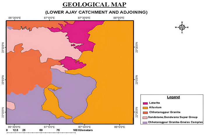
The region is part of the 'Rarh' area.Scientists can study Jurassic plant life because of the extensive collection of Lower Jurassic fossils kept at Amkhoi Fossil Park in Birbhum, India. Gymnosperms and other sedimentary rock formations in the park shed light on the Jurassic period's botanical history as well as the paleogeographical dynamics of the Gondwana continent. The Rajmahal trap basalt, alternating sand and silt, clay layers, hard clays, and granite gneiss enclaves are among the geological features found in the Birbhum district (Figure 1). Amkhoi Wood Fossil Park in Birbhum district has been designated a Biodiversity Heritage Site due to its well-preserved angiosperm wood fossils dating back 20 million years. These fossils, which range from microscopic microbes to large dinosaurs, were found in the Illambazar woodlands near Amkhoi village. Fossils are remnants of once-living organisms preserved for over 10,000 years.
OBJECTIVES
- 1. To assess this geosite's potential for geotourism.
- 2. The study aims to evaluate Amkhoi Fossil Park's scientific, aesthetic, cultural, educational, and recreational value based on the opinions of visitors.
- 3. To evaluate, using a planning evaluation, the ecological, socioeconomic, and sociocultural sustainability elements of geotourism development.
- 4. To improve infrastructure in sustainable facilities and pathways.
- 5. To implement preservation and research initiative
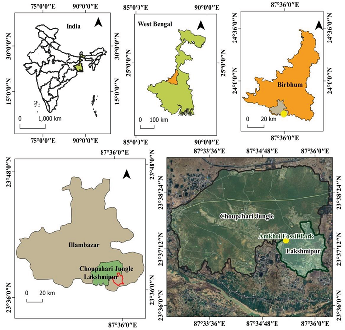
Figure 1
Study Area
Source: The authors (2024).
TERRAIN CHARACTERISTICS
As high land on hard, nonporous rocks with laterites, alluvium, and Gondwana sediments, Birbhum is a component of the Rarh region. With valleys divided by valleys and ridges capped by laterites, the district trends from north-west to south-east. South of Labhpur and Bolpur, there are hills and flat areas in the Rampurhat subdivision. The terrain of the rolling uplands is renowned for its beauty and diversity.The district's geography is undulating; rocks from the Chotanagpur Plateau extend into the western portion, while unconsolidated sediment deposits can be found in the eastern, south-eastern, north-eastern, and southern sections. The mix of lowlands, uplands, and mild slopes in the Illambazar block of Birbhum district, West Bengal, has an impact on drainage, land use, and climate. The productivity of agriculture is increased by its gentle slopes and fertile alluvial plains. The topography is shaped by the Ajay River and its tributaries, but problems like soil erosion and waterlogging still exist. The average slope in this area is 1°, while the maximum recorded slope is 5°. This block's central regions are relatively slopeier than its northern and southern regions (Chatterjee; Dutta, 2022).
Drainage
The district of Birbhum, West Bengal, is home to 130 rivers and numerous drainage ditches. The Ajay River is the main source, but over-extraction could lower water quality. The district is divided into Burdwan and Birbhum, with Mayurakshi and Ajay rivers being notable. Addressing issues like population increase, soil erosion, waterlogging, and scarcity requires integrated water resource management practices. Based on drainage density, the research area is divided into four subclasses, which together account for 144.38, 1331.14, 1995.77, and 1149.42 km2, or 28.81, 43.19, and 24.90% of the total area (Thapa; Gupta, 2017).
Soil
There are several types of soil in different locations, including red soil in the west, laterite soil in the west, and alluvial soil in other parts. The region, which is close to the Santal Pargana district, features undulating topography and laterite, high-medium texture topsoil with granite vein encrustation. Most soils are red laterite and old alluvial, with modest levels of phosphate, potassium, and inorganic matter. The pH of the soil is between 4 and 6.5, and it has a low capacity to hold water. A block in West Bengal, India called Illambazar is well known for having a varied soil composition, which is essential for the area's economy and agricultural output. The area features lateritic and alluvial soils that are good for a range of crops. Terracing and contour plowing are two techniques that help preserve the structure and retention of nutrients in the soil. The Dubrajpur block has a better capacity in the south and consists of five key soil textural groups: extremely fine loam, fine loam, shallow loam, and loamy skeleton (Chatterjee; Dutta, 2022).
Climate
The district in West Bengal, India's Illambazar block, experiences varying temperatures, with the western part being hot and the eastern part being temperate. The monsoon season, accounting for 78% of yearly rainfall, impacts agriculture, with wooded areas acting as a barrier. It is imperative to adopt sustainable environmental practices. Over a total area of 240 km2, the research region sees five classifications of yearly rainfall: very low, low, medium, high, and very high (Thapa; Gupta, 2017).
Flora
Birbhum District in West Bengal has tropical dry deciduous vegetation, with evergreens. The district is divided into flat alluvial plains and semi-arid highlands. Scrubby thickets and laterite soil are prevalent. The Illambazar block has cultivated plains, scrub vegetation, and natural forests, with plant species like Mahua, Sal trees, and Palash. The little West Bengal district of Birbhum has a high floristic diversity and a large number of unrecognized taxa. Six angiospermic taxa were gathered during a field survey: Erycibe paniculata Roxb., Careya arborea Roxb., Celastrus paniculata Willd., Coffea benghalensis Heyne ex Roem. & Schult., Crotalaria verrucosa L., and EulophiaexplanataLindl (Pradhan; Rahaman, 2014).
GEOLOGICAL CHARACTERISTICS
With three morphotectonic divisions and a variety of rock types, West Bengal spans 88752 square kilometers. It has Proterozoic, Tertiary, and Quaternary deposits, including flood plains, older flood plains, and alluviums. It is a component of Eastern India's Precambrian Shield. Geological features found in the Eastern Region include Quaternary Indo-Gangetic Alluvium, Late Cretaceous-Early Palaeocene Rajmahal traps, Proterozoic and Archaean-Proterozoic Rocks, Gondwana Supergroup, and sub-Himalayan foothills. Mineral occurrences can be found in these rocks in West Bengal, Bihar, Jharkhand, and Orissa (Thapa; Gupta, 2017). The Indian Rajmahal volcanics are rich in Middle Jurassic to Lower Cretaceous intertrappean sediments and basalt, with various rocks and fossils. The Amkhoi Fossil Park in Birbhum houses an extensive collection of Lower Jurassic fossils, while Illambazar's red laterite soil is rich in iron and aluminum (Figure 2).
METHODOLOGY
Figure 3 and Figure 4 show the detailed methodology of this paper. It mainly includes the SWOT matrix and AHP.
Swot Matrix
The Strengths, Weaknesses, Opportunities and Threats approach (SWOT approach) is an essential tool for developing tourism and leisure strategies because it integrates pertinent data and offers a thorough assessment of the present state of affairs (Szeliga-Duchnowska; Goranczewski, 2017). Based on both internal and external elements, this analytical process evaluates the opportunities, threats, weaknesses, and strengths of an organization (Figure 3). It also identifies current and future potential and provides recommendations (Nezha et al., 2021). One tool managers use to compare information is the SWOT analysis. By employing it, they can provide four different types of strategies: WO, ST, WT, and SO strategies, among others (Ghanbari et al., 2012). Decision-makers can maximize system strengths and minimize external dangers by using SWOT analysis to identify system strengths, and weaknesses (Mondal, 2017). One of the most popular techniques in strategic management is the SWOT analysis (Goranczewski; Puciato, 2011; Bharat Abhiyan et al., 2021). SWOT analysis is a popular tool in literature that compares a destination's advantages and disadvantages with environmental opportunities and dangers in order to assess the state of affairs today and recommend plans for the future (Pirnaret al., 2019). Organizations can adjust their internal operations to external realities by using a strategic tool called a SWOT analysis to evaluate their strengths, weaknesses, opportunities, and threats (Tambunan, 2020). The SWOT strategic planning model is a decision-making tool used in scientific presentations to determine long-term or short-term strategies and to make critical assessments regarding a variety of obstacles and difficulties (Mustika; Khrisna Aditya, 2018; Das; Roy, 2019; Datta, 2020; Mandal, 2021).
Analytic Hierarchy Process (AHP)
Analytic Hierarchy Process (AHP) is an MCDA tool that compares criteria and options pairwise to facilitate complex decision-making; on the other hand, the SWOT method is a methodical approach to identifying internal strengths and weaknesses (Sahani, 2021). One popular method in multiple criteria decision analysis (MCDA) for environmental and natural resource management is the Analytical Hierarchy Process (AHP) (Sahani, 2019). The study offers the findings of an MCDA model and integrated SWOT analysis for the development of the StaraPlanina resort in Eastern Serbia, producing six options (Nikolić et al., 2015). An MCDM methodology called Analytic Hierarchy Process (AHP) enhances validity and reliability in a variety of decision-making scenarios by taking into account the subjectivities and biases of individual replies (Miljkovićet al., 2018). The Integrated AHP-SWOT (A'WOT) is a strategic technique used to evaluate both internal and external elements impacting the attainment of goals. It combines the analysis of AHP and SWOT (Cvetković; Šljivović, 2021). SWOT analysis is a strategic planning method used in various industries, including tourism. It uses the Analytical Hierarchical Process (AHP) model to assess a region's tourism potential. The AHP method, a multicriteria decision-making approach, combines comparison and evaluation. It uses Saaty's methodology to identify opportunities, threats, weaknesses, and strengths, with the pairwise comparison matrix facilitating comparative relevance values (Tuan; Canh, 2022; Melese; Belay, 2022; Das; Roy, 2019; Mandal, 2021; Stofkova et al., 2022; Saaty, 1987; Melese; Belay, 2022; Ifediegwu, 2022).
Household heads served as the main source of information for a household survey that was used to collect data from respondents in the nearby settlements of the national park (Gidebo, 2019). Likert scales allow respondents to indicate whether they agree or disagree with a collection of statements about an attitude object that have an equal number of positive and negative statements (Olaniy, 2019). Likert-scale surveys are used to measure affective characteristics such as motivation and self-efficacy; however, their efficacy is dependent on piloting the survey, which entails obtaining both quantitative and qualitative input from both familiar and multilingual respondents (Beglar; Nemoto, 2014). Social science rating scales frequently employ a Likert-type scale, in which respondents assign points to assertions and total the points from all of the statements to get their score (James; Lee, 2011). The issue surrounding the Likert scale in social sciences research is examined through a methodical assessment of research articles by specialists, statisticians, and education researchers (Mumu et al., 2022).

Figure 3
SWOT Analysis
Source: The authors (2024)

Figure 4
Flow Chart (Methodology)
Source: The authors (2024).
Fossil
The Anacardiaceae family has the most common woody plants (8 species), followed by the Clusiaceae and Dipterocarpaceae families (6 species), according to the study, which found 104 species from 38 families (Danilov et al., 2020). Asia, South America, and Africa are home to the three transcontinental subfamilies of the Dipterocarpaceae family, whose leaves from Nepal suggest a warm, humid climate (Srivastava et al., 2017). Fossils of Calophyllum L. from Siwalik sediments in the slopes of Darjeeling and the Arunachal sub-Himalaya imply a warm, humid tropical climate during Siwalik sedimentation, with frequent visits to woods during the Neogene era (Khan et al., 2017). The family Dipterocarpaceae, which includes three subfamily types - Dipterocarpoideae in Asia, Pakaraimoideae in South America, and Monotoideae in Africa and South America - dominates huge trees in lowland tropical forests in Asia, Africa, and South America (Srivastava et al., 2014; Jha et al., 2011).
Birbhum district in West Bengal, India, is known for its diverse geological formations, influenced by ancient and recent events. Its topography includes laterite formations, alluvial plains, and ancient rock structures. The district's geological history includes the Pre-Cambrian Era, Gondwana Formations, laterite formations, alluvial deposits, and intrusive granite formations. Understanding these formations is crucial for managing natural resources and planning sustainable development.
FOSSIL ECOSYSTEM
Amkhoi Fossil Park
Amkhoi Fossil Park in West Bengal, India, is known for its wood fossils, providing insight into the region's ecological history. The process of wood fossilization, known as petrification, involves several steps and geological events, with Amkhoi's conditions playing a crucial role (Figure 5).
- 1. Death of the Forest: Wood fossils were created by the death of trees in prehistoric Amkhoi, which were rapidly covered by sediments, mud, or volcanic ash due to the dense forest environment.
- 2. Rapid Burial: Rapid burial in Amkhoi trees, likely due to sediment deposits, slowed decay and set the stage for mineralization, demonstrating the importance of oxygen-free environments in wood fossil formation.
- 3. Mineralization: Over millennia, silica-rich groundwater percolated through sediments, preserving plant material due to its hardness and chemical inertness. As water moved through buried wood, minerals replaced organic material, preserving the wood's intricate structure.
- 4. Silicification and Lithification: Amkhoi fossils often undergo silicification, a process where minerals harden sediment, preserving wood structures as stone and retaining detailed cellular structures, visible under a microscope.
- 5. Erosion and Exposure: Fossils' formation to discovery involves geological processes like erosion, which exposes petrified wood at Amkhoi Fossil Park, revealing the millions-year-old process of nature's forces.
Fossil formation at Amkhoi reveals geological and environmental conditions ideal for turning wood into stone, emphasizing ecological events like tree fall and mineral infiltration. These fossils offer valuable insights into ancient landscapes and climatic conditions.

Figure 5
Field photograph
Source: The authors (2024).
Petrified Wood Formation
Petrified wood, a fossilized material in which organic components have been replaced with minerals while maintaining the original structure, is the main attraction of Amkhoi Fossil Park in West Bengal, India. Petrified wood is the result of a complex interplay between geological, environmental, and biological elements. The region was densely populated, prosperous, and had a subtropical climate with abundant rainfall and lush flora in the late Tertiary period. Permineralization, the process by which fallen trees enter an anaerobic environment and stop decaying and decomposing, is how petrification happens. The organic cellular structure of the buried wood was gradually replaced as silica, calcium carbonate, and other minerals were infused with it over time by mineral-rich water. The surrounding silt may eventually erode away, revealing the fossilized wood. Today, the petrified wood at Amkhoi Fossil Park provides important hints about the climate, plant kinds, and circumstances of the area's past habitats. The rare fossil site known as Amkhoi Fossil Park in West Bengal, India, provides insight into the prehistoric flora of the Permian period, which began about 290 million years ago. The most famous fossils come from the woody, seed-bearing Glossopteris genus, which once dominated the landscapes of the extinct supercontinent Gondwana. These fossils provide evidence for the continental drift idea and shed light on the Earth's climatic, biological, and geographic patterns throughout the Permian era. Remains of other plant species, including seed ferns and ferns, can also be found at the location.
Angiosperm
Amkhoi Fossil Park in West Bengal, India, houses angiosperm wood fossils dating back to the Miocene epoch, revealing the region's evolutionary history and ecological dynamics. The well-preserved specimens, mainly flowering plants, help reconstruct climatic conditions, floral biodiversity, and ecological interactions. Studying these fossils can predict future climate scenarios.
Dipterocarpaceae
Amkhoi Fossil Park in West Bengal, India, is a paleontological site that reveals the presence of Dipterocarpaceae, a family of hardwood tropical trees, in warm, humid conditions during the Pliocene epoch. This discovery has implications for paleoclimatology, biogeography, and conservation of genetic diversity, highlighting the ongoing impacts of environmental changes.
Anacardiaceae
Amkhoi Fossil Park in West Bengal, India, houses a rich fossil record of the Anacardiaceae family, a group of economically significant species. The site, dating back 10-20 million years, provides insights into prehistoric ecosystems and plant diversity, revealing a warm, likely dry climate similar to modern Anacardiaceae species.
Combretaceae
Amkhoi Fossil Park in India houses a vast collection of plant fossils from the Late Tertiary period, revealing a humid, warm climate. These fossils, often found as leaf impressions, are crucial for reconstructing past ecologies, understanding climatic conditions, and are also valuable for education and conservation.
Leguminosae
Amkhoi Fossil Park in West Bengal, India, houses a significant collection of Miocene-era plant fossils, particularly those from the Leguminosae family. These fossils, including legumes, provide insights into ancient soil conditions, vegetation patterns, and climatic shifts, revealing diverse plant communities and their evolution. The park's sedimentary layers offer unique educational resources.
MAJOR FINDINGS
Pairwise Comparison of the SWOT Group's Factors
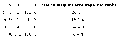
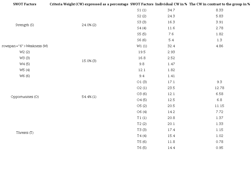
The author used the Saaty scale to compare SWOT factors, determining their relative importance using Eigenvalues. The assigned values were converted into decimal numbers, creating a normalized pairwise matrix with relative weights for Strengths, Weaknesses, Opportunities, and Threats. The table indicates that opportunities have the largest weight among the categories, at 54.4 %, and are followed by threats, weaknesses, and strengths. Even though it has the highest weight among the criteria, the study area's tourism development in terms of geotourism is still behind. Threats (6.6%), Weaknesses (15.0%) and, Strengths (24%) are shown to have the lowest criteria weights; hence, the research area's tourist development in terms of geotourism is facing the fewest risk factors (Table 1).
Source: The authors (2024).
The Amkhoi Wood Fossil Park's distinctive geological features and historical significance make it a site with great geotourism potential. S1's main strength is its distinctive geological features, which include fossils that date back millions of years, making it an intriguing location for both public and scholarly research. 34.7% of the geotourism value of the park is derived from this feature. With a 24.3% contribution, S2 emphasizes its singularity as the only geological fossil park in West Bengal and gives it a special value. S3, which stands for accessibility and connectivity, adds to the park's potential and accounts for 16.3% of its worth. Due to its strong infrastructure, the park is easily accessible by both highways and railroads, making it a popular destination for both tourists and scholars. Contributing 11.6% of the park's total potential, S4 highlights the variety of research options accessible for botanists, geologists, and geographers. In addition, the park serves as a popular tourist destination in the area (S5), accounting for 7.6% of its total value, and it displays a diverse range of wildlife (S6), accounting for 5.4%. When taken as a whole, these advantages highlight the park's enormous geotourism potential and draw both leisure and scholarly visitors (Table 2).

Source: The authors (2024).
Numerous flaws at the Amkhoi Wood Fossil Park could limit the area's potential for geotourism. The fact that 32.4% of the local population is impoverished is a serious worry since it may restrict their ability to support or profit from the growth of the tourism industry. By impeding tourist access and comfort, inadequate infrastructure, such as inadequate roads, lodging, and visitor amenities affects 19.5% of the park's potential.16.8% of all tourism-related activities are unregulated, which puts the park's delicate ecosystem at risk of deterioration. Additionally, there are possible maintenance problems in the park (9.8%), which could have an impact on both conservation efforts and visitor experiences. The park's visibility and appeal are further limited by ineffective marketing (12.1%) and a dearth of online presence and effective advertising (9.4%) (Table 3).

Source: The authors (2024).
There are numerous chances for the Amkhoi Wood Fossil Park to increase its potential for geotourism. Research and educational tours (17.1%) are the best uses for the park, as they can draw in academic institutions and educational groups, increasing the park's visibility and visitor numbers. Additionally, government officials are paying more attention to tourism planning (23.5%), which may result in funding and policies that encourage development. Initiatives for infrastructure development (12.1%) offer an opportunity to strengthen accessibility and visitor amenities while correcting existing shortcomings. Engaging the community (12.5%) provides an opportunity to include locals in tourism-related activities, which can lead to a feeling of economic advantage and ownership. Creating alliances with governmental organizations, non-profits, and educational establishments (20.5%) may offer more resources and knowledge. Finally, increasing the variety of activities offered in the park (14.2%) can draw in a larger audience and improve visitors' experiences. The park may greatly increase both its sustainability and potential for geotourism by taking use of these options (Table 4).
Source: The authors (2024).
The Amkhoi Wood Fossil Park is vulnerable to a number of serious risks that could limit its potential for geotourism. The lack of knowledge and advertising (20.8%) is a major issue as it reduces the park's exposure and draws fewer visitors. Furthermore, 20.1% of the park is susceptible to earthquakes and floods, which could harm its geological and ecological features. Potential visitors are diverted by competition from other regional tourism locations (17.4%), which presents a difficulty. Inadequate conservation efforts are another problem facing the park (15.4%), which may cause its distinctive traits to deteriorate. The integrity of the park is also threatened by encroachment and land use changes (11.8%), which disturb the natural ecosystem. Environmental degradation damages the park's environment, making it more vulnerable. Examples of this degradation include deforestation, pollution, and improper disposal of garbage (14.4%). Preserving the park's geotourism value and guaranteeing its long-term sustainability requires addressing these issues (Table 5).

Source: The authors (2024).
Pairwise Comparison Between the SWOT Factors of Four SWOT Groups
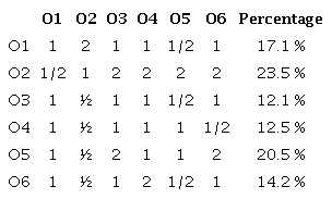
SWOT factors of each SWOT group having the highes local priorities (on the basis of field observation and face to face interviews) have been chosen to represent each group. From table it is observed that O2 i.e. growing attention about tourism planning among government authority has the highest criteria weight (23.5%) in Opportunities. Weakness is responsible for the poor growth of tourism in the study area. Poor awareness (Most of the local people belongs to below the poverty line) (W1) and Inadequate infrastructure such as roads, accomodation and visitor facilities (W2) occupies 32.4 % and 19.5 % are the main problems of this study area. Unique geological features including fossils dating back millions of years (S1) and only geological fossil park in West Bengal (S2) occupies 34.7 % and 24.3 % are the main Strength of this study area. Because of its distinctive geological features, exclusive status, accessibility, potential for research, importance as a local tourist destination, and abundant biodiversity, Amkhoi Fossil Park in West Bengal presents a special geotourism opportunity. Thanks to its 34.7% fossil collection, the site is a favorite among scientists and visitors alike, offering a unique window into Earth's history. Because of its 24.3% exclusivity, it stands out from other attractions and emphasizes the value of protecting geological heritage. Amkhoi is widely accessible for tourists and scholars due to its 16.3% accessibility and 16.3% connectivity. Its 11.6% research potential makes it a center of study and draws interest from academics (Table 6 and Figure 6).
Developing a Strategy Based on the Outcome
This step involved using the TOWS matrix to devise solutions aimed to enhance the research area's current geotourism scenario. Four distinct combinations make up the TOWS matrix: (1) SO (Maxi-Maxi), (2) WO (Mini-maxi), (3) ST (Maxi-Mini), and (4) WT (Mini-Mini).
Maxi-Maxi Strategies (SO)
Strengths: Strategies for taking advantage of possibilities to attract tourists focus on maximizing advantages. This location contributes to the economic and rural development of the area because of its accessibility and connectivity via roads and trains, as well as its distinctive tor and dome formation, which help to generate high aesthetic value and attract a larger, wider target tourist population.
WO Strategies (Mini-Maxi)
Weakness-possibilities strategies address weaknesses in research, such as poor environmental awareness and improper geoconservation management, to promote economic and rural development.
Maxi-Mini Strengths-Threats techniques (ST Strategies)
Techniques focus on leveraging strengths to overcome obstacles, with the study area's strengths being accessibility and unique tor and dome formation, while weaknesses include inadequate geomorphosite conservation and management.
Weakness-Threats (WT) Strategies (Mini-Mini)
Strategies aim to mitigate weaknesses and threats in the study area, including insufficient geoconservation management, lack of environmental awareness, insufficient geomorphosite conservation, and gradual decline in scenic beauty.
Source: The authors (2024).
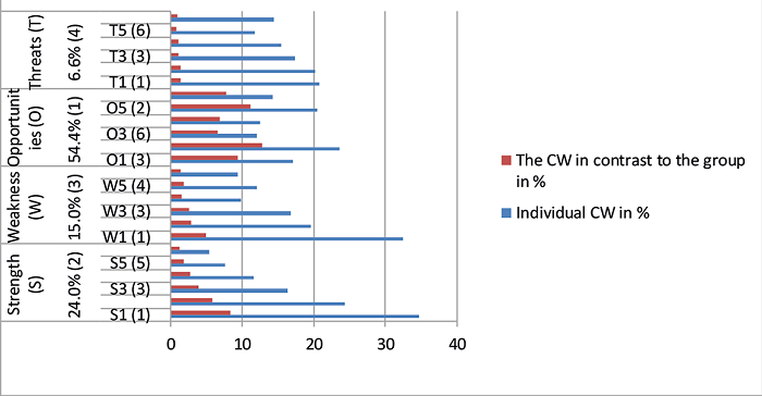
Figure 6
Criteria Weight Distribution
Source: The authors (2024).
Using a Likert scale survey to analyze Amkhoi Fossil Park's geotourism potential offers insightful information about the site's features and visitor experience. An effective tool for quantifying subjective experiences across a range of dimensions, including experience, conservation, awareness, accessibility, facilities, and attributes like geotourism features, security, and impacts, is the Likert scale. This widely used rating method typically goes from 1 (Strongly Disagree) to 5 (Strongly Agree).
Experience
An "excellent" rating might need to be attained by improving experiential elements like interactive exhibits or hands-on fossil digs that could deepen visitor engagement and learning. Overall, the experience category rating of "very good" indicates that visitors generally find their time at Amkhoi Fossil Park enjoyable and enriching. This could be attributed to well-organized tours, knowledgeable guides, and engaging activities that effectively connect visitors with the park's paleontological heritage (Figure 7).

Figure 7
Experience
Source: The authors (2024).
Conservation
Also rated as "very good" are the conservation efforts, which suggest that robust safeguards are in place to preserve the site's fossil and natural riches. This shows that in addition to activities for maintaining the natural ecosystem, the park contributes to the local ecosystem's health. Conservation of rare plants, control of forest fire, the park practices effective conservation of its geological features, the park management employs successful conservation strategies, such as limitations on fossil extraction and habitat disturbance. Potential avenues for future development can include expanding community participation in conservation initiatives or implementing cutting edge ecological preservation techniques (Figure 8).
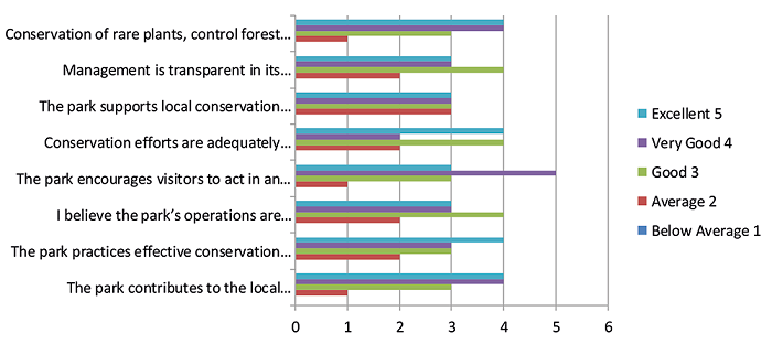
Figure 8
Conservation
Source: The authors (2024).
Awareness
The park has done a great job of informing visitors about the scientific significance of the place and the necessity for conservation, as evidenced by its
"very good" awareness rating. Increasing awareness can entail creating more educational resources and programs for a range of age groups and learning preferences. It might also entail using digital tools or mobile applications for self-guided tours (Figure 9).
Figure 9
Awareness
Source: The authors (2024).
Accessibility
A "very good" score for accessibility also pertains to the park's infrastructure, potentially suggesting that a wide range of visitors, including those with impairments, can navigate the area with some ease. The park might investigate more extensive accessibility upgrades, such as increased rest places, better signage, and maybe more adaptive services like mobility scooters or wheelchairs, in order to make even more progress.
Facilities
A "very good" facility rating indicates that the park probably provides sufficient facilities, like parking, bathrooms, and food services. The park might think about adding eco-friendly technology, cozier relaxation rooms, or more food options that could accommodate a greater range of dietary needs to these establishments in an effort to strive for excellence (Figure 10).
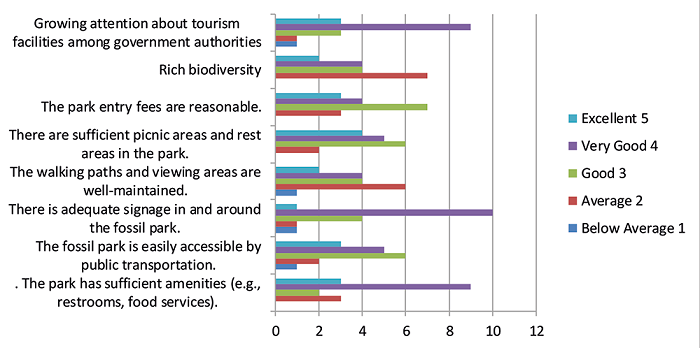
Figure 10
Accessibility and Facilities
Source: The authors (2024).
Geotourism Features
The feedback received from visitors and experienced persons for the geotourism features indicates a high level of satisfaction and appreciation for the department's performance. Particularly noteworthy is the "excellent" grade for geotourism features, indicating that Amkhoi Fossil Park's geological features are extraordinary. The park's attraction and potential for geotourism are largely dependent on these elements, which most likely include easily accessible fossil beds and stunning geological formations. The accolades received for the geological formations in the park are well-preserved and conservation efforts are visible in the park’s operations. Most interesting about the geology of the park, t emphasizes local culture and heritage,benefits the local community economically and socially to providing a high-quality educational experience that meets and exceeds parents' expectations. The park should think about improving guided tour options or producing more thorough educational content about these features in order to take use of this strength (Figure 11).
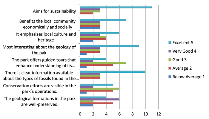
Figure 11
Geotourism Features
Source: The authors (2024).
Security
A good visitor experience depends on guests feeling safe in the park, and security's "excellent" rating reflects this. The park is safe for visitors of all ages, staff are trained to handle emergencies. The park conducts regular safety audits to ensure visitor safety. There are security personnel present in the park. Easily can emergency vehicles access the site. Safe for wildlife in the area that could pose a risk to tourists. This will continue to be a selling point for the park if security measures are maintained, if not improved (Figure 12).
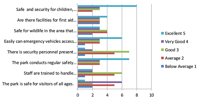
Figure 12
Security and Safety
Source: The authors (2024).
Impacts
Last but not least, the park's "excellent" impact rating attests to its beneficial effects on both locals and tourists. This could entail improved environmental knowledge, financial gains, or cultural enrichment. The park creates jobs for the local community and employs local residents. Local businesses benefit from the visitors to the park enjoy diversification of activities. In order to optimize these beneficial effects, future policies and activities might be guided by ongoing efforts to monitor and research these consequences (Figure 13).
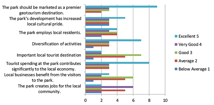
Figure 13
Impacts
Source: The authors (2024).
Overall, the Amkhoi Fossil Park shows a strong geotourism potential with areas of excellence that can be leveraged to enhance areas that are already performing well but could achieve higher visitor satisfaction and engagement.
CONCLUSION
A unique geotourism experience can be had in Amkhii Wood Fossil Park. It is a unique geological site. Notwithstanding obstacles such as inadequate infrastructure and restricted promotion, it presents chances for financial expansion and engagement with the community. Anthropogenic and environmental variables are threats. The park's distinctive geological value can be leveraged, infrastructural deficiencies can be addressed. Tourist amenities may be invested in community-based tourism initiatives can be encouraged. Amkhoi Wood Fossil Park in West Bengal, India, has a special opportunities for the growth of geotourism because of its importance in paleontology. It is necessary to adopt a comprehensive approach that includes community involvement, environmental conservation, and educational outreach. This can encourage geoscience literacy and act as a catalyst for a sustainable economy. Diverse audiences can be drawn in by using sustainable infrastructure development and marketing techniques. Geomarketing will be have a great prosperity in this region.
SUGGESTIONS
Amkhoi Fossil Park in Birbhum District has potential for sustainable geotourism due to its rich geological heritage. Strategies include resource interpretation, infrastructure development, community involvement, environmental conservation, and marketing. Informational signage, guided tours, and interactive exhibits can enhance visitor experiences. Collaborating with local communities and implementing sustainable practices can promote socio-economic benefits. A comprehensive marketing strategy can attract tourists to the park, raising awareness about its unique attractions. Ecotourism strategies should be designed as guidelines. In fact, ecotourism involves preserving natural habitats and cultural heritage sites, involving local communities in planning and management, raising environmental awareness, promoting low-impact tourism activities, and managing capacity. It also adopts renewable energy sources, certification programs, and promotes local products. Biodiversity conservation is supported through ecotourism revenue and conservation projects. Continual research and monitoring are conducted to assess ecological and socio-economic impacts of ecotourism, ensuring long-term sustainability. This approach supports the preservation of natural resources and promotes sustainable practices.
REFERENCES
AMARO, S.; CHAVES, N. B.; HENRIQUES, C.; BARROCO, C. Motivation-Based Segmentation of Visitors to a UNESCO Global Geopark. Geoheritage, v. 15, n. 2, 2023. Doi: 10.1007/s12371-023-00848-3
AVELAR, S.; MANSUR, K. L.; ANJOS, S. C.; VASCONCELOS, G. F. Community Perceptions for Geoconservation of a Coastal Area in Rio de Janeiro, Brazil. Geoheritage , v. 7, n. 3, p. 275-283,2015. Doi: 10.1007/s12371-014-0130-z
BATRA, A. Himalayan ecotourism in Shimla. ABAC Journal, v. 21, n. 3, 2001.
BEGLAR, D.; NEMOTO, T. Developing Likert-scale questionnaires. JALT2013 Conference Proceedings, p. 1-8, 2014.
BELIJ, M.; ĐURĐIĆ, S.; STOJKOVIĆ, S. The evaluation of geoheritage for geotourism development: Case study on the potential Geopark Djerdap. Zbornik Radova. Geografski Fakultet Univerziteta u Beogradu, n. 66-2, p. 121-132, 2018. Doi: 10.5937/zrgfub1802121b
BHARAT ABHIYAN, S.; YAGNIK, S.; YAGNIK, V.; PROFESSOR, A. Swot Analysis of Udaipur Tourism and. Peer Reviewed and Refereed Journal, v. 816, n. 10,p. 121-128, 2021. http://ijmer.in/pdf/e-Certificate of Publication-IJMER.pdf.
BORKAKOTI, S. K.; GOGOI, P.; RIVER, L.; CONSULTING, S.; KONWAR, J.; SAIKIA, R. Majuli: Resources and Challenges. In: BORKAKOTI, Sanjiv Kumar (ed.). Majuli as a Tourism Destination : Reality and Challenges, 2017.
CHAKRABARTY, P.; MANDAL, R. Geotourism development for fossil conservation: A study in amkhoi fossil park of West Bengal in India. Geojournal of Tourism and Geosites, v. 27, n. 4, p. 1418-1428, 2019. Doi: 10.30892/gtg.27425-444
CHATTERJEE, S.; DUTTA, S. Assessment of groundwater potential zone for sustainable water resource management in south-western part of Birbhum District, West Bengal. Applied Water Science, v. 12, n. 3, 2022. Doi: 10.1007/s13201-021-01549-4
CORONATO, A.; SCHWARZ, S. Approaching geodiversity and geoconservation in Argentina. International Journal of Geoheritage and Parks, v. 10, n. 4, p. 597-615, 2022. Doi: 10.1016/j.ijgeop.2022.08.011
CVETKOVIĆ, M.; ŠLJIVOVIĆ, M. Prioritization of strategies for development of ecotourism by means of ahp-swot on the example of Kopaonik, Serbia. Polish Journal of Environmental Studies, v. 30, n. 6, p. 4933-4943,2021. Doi: 10.15244/pjoes/135721
DANILOV, D. A.; THI DUONG, N.; BELYAEVA, N. V. The diversity of tree species in plant communities with the prevalence of the Dipterocarpaceae family tree species in Binh Chau -Phuoc Buu Nature Reserve - Vietnam. IOP Conference Series: Earth and Environmental Science, v. 574, n. 1, 2020. Doi: 10.1088/1755-1315/574/1/012017
DAS, M.; ROY, P. B. Geotourism Potential of Gangani, West Bengal, India: A SWOT-AHP Approach. Journal of Hospitality and Tourism, v. 16, n. 1, p. 1-8. 2019.
DATTA, K. Application of SWOT-TOWS Matrix and Analytical Hierarchy Process (AHP) in the Formulation of Geoconservation and Geotourism Development Strategies for Mama Bhagne Pahar: an Important Geomorphosite in West Bengal, India. Geoheritage , v. 12, n. 2, p. 1-11, 2020. Doi: 10.1007/s12371-020-00467-2
DE LIMA, F. F.; BRILHA, J. B.; SALAMUNI, E. Inventorying Geological Heritage in Large Territories: A Methodological Proposal Applied to Brazil. Geoheritage , v. 2, n. 3, p. 91-99, 2010. Doi: 10.1007/s12371-010-0014-9
DEBNATH, P.; SAHA, A. Potential benefit of eco-tourism of dooars in Alipurduar district of West Bengal. International Journal of Research in Social, v. 9, n. 5, 2019. https://www.indianjournals.com/ijor.aspx?target=ijor:ijrss%5C&volume=9%5C&issue=5%5C&article=021
DINGWALL, P.; WEIGHELL, T.; BADMAN, T. Geological World Heritage: A Global Framework - A Contribution to the Global Theme Study of World Heritage Natural Sites. IUCN, 2005.
DOWLING, R. K. Geotourism’s Global Growth. Geoheritage , v. 3, n. 1, p. 1-13. 2011. Doi: 10.1007/s12371-010-0024-7
DOWLING, R. K. Global Geotourism - An Emerging Form of Sustainable Tourism. Czech Journal of Tourism, v. 2, n. 2, 2014. Doi: 10.2478/cjot-2013-0004
ESHRAGHI, M.; AHMAD, H.; TORIMAN, M. E. Contribution of geomorphological assessment for sustainable geotourism: A case of Iran’s Desert. Advances in Environmental Biology, v. 6, n. 3, p. 1188-1195, 2012.
FARSANI, N. T.; COELHO, C.; COSTA, C. Geotourism and Geoparks as Gateways to Socio-cultural Sustainability in Qeshm Rural Areas, Iran. Asia Pacific Journal of Tourism Research, v. 17, n. 1, p. 30-48. 2012. Doi: 10.1080/10941665.2011.610145
GHANBARI, H.; POUR, M. A. A.; BARSHOD, A. Using SWOT analysis in tourism studies with system approach. Advances in Environmental Biology , v. 6, n. 11, p. 2953-2957, 2012.
GHOSH, A.; MUKHOPADHYAY, S.; CHATTERJEE, S. Assessment of geoheritage and prospects of geotourism: An approach to geoconservation of important geological and geomorphological sites of Puruliya district, West Bengal, India. International Journal of Geoheritagea nd Parks, v. 9, n. 2, p. 264-283, 2021. Doi: 10.1016/j.ijgeop.2021.03.001
GHOSH, S. Development of Geotourism using SWOT Matrix and Analytical Hierarchy Process (AHP) for Mama- Bhagne Pahar Area of Birbhum, West Bengal, India. IJSS - Indian Journal of Spatial Science, v. 15, n. 1, p. 17-23, 2024.
GIDEBO, H. Attitude of Local Communities Towards Sustainable Tourism Development, the Case of Nech Sar National Park, Ethiopia. International Journal of Advanced Research, v. 7, n. 3, p. 650-663, 2019. Doi: 10.21474/ijar01/8684
GORANCZEWSKI, B.; PUCIATO, D. SWOT analysis in the formulation of tourism development strategies for destinations. Turyzm/Tourism, v. 20, n. 2, p. 45-53, 2011. Doi: 10.2478/v10106-010-0008-7
HOSE, T. A. European ‘geotourism’ - geological interpretation and geoconservation promotion for tourists. In BARETTINO, D.; WIMBLEDON, W. A. P; GALLEGO, ERNESTO. Geological Heritage: its conservation and management, 2000.
HOSE, T. A. Editorial: Geotourism and Geoconservation. Geoheritage , v. 4, n. 1-2, p. 1-5, 2012. Doi: 10.1007/s12371-012-0059-z
HOSE, T. A.; VASILJEVIĆ, D. A. Defining the Nature and Purpose of Modern Geotourism with Particular Reference to the United Kingdom and South-East Europe. Geoheritage , v. 4, n. 1-2, p. 25-43, 2012. Doi: 10.1007/s12371-011-0050-0
IFEDIEGWU, S. I. Assessment of groundwater potential zones using GIS and AHP techniques: a case study of the Lafia district, Nasarawa State, Nigeria. Applied Water Science , v. 12, n. 1, p. 1-17, 2022. Doi: 10.1007/s13201-021-01556-5
JAMES, T. C.; LEE, O. Using Likert-type scales in the social sciences. Journal of Adult Education, v. 40, n. 1, p. 19-22, 2011.
JHA, A. K.; CHAKRABORTY, A.; RATHORE, V. S., et al. Geoinformatics Based Geo-Structural and Geomorphological Study in the Lower Catchment of River Ajay, West Bengal, India, p. 1-17, 2011. Available in: https://www.researchgate.net/publication/222710318_Geoinformatics_based_geo-structural_and_geomorphological_study_of_Lower_Ajay_catchment_West_Bengal_India
KHAN, M. A.; SPICER, R. A.; SPICER, T. E. V.; BERA, S. Evidence for diversification of Calophyllum L. (Calophyllaceae) in the Neogene Siwalik forests of eastern Himalaya. Plant Systematics and Evolution, v. 303, n. 3, p. 371-386, 2017. Doi: 10.1007/s00606-016-1376-5
KUBALÍKOVÁ, L. Geomorphosite assessment for geotourism purposes. Czech Journal of Tourism , v. 2, n. 2, p. 80-104, 2014. Doi: 10.2478/cjot-2013-0005
MANDAL, T. Geotourism Potentiality of the Rarh Region of West Bengal: A Geographical Outlook. International Journal of Multidisciplinary, v. 6, n. 12, p. 90-97, 2021. Doi: 10.31305/rrijm.2021.v06.i12.013
MATHUR, S.; SUDHANSHU, P.; SINGH, S. K.; MATHUR, S. C. Paleontological resources for Geotourism in barmer area of western Rajasthan, India: Implication for A national fossil park development. Geojournal of Tourism and Geosites , v. 28, n. 1, p. 203-216, 2020. Doi: 10.30892/GTG.28116-463
MELESE, T.; BELAY, T. Groundwater Potential Zone Mapping Using Analytical Hierarchy Process and GIS in Muga Watershed, Abay Basin, Ethiopia. Global Challenges, v. 6, n. 1,2022. Doi: 10.1002/gch2.202100068
MIGOŃ, P. Granite landscapes, geodiversity and geoheritage-global context. Heritage, v. 4, n. 1, p. 198-219, 2021. Doi: 10.3390/heritage4010012
MILJKOVIĆ, D.; BOŽIĆ, S.; MILJKOVIĆ, L.; MARKOVIĆ, S. B.; LUKIĆ, T.; JOVANOVIĆ, M.; BJELAJAC, D.; VASILJEVĆ, D. A.; VUJIČIĆ, M. D.; RISTANOVIĆ, B. Geosite Assessment Using Three Different Methods; A Comparative Study of the Krupaja and the Žagubica Springs-Hydrological Heritage of Serbia. Open Geosciences, v. 10, n. 1, p. 192-208, 2018. Doi: 10.1515/geo-2018-0015
MIRARI, S.; AOULAD-SIDI-MHEND, A.; BENMLIH, A. Geosites for geotourism, geoheritage, and geoconservation of the khnefiss national park, southern Morocco. Sustainability (Switzerland), v. 12, n. 17, 2020. Doi: 10.3390/su12177109
MONDAL, S. H. SWOT Analysis and Strategies to Develop Sustainable Tourism in Bangladesh. UTMS Journal of Economics, v. 8, n. 2, p. 159-167, 2017.
MUMU, J.; TANUJAYA, B.; CHARITAS, R.; PRAHMANA, I. Likert Scale in Social Sciences Research: Problems and Difficulties. FWU Journal of Social Sciences, v. 16, n. 4, p. 89-101, 2022. Doi: 10.51709/19951272/Winter2022/7
MUSTIKA, A.; KHRISNA ADITYA, M. SWOT Analysis of Rural Tourism Development: Case Study of Kampung Tajur, Purwakarta. Proceedings of the 2nd International Conference on Tourism, Gastronomy, and Tourist Destination (ICTGTD 2018). p. 19-28, 2018. Doi: 10.2991/ictgtd-18.2018.3 (Series: Advances in Economics, Business and Management Research). Available: https://www.atlantis-press.com/proceedings/ictgtd-18/25894558
MUSTOE, G.; ARANYANARK, C.; BOONCHAI, N.; JINTASAKUL, P. A New Look at Cenozoic Fossil Wood from Thailand. Geosciences (Switzerland), v. 12, n. 8, 2022. Doi: 10.3390/geosciences12080291
NEZHA, M.; ROSSI, A.; EL KHALIDI, K.; PAVEL, A.-B.; CHERIF, E. K.; EL OUATY, O.; FEKRI, A. A SWOT Analysis to understand the impact of tourism industry on the Three pillars social Economy and Environment. SHS Web of Conferences, v. 119, n. 04004, 2021. Doi: 10.1051/shsconf/202111904004
NIKOLIĆ, D.; SPASIĆ, J.; ŽIVKOVIĆ, Ž.; DJORDJEVIĆ, P.; MIHAJLOVIĆ, I.; KANGAS, J. SWOT - AHP model for prioritzation of strategies of the resort Stara Planina. Serbian Journal of Management, v. 10, n. 2, p. 141-150, 2015. Doi: 10.5937/sjm10-8928
ÓLAFSDÓTTIR, R.; TVERIJONAITE, E. Geotourism: A systematic literature review. Geosciences (Switzerland), v. 8, n. 7, 2018. Doi: 10.3390/geosciences8070234
OLANIY, A. A. Application of Likert scale’s type and Cronbach’s alpha analysis in an airport perception study. Scholar Journal of Applied Sciences and Research, v. 2, n. 4, p. 1-5, 2019. http://innovationinfo.org/articles/SJASR/SJASR-4-223.pdf
PÁSKOVÁ, M.; WALL, G.; ZEJDA, D.; ZELENKA, J. Tourism carrying capacity reconceptualization: Modelling and management of destinations. Journal of Destination Marketing and Management, v. 21, 2021. Doi: 10.1016/j.jdmm.2021.100638
PIRNARET, İ.; KURTURAL, S.; ERIŞ, E. D. SWOT-TOWS Analysis of Urla Destination’s Alternative Tourism Development. International Journal of Contemporary Tourism Research, p. 235-244, 2019. Doi: 10.30625/ijctr.650380
PRADHAN, B.; RAHAMAN, C. H. New addition to the flora of Birbhum district, West Bengal, India. Journal on New Biological Report, v. 3, n. 3, p. 234-239, 2014.
PRASAD TIWARI, A.; MAGESH, C R.; RIZVI, N. Flowering Plants of Ghughua Fossil Park, Madhya Pradesh, India. New York Science Journal 2017;10(10). Doi: 10.7537/marsnys101017.01.
RAHA, S.; MONDAL, M.; GAYEN, S. K. Ecotourism Potential Zone Mapping by Using Analytic Hierarchy Process (AHP) and Weighted Linear Algorithm: A Study on West Bengal, India. Journal of Geographical Studies, v. 5, n. 2, p. 44-64, 2021. Doi: 10.21523/gcj5.21050201
RAMAIYA, D. V. Geoheritage sites of Madhya Pradesh and Chhattisgarh and their preservation and management. December, 2015. https://www.researchgate.net/publication/303372974_Geoheritage_sites_of_Madhya_Pradesh_and_Chhattisgarh_and_their_preservation_and_management
ROTE, P. J. G. Paleontological parks and museums and prominent fossil sites in Thailand and their importance in the conservation of fossils [Les parcs et musées paléontologiques et les principaux gisements fossilifères de Thaïlande: leur rôle dans la sauvegarde des fossiles]. LIPPS, J.H.; GRANIER, B.R.C. (eds.). PaleoParks - The protection and conservation of fossil sites worldwide Carnets de Géologie / Notebooks on Geology, p. 75-95, 2009. http://paleopolis.rediris.es/cg/BOOKS/CG2009_B03/CG2009_B03_Chapter07.pdf
SAATY, R. W. The analytic hierarchy process-what it is and how it is used. Mathematical Modelling, v. 9, n. 3-5, p. 161-176, 1987. Doi: 10.1016/0270-0255(87)90473-8
SAHANI, N. Assessment of ecotourism potentiality in GHNPCA, Himachal Pradesh, India, using remote sensing, GIS and MCDA techniques. Asia-Pacific Journal of Regional Science, v. 3, n. 2, p. 623-646, 2019. Doi: 10.1007/s41685-019-00116-9
SAHANI, N. Application of analytical hierarchy process and GIS for ecotourism potentiality mapping in Kullu District, Himachal Pradesh, India. Environment, Development and Sustainability, v. 22, n. 7, p. 6187-6211, 2020. Doi: 10.1007/s10668-019-00470-w
SAHANI, N. Application of hybrid SWOT-AHP-FuzzyAHP model for formulation and prioritization of ecotourism strategies in Western Himalaya, India. International Journal of Geoheritage and Parks, v. 9, n. 3, p. 349-362, 2021. Doi: 10.1016/j.ijgeop.2021.08.001
SAHARIAH, D.; SINGHA, K.; BORA, D. K.; KUNDU, S.; DAS, T.; SEN, S.; DAS, K.; MILI, B.; BARUAH, J.; SARMA, K.; SAIKIA, M.; SAIKIA, A. Majuli at the crossroads: A study of cultural geomorphology. Space and Culture, India, v. 1, n. 2, p. 12-20, 2013. Doi: 10.20896/saci.v1i2.26
SEN, S. Ecotourism in West Bengal: Amkhoi Wood Fossil Park. International Journal of Advances in Engineering and Management, v. 2, n. 3, p. 214-217, 2020. Doi: 10.35629/5252-0203214217
SINGH, A. Plight of Salkhan Fossil Park in Uttar Pradesh. January, 2016. https://www.researchgate.net/publication/292149747_Plight_of_Salkhan_Fossil_Park_in_Uttar_Pradesh
SRIVASTAVA, G.; ADHIKARI, P.; MEHROTRA, R. C.; PAUDEL, L.; UHL, D.; PAUDAYAL, K. N. Dipterocarpus Gaertn. (Dipterocarpaceae) leaf from the Middle Siwalik of eastern Nepal and its phytogeographic and climatic significance. Journal of Nepal Geological Society, v. 53, p. 39-45, 2017. Doi: 10.3126/jngs.v53i0.23799
SRIVASTAVA, R.; CHANDEL, R. S.; SINGH, S. Fossil wood of Dipterocarpus from Nagri Formation (Middle Siwalik) of India: palaeoclimatic and phytogeographical significance. Journal of Palaeosciences, v. 63, n. 1-2, p. 41-49, 2014. Doi: 10.54991/jop.2014.320
STOFKOVA, J.; KREJNUS, M.; STOFKOVA, K. R.; MALEGA, P.; BINASOVA, V. Use of the Analytic Hierarchy Process and Selected Methods in the Managerial Decision-Making Process in the Context of Sustainable Development. Sustainability (Switzerland), v. 14, n. 18, 2022. Doi: 10.3390/su141811546
SUMANAPALA, D.; WOLF, I. D. Man-Made Impacts on Emerging Geoparks in the Asian Region. Geoheritage , v. 12, n. 3, 2020. Doi: 10.1007/s12371-020-00493-0
SUZUKI, D. A.; TAKAGI, H. Evaluation of Geosite for Sustainable Planning and Management in Geotourism. Geoheritage , v. 10, n. 1, p. 123-135, 2020. Doi: 10.1007/s12371-017-0225-4
SZELIGA-DUCHNOWSKA, A.; GORANCZEWSKI, B. Use of Tows Analysis in Tourism and Recreation Strategy Planning by a Commune Governing the Hosting Area. Ekonomiczne Problemy Turystyki, v. 40, n. 40, p. 103-114, 2017. Doi: 10.18276/ept.2017.4.40-09
TAMBUNAN, T. S. SWOT Analysis for Tourism Development Strategy of Samosir Regency. The International Journal of Applied Business - TIJAB, v. 4, n. 2, p. 90, 2020. Doi: 10.20473/tijab.v4.i2.2020.90-105
THAPA, R.; GUPTA, S. Assessment of groundwater potential zones using multi-influencing factor (MIF) and GIS: a case study from Birbhum district, West Bengal. Applied Water Science , v. 7, n. 7, p. 4117-4131, 2017. Doi: 10.1007/s13201-017-0571-z
THOMAS, B. Ecotourism: A Sustainable Development Connect to Nature and A Strategy for Balancing Economic Growth, Socio-Cultural Development and Conservation. APJAET - Journal Ay Asia Pacific Journal of Advanced Education and Technology, v. 1, n. 1, p. 64-72, 2022. Doi: 10.54476/apjaetv1i1mar20229903
TUAN, N. H.; CANH, T. T. Integral Swot-Ahp-Tows Model for Strategic Agricultural Development in the Context of Drought: a Case Study in Ninh Thuan, Vietnam International Journal of the Analytic Hierarchy Process, v. 14, n. 1, p. 1-30, 2022. Doi: 10.13033/IJAHP.V14I1.890
WOODIER, N. International perspectives. In: ASHMORE, Z.; SHUKER, R. (ed.). Forensic Practice in the Community, London: Routledge, p. 61-81, 2014. Doi: 10.4324/9780203485804
ZGŁOBICKI, W.; BARAN-ZGŁOBICKA, B. Geomorphological Heritage as a Tourist Attraction. A Case Study in Lubelskie Province, SE Poland. Geoheritage , v. 5, n. 2, p. 137-149, 2013. Doi: 10.1007/s12371-013-0076-6