Papers
Multicriteria Model for Prospective Locations for Sediment Dump Sites Coastal Dunes Management: Case Study from Barroquinha City, Northeast Brazil
 Matheus Domingos Andrade de Sá matheusandradesa@gmail.com
Tiago Borges Ribeiro Gandra gandratiagobr@gmail.com
Miguel da Guia Albuquerque migueldaguia@gmail.com
Davis Pereira de Paula davis.paula@uece.br
Marcelo de Oliveira Soares marcelosoares@ufc.br
Eduardo Lacerda Barros eduardolacerdab@gmail.com
Renan Gonçalves Pinheiro Guerra renan.lgco@gmail.com
Melvin Moura Leisner melvin.leisner@aluno.uece.br
Jade Moreira jade.moreira@acad.pucrs.br
Matheus Domingos Andrade de Sá matheusandradesa@gmail.com
Tiago Borges Ribeiro Gandra gandratiagobr@gmail.com
Miguel da Guia Albuquerque migueldaguia@gmail.com
Davis Pereira de Paula davis.paula@uece.br
Marcelo de Oliveira Soares marcelosoares@ufc.br
Eduardo Lacerda Barros eduardolacerdab@gmail.com
Renan Gonçalves Pinheiro Guerra renan.lgco@gmail.com
Melvin Moura Leisner melvin.leisner@aluno.uece.br
Jade Moreira jade.moreira@acad.pucrs.br
Multicriteria Model for Prospective Locations for Sediment Dump Sites Coastal Dunes Management: Case Study from Barroquinha City, Northeast Brazil
Sociedade & Natureza, vol. 36, no. 1, e71113, 2024
Editora da Universidade Federal de Uberlândia - EDUFU
Received: 12 October 2023
Accepted: 14 May 2024
Published: 04 July 2024
Funding
Funding source: FUNCAP
Contract number: FCT AAC No. 02/SAICT/2017
Funding
Funding source: FUNCAP
Contract number: PS1-00186-00333.01.00/21
Funding
Funding source: FUNCAP
Contract number: FCT AAC No. 02/SAICT/2017
Funding
Funding source: CNPq
Contract number: Project N◦. 420516/2022-0
Funding
Funding source: CNPq
Contract number: CNPq Productivity PQ 309102/2022-7
Funding statement: We acknowledge the FUNCAP to projects (FCT AAC No. 02/SAICT/2017, PS1-00186-00333.01.00/21, UNI-0210-00736.01.00/23). Too would like to thank the Conselho Nacional de Desenvolvimento Científico e Tecnológico - CNPq (National Council for Scientific and Technological Development - CNPq)Project N◦. 420516/2022-0, CNPq Productivity PQ 309102/2022-7). Too would like to thank the Instituto Federal do Rio Grande do Sul - IFRS (Federal Institute of Rio Grande do Sul - IFRS) and the Laboratório de Geologia e Geomorfologia Costeira e Oceânica - LGCO/Universidade Estadual do Ceará - UECE (Laboratory of Coastal and Oceanic Geology and Geomorphology - LGCO/State University of Ceará - UECE) for logistical assistance and access to laboratories
Abstract: Coastal zones are attractive for the development of economic interests (real estate and tourism) and are intensely occupied in a disorderly manner. Development in areas with available sediments can lead to conflicts between the natural movement of dunes and cities and communities and may result in burial processes. In addition, natural structures, such as dunes, play key roles in protecting against coastal erosion by balancing the beach-dune system with the sediment input, thus slowing the erosion process. This study aims to determine suitable areas for creating dune field dump sites in Barroquinha, Ceará, northeastern Brazil. The results showed that along the study area, the places with the greatest viability for creating dump sites were those furthest from the urban and permanent protection areas. In the stretch connecting Barroquinha City to the Bitupitá community on the CE-187 highway, 45 deposition points were monitored across five sectors under different environmental conditions. Sectors 2, 3, and 4 showed good responses to sediment fixation, in agreement with what was presented in the locational feasibility model. These results add to the discussion on urban infrastructure burying processes, making important contributions to urban planning and management in coastal areas. The results of this study will form an integral part of the Regional Contingency Plan for Incidents and/or situations of risk of environmental impacts in the coastal and/or oceanic zones of Ceará, which was conceived by the Chief Environment Scientist Program of Ceará State and contributes to the Action Plan against burying infrastructure by dune fields.
Keywords: Analytic Hierarchy Process (AHP), Dune, Sediment, Discard.
INTRODUCTION
Urbanization in coastal areas impacts the hydrogeological dynamics of mangrove ecosystems (Cantelon, 2022) and is at risk of being buried by sediments from dune fields (Rocha, M. N. et al., 2020). In several regions of the Brazilian coast, the large amount of available sediment combined with the rapid and disorderly growth of cities has resulted in the burying of urban infrastructure.
According to Jennings and Lockie (2002), the nature of coastal landscapes is a major attraction, especially for tourism, real estate expansion, recreation, agriculture, and fishing. Some cities on the coast of Ceará, northeastern Brazil, expanded over dune fields and features such as cliffs and estuaries, causing extensive damage to these environments (Rocha, C. D. S. et al., 2020). Structures such as dunes play a key role in protecting against coastal erosion by balancing the beach dune system with sediment input. Dunes also play an important role in preventing inner water salinization in coastal zones as they raise the water table and prevent saline groundwater intrusion (Neto et al., 2018).
The use of natural resources in coastal areas has led to environmental impacts. The development of human activities in coastal areas has led to some localities experiencing conflicts and greater vulnerability, whether in space, economy, or culture (Moraes 2007; Junior, 2022). In addition, some areas with dunes still experience erosive episodes. Coastal dynamics involve several elements, including wind, which helps sediment transport and intensifies the erosion process, in many cases caused by anthropogenic intervention (Sherman; Bauer, 1993; Ruz; Meur-Ferec, 2004).
On the coastal surface, water and wind are the main factors responsible for erosion and sediment transport processes. However, there is a significant difference between the processes of sedimentary dynamics related to velocity and transport volume because hydrodynamic processes act more intensely than aeolian processes (Pye; Tsoar, 2009). Even with a lower remobilization capacity, aeolian transport manages to accumulate sediments and promote sediment transport and morphological changes over distances that can reach thousands of kilometers. Thus, winds give rise to particular features among the most recurrent dunes (McKee, 2004; Baas, 2007).
Geoprocessing has become an important spatial analysis tool and decision making can cover many themes. According to Santos (2004), response systematization is essential for decision-making as it involves complex information about agents and actors from different perspectives. Multi-criteria analysis is one of the most commonly used methodologies to solve this type of problem, comparing and evaluating several criteria from weight attribution (Ozkan et al., 2019).
The problems facing society are mostly geographical; therefore, the combination of a geographic information system (GIS) with multi-criteria decision analysis (MCDA) is important for studies that research environmental areas. This combination transforms and combines spatial data that comprise criteria and values to solve problems, such as defining areas for a particular human activity. It considers geographical data, spatial dimensions, the definition of evaluation criteria, and decision alternatives for evaluation (Ryan, 2019).
Among the methods developed for decision-making, the most widely used is the analytic hierarchy process (Oropeza-Orozco et al., 2011; Martínez et al., 2013), developed by Saaty (1990). In AHP, decision problems are divided into hierarchical levels, facilitating comprehension and evaluation. This method allows subjective evaluations made by experts and collaborators based on experience and academic knowledge to be transformed into numerical values to construct a pairwise comparison matrix.
This study aims to utilize the AHP approach based on parameters and indicators related to the dune migration process to identify suitable locations for the creation of excess sediment disposal areas in dune fields. It proposes the use of multicriteria analysis of prospective locations for relocating dune sediments, aiming to determine environmentally less vulnerable areas that will have a reduced impact on residents. This is of great importance for managing these environments, highlighting the relevance of applying GIS (Geographic Information Systems) techniques in environmental studies and as an essential tool for decision-makers.
STUDY AREA
The study was conducted in Barroquinha City. It is located 420 km from Fortaleza, in the state of Ceará. It is in the mesoregion of northwest Ceará and is in sector IV in the extreme west of the Ceará littoral zone. This region has a preserved dune field of approximately 27 ha. The dunes in Barroquinha are oriented predominantly from east to west, a characteristic pattern of the Ceará state, parallel to half-moon-shaped trade winds (Claudino-Sales; Carvalho, 2014). The locality has vast sediment availability and high-intensity winds with an average speed of 15 m.s-1, constituting ground-risk areas.
The region faces the problem of the burying of the CE-187 highway, connecting the municipal seat to the fishing community in Bitupitá, by sand dunes. The highway is the only access route for the community and is vital for economic activities, tourism, and basic services.
The study area, a comprised 200 m stretch of the CE-187 highway between the municipal seat and the fishing community of Bitupitá, extending 200 m on both sides of the highway. This value was defined by considering several elements that constitute a regional ecosystem. (Figure 1).
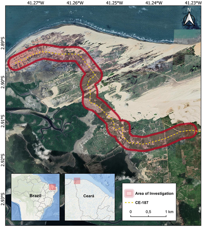
CE-187 is located in a sensitive area from an ecosystem perspective and is compressed by an extensive dune field and permanent protection areas such as apicuns and mangroves. Thus, correct management is fundamental for the community, as well as the local economy. Management is a palliative action necessary for the dynamics of a region and the development of economic activities. (Figure 2).

Figure 2
Burial area on CE-187.
Source: The authors (2022).
MATERIALS AND METHODS
The method was divided into three stages which are described in the following sections: (3.1) fieldwork, (3.2) definition of criteria and weights and implementation of the AHP method, and (3.3) adaptation of multicriteria analysis of locational feasibility method.
Fieldwork
During the period between January 24 and 27, 2022, fieldwork was conducted along the CE-187 highway (Figure 1). In order to obtain a comprehensive overview of the study area, an unsupervised aerial survey was carried out using a DJI Phantom 4 Pro V2 Remotely Piloted Aircraft (RPA). The aircraft consists of a multi-rotor quadcopter equipped with a five-way obstacle sensor, Global Navigation Satellite System (GNSS) navigation receiver, compass, barometer and Inertial Measurement Unit (IMU) modules. This aerial survey made it possible to efficiently identify the areas of sediment deposition from the dune field, making it possible to capture photographic images of these regions for later analysis and representation.
After the overflight and prior identification, the disposal sites were properly georeferenced using GNSS-RTK (Real Time Kinematic) geodetic instrumentation, which enabled the acquisition of planialtimetric coordinates (X, Y and Z). The survey was conducted in RTK/UHF mode and used the UTM coordinate system, Sirgas2000 Zone 24S Datum (EPSG 31984). The coordinates obtained were sent to the platform of the Instituto Brasileiro de Geografia e Estatística - IBGE, which is a public institution responsible for conducting statistical, geographical, and census research in Brazil since 1936, for GNSS data post-processing, using the Precise Point Positioning - PPP technique (IBGE, 2009). These points were also processed and used in a Geographic Information System (GIS) environment to create cartographic material (Figure 3).

Figure 3
Collecting control coordinates of sediment disposal area points. A. Geodetic GPS basis receiver; B, C and D. Collection of deposition points with the rover receiver.
Source: The authors (2022).
Definition of criteria and weights: The AHP Method
The weight criteria were determined by consulting the opinions of a specialist. Questionnaires were administered to six researchers who were aware of the study area and had worked with coastal processes in the region. The researchers were experienced in the fields of geoscience, geography, and marine and tropical science, representing universities, federal institutes, and state secretariats. The six specialists have extensive experience in coastal management, coastal processes, application of geotechnology for monitoring sediment transport, and socio-environmental dynamics. The questionnaire was made available through the online AHP platform, which is an online tool for applying the AHP method. The weight determination for each criterion was based on pairwise comparisons of the degree of importance of each criterion relative to another (Figure 4).
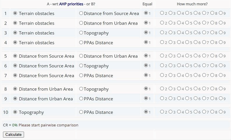
Figure 4
Questionnaire applied to researchers.
Source: The authors (2023).
The platform played an important role in facilitating data acquisition and the reliability of response consistencies. The platform only allowed the generation of results with an uncertainty coefficient of less than 5%. For results that exceeded this value, the platform suggested adjusting the applied weights. The central values of the matrix are in accordance with the methodology proposed by the online AHP platform, which uses Saaty's method (Saaty, 1990) for generating the weights.
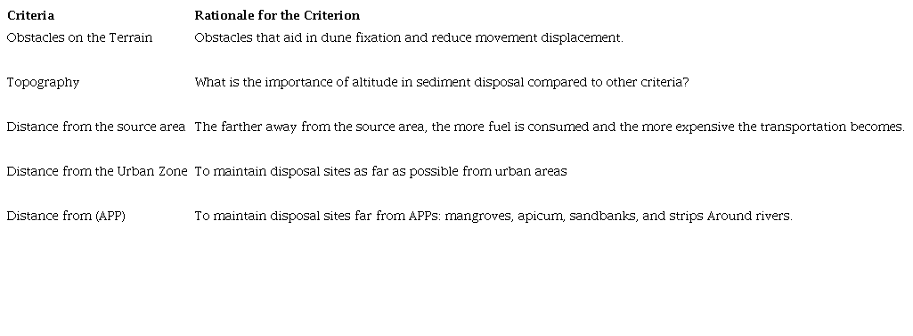
In a table, the researchers used their experiences to order the criteria by importance. They were shown the criteria in pairs and asked which is more important for the creation of dump sites from one (equal importance) to nine (criterion A is extremely important in relation to B). The variation between maximum and minimum is based on Saaty's scale (Saaty, 1990), where conceptual judgment should be primary, followed by conversion to numerical scale to record it in the matrix. The criteria used in this study are listed in Table 1.
Source: The authors (2023).
AHP Method and Multicriteria Analysis of Locational Feasibility
The elements constituting the proposed criteria were verified using QGIS 3.28 software. Urban areas, source areas, terrain obstacles, and APPs were identified and vectorized. The topography criterion was defined using a digital elevation model obtained from the LIDAR database for the Ceará littoral area, collected in 2013.
After vectorization, the shapes were transformed into rasters, in which the proximity tool (distance raster) was used to generate a raster proximity map indicating the distance from the center of each pixel to the center of the nearest pixel, which was identified as the target pixel.
When the proximity process was applied, the raster was rescaled to vary from zero to one. With zero defined as “bad” and one as “good.” The definitions of “good” or “bad” were based on the environmental conditions and how each criterion was established. The aptitude calculation stages were arranged as shown in Figure 5.
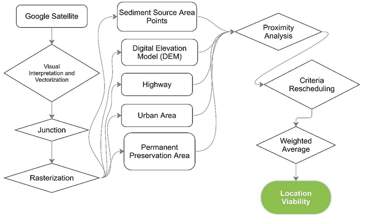
Figure 5
Methodological steps for calculating the sediment disposal suitability areas.
Source: The authors (2023).
The last step involved creating a raster from the weighted average in the raster calculator, where each rescaled raster was multiplied by its respective weight and added to the other criteria using the same operation. The result was a raster that presents more and less suitable areas for sedimentary deposition sites according to established criteria and weights, that is, the locational viability of the study area.
RESULTS AND DISCUSSION
Relative importance of criteria
All six researchers responded to the questionnaire and the weights of the criteria obtained from the AHP calculator platform showed that the distance from APPs had the highest weight of 0.33. However, the criterion for obstacles on the terrain yielded the lowest weight of 0.12. The criteria that showed the highest convergence of the results were obstacles to the terrain and topography, which had a low degree of importance. The most divergent responses were obtained for the criteria of distance from the source area (between 0.02 and 0.37), distance from APPs (between 0.12 and 0.37), and distance from the urban area (between 0.13 and 0.52; Figure 6).
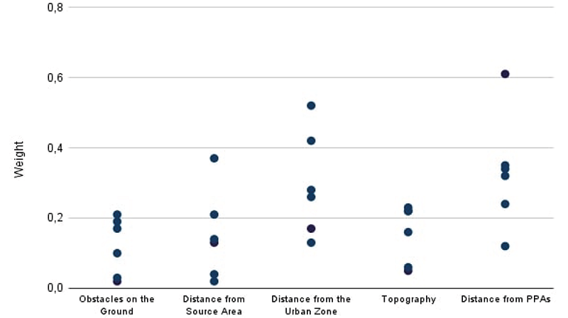
Figure 6
Weights assigned by consulted experts to each suitability criterion for sediment deposition.
Source: The authors (2023).
Table 2 lists the average weights defined based on the degree of importance of each criterion according to the responses obtained on the AHP Online System platform. The maximum value was 0.61, for the distance from APPs, and the minimum value was 0.01, for obstacles on the terrain.

Source: The authors (2023).
Determination of suitable locations for sediment disposal
After obtaining the weights and vectorization of the criteria in the study area, it was possible to create raster files for each indicated criterion and generate a raster from the operation between all criteria. Figure 7 shows the areas with the highest and lowest suitability for the creation of waste disposal sites in the municipality of Barroquinha and the already existing points of disposal.
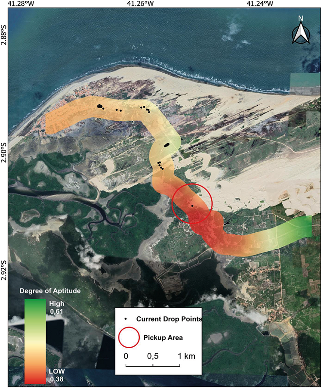
Figure 7
Areas with greater suitability for the creation of disposal sites.
Source: Google Earth Pro (2023). Elaborated by the authors (2023).
The areas that present the best suitability were further from urban and APPs. There were also areas of good suitability near the dune movement scars, agreeing with the established environmental context of the region.
By analyzing the areas with the lowest suitability and comparing them with the already mapped disposal points, we can observe that a large proportion of disposals are being carried out in vulnerable areas close to the urban zone and the Bitupitá community and in APPs such as apicuns and mangroves.
Kazuva et al. (2021) used this multicriterial method to determine the locations of solid waste landfills in Dar es Salaam, Tanzania. Tercan et al. (2021) used this method as the basis for determining sustainable areas for the implementation of solar panel fields.
Feasibility analysis of the disposal sectors
To understand more broadly the problems caused by sediments deposited in inadequate locations, this study identified and mapped, in the field, the points where sediments from the dune field were dumped excess. Along the CE-187 highway, 45 sediment deposition points were identified between the municipal headquarters and Bitupitá under different environmental conditions.
The areas used for deposition were divided into five sectors: S1, located in the northern portion of the highway, close to the urban area and apicuns; S2, comprising deposits made near the Sewage Treatment Plant (STP). S3 and S4, comprising fixed deposition areas close to vegetation on the edges of the highway. S5, comprising constant burying of the highway by dune sediments. S5 is the source area, from which the sediment is removed and deposited in other sectors (Figure 8).
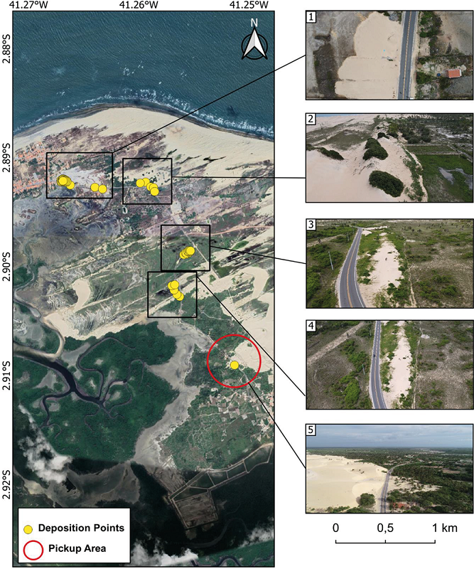
Figure 8
Sediment deposition point along CE-187, grouped into sectors: S1, S2, S3, S4, and S5.
Source: Google Earth Pro (2023). Elaborated by the authors (2023).
Figure 8 shows the area of corral deposition in apicum environments and near residences, where sediments are loose and suffer from transport agents, mainly wind transport. In S2 (Figure 5), these sediments were deposited next to a STP, in a low-lying area in the presence of water and organic matter. At this location, vegetation developed on the dunes, which helped in sediment fixation and stabilized the dunes.
S3 and S4 have similar characteristics largely because of their proximity. In these two sectors, there is evidence of displacement scars from the dune fields, making them an environment that previously had dunes and is currently without sediment. The sediments deposited there are in the process of fixation by vegetation.
In S5, areas requiring more frequent sediment removal were identified. In this area, sediments invade CE-187, hindering the movement of people and services, mainly affecting the district of Bitupitá, as the highway is the only access route to the municipal headquarters. The sediments that fall on asphalt are remobilized on the other side of the highway or deposited along the CE-187. The municipality of Barroquinha has been constantly performing this remobilization action, especially in drier months with a high wind incidence.
The degree of suitability of each currently used sector was identified, where values closer to 0 represent low suitability and those closer to 1 represent higher suitability. S2, S3, and S4 (Figure 5) exhibited the highest suitability for sediment deposition. The results of the suitability analysis model proposed in this study corroborate field observations, as the presence of vegetation-fixed dunes was observed in these three sectors. The presence of vegetation reduces the risk of buried highways and urban areas being buried (Guo et al., 2020) (Figure 9).
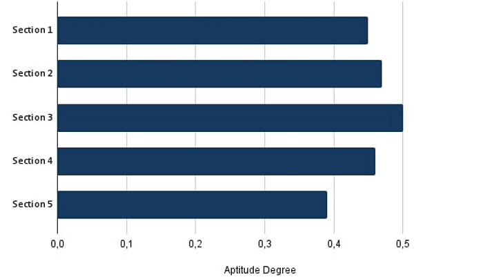
Figure 9
Average suitability for sediment deposition by sectors.
Source: The authors (2023).
S1 and S5 presented lower suitability indices, with S1 being the closest to the urban and beach areas. S5 had the highest amount of loose sediments, which constantly advances and buries the highway.
CONCLUSIONS
The amount of sediment, wind intensity, and natural or anthropogenic obstacles on the surface contribute to the creation of extensive dune fields. Coastal environment urbanization in certain areas without adequate planning increases the risk of burial by sand dunes. Therefore, it is necessary to study these areas, establish measures that can initially identify problems, and propose suitable locations for sediment disposal.
In Barroquinha, the most viable locations for the creation of disposal sites were those farthest from urban and APPs. S2, S3, and S4 presented a good sediment fixation response, in agreement with the locational viability model. The areas with the highest aptitude presented by the model were the farthest from protected and urban areas, where sediment is not currently being deposited.
The findings of this research contribute to the discussion on the process of burying urban infrastructure and has important implications for coastal and urban planning in coastal zones. The research presented here will be an integral part of the Regional Contingency Plan for Incidents and for assessing environmental impact risk in the coastal zones of Ceará, within the Plan of Action against the burial of infrastructure by dune fields. In addition, it will contribute to policy created by the project Programa Cientista Chefe Meio Ambiente: Ciência e Inovação em Políticas Públicas (Project Environment Chief Scientist Program: Science and Innovation in Public Policies). The Chief Scientist Program aims to bridge the academic community and public administration. Through this initiative, teams of researchers are working in the most strategic departments or agencies of the Ceará State Government to identify science, technology, and innovation solutions that can be implemented to improve services, thereby enhancing the quality of life for the population.
The projects and research teams are determined based on the needs of the Ceará State Government agencies. Each team is coordinated by a chief scientist whose selection or nomination follows criteria such as scientific output, academic background, and affiliation with high-level research centers.
ACKNOWLEDGEMENTS
The authors would like grateful the FUNCAP/SEMA for Project Programa Cientista Chefe Meio Ambiente: Ciência e Inovação em Políticas Públicas (Environment Chief Scientist Program: Science and Innovation in Public Policies) - Subprojects Planejamento Costeiro e Marinho do Ceará (Coastal and Marine Planning of Ceará) and Sistema de Informações Geográficas (SIG) Ambiental do Ceará (Environmental Geographic Information System (GIS) of Ceará). Additionally, we acknowledge the FUNCAP to projects (FCT AAC No. 02/SAICT/2017, PS1-00186-00333.01.00/21, UNI-0210-00736.01.00/23). Too would like to thank the Conselho Nacional de Desenvolvimento Científico e Tecnológico - CNPq (National Council for Scientific and Technological Development - CNPq)Project N◦. 420516/2022-0, CNPq Productivity PQ 309102/2022-7). Too would like to thank the Instituto Federal do Rio Grande do Sul - IFRS (Federal Institute of Rio Grande do Sul - IFRS) and the Laboratório de Geologia e Geomorfologia Costeira e Oceânica - LGCO/Universidade Estadual do Ceará - UECE (Laboratory of Coastal and Oceanic Geology and Geomorphology - LGCO/State University of Ceará - UECE) for logistical assistance and access to laboratories.
REFERENCES
BAAS, A. C. W. Complex systems in aeolian geomorphology. Binghamton Special Issue of Geomorphology, 91:311-331, 2007. Doi: 10.1016/j.geomorph.2007.04.012
CANTELON, J. A.; GUIMOND, J. A.; ROBINSON, C. E.; MICHAEL, H. A.; KURYLYK, B. L. Vertical saltwater intrusion in coastal aquifers driven by episodic flooding: A review. Water Resources Research, p. 1-25, 2022. Doi: 10.1029/2022WR032614
CLAUDINO-SALES, V.; CARVALHO, A. M. Dinâmica Costeira Controlada por Promontórios no Estado do Ceará, Nordeste do Brasil. Geociências, v. 33, n. 4, p.579-595, 2014. Available: https://www.periodicos.rc.biblioteca.unesp.br/index.php/geociencias/article/view/9504. Accessed on: mar. 14, 2023.
GOOGLE. Google Earth Pro. Versão 2023. Disponível em: https://www.google.com/earth/. Accessed on: feb. 23, 2023.
GUO, J. J.; GONG, X.W.; FANG, L. D.; JIANG, D. M.; ALA, M.; BUCCI, S. J.; SCHOLZ, F. G.; GOLDSTEIN, G.; HAO, G. Y. Switching of dominant positions between two sand-fixing shrub species during the dune revegetation process is underlain by their contrasting xylem hydraulics and water-use strategies. Land Degradation and Development, v. 31, n. 10, p. 1195-1205, 2020. Doi: 10.1002/ldr.3493
IBGE. Manual do Usuário: Posicionamento Por Ponto Preciso. 2009. Available: http://www.ibge.gov.br/home/geociencias/geodesia/ppp/ manual_ppp.pdf. Acessed on: July 03, 2024
JENNINGS, S.; LOCKIE, S. Democratisation and capacity building in coastal zone decision-making in Australia the application of stakeholder analysis and social mapping. Gloucester Point, Virginia, USA: Virginia Institute of Marine Science; 2002, p.1-5. Available: http://cdc.fish.ku.ac.th/czap_website/abstracts/lockie.pdf. Acessed on: Jun. 21, 2023.
JUNIOR, W. C. G.; FERNANDES, D.; ALENCAR CASTRO, J. W. Analysis of physical and dynamic variables by Coastal Vulnerability Index (CVI) in Formosa Bay cove, Lagos Fluminense Region - Rio de Janeiro State. Revista Brasileira de Geomorfologia, v. 23, n. 4, p. 1812-1833, 2022. Doi: 10.20502/rbg.v23i4.2144
KAZUVA, E.; ZHANG, J.; TONG, Z.; LIU, X. P; MEMON, S.; MHACHE, E. GIS- and MCD-based suitability assessment for optimized location of solid waste landfills in Dar es Salaam, Tanzania. Environmental Science and Pollution Research, v. 28, n. 9, p. 11259-11278, 2021. Doi: 10.1007/s11356-020-11213-0
MARTÍNEZ, M. L.; GALLEGO-FERNÁNDEZ, J. B.; HESP, P. A. Restoration of Coastal Dunes. Springer Series on Environmental Management, p. 307-321, 2013. Doi: 10.1007/978-3-642-33445-0
MCKEE, E. D. A Study of Global Sand Seas. University Press of the Pacific. 440 p. 2004. Doi: 10.3133/pp1052
MORAES, A. C. R. Contribuições para a gestão da zona costeira do Brasil: Elementos para uma geografia do litoral brasileiro. São Paulo: Annablume, 2007.
NETO, A. R. X; MORAIS, J. O.; PINHEIRO, L.S. Modificações na geomorfologia marinha a partir de estruturas portuárias: o caso do Mucuripe, Fortaleza/CE. Geosciences, v. 37, n. 4, p. 793-805, 2018. Doi: 10.5016/geociencias.v37i4.12597
ROCHA, C. D. S.; VASCONCELOS, F. P.; AMARAL, D. N.; CASEMIRO, M. B.; BARRA, O. A. O. Vulnerabilidade socioambiental como base para a gestão costeira no município de Paracuru - Ceará. Revista Brasileira de Geografia Física, v. 13, n. 6, p. 2820, 2020. Doi: 10.26848/rbgf.v13.6.p2820-2839
ROCHA, M. N.; PINHEIRO, L. S.; MORAIS, J. O. Avaliação dos parâmetros meteorológicos atuantes na migração dos campos de dunas móveis setentrionais da planície costeira de Paracuru, Ceará, Brasil. Revista Geociências, v. 39, n. 2000, p. 437-446, 2020. Doi: 10.5016/geociencias.v39i2.12676
RUZ, M.-H.; MEUR-FEREC, C. Influence of high water levels on aeolian sand transport: upper beach/dune evolution on a macrotidal coast, Wissant Bay, Northern France. Geomorphology, v. 60, p. 73-87, 2004. Doi: 10.1016/j.geomorph.2003.07.011
OROPEZA-OROZCO, O.; SOMMER-CERVANTES, I.; CARLOS-GÓMEZ, J.; PRECIADO-LÓPEZ, J. C.; ORTIZ-PÉREZ, M. A.; LOPEZ-PORTILLO, J. Assessment of vulnerability and integrated management of coastal dunes in Veracruz, Mexico. Coastal Management, v. 39, n. 5, p. 492-514, 2011. Doi: 10.1080/08920753.2011.598817
ÖZKAN, B.; ÖZCEYLAN, E.; SARIÇIÇEK, İ. GIS-based MCDM modeling for landfill site suitability analysis: a comprehensive review of the literature. Environmental Science Pollution Research. v. 26, n. 30, p. 30711-30730, 2019. Doi: 10.1007/s11356-019-06298-1
PYE, K.; TSOAR, H. Aeolian Sand and Sand Dunes. Springer Berlin Heidelberg, 396 p. 2009. Doi: 10.1007/978-3-540-85910-9
RYAN, S.; NIMICK, E. Multi-Criteria Decision Analysis and GIS. Story Maps Arcgis. 2019. https://storymaps.arcgis.com/stories/b60b7399f6944bca86d1be6616c178cf
SAATY, T. L. How to make a decision: The analytic hierarchy process. European Journal of Operational Research, v. 48, n. 1, p. 9-26, 1990. Doi: 10.1016/0377-2217(90)90057-I
SANTOS, R. F. Planejamento ambiental. São Paulo: Oficina de Texto, 2004. 184 p.
SHERMAN, D. J.; BAUER, B. O. Dynamics of beach-dune systems. Progress in Physical Geography, v. 17, p. 413-447, 1993. Doi: 10.1177/030913339301700402
SILVEIRA, I. R. L.; FERNANDES, D.; CABRAL, C. L.; OLIVEIRA, D. M. V.; JUNIOR, W. C. G.; CASTRO, J. W. A. Dinâmica das Dunas Escalonares Transgressivas Sobre a Região do Peró - Cabo Frio, Rio de Janeiro. Revista Brasileira de Geomorfologia . v. 22, n. 4. 2021. Doi: 10.20502/rbg.v22i4.2041
TERCAN, E.; EYMEN, A.; URFALI, T.; SARACOGLU, B. O. A sustainable framework for spatial planning of photovoltaic solar farms using GIS and multi-criteria assessment approach in Central Anatolia, Turkey. Land Use Policy, v. 102, n. 2020, 2021. Doi: 10.1016/j.landusepol.2020.105272
VALENTE, R. O. A. Definição de áreas prioritárias para a conservação e preservação florestal por meio da abordagem multicritério em ambiente SIG. 2005. 121 f. Tese (Doutorado em Recursos Florestais) - Escola Superior de Agricultura "Luiz de Queiroz", Universidade de São Paulo, Piracicaba, 2005. Available: https://teses.usp.br/teses/disponiveis/11/11150/tde-15062005-154402/pt-br.php. Acessed on: may. 10, 2023.
VETTORAZZI, C. A. Avaliação multicritério, em ambiente SIG, na definição de área prioritárias a restauração florestal visando à conservação dos recursos hídricos, 2006. 151 f. Tese (Livre Docência em Topografia) - Escola Superior de “Luiz de Queiroz”, Universidade de São Paulo, Piracicaba. 2006. Available: https://teses.usp.br/teses/disponiveis/livredocencia/11/tde-06072007-103043/pt-br.php. Accessed on: may. 18, 2023.