COMUNICACIONES
FACTORS INFLUENCING THE CORRECT POSITIONING OF OFFSHORE JACK UP RIGS IN THE COLOMBIAN CARIBBEAN SEA
FACTORES QUE INFLUYEN EN EL CORRECTO POSICIONAMIENTO DE PLATAFORMAS OFFSHORE TIPO JACK UP EN EL MAR CARIBE COLOMBIANO
FATORES QUE INFLUEM NO CORRETO POSICIONAMENTO DE PLATAFORMAS OFFSHORE TIPO JACK UP NO MAR CARIBE COLOMBIANO
FACTORS INFLUENCING THE CORRECT POSITIONING OF OFFSHORE JACK UP RIGS IN THE COLOMBIAN CARIBBEAN SEA
Interciencia, vol. 43, no. 2, pp. 120-124, 2018
Asociación Interciencia
Received: 10/02/2017
Accepted: 31/01/2018
Abstract: The positioning of offshore self-elevating (jack-up) type platforms involves the development of a series of demanding activities and processes. Among them are included the analysis of Geohazards that may be present above and below sea level, stability analysis and the historical oceanography study of the area of interest. The integration of this information will allow the selection of the best site for the positioning of the jack-up rig. The paper describes the methodology for the analysis of the stability in these type of platforms, which comprises the following stages: site survey analysis, geotechnical analysis and oceanographic analysis, in the same way as the activities that are embedded in each of them were established. They will allow to study and to evaluate present conditions on and under the seabed, identifying the main risks that may represent unsafe conditions for the positioning and operation of the platform. Finally, the analysis of a particular case of a typical study in the Colombian Caribbean Sea is carried in a conceptual manner; in this case a specific methodology is applied and the integration of the information obtained in each of the project stages results in the application of an evaluation and identification of the risks presented in the study area, so as to select the best place for the correct positioning of the platform.
Keywords: Caribbean Sea, Jack-Up Rig, Offshore, Seabed.
Resumen: El posicionamiento de las plataformas de perforación offshore tipo auto-elevables (jack up) implica la realización de una serie de actividades y procesos; entre ellos, el análisis de amenazas que pueden estar presentes sobre y bajo el nivel del mar, análisis de estabilidad y análisis histórico de la oceanografía en el área de interés. La integración de esta información permitirá seleccionar el mejor sitio donde se posicionará la plataforma auto-elevable. El proyecto propone la metodología para el análisis de estabilidad de este tipo de plataformas, que contempla las siguientes etapas: análisis site survey, análisis geotécnico y análisis oceanográfico, de igual forma que se establecieron las actividades inmersas en cada etapa, las cuales permitirán estudiar y evaluar las condiciones presentes sobre y bajo el suelo marino, identificando los principales riesgos que puedan representar condiciones inseguras para el posicionamiento y operación de la plataforma. Finalmente se realizó el análisis de manera conceptual de un caso particular de estudio típico del Mar Caribe colombiano, mediante la aplicación de la metodología y la integración de la información obtenida en cada una de las etapas, permitiendo evaluar e identificar los riesgos que se encontraban presentes en el área de estudio, para seleccionar el mejor sitio para el correcto posicionamiento de la plataforma.
Palabras clave: Mar Caribe, Rack Jack-Up, Costa afuera, Fondo del mar.
Resumo: O posicionamento das plataformas de perfuração offshore tipo auto-eleváveis (jack up) implica a realização de uma série de atividades e processos; entre eles, a análise de ameaças que podem estar presentes acima e abaixo do nivel do mar, análise de estabilidade e análise histórica da oceanografia na área de interesse. A integração desta informação permitirá seleccionar o melhor local onde se posicionará a plataforma auto-elevável. O projeto propõe a metodologia para a análise de estabilidade deste tipo de plataformas, que contempla as seguintes etapas: análisis site survey, análise geotécnica e análise oceanográfica, de igual forma que se estableceram as atividades imersas em cada etapa, as quais permitirão estudar e avaliar as condições presentes sobre e sob o solo marinho, identificando os principais riscos que possam representar condições inseguras para o posicionamento e operação da plataforma. Finalmente se realizou a análise de maneira conceitual de um caso particular de estudo típico do Mar Caribe colombiano, mediante a aplicação da metodologia e a integração da informação obtida em cada uma das etapas, permitindo avaliar e identificar os riscos que se encontravam presentes na área de estudo, para selecionar o melhor local para o correto posicionamento da plataforma.
Palavras-chave: Mar do Caribe, Plataforma de elevação, No mar, Solo oceânico.
Introduction
Given the present energy needs, the oil and gas industry in Colombia has had the need to explore new fields for hydrocarbon exploitation. Currently, offshore exploration in the country is almost nil, and research has to be carried out on new deepwater beds that will allow to increase hydrocarbon reserves and technological development in the country. Several factors permit to decide on the selecting of the most appropriate platform for offshore drilling. These factors depend mainly on the geographical location of the well that will be drilled, and some of them are: seabed characteristics, environmental conditions, waves, ocean currents and depth of the water layer. Similarly, there are a great variety of marine platforms used for exploration, exploitation and production of hydrocarbon in offshore fields; the most used types being fixed (steel jacket, sea star and spar) or mobile (jack-up, semi-submersible and drilling ship). This paper is limited to the study of the characteristics of the soil and oceanographic conditions for the correct positioning of self-elevating (jack-up) platforms (Figure 1, left).
The jack-up rig used for exploration activities and drilling operations in waters depths of up to 180m are usually of rectangular or triangular shape and must be towed to the operating site. With the help of motors in each one of its legs, their height can be adjusted as needed, and they rest firmly on the seabed (API, 2000; SNAME, 2002).
This research aims to describe the geophysical, geotechnical and oceanographic studies required of the areas where the proper positioning of the jack-up rig is to be carried out, and to identify shallow and oceanographic geological risks that may represent unsafe conditions for people, environment and operation (Osbourne and Paisley, 2002). The information collected in each of the studies, after further analysis, will determine soil characteristics and oceanographic conditions of the area. This will define the safest place for positioning the platform and therefore mitigate risks of geological or geotechnical origin that may endanger the infrastructure to be developed.
Methodology
Site survey analysis
Integration and analysis of the data acquired with the different instruments, will enable the generation of a real geological model of the sea-bed. This information will be useful enough to identify and map geological hazards that can represent unsafe conditions during positioning of the platform and the drilling of the well. Afterwards, the best location where the jack-up rig will be positioned and thus ensure the overall safety of the structure will be selected (Figure 1, right).
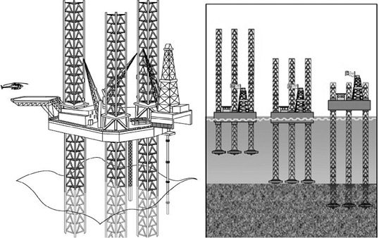
Figure 1
Jack up rig (left) and positioning stages of the self-lifting platform (right).
Sources: Petroleum Support (2013) for the left, and Parra (2012) for the right.
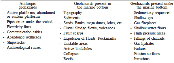
It is necessary to generate inputs for the later phases of the analysis, such as images showing a view of the seabed and any object on it, seabed profiles, subsurface analysis, maps of geological risks found in the study area, as well as a report with the correspondent recommendations. This study may identify some geohazards from the seabed up to the first meters of subsurface (~500m), which could anticipate unsafe conditions for the platform (Table I).
Geotechnical analysis
This analysis is performed so as to know the types of sediments that form the soil of the area of interest, i.e. the geotechnical properties, composition and origin. Is necessary to evaluate the behavior of the soil to be able to establish the load capacity of the seabed. The capacity to withstand the stresses associated with the weight of the platform, the stresses generated during the drilling of the well and establishing the length of penetration of the jack-up rig’s legs at the bottom. This analysis should be done systemically, trying to cover the following aspects: 1) Study: of geotechnical information. 2) Acquisition of geotechnical information: Coordinates selection for the drillings, execution of CPT (cone penetration test), laboratory analysis on board and processing of geotechnical information. 3) Interpretation of geotechnical information: Geo technical characterization of the seabed, calculation of bearing capacity of the seabed (Figure 1, right), estimation of the depth of penetration of the jack-up legs.
Oceanographic analysis
Generally, a historical study of the site conditions is done to obtain more detailed and accurate information of the studied area. The information must be processed, analyzed and interpreted, in order to obtain the minimum and maximum values (daily, monthly and annual) of the different parameters to be measured. These permit the identification of dangerous weather seasons that occur in the study area and the necessity to act on the platform because of the winds and their direction.
Results
Site survey
Bathymetry will help identify in a first instance the morphology of the sea-bed and some of the geological hazards presents in the area. In Figure 2, the bathymetric map of the study area is shown. The topographic conditions of the seabed can be seen, as well as the clear demarcation of the zones corresponding to the continental platform, slope and abyssal floor. The grayscale represents graphically the respective depths in each area, where the light gray represents the shallowest area and the dark gray the deepest area, ranging from -37m to nearly -1000m. In the figure are also shown the theoretically calculated slopes in each of the areas but, then, different inclinations are really needed. A slope map that allows having a better understanding of the area is made (Figure 3, right). In this way, following the ranges shown in the figure, is how the areas with the highest probability of landslide risk can be quantitatively established.
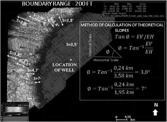
Figure 2
Bathymetric map - identification of submarine canyons and theoretical calculation of slopes.
Given the above, the dark areas in Figure 3 (left) are related to areas of side slope, in which dissections of the sub-marine channels are found and that represent a high risk of slipping. On the other hand, at regional level, the platform area shows soft slopes where, under this provision, a platform could be located.
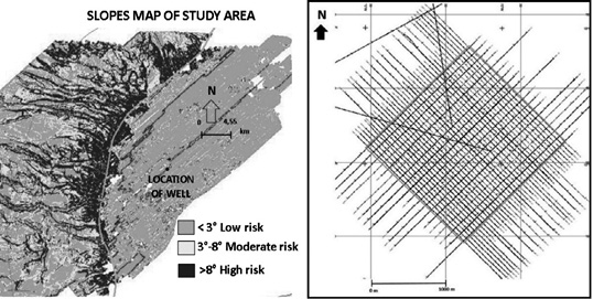
Figure 3
Map of slopes from the study area and design of the acquisition grid of geophysical information.
As mentioned in the methodology section it is necessary to focus on the point of perforation, for which is necessary the acquisition of geophysical data of high resolution in an area of 3×3km around the well. using techniques, such as echo sounding, side scan sonar, and seismic reflection. The acquisition of information is very important, since it allows a detailed analysis of a specific area, which for the present case covers 9km2 around the well location to be drilled and where the self-elevating platform would be positioned according to the parameters of the IOGP (2013) (Figure 3, right). The main objective of this study is to identify geohazards present near the perforation site which may pose a risk to the operation, the environment and human life.
High-resolution bathymetry allows detailing an area that is between 35 and 47m from the water table; is a shallow zone and confirms the operability of a jack-up type platform. Through the side scan sonar equipment the irregularities present on the surface of the seabed are revealed more clearly, as shown in Figure 4. Elongated landforms ~4m long, like craters generated by shallow gas up to 30m., also called ‘pockmarks’ can be clearly seen. Additionally, characteristics and monticules typical of carbonate accumulations along the platform are also observed. These carbonates points can become favorable zones for sampling and for verification of gas presence.
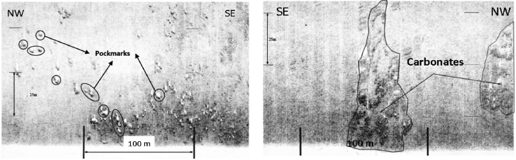
Figure 4
Side scan sonar showing irregularities in the seabed (pockmarks and possible carbonates).
Once the features on the surface have been established, it is vitally important to know and analyze the first few meters of subsurface to this end, this the sub-bottom profile shows the evidences of possible gas. For our case, in Figure 5 (left) is evidenced the probability of having shallow gas that is found at depths of less than 30m and that is ascending towards the surface. Similarly, seismic evidences of feathers of gas present in the area are shown and many of them can be related to the possible carbonates and pockmarks previously identified. The effect of shallow gas is to generate high pressures that can affect operation and safety.
As a result of the study site survey, the zoning map is presented in Figure 5 (right). The map shows the different risks or geohazards that were interpreted both on the surface of the seabed and in the first 30 to 50m below it, considering the following: 1) the area around the well site shows a low probability of landslides (slopes map), 2) water depth of 40m in the well location, 3) areas with evidence of superficial gas, and 4) a great risk of finding shallow gas at less than 30m deep. As shown in Figure 5 (right), the majority of the area presents risk of shallow gas, including the position of the well. Thus, it is recommended to inform drilling engineers to take mitigation measures or to change the well site on surface 200m SW, where there is no evidence of geohazards (white area).
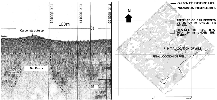
Figure 5
Evidences of gas presence and risk zoning in the study area.
Geotechnical analysis
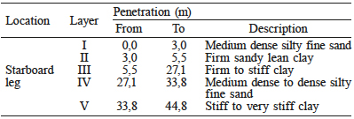
It is important to note that sampling must be performed in the location for each one of the legs of the platform, just as it is important to define other coordinates (back up), for the case that during the sampling and processing of the information from the in-situ testing, evidence of geological risk is found, or if the minimum bearing capacity is not found (Brinch, 1970; Reardon, 1986; Fugro, 1987; DNV, 1992). According to the results obtained by the CPT performed in-situ, a soil stratigraphy established in one of the perforations is presented in Table II.
It is also important to indicate the dimensions for which the calculation of the spudcan penetration was performed (Figure 6). The area that will be in contact with the ground and that will be responsible for the transmission of forces can be determined from these dimensions (Young et al., 1984; Goedemoed and Kolk, 1994; Kolk and Legein, 1994).
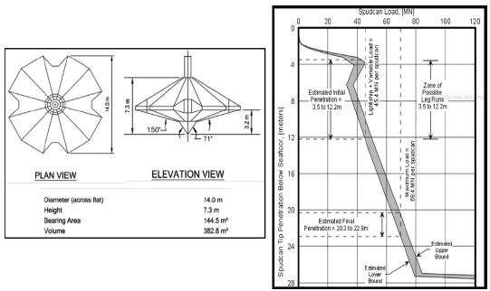
Figure 6
Dimensions and penetration curve of the spudcan.
The analysis performed of the penetration at start and end of the spudcan, calculated with a minimum load of 45,4-MN (3,5 to 12,2m of startboard leg) and a maximum load of 69,4-MN (20,3 to 22,9m of starboard leg) per spudcan (Fugro, 1990; Geer et al., 2000) is summarized, as obtained with the penetration curve of the spudcan that can be observed in Figure 6 (right).
Oceanographic analysis
This analysis was performed based on oceanographic and meteorological information from the Colombian Caribbean Sea (CIOH, 2015). Bad weather seasons for the development of the different studies were identified. According to the information recorded by the CIOH (2015), four climatic periods are evidenced in the site, as follows:
Dry season: (December to April). It is characterized by strong winds from the N-NE sector and by weak and scarce rain. During this time, the so called ‘swells’ may occur, caused by the incursion of polar fronts from the northern hemisphere into the Caribbean Sea.
Rainy season: (April to November). It is characterized by weak winds and heavy rains. At this time often occur the so called ‘tropical cyclones’ (hurricanes), which can increase rainfall throughout the Colombian Caribbean.
Humid season: (August to November). The origin of the winds is better associated with the intertropical convergence zone than with the trade winds, reaching winds in direction W-SW during this months with speeds generally ranging between 5 to 10 knots. This weakness of the winds is the reason that the wave height does not exceed 2,5m during this months in the northern Caribbean coast.
Transition season: (between the second fortnight of May to July). This season is characterized by weak winds of variable direction. During this period, the so-called ‘indian summer’ develops, characterized by the increase of room temperature, relative humidity, clear skies, increased solar brightness and, at the same time, scattered showers may occur. The graph for maximum wave height recorded by the CIOH in a period of one year is shown in Figure 7.
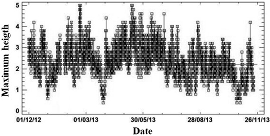
Figure 7
Maximum wave height in the colombian Caribbean Sea.
Once all geological risks presented in the study area were analyzed, the areas where there is less likelihood of risks were established. That is how the final coordinates where geotechnical perforations should be conducted were defined. It is important to highlight that at the location of each of the legs of the platform sampling should be enhanced.
Conclusions
The proposed methodology for the analysis of the stability of a platform establishes that the geotechnical study should start once the results obtained from the geophysics study have been finished and interpreted. The selection of the type of platform initially depends on the depth of the water layer in the study area. Self-elevating (jack-up) platforms can operate in water depths of up to 180m. With the geophysical study, it was determined that the sheet of water in the survey site ranges between -37.9 to -42,5m, which means that the use of this equipment is possible.
The forecast of the oceanographic conditions is important for the development of offshore operations, because if they are not properly predicted, a standby can be generated, which would mean an increase in operating costs. The application of the methodology for the analysis of the different studies would ensure meeting the proposed objectives, as this is part of one of the stages of a project going from a theoretical assumption that then leads to the technical implementation.
According to the zoning risk map obtained with the geophysical information, it is established that where the well is to be located, the presence of shallow gas is evident, so it is recommended to move the well 200m to the SW, where there is no presence of gas. Pockmarks, carbonates, shallow gas and geological failures, were the main risks identified in the study area, which represent very high risk conditions to position the platform, so it is recommended to avoid these areas.
REFERENCES
API (2000) Recommended Practice for Planning, Designing and Constructing Fixed Offshore Platforms - Working Stress Design. 21st ed. American Petroleum Institute. Washington, DC, USA.
Brinch J (1970) A revised and extended formula for bearing capacity. Dan. Geotech. Inst. Bull. 28: 5-11.
CIOH (2015) Climatología del Caribe. Centro de Investigaciones Oceanográficas e Hidrográficas. Cartagena, Colombia. http://www.cioh.org.co/meteorologia/Climatologia/ClimatologiaCaribe7.php (Cons. 08/23/2015).
DNV (1992) Foundations. Classification Notes Nº 30.4, Section 8. Det Norske Veritas. Oslo, Norway. pp. 44-51.
Fugro (1987) Foundation Fixity of Jack-up Units. Report of Joint Industry Study organised by Nobel Denton and Associates, Ltd. London, UK.
Fugro (1990) VH, Computer Program for the Calculation of V-H Relation for Spudcan Foundations. Fugro Engineers B.V. Leidschendam, The Netherlands. 198 pp.
Geer DA, Devoy SD, Rapoport V (2000) Effects of soil information on economics of jack-up installation. Offshore Technology Conference (05/01-04/2000). Houston, Texas, USA.
Goedemoed SS, Kolk HJ (1994) JURIG3 - A computer program for jack-up rig leg penetration analyses. Proc. 13th Int. Conf. on Soil Mechanics and Foundation Engineering (01/1994). Vol. 4. Oxford & IBH. New Delhi, India. pp. 1433-1436.
IOGP (2013) Guidelines for the conduct of offshore drilling hazard site surveys. International Association of Oil & Gas Producer. http://www.iogp.org/pubs/373-18-1.pdf (Cons. 23/08/2015).
Kolk HJ, Legein JJ (1994). Punch-through Failure of Independent Jack-up Rig Legs. Proceedings of 8th Int. Conf. on Comp. methods and advances in geomechanics, Siriwardane, H. & Zaman, M. (Ed.).
Offshore Magazine (2011) Worldwide survey of deepwater jack-up rigs. Offshore Mag.http://www.offshore-mag-com/maps-posters.html (Cons. 02/10/2018).
Osbourne JJ, Paisley, JM (2002) SE Asia jack-up punch-throughs: The way forward? Offshore site investigation and geotechnics: Diversity and sustainability. In Cook M et al. (Eds.) Proc. Int. Conf. (11/2002). London, UK. pp. 301-306.
Parra JG (2012) Algunos retos a la ingeniería geotécnica costa afuera en Venezuela. XX Seminario Venezolano de Geotecnia “Desafíos en el Ejercicio de la Geotecnia” (11/08-10/2012). Caracas, Venezuela.
Petroleum Support (2013) We Support your Idea. http://petroleumsupport.com/offshore-drilling/jack-up-rig/ VERIFY URL (Cons. 09/10/2016).
Ramos, N. (2001) Curso Ingeniería Civil: Costa Afuera. http://www.ptolomeo.unam.mx:8080/xmlui/bitstream/handle/132.248.52.100/1503/Tesis.pdf (Cons. 02/10/2018).
Reardon MJ (1986) Review of the geotechnical aspects of jack-up unit operations. Ground Eng. 19: 21-26.
SNAME (2002) Recommended Practice for Site Specific Assessment of Mobile Jack-up Units. 1sted. Rev. 2. Tech. & Research Bulletin, 5-5A. Society of Naval Architects & Marine Engineers. Jersey City, NJ, USA.
Young AG, Remmes BD, Meyer BJ (1984) Foundation performance of offshore jack-up drilling rigs. J. Geotech. Eng. 110: 841-859.
Author notes
Alternative link
https://www.interciencia.net/wp-content/uploads/2018/03/120-RUGE-43_02.pdf (pdf)