Carátula del artículo
Artículos de investigación
Exploring the Forest Structure and Floristic Composition Patterns of the Equatorial Chocó, Esmeraldas Province
Explorando los patrones de estructura del bosque y ecología florística en el Chocó Ecuatorial, provincia de Esmeraldas
 Pablo Lozano plozano.uea.edu.ec
Universidad Estatal Amazónica, Ecuador
Bente Klitgaard
Royal Botanic Gardens, United Kingdom
Walter Palacios
Instituto Nacional de Biodiversidad (INABIO)., Ecuador
Janeth Santiana
Programa REM, Ecuador
Byron Medina
Universidad Central del Ecuador, Ecuador
Carlos Morales
Programa REM, Ecuador
Juan Iglesias
Ministerio del Ambiente, Agua y Transición Ecológica del Ecuador, Ecuador
Colombia Forestal, vol. 28, no. 2, e22624, 2025
Proyecto Curricular de Ingeniería Forestal, Facultad del Medio Ambiente y Recursos Naturales, Universidad Distrital Francisco José de Caldas.
Received: 10 August 2024
Accepted: 31 March 2025
INTRODUCTION
The Chocó bioregion extends from north to south, from western Panama in Central America, crossing the Darién into Colombia, and continuing along the lowlands and Andean slopes of the Colombian and Ecuadorian Pacific Coast in northwestern South America (Gentry, 1982a, 1986; Forero, 1982; Forero & Gentry, 1989). Chocó is the southernmost continuous tropical rainforest on the South American Pacific Coast (Rangel, 2015). In addition, its southern limit is located in the Guayas Province, along the Ecuadorian Pacific Coast (Neill, 1999).
The Chocó Forests are influenced by the El Niño current, which results in higher rainfall, humidity, and warmth levels between December and April (Fiedler, 1992; Fidler & Lavine, 2016). The region is characterized by high annual rainfall, with an average of 5000-7000 mm (Galeano et al., 1998), increasing to an average of 8000 mm in the north (Gentry, 1982a), and up to a maximum of 12 000 mm per year (Sota, 1972, cited by Gentry, 1986). Chocó experiences rainfall throughout the year and maintains an average temperature between 27 (Galeano et al., 1998) and 30 ºC (Blanco, 2009; Blanco et al., 2014).
The Equatorial Chocó encompasses areas below 400 m in elevation within the Cayapas and Esmeraldas watersheds (in the Esmeraldas province of Ecuador), as well as the humid Guayas River watershed, which includes a transition zone to the Jama-Zapotillo Dry Forest (MAE, 2013), also known as the Guayas-Piura Dry Forest (Madsen et al., 2001). The unique Chocó forests also extend to areas within the Andean provinces of Carchi, Pichincha, Cotopaxi, Bolivar, Cañar, and Azuay in Ecuador, particularly in the Andean Foothills below 400 m.
The Chocó Bioregion is recognized as a biodiversity hotspot and is home to approximately 8000-9000 plant species, with 2250 being endemic (Myers et al., 2000; Fagua & Ramsey, 2018). Despite this, less than 25% of the Chocó forests remain intact (Myers et al., 2000). The Equatorial Chocó is continuously threatened by agricultural expansion and the use of fire, and it is also affected by persistent timber logging (Lozano et al., 2022). In Ecuador, less than 5% of the ecosystem remains (MAE, 2015), which implies a significant loss of plant and animal biodiversity as habitats are destroyed (MAE, 2013).
Floristic and structural forest studies in Chocó are gaining importance since they highlight the fragility of these ecosystems and their significance as centers of endemic taxa (Gentry, 1982b, 1982c; Rangel, 2015). Endemism is influenced by this region’s isolation from the Andean Cordillera and the rapid radiation of certain plant groups (Gentry, 1982c; Schley et al., 2018; Pérez-Escobar et al., 2019). Despite the severe lack of knowledge about the Equatorial Chocó in Ecuador, some studies have been conducted to better understand its forest structure and biodiversity (Holdridge, 1947; Harling, 1979; Gentry & Dodson, 1987; Dodson & Gentry, 1991, 1993; Cerón, 1999; Clark et al., 2006; Palacios & Jaramillo, 2016).
Regarding the native forest cover, in 2014, the province of Esmeraldas recorded 823 828 ha (MAE, 2015). It was also one of the provinces with the highest gross deforestation during the 2014-2016 period. The majority of the current data provided by the Ministry of the Environment (for the year 2022) accounts for 747 056 ha covered by native forest (MAATE, 2024), representing an approximate loss of 76 000 ha of forest in eight years. This highlights the importance of conducting floristic studies to strengthen the knowledge of this region’s flora and the conservation, ecological restoration, and sustainable use of its forests and biodiversity.
In this vein, this study contributes to a better understanding of the botanical/forest structure in the Ecuadorian Chocó and its fragile ecosystems.
MATERIALS AND METHODS
Study area
The Esmeraldas province was the area selected for a comparison of the floristic ecology and forest diversity in a diverse equatorial forest of Chocó. This province is located on the western Pacific Coast of Ecuador, with habitats ranging from evergreen lowland forests (0-300 m) to evergreen seasonal piedmont forests in the Chocó Coastal Cordillera (200-400 m) (MAE, 2013). The Canandé Reserve, Cayapas, and Loma Linda were selected as sites for the comparative analysis due to their conservation status. The Canandé Reserve, a protected area with 9000 ha of representative Chocó landscape, located in the parish of Quininde, in the Esmeraldas province of northwest Ecuador (Figure 1), was a key component of the study area. The Canandé Reserve belongs to a network of private forest reserves owned by Fundación JOCOTOCO and has been under formal protection and management since 2000. The Cayapas site is located in the western part of Cotacachi Cayapas National Park, mostly below 100 m in elevation. It has been under formal protection and management by the govern- ment since 1968. Finally, the Loma Linda site is located in an area of intact Chocó forest at an elevation of 60 m, just outside the western boundary of Cotacachi Cayapas National Park.
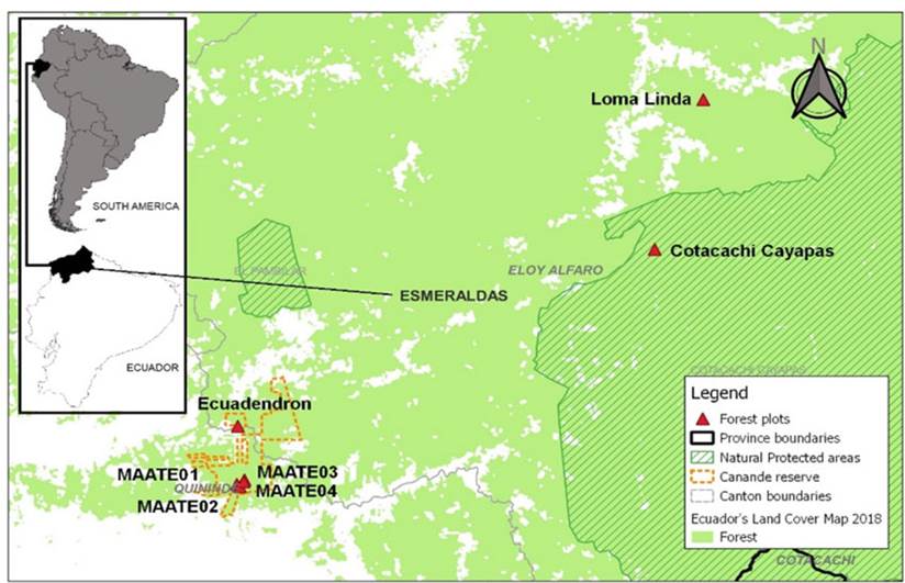 Figure 1
Location of the study area in Ecuador (Equatorial Chocó, Esmeraldas province, and Canandé Reserve), with the distribution of survey plots
Figure 1
Location of the study area in Ecuador (Equatorial Chocó, Esmeraldas province, and Canandé Reserve), with the distribution of survey plots
The selected study area has a moist, tropical climate with temperatures exceeding 30 °C, an average precipitation of 2500-4000 mm per year, and a relative humidity higher than 70% (MAE, 2013). Further inland, the landscape is dominated by the Perhumid Foothills of the Andes, where the multi-stratified forest varies in height from 25 to 30 m, with emergent trees reaching up to 40 m tall. Ecologically, it exhibits a particular flora composition with elements from the Andean slopes of the coastal cordillera, the Chocó Lowlands, and the Lowland Evergreen Montane Forest of the Western Andes (Cerón, 1999).
Data collection and processing
The fieldwork was conducted using a stratified sampling model. Homogeneous plots were selected based on topographic landscape and vegetation (Mateucci & Colma, 1982). Three 1 ha plots (100 x 100 m) and four additional 50 x 50 m plots were established at different elevations (60-450 m) and spatially distributed throughout the Esmeraldas province in Ecuador. Sampling was conducted at different time scales between 1998 and 2020 (Table 1, Figure 1). All trees with a diameter ≥ 10 cm at breast height (DBH) were recorded. Three to four specimens were collected from each tree, and all the vegetative material was coded, dried, and processed in the field. The plant specimens were incorporated into the ECUAMZ herbarium collection and later transported for taxonomical identification at Pontificia Universidad Católica’s herbarium (QCA; Quito, Ecuador), the herbarium of the Ecuadorian Museum of Natural Sciences (QCNE-INABIO), and the the International Herbarium (K) at the Royal Botanic Gardens, Kew, with herbaria abbreviations according to Thiers (2022). The taxonomic review was performed based on the key treatments of the Flora of Ecuador (Holm-Nielsen, 1986), the Catalogue of Vascular Plants of Ecuador (Jorgensen & León-Yánez, 1999), and the Plant List and Tropicos database from the Missouri Botanical Garden (2016). The endemic species categories were regarded as threatened under IUCN (2022) criteria, using relevant sources such as the Red Book of Endemic Plants of Ecuador (León-Yánez et al., 2011), Magnolias of Ecuador: At Risk of Extinction (Vásquez et al., 2016), and online information from the Bioweb (2022).
Table 1
Distribution of plot surface, coordinates, altitude, and establishment date
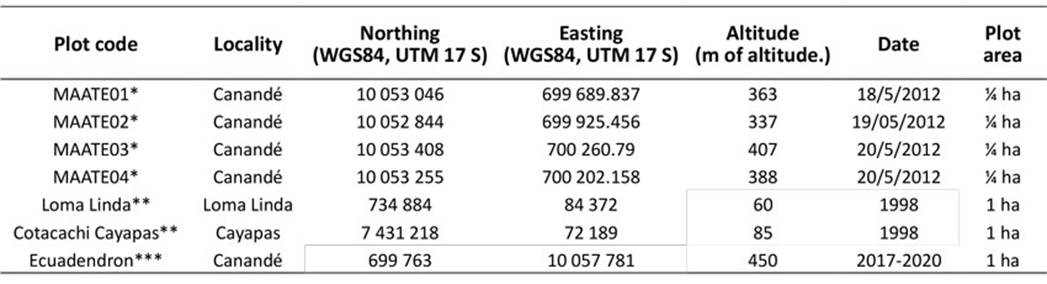 * Vegetation map of Ecuador Project (MAATE); ** Palacios, 1998; ***Lozano et al., 2022
Statistical analysis of plant diversity
Forest structure
A matrix was constructed which included the site, family, scientific name, and DBH (cm) for the recorded individuals of each plot, excluding young individuals and vines. To analyze the forest structure, the DBH was used to calculate the basal area and dominance, as follows:
where:
BA = Basal area expressed in square meters
pi = 3.1416
DBH = Diameter at breast height (cm)
The basal area (BA) is the surface area of a cross-section of the stem or trunk of a tree at a given height above the ground, which is calculated using the DBH. Relative dominance is a measure of abundance and was calculated as a percentage of the BA of a given species compared to the total BA of all species:
where:
BAsp = Basal area of a given species
BAtotal = Sum of the basal area of all species
In addition, the importance value index (IVI) was calculated based on two parameters, i.e., the sum of the relative frequency and the relative dominance, in order to assess the relative ecological importance of each species in the study (Mostacedo & Fredericksen, 2000).
Forest diversity
In this work, the Biodiversity R package (Kindt & Coe, 2005), a graphical user interface for statistical diversity analysis, was employed. To measure the alpha diversity, richness was calculated as the total number of species. In addition, Simpson's reciprocal diversity index was determined as follows (Jost, 2006):
where:
The Simpson inverse index is a measure of the alpha diversity present in a given area. The lower the index, the greater the diversity. The abundance ranking curve was used to analyze patterns of diversity in terms of evenness.
Species accumulation curves are used when comparing species richness in the data when the sample sizes of the subsets are different. To evaluate the sampling efficiency, a sample-based species accumulation curve was used, following Kindt and Coe (2005) and applying rarefaction. This was done in order to determine the differences in the mean number of species per site for various random subsets of the data, seeking to account for the unbalanced sample size. Figure 3 shows the cumulative average of the number of species and the total number of sampled plots.
Non-metric multidimensional scaling (NMDS) was used to measure the beta diversity. This type of analysis has proven to be robust for analyzing plant community data (Minchin, 1987; Martin & Goebel, 2011), as well as for handling data collected through discontinuous sampling (Pyke et al., 2001; Stropp, 2011). NMDS determines a spatial arrangement of samples, such that the distances between the samples in the plots best correspond to dissimilarities in species composition (Lepš & Šmilauer, 1999). This was done based on indices that consider abundance, such as the Bray-Curtis index.
RESULTS
Floristic composition and endemism
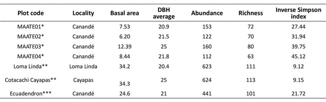
The abundance per hectare.plot-1 ranges from 441 to 624 individual trees, and the number of species of trees ranges between 95 and 112 per hectare. Inland, in the ¼ ha plot (Table 2), the abundance varies between 112 and 160 individual trees, and the number of species between 63 and 80 per hectare. The data show significant differences in relation to plot-size. The palm family (Wettinia quinaria, Iriartea deltoidei, and Socratea exorrhiza), as well as the dicotyledon families Moraceae (Perebea xantochyma), Myristicaceae (Virola reidii), Fabaceae (Ecuadendron acosta-solisianum and Swartzia haughtii), Meliaceae (Guarea polymera, Carapa longiptala), and Malvaceae (Matisia grandiflora), among others, exhibit the highest number of individuals and species (Table 3).
Table 2
Synoptic structural and diversity inputs, richness, and Simpson index for the studied plots
Table 3
List of the ten species with the greatest relative ecological importance in the study according to the IVI
Eight species of trees endemic to Ecuador were recorded, out of which three are critically endangered (CR) (Ecuadendron acosta-solisianum, Magnolia canandeana, and Simira standleyi), four are endangered (EN) (Matisia palenquiana, Carapa longipetala, Sorocea sarcocarpa, and Virola aequatorialis), and one is vulnerable (VU) (Inga silanchensis). Within their distribution, most of the Chocoan Ecuadorian species are mainly threatened (Cornejo, 2011) by habitat loss due to logging and land use changes (Lozano et. al., 2022), leaving only isolated populations in the few remnants of vegetation present in the Coastal Equatorial Chocó region (MAATE, 2024). Ten tree species reported as endemic from the Colombian southern Chocó were recorded in this study. Malvaceae has three endemic species: Herrania balaensis (P. Preuss), Matisia Castano (Triana), and Matisia grandiflora (Little). Another seven species were represented by different families, i.e., Boraginaceae: Tournefortia gigantifolia (Killip ex J.S.Mill); Clusiaceae: Clusia dixonii (Little); Fabaceae: Swartzia haughtii (R.S. Cowan); Melastomataceae: Miconia dapsiliflora (Wurdack); Meliaceae: Guarea cartaguenya (Cuatrec. P. Jorg & C. Ulloa); Olacaceae: Hesiteria pacifica (Ulloa); and Violaceae: Gloeospermum grandifolium (Hekking). These findings are representative of the high endemism of the Chocó Bioregion and corroborate the theory of isolated evolution.
Forest structure
According to our analysis of the relative dominance per BA, the most dominant family is Moraceae (20%). Approximately 90% of the dominance stems from 18 families, seven of which account for over 60%, i.e., Moraceae (20%), Meliaceae (8.99%), Myristicaceae (8.22%), Fabaceae (7.98%), Euphorbiaceae (7.18%), Arecaceae (6.94%), and Burseraceae (5.49%). However, Arecaceae is the most abundant family, particularly in the northeastern part of the study area (Loma Linda and Cotachachi Cayapas). Here, 438 individuals of Wettinia quinaria were recorded among more than 2000 registered individuals, accounting for approximately 7% of the dominance (Figure 2). Out of the 17 species contributing over 50% of the dominance, Brosimum utile contributed 11.64% alone and was recorded in four out of the seven plots. It is worth noting that two individuals of this species also exhibited the highest recorded DBH (116.1 cm).
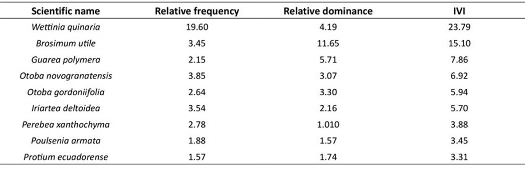 Figure 2
Relative dominance based on the BA of the recorded families in all the plots of the study area
Figure 2
Relative dominance based on the BA of the recorded families in all the plots of the study area
The species accumulation curve showed a linear trend rather than a clear asymptote (Figure 3). This could be due to the high diversity recorded in the study area. The curve suggests that further sampling is needed to fully represent the diversity of the study area, and that there may be new species yet to be discovered.
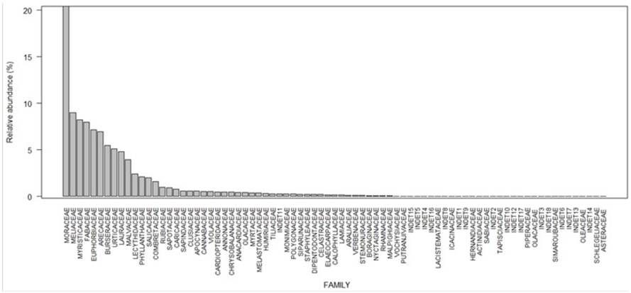 Figure 3
Accumulation curve of the species sampled in all the plots of the study area
Figure 3
Accumulation curve of the species sampled in all the plots of the study area
The rank abundance curve indicates a high level of species richness (Figure 4), albeit with a concentration of highly abundant species, with the palm Wettinia quinaria (Arecaceae) being the most abundant. The curve shows that the distribution of individuals per species is not uniform. It is important to note that 76% of the recorded species are represented by singleton or doubleton species, which contribute significantly to the observed diversity.
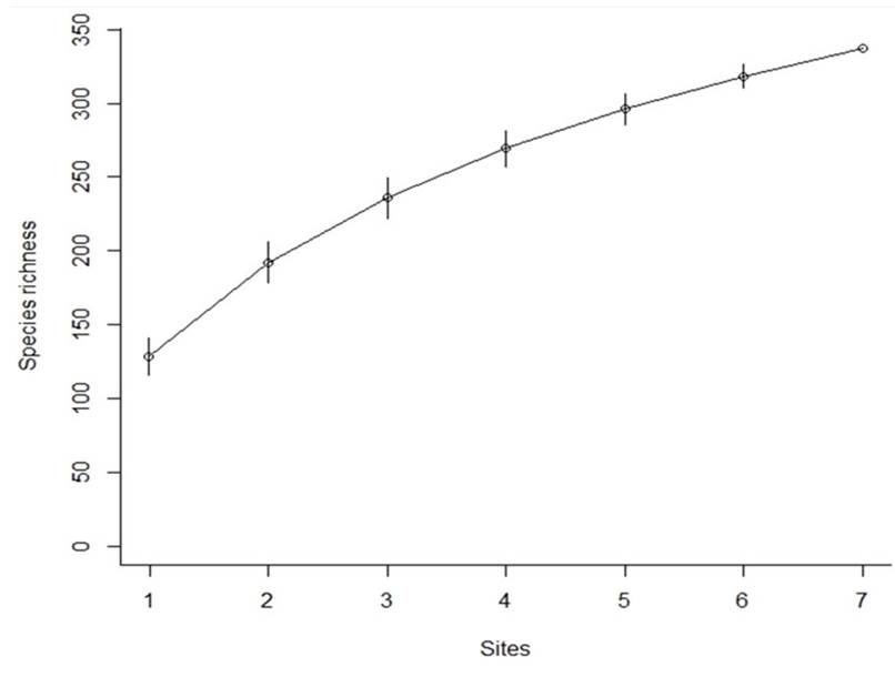 Figure 4
Rank abundance curve of all the species recorded in the study area
Figure 4
Rank abundance curve of all the species recorded in the study area
The observed IVI corresponds to 39 out of 360 species, covering 63% of the total index value. Table 3 lists the ten most important species.
The inverse Simpson diversity index values indicated that, at the local level, the Loma Linda and Cotacachi Cayapas plots exhibit high species diversity (Table 2), as evidenced by their high number of individuals and species richness (Table 3). Among the plots within the Canandé Reserve, there was a remarkable similarity in terms of species diversity, with the Ecuadendron plot, in the northernmost part of the reserve, showing the highest species diversity.
The results of the NMDS analysis, depicted in Figure 5, indicate a high beta diversity in the plots, with several shared species and unique differences in terms of composition. Three distinct groups of similar plots were observed, with Loma Linda and Cotacachi Cayapas situated close to each other and belonging to the lowland group (below 100 m in altitude). The second group included MAATE02, MAATE03, and MAATE04 (altitudes between 337 and 388 m), and the third group consisted of the Ecuadendron and MAATE01 plots (400-450 m in altitude).
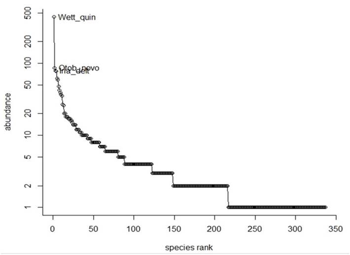 Figure 5
NMDS ordination of the forest plots in the study area.
Figure 5
NMDS ordination of the forest plots in the study area.
The results of the NMDS show an association related to the altitude of the plots, showing proximity of those located in lowlands and on the other hand of those located within the Canandé ecological reserve just near to the Andean foothill, remarking the difference in the floristic diversity of the plots according altitude, also considering the fact that a greater degree of isolation from anthropic pressures can mean a higher state of conservation.
DISCUSSION
Spatial scale changes in forest structure and diversity
The Chocoan Forest of Ecuador, within the Canandé Reserve and its surrounding forests, showed changes in both abundance and diversity. In 1 ha plots, the abundance ranged from 441 to 624 individuals (≥10 cm) and the species diversity ranged from 101 to 115. Meanwhile, in ¼ ha plots, the species diversity ranged from 63 to 80, and the number of individuals from 112 to 160. The data on species diversity in the Río Palenque Reserve, in the central inland area of the Coastal Chocó Rainforest of Ecuador, show 360 species from all life forms and size classes (Gentry & Dodson, 1987). Gentry’s findings (1986) suggest that lower altitudes have higher abundance and diversity, which is associated with more favorable climatic conditions for plant growth and diversity. In the Canandé 1 ha plot (≥10 cm), a record 39 families, 78 genera, and 102 species was found, which is a higher number of species compared to other Chocoan forests such as Río Palenque in Ecuador (32 species) (Gentry, 1986), La Selva in Costa Rica (43 species) (Gentry, 1995), and Bajo Calima in Colombia (77 species) (Gentry, 1986).
At lower altitudes, monocots are the dominant group of plant families, as observed in the northern Chocó areas (Galeano, 2022). For example, 1177 individuals of this plant group were recorded in the area by Galeano et al. (1998). In our study of the Loma Linda area, the species Wettinia quinaria was found to have the highest density, with a record 438 individuals (IVI=23.79), which is higher compared to other northern Chocoan forests such as Amargal, where 260 individuals of this species were recorded (Galeano et al., 1998). However, other factors such as mountain topography also influence species composition and abundance. For instance, in the plots around Canandé (MAATE 1-4) and the Ecuadendron plot (337-450 m in elevation), we found a higher presence of dicots than in lower-lying zones. In the Ecuadendron plot, the density of W. quinaria was only 13 individuals, while that of Iriartea deltoideia was 25 and that of Bactris gasipaes was 1, suggesting a change in landscape and a decrease in monocot presence at this higher altitude.
The Ecuadorian northern Chocó shows an average DBH range of 20.9-25 cm. Here, the BA varies from 24.6 m² in the Ecuadendron plots to 34.56 m² in the MAATE plots (summed over MAATE 1-4) and 34.3 m² in the Cotacachi Cayapas and Lomalinda plots. Plant species dominance (60%) is mainly found in the following woody families: Moraceae, Meliaceae, Myristicaceae, Fabaceae, Euphorbiaceae, Areacaceae, and Burseraceae. The most dominant species is Brosimum utile, represented by two individuals with DBH ≥ 116 cm. This species seems to be characteristic of this forest type, which has a lower presence of big trees compared to other forests (Gentry & Terborgh, 1990).
The sample-based species accumulation curve suggests that a larger sample size is needed to better understand the species diversity in the study area. Despite this, the high alpha diversity indices found in the Loma Linda and Cotacachi Cayapas plots are consistent with the fact that the lowland regions of Chocó have some of the highest diversity values in the region (Dinerstein et al., 1995). The high beta diversity observed also shows the significant variation within the Equatorial Chocó.
The Map of Ecosystems of Continental Ecuador recognizes nine different ecosystems in this region (MAE, 2013):
- 1.
Evergreen lowland forest (0-300 m in altitude)
- 2.
Evergreen seasonal lowland forest (0-300 m)
- 3.
Flooded hill forest in intertidal zone (0-50 m)
- 4.
Flooded alluvial forest on hillslopes (50-200 m)
- 5.
Flooded lowland herbaceous riverine system (0-300 m)
- 6.
Flooded herbaceous lake of Chocó (50-300 m)
- 7.
Mangrove (0-20 m)
- 8.
Evergreen montane piedmont forest from the Coastal Cordillera of Chocó (>400 m)
- 9.
Evergreen seasonal piedmont forest from the Coastal Cordillera of Chocó (200-400 m)
The Loma Linda and Cotacachi Cayapas plots are located in ecosystem no. 1, while the Canandé plot corresponds to no. 8 and the MAATE plots 1-4 to numbers 2 and 8.
The lowland plots have a distinct composition compared to those at higher altitudes. These differences are primarily due to differences in species composition. Our study provides a general overview of the northern Ecuadorian Chocó, but the altitudinal limits of the MAATE 1-4 and Ecuadendron plots are at the boundary with the geomorphological definition of the Piedmont of the Western Cordillera of the Andes, as per MAE (2013), which is considered a transitional zone. However, the results of the NMDS show great similarity within these plots, in that their diversity is lower but distinct from the lowland plots. These plots exhibit an intermediate or transitional character (ecotone), retaining a Chocó composition with influences from the Andean zone.
The eight endemic trees from Ecuador were all recorded in plots around the Canandé Reserve (Andean foothills between 337 and 450 m in altitude). The other ten that share records for the southern Chocó in Colombia were recorded in the lowland plots (60-85 m).
Our findings highlight the importance of preserving the remaining forests in this area. In this vein, it is crucial to establish new plots along the altitudinal gradient and create a network of continuous research programs focused on biodiversity and ecosystem conservation in the Equatorial Chocó.
CONCLUSION
The Ecuadorian Chocó Forest exhibits high alpha diversity and abundance, indicating the presence of diverse niches at different altitudinal levels, where endemic tree taxa are found. The species-area diversity curve in the Equatorial Chocó highlights the high level of diversity in the region and suggests a need for further inventory studies in the surrounding gradient areas. It is necessary to continue conducting floristic studies in these forests to keep improving our understanding the floristic diversity and forest structure of the Equatorial Chocó.
ACKNOWLEDGEMENTS
The study was made possible by several logistical and economic contributions, including the Simpson Education and Conservation Trust (2016-2020), the FAO and the Vegetation Map Project of Ecuador (2012), and Project SUBIR, supported by USAID-CARE-Jatun Sacha (1998). A research agreement was established between Universidad Estatal Amazónica, the Ecuadorian NGO JOCOTOCO, and the Royal Botanic Gardens, Kew (2016-2020). We express our gratitude to the staff at the Jocotoco Canandé Reserve; to the Ecuadorian herbaria (QCA) at Pontificia Universidad Católica; to Susana León-Yánez and Álvaro Pérez; to the Ecuadorian Institute of Biodiversity (INABIO), to the head of the QCNE herbarium, Marcia Peñafiel; to Universidad Estatal Amazónica; to Diego Gútierrez, head of the herbarium (ECUAMZ); to Bolier Torres for reading the paper; to Diego Ureta for his help with the Turnitin analysis; to the International Herbaria the Royal Botanic Gardens, Kew (K); and to the Herbarium of the University of Aarhus in Denmark (AAU). The collection of samples was made possible through an authorization for scientific research issued by the Ecuadorian Ministry of the Environment, Water, and Ecological Transition (MAATE), under numbers 002-IC-FLO-DNB/MA, 001-12-IC-FLO-FAU-DNB/MA, 008-13-IC-FLO-DNB/MA, and memorandum no. MAE-DNB-2015-0992. Our gratitude also goes to Nelson López (Esmeraldas MAATE office); José Onofa and Miriam Moposita (MAATE Napo office); Andrés Factos, Fanny Tello, and Gabriela Montoya (MAATE Quito); and the staff of MAATE’s Natural Heritage Subsecretariat, Forests Directorate, with special thanks to Milton Ordóñez, Silvana Chulde, Véronica Cadena, and Damián Guerra. Special thanks to Melissa Arévalo and Gregory Gedeon for their assistance with the English review of this manuscript, as well as to Mattew Terry from Fundación Río Napo for all the comments made on the paper.
REFERENCES
Blanco, J. F. (2009). The hydroclimatology of Gorgona Island: Seasonal and ENSO-related patterns. Actualidades Biológicas, 31(91), 111-121.
Blanco, J. F., Escobar-Sierra, C., & Carvajal-Quintero, J. D. (2014). Gorgona, Baudó y Darién (Chocó Biogeográfico, Colombia): ecorregiones modelo para los estudios ecológicos de comunidades de quebradas costeras. Revista de Biología Tropical, 62(1), 43-64.
Cerón, C. (1999). Las formaciones naturales de la Costa del Ecuador. In R. Sierra (Ed.), Propuesta preliminar de un sistema de clasificación de la vegetación para el Ecuador continental (pp. 55-79). Proyecto INEFAN/GEF-BIRF y EcoCiencia.
Clark, J., Neill, D. A., & Asanza, M. (2006). Floristic checklist of the Mache-Chindul Mountains of northwestern Ecuador. Smithsonian Institution; Department of Botany, National Museum of Natural History.
Cornejo, X. (2011). Endemismo en la Región Litoral. En S. León-Yánez, R. Valencia, N. Pitman, L. Endara, C. Ulloa Ulloa & H. Navarrete (Eds), Libro rojo de las plantas endémicas del Ecuador (pp. 25-28)(2nd ed.). Publicaciones del Herbario QCA, Pontificia Universidad Católica del Ecuador.
Dinerstein, E., Olson, D. M., Graham, D. J., Webster, A. L., Primm, S. A., Bookbinder, M. P., & Ledec, G. (1995). Una evaluación del estado de conservación de las ecorregiones terrestre de América Latina y El Caribe. WWF, World Bank.
Dodson, C., & Gentry, A. (1991). Biological extinction in western Ecuador. Annals of the Missouri Botanical Garden, 78(2), 273-295. https://doi.org/10.2307/2399563
Dodson, C., & Gentry, A. (1993). Extinción biológica en el Ecuador occidental. In P. Mena & L. Suárez (Eds.), La Investigación para la conservación de la diversidad biológica en el Ecuador (pp. 27). Ecociencia.
Fagua, J. C., & Ramsey, R. D. (2018). Geospatial modeling of land cover change in the Chocó-Darien global ecoregion of South America: One of most biodiverse and rainy areas in the world. PLoS One, 14(2), e0211324. https://doi.org/10.1371/journal.pone.0211324
Fiedler, P. (1992). Climatologies and variability of Eastern Tropical Pacific surface waters. NOAA Technical Report NMFS, 109. National Oceanographic and Atmospheric Administration, US Department of Commerce.
Fidler, P. C., & Lavine, M. F. (2016). Oceanographic conditions of the eastern tropical Pacific. In P. W. Glynn, D. Manzello & I. C. Enochs (Eds.), Coral reefs of the Eastern Tropical Pacific (pp. 59-83). Springer.
Forero, E. (1982). La flora y la vegetación del Chocó y sus relaciones fitogeográficas. Colombia Geográfica, 10(1), 77-90.
Forero, E., & Gentry, A. (1989). Lista anotada de las plantas del departamento del Chocó, Colombia. Instituto de Ciencias Naturales-Universidad Nacional de Colombia.
Galeano, G., Suárez, S., & Balslev, H. (1998). Vascular plant species count in a wet forest in the Choco area on the Pacific coast of Colombia. Biodiversity and Conservation, 7, 1563-1575.
Gentry, A. H. (1982a). Phytogeographic patterns as evidence for a Chocó refuge. In G. T. Prance (Ed.), Biological diversification in the Tropics.
Gentry, A. H. (1982b). Patterns of Neotropical plant species diversity. Evolutionary Biology, 15, 1-84.
Gentry, A. H. (1982c). Neotropical floristic diversity: Phytogeographical connection between Central and South America, Pleistocene climatic fluctuations, or an accident of the Andean orogeny. Annals of the Missouri Botanical Garden, 69, 557-593.
Gentry, A. H. (1986). Species richness and floristic composition of Chocó Region plant communities. Caldasia, 15, 71-79.
Gentry, A. H. (1995). Diversity and floristic composition of neotropical dry forest. In S. H. Bullock, H. A. Mooney & E. Medina (Eds.), Seasonally Dry Tropical Forests (pp. 146-194). Cambridge University Press. https://doi.org/10.1017/CBO9780511753398.007.
Gentry, A. H., & Dodson, C. H. (1987). Contribution of non-tree species richness of a tropical rain forest. Biotropica, 19, 149-156. http://dx.doi.org/10.2307/2388737.
Gentry, A., & Terborgh, J. (1990). Composition and dynamics of Cocha Cashu «mature» floodplain forest. In A. Gentry (Ed.), Four Neotropical Rainforests (Pp. 542-564). Yale University Press.
Harling, G. (1979). The vegetation types of Ecuador. A brief survey. In K. Larsen & L. B. Holm-Nielsen (Eds.), Tropical Botany (165-174). Academic Press.
Holdridge, L., Teesdale, L., Meyer, J., Little, E., Horn, E., & Marreno, J. (1947). The forest of western and central Ecuador. USDA Forest Service.
International Union for Conservation of Nature (IUCN) (2022). The IUCN Red List of Threatened Species. Version 2021-3. https://www.iucnredlist.org/
Jorgensen, P. M., & León-Yánez, S. (1999). Catálogo de plantas vasculares del Ecuador. Missouri Botanical Garden.
Jost, L. (2006). Entropy and diversity. Oikos, 113(2), 363-375.
Kindt, R., & Coe, R. (2005). Tree diversity analysis. A manual and software for common statistical methods for ecological and biodiversity studies. World Agroforestry Centre (ICRAF).
Lepš, J., & Šmilauer, P. (1999). Multivariate analysis of ecological data. Faculty of Biological Science, University of South Bohemia Èeské Budìjovice.
Lozano, P., Klitgaard, B., Neill, D., & Roa, L. (2022). Equatorial Chocó-Esmeraldas, Quinindé, Ecuador, endemic plants of Canandé Reserve. Field Museum (1453).
León-Yánez, S., Valencia, R., Pitman, N., Endara, L., Ulloa Ulloa, C., & Navarrete, H. (Eds.) (2011) Libro Rojo de las especies endémicas de Ecuador (2nd ed.). Publicaciones del Herbario QCA, Pontificia Universidad Católica del Ecuador.
Madsen, J. E., Mix, R., & Balslev, H. (2001). Flora de la isla Puná: recursos vegetales en una isla neotropical. Aarhus Universitetsforlag.
MAE (2013). Sistema de clasificación de los ecosistemas del Ecuador continental. Subsecretaria de Patrimonio Natural, Ministerio del Ambiente del Ecuador.
MAE (2015). Estadísticas de patrimonio natural. Datos de bosques, ecosistemas, especies, carbono y deforestación del Ecuador continental. Ministerio del Ambiente del Ecuador.
Martin, K. L., & Goebe, P. C. (2011). Preparing for hemlock woolly adelgid in Ohio: Communities associated with hemlock-dominated ravines of Ohio’s unglaciated Allegheny Plateau (Conference paper). 17th Central Hardwood Forest Conference. https://research.fs.usda.gov/treesearch/38082
Mateucci, S., & Colma, A. (1982). Metodología para el estudio de la vegetación. Secretaría General de la Organización de Estados Americanos.
Minchin, P. R. (1987). An evaluation of the relative robustness of techniques for ecological ordination. Vegetation, 69, 89-107.
Mostacedo, B., & Fredericksen, T. S. (2000). Manual de métodos básicos de muestreo y análisis en ecología vegetal. BOLFOR.
Myers, N., Mittermeier, R. A., Mittermeier, C. G., da Fonseca, G. A. B., & Kent, J. (2000). Biodiversity hotspots for conservation priorities. Nature, 403, 853-858. https://doi.org/10.1038/35002501
Neill, D. A. (1999). Vegetación del Ecuador. In P. Jørgensen & S. León-Yánez (Eds.), Catalogue of the vascular plants of Ecuador (vol. 75). Missouri Botanical Garden Press.
Neill, D. A., & Ulloa Ulloa, C. (2011). Adiciones a la flora del Ecuador: Segundo Suplemento, 2005-2010. Fundación Jatun Sacha, Ministerio del Ambiente del Ecuador, Missouri Botanical Garden.
Pérez-Escobar, O. A., Lucas, E., Jaramillo, C., Monro, A., Morris, S. K., Bogarín, D., Greer, D., Dodsworth, S., Aguilar-Cano, J., Sánchez Meseguer, A., & Antonelli, A. (2019). The origin and diversification of the hyperdiverse flora in the chocó biogeographic region. Frontiers in Plant Science, 10, 1328. https://doi.org/10.3389/fpls.2019.01328
Pyke, C. R., Condit, R., Aguilar, S., & Lao, S. (2001). Floristic composition across a climatic gradient in a neotropical lowland forest. Journal of Vegetation Science, 12, 553-566.
Rangel, J. O. (2015). La biodiversidad de Colombia: significado y distribución regional. Revista de la Academia Colombiana de Ciencias Exactas Físicas y Naturales, 39(151), 176-200. http://www.doi.org/10.18257/raccefyn.136
Schley, R. J., Estrella, M., Pérez-Escobar, O. A., Bruneau, A., Barraclough, T., Forest, F., & Klitgård, B. (2018). Is Amazonia a ‘museum’ for Neotropical trees? The evolution of the Brownea clade (Detarioideae, Leguminosae). Molecular Phylogenetics and Evolution, 126, 279-292.
Stropp, J. (2011). Towards an understanding of tree diversity in Amazonian forests. Ecology & Biodiversity Group of the Institute of Environmental Science, Utrecht University.
Thiers, B. (2022). Index herbariorum: A global directory of public herbaria and associated staff. Virtual Herbarium, New York Botanical Garden. http://sweetgum.nybg.org/ih
Vázquez-García, J. A., Neill, D. A., Asanza, M., Pérez, A. J., Arroyo, F., Dahua-Machoa, A., & Merino-Santi, R. E. (2016). Magnolias de Ecuador: en riesgo de extinción. Universidad Estatal Amazónica.
Notes
Notes
Corresponding author: Lozano, P., Klitgaard, B., Palacios, W., Santiana, J., Medina, B., Morales, C., & Iglesias, J. (2025). Exploring the forest structure and floristic composition patterns of the Equatorial Chocó, Esmeraldas Province.
Colombia Forestal, 28(2), e22624.
https://doi.org/10. 14483/2256201X.22624
Conflict of interest declaration
CONFLICT OF INTEREST The authors declare that they have no conflict of interest related to the work presented in this manuscript.
Author notes
AUTHOR CONTRIBUTIONS P. L.: fieldwork and taxonomical plant identification at herbaria, manuscript coordination. B. K.: team leadership, fieldwork and taxonomy database, manuscript writing. J. S.: fieldwork and herbarium identification. J. I.: statistical analysis. All the authors were involved in plot establishment and sampling