A tribute to Pere Santanach
3D structure of subsurface thrusts in the eastern Jaca Basin, southern Pyrenees
3D structure of subsurface thrusts in the eastern Jaca Basin, southern Pyrenees
Geologica Acta: an international earth science journal, vol. 16, núm. Esp.4, pp. 477-498, 2018
Universitat de Barcelona

Esta obra está bajo una Licencia Creative Commons Atribución-CompartirIgual 4.0 Internacional.
Recepción: 01 Febrero 2018
Aprobación: 01 Octubre 2018
Publicación: 01 Diciembre 2018
Financiamiento
Fuente: MINECO
Nº de contrato: CGL2014-54180
Abstract: This paper presents a new model of the subsurface structure of the eastern Jaca flexural basin of the west-central southern Pyrenees, by means of subsurface structural maps and four new balanced cross-sections. The study is based on the interpretation of a set of publicly available seismic reflection profiles tied to deep exploration well logs, which constitute a unique database in the southern Pyrenees associated to the gas discovery of the Serrablo field. Investigation of the deep basin structure highlights strong mechanical-stratigraphic contrasts between basement, a competent Upper Cretaceous-Eocene carbonate sequence in the deep basin and a weak infill of Eocene to lower Miocene synorogenic clastic deposits. These contrasts promote the occurrence of various décollement levels and a decoupled style of deformation between intervals of different competence. A contour map for the top of basement reveals a complex structure with lateral variations of the number of thrusts and the displacement on these and local transverse elements. Between the Gavarnie thrust at the southern edge of the Axial Zone and the Guarga thrust at the leading edge of the basement thrust system, three main other basement thrusts are defined below the north-eastern Jaca Basin, from South to North the Fiscal, Yésero and Broto thrusts. In the Meso-Cenozoic sedimentary cover, two low-angle thrusts are mapped in the subsurface across the Upper Cretaceous-Eocene carbonates: i) the deep Oturia thrust, connected upsection to the emerging Oturia thrust known at the surface, and ii) the deep Jaca thrust, drilled by the Serrablo wells, and connected to the emerging Jaca thrust and Yebra de Basa anticline through a zone of disharmonic deformation. The deduced subsurface geometrical relationships are consistent with the connection of the Gavarnie and Broto basement thrusts to the Priabonian-Rupelian Oturia and Jaca thrusts while the younger Yésero, Fiscal and Guarga basement thrusts emerge at the South Pyrenean thrust front of the Sierras Exteriores, active until the early Miocene. This study highlights the complex structural pattern that characterizes the deep structure of the South Pyrenean basin and the role of disharmonic deformation that challenges the resolution of the deeper thrust system without the help of seismic profiles.
Keywords: Southern Pyrenees, Jaca Basin, Thrust and fold belt, Flexural basin, Seismic reflection profile..
Introduction
The external part of collisional orogens is characterized by complex relationships between flexural basin sedimentation and thrust leading-edge propagation. The South Pyrenean flexural basin is an outstanding example for the study of such processes thanks to exceptionally well preserved tectono-sedimentary structures and good outcrop conditions (e.g.Séguret, 1972; Labaume et al., 1985; Mutti et al., 1988; Meigs et al., 1996; Teixell, 1996; Vergés et al., 2002 and many others). However, important issues remain that are difficult to resolve. One of these concerns the kinematic relationships between the thrust system in the Paleozoic basement that crops out in the Axial Zone of the belt and the cover thrust-fold systems in the South Pyrenean basin. The complex oblique structures which are observed to partition the basin in various sub-basins also need better documentation of the basement counterparts. In the present paper, we use a set of seismic reflection profiles tied to deep well logs to interpret the subsurface structure of the eastern Jaca Basin of the west-central southern Pyrenees (Fig. 1).
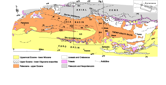
FIGURE 1
Structural map of the South-central Pyrenees indicating the location of the study area (boxed). Geological structures: AA: Añisclo Anticline; AtA: Atarés Anticline; BA: Boltaña Anticline; Co: Cotiella thrust; EC: Eaux-Chaudes thrust; Ga: Gavarnie thrust; GS: Guarga Syncline; In: Illón thrust; Ja: Jaca thrust; La: Larra thrust; Le: Leyre thrust; Lk: Lakora thrust; MA: Mediano Anticline; Or: Ordesa thrust; Ot: Oturia thrust, YA: Yebra de Basa Anticline. Towns: An: Ansó; Ar: Aragüés del Puerto; Ro: Roncal.
This area hosts the sole hydrocarbon producer in the South Pyrenean thrust belt, featuring the Serrablo gas field, which produced 1000MMNm3 and was later transformed into a gas storage facility (Díaz-Merino et al., 2005). This results in a unique wealth of commercial seismic profiles and deep wells which provide an excellent opportunity to investigate the subsurface stratigraphy and structure of the South Pyrenean basin. The dense network of seismic profiles, coupled with a well-known surface geology allow to propose a new definition of the basement thrust system and its relationships with the thrust-fold system in the Meso-Cenozoic cover, presented here by the mean of subsurface structure maps and four new structural balanced cross-sections. This work also highlights the influence of mechanical stratigraphy, which causes contrasting structures between competent carbonate rocks in the deep basin (pre-orogenic and early syn-orogenic) and the less competent units of the clastic infill of the foreland basin in the shallow subsurface. The area also features a great deal of tectonics-sedimentation relationships (e.g.Puigdefábregas, 1975; Mutti et al., 1988; Millán Garrido et al., 2000; Remacha et al., 2003; Fernández et al., 2012; Mochales et al., 2012a; Muñoz et al., 2013; Roigé et al., 2016, 2017) and low-temperature thermochronology data (Labaume et al., 2016a, b), which provide constrains of the timing of the key events in the thrust belt evolution.
Geological setting
The South Pyrenean basin
The Pyrenean collisional orogen results from the convergence of the Iberian and European plates from the Late Cretaceous (late Santonian) to the Early Miocene, following an episode of rifting and passive margin formation during mid-Cretaceous times (e.g.Roure et al., 1989; Muñoz, 1992; Teixell, 1998; Vergés et al., 2002; Mouthereau et al., 2014; Teixell et al., 2016, 2018 and references within). The Pyrenean belt comprises an Axial Zone of Paleozoic and Neoproterozoic basement uplifted by a system of south-vergent thrusts connected the so-called South Pyrenean Zone (Séguret, 1972), which is a fan of Meso-Cenozoic sedimentary cover thrust sheets detached above the Triassic evaporite layer. To the South, the South Pyrenean Zone is thrust over the Ebro foreland Basin by the South Pyrenean frontal thrust. The South Pyrenean Zone comprises a system of Upper Cretaceous to Oligocene flexural basins partitioned into several sub-basins by transverse structures. In the central Pyrenees (Fig. 1), the uppermost Cretaceous to Eocene fluvio-deltaic Tremp-Graus Basin passes westwards to the Jaca Basin with distal depositional systems (turbidites) through a zone of transverse folds and thrusts in the Aínsa area (see references below). In the late Eocene, the South Pyrenean basin became entirely terrestrial by tectonic closure of seaway connections and strong detrital sediment progradation mainly sourced from the uplifting orogen. During the lower Miocence, the flexural depocenter migrated southwards with the development of the South Pyrenean frontal thrust (Fig. 1).
Stratigraphy and structure of the study area
The study area corresponds to the eastern part of the Jaca Basin (Figs. 1; 2). It is about 45km-wide in the E-W direction along the basin axis and extends from the edge of the Axial Zone to the North (Sierras Interiores in Fig. 2) to the South Pyrenean frontal thrust in the South (Sierras Exteriores in Fig. 2).
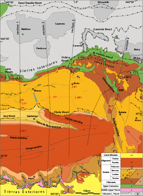
FIGURE 2.
Geological map of the eastern Jaca Basin showing the main stratigraphic units and structures and the location of the cross-sections of Figure 8 (modified after Labaume et al., 2016b) (see location in Fig. 1). Also indicated are the exploration wells used in this study (see Fig. 4 for the location of seismic profiles). BMF: Balupor-San Marzial normal Faults; CTS: Cotiella Thrust Sheet; PMTS: Peña Montañesa Thrust Sheet (Castillo Mayor klippe). Wells: AB1: Ayerbe de Broto 1; B1: Broto 1; Bo1: Boltaña 1; S1 to 9: Serrablo 1 to 9; SV1: San Vincente 1. Key to stratigraphic units (inset): 1: Paleozoic metasediments intruded by granitoid massifs (g) and overlain by a tegument of Permian-Lower Triassic red beds (dots); 2: Muschelkalk and Keuper facies (décollement layer); 3: platform carbonates and sandstones; 4: terrestrial red beds (Garumnian facies) in the Sierras Exteriores; 5: platform carbonates; 6: Hecho Group turbidites with carbonate breccia megabeds (MT, numbered as in Labaume et al., 1985); 7: Larrés marl; 8: Sabiñánigo sandstone; 9: Guara and Boltaña platform limestones; 10: Pamplona-Arguis marl; 11: Belsué-Atarés sandstone; 12: Campodarbe Group; 13: Uncastillo Formation
Stratigraphy of the eastern Jaca Basin
The stratigraphic organization of the Jaca Basin along the N-S transect, normal to the basin axis, is summarized in the chronostratigraphic diagram of Figure 3. The basement comprises Paleozoic metasediments intruded by tardi-Variscan granitoids and covered locally by a tegument of Permian-Lower Triassic terrestrial detrital red beds. The Middle-Upper Triassic shales, carbonates and evaporites (Muschelkalk and Keuper facies) are absent on this sector of the Axial Zone but underlie the whole Jaca Basin (drilled in the Broto, Serrablo 1 and San Vicente wells; B1, S1 and SV1, respectively, in Fig. 2) and crop out in the Sierras Exteriores. The post-Triassic cover begins with transgressive Upper Cretaceous platform carbonates, beginning in the Cenomanian to the North to the Santonian to the South. From the onset of the Pyrenean convergence in the late Santonian, the facies organization is typical of a flexural basin migrating toward the foreland (to the South) (Puigdefábregas and Souquet, 1986; Teixell, 1996).
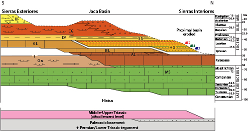
FIGURE 3.
Chronostratigraphic diagram for the eastern Jaca Basin (time scale after Cohen et al., 2013). Lithostratigraphic units: AL: Alveolina Limestone (platform); BL: Boltaña Limestone (platform); CG: Campodarbe Group (fluvial-alluvial); DF: Deltaic Facies (Larrés and Pamplona-Arguis marls and Belsué-Atarés sandstone); Ga: Garumnian terrestrial red beds; GL: Guara Limestone (platform); HG: Hecho Group turbidites (with carbonate megabreccia beds numbered as in Labaume et al., 1985); MS: Marboré Sandstone (platform); SS: Sabiñánigo Sandstone (delta); UF: Uncastillo Formation (alluvial-fluvial).
The Campanian-Maastrichtian of the northern Jaca Basin corresponds to carbonate-dominated mixed platform deposits thickening northward, the Marboré sandstone. They are followed by Paleocene platform carbonates which pass laterally to the South and East to terrestrial deposits (Garumnian facies red beds and lacustrine limestone). To the North, the Paleocene is followed by the lower Ypresian Alveolina limestone and the mid to upper Ypresian Millaris, Metils and Yeba marly limestone formations (Van Lunsen, 1970; Ríos Aragüés et al., 1982a). These facies are onlapped by the Ypresian to lower Bartonian Hecho Group turbidites, about 4000m-thick (e.g.Mutti et al., 1988; Remacha et al., 2003; Oms et al., 2003), which mark a stage of rapidly subsiding, underfilled marine basin evolution. The turbidites are coeval to platform carbonates along the southern basin border, the Boltaña and Guara limestones, which retrograded toward the foreland while the onlap of the turbidites migrated in the same direction (Labaume et al., 1985; Puigdefábregas and Souquet, 1986; Barnolas and Teixell, 1994; Mochales et al., 2012a). The successive carbonate platform units end by drowning unconformities and correlative shelf-edge truncations (Barnolas and Teixell, 1994), and are frequently covered by slope marls before turbidite onlap (e.g. the Burgui marl that forms the source rock for the Serrablo gas field; Cámara and Klimowitz, 1985; Díaz-Merino et al., 2005).
The siliciclastic turbidites of the Hecho Group were mainly fed axially by a fluvio-deltaic system located in the East (Tremp-Graus Basin) but feature north-sourced supply in the uppermost part (Remacha et al., 1987, 1998; Roigé et al., 2016) and contain several intercalated carbonate breccia and calcarenite megabeds derived from the southern platform (Labaume et al., 1983, 1985, 1987; Barnolas and Teixell, 1994). Three of these megabeds crop out in the study area (MT3, 4 and 5 in Fig. 2) and several younger ones were drilled and produced gas in the wells of the Serrablo field (wells S1, S4 and S9 in Fig. 2; Díaz-Merino et al., 2005). The Hecho turbidites and southern platform carbonates are followed by west-prograding deltaic systems (from bottom to top, the Larrés marl, Sabiñánigo sandstone, Arguis-Pamplona marl and Belsué-Atarés sandstone, over 2000m-thick in the central part of the basin) which mark the transition to the overfilled stage of basin evolution during the Bartonian to early Priabonian.
The overfilled stage corresponds to the deposition of the thick (up to 3500m) Priabonian to earliest Miocene Campodarbe Group comprising westward flowing fluvial deposits bordered to the North by north-sourced alluvial fans (Puigdefábregas, 1975; Montes Santiago, 1992; Roigé et al., 2016, 2017; see Roigé, 2018, for recent age attribution). The younger deposits of the Chattian-lower Miocene Uncastillo Formation (Fm.) are dominating the exposure of the Ebro Basin, with alluvial fan systems developed along the emerging South Pyrenean frontal thrust (Puigdefábregas, 1975; Hirst and Nichols, 1986; Millán Garrido et al., 2000).
Structure of the eastern Jaca Basin
Surface exposure combined with well data and seismic profile interpretation allow delineating the structure of the deep Jaca Basin and the underlying basement with a reasonable degree of confidence.
The basement structure of the study area comprises a system of imbricated south-vergent thrusts, with the Eaux-Chaudes and Gavarnie thrusts cropping out in the northern and southern parts of the Axial Zone, respectively (Fig. 2) and other thrusts in the subsurface of the Jaca Basin which progressively increase the structural elevation of the basement from the basin axis to the Axial Zone (Cámara and Klimowitz, 1985; Mutti et al., 1988; Millán Garrido et al., 2006; Labaume et al., 2016b). The Guarga thrust forms the toe of the basement thrust system below the axis of the basin. Above the latter, various interpretations of the subsurface thrust system have been proposed in the literature (see review in Labaume et al., 2016b). Recently, Labaume et al. (2016b) defined three main subsurface thrusts on the Oturia section (corresponding to section 2 in Figure 2) from seismic reflection profile interpretation and balanced cross-section construction, from South to North the Guarga, Fiscal and Broto thrusts.
The structure of the Meso-Cenozoic sedimentary cover is decoupled from the basement structure by the intervening décollement layer in the Middle-Upper Triassic Muschelkalk and Keuper facies, and features several imbricate thrust and fold systems, described below from the North to South (Fig. 2):
-
i) The Peña Montañesa thrust, which mainly crops out in the north-eastern Aínsa Basin, carries the Upper Cretaceous-Paleocene carbonates of the Castillo Mayor klippe thrust over the Hecho turbidites. It links northwards with the Cotiella thrust, which carries a thick Upper Cretaceous succession. The Cotiella and Peña Montañesa thrusts are the oldest in the vicinity of the study area as shown by unconformable deposits of uppermost Cretaceous age on the former and Ypresian age on the latter, as described in the Aínsa area (Séguret, 1972; Mutti et al., 1988; Muñoz et al., 2013; López-Mir et al., 2014).
ii) The Larra thrust system corresponds to small thrusts involving the Upper Cretaceous-Paleocene carbonates of the Sierras Interiores, detached on a décollement located in the lower part of the Campanian-Maastrichtian Marboré sandstone. To the South, the Larra thrusts propagate across the whole lower-middle Eocene turbidite succession, where the carbonate megabeds form key-beds revealing tectonic duplications (Labaume et al., 1985; Teixell and García-Sansegundo, 1995; Teixell, 1996), proving they were active at least up to the end Lutetian-early Bartonian.
iii) The Ordesa thrust, in the footwall of the Larra thrusts that crop out in the upper part of the Monte Perdido massif, duplicates most of the Upper Cretaceous-Paleocene carbonate succession with a décollement located in the lowermost part of the Upper Cretaceous limestones (Séguret, 1972; Ríos Aragüés et al., 1990b). Eastward, the Añisclo and Boltaña anticlines correspond to hanging wall folding of the Ordesa thrust sheet. They feature a pronounced map curvature toward the SE, where the décollement passes into the Triassic (Soler-Sampere and Puigdefábregas-Tomás, 1970; Muñoz et al., 2013) and they separate the Jaca and Aínsa basins. The Ordesa and Larra thrust systems collectively correspond to the Monte Perdido unit defined by Séguret (1972), and were considered equivalent to the whole Larra thrust system defined as a single system in the western Axial Zone by Teixell (1990). The Ordesa thrust is dated to the Lutetian-Bartonian from growth strata on the limbs of the Añisclo and Boltaña anticline (Puigdefábregas, 1975; Mochales et al., 2012a; Fernández et al., 2012; Muñoz et al., 2013). Paleomagnetic studies argue for an up to ~50° clockwise rotation of the Boltaña anticline around a vertical axis that may have started in the Ypresian (Mochales et al., 2012b) but mainly spanned the Lutetian to Priabonian times (Mochales et al., 2012b, 2016; Muñoz et al., 2013), i.e. partly post-folding.
iv) The Oturia thrust is a north-dipping thrust fault that emerges in the southern part of the outcrop area of the Hecho Group turbidites and brings these over the Bartonian-Priabonian deltaic and fluvial-alluvial deposits. The Oturia thrust dies out to the East into folding of the turbidites when approaching the transverse Boltaña anticline. In the northern part of their outcrop area, the turbidites are affected by chevron folding with regional axial plane cleavage (Ten Haaf et al., 1971; Séguret, 1972; Izquierdo-Llavall et al., 2013) which represents the frontal deformation of the Larra and Ordesa thrusts and hanging wall deformation of the Oturia thrust. Growth strata in the reverse limb in the footwall of the Oturia thrust suggests that the latter propagated through an anticline-syncline pair during the Priabonian to earliest Rupelian (Labaume et al., 2016b).
v) The Jaca thrust is another imbricate thrust that emerges in the Larrés marls in the western part of the study area and cores the Yebra de Basa anticline which also disappears eastward when approaching the Boltaña anticline. Growth strata on the limbs of the Yebra de Basa anticline indicate a Priabonian to Rupelian age of folding (Puigdefábregas, 1975; Labaume et al., 2016b). The Oturia and Jaca thrusts were thus active coevally but distribution of growth strata suggests that deformation begun earlier for the Oturia thrusting and terminated later for the Yebra folding (Labaume et al., 2016b).
vi) The South Pyrenean frontal thrust system emerges in the complex structure of the Sierras Exteriores (Puigdefábregas, 1975; Millán Garrido et al., 2000; Millán Garrido, 2006). The leading edge of the thrust system is buried under the upper Oligocene to Miocene Uncastillo Fm. which is cut in turn by small out-of-sequence thrusts. The outcropping structures of the External Sierras comprise an early generation of N-S trending folds detached on the Triassic that form a continuous trend of folds from the Mediano and Boltaña anticlines westwards (Figs. 1; 2) and a superimposed system of south-vergent thrusts corresponding to the emergence of the main South Pyrenean mountain front. Growth strata indicate: i) that the N-S trending folds started in Lutetian times in the East and propagated westward until the Priabonian, growing largely in submarine environments while affected by clockwise rotation and ii) an Oligocene-early Miocene age for the frontal thrust system, recorded by alluvial fans (Puigdefábregas, 1975; Poblet and Hardy, 1995; Hogan and Burbank, 1996; Millán Garrido et al., 2000; Pueyo et al., 2002; Millán Garrido, 2006; Oliva-Urcia et al., 2015; Rodríguez-Pintó et al., 2016).
Between the Yebra de Basa anticline and the Sierras Exteriores, the large Guarga syncline has a simple structure, although its hinge zone shows in detail different overlapping hinge segments and is affected by hectometer-scale folds and south-vergent minor thrusts. The Atarés anticline, a major anticline in the central Jaca basin, dies out eastward in the northern limb of the syncline in the western part of the study area (Fig. 2).
The fold and thrust structures in the Meso-Cenozoic cover are well dated by growth strata and unconformities. By contrast, absolute dating of the basement thrusts is very scarce and their correlation to cover structures is made difficult by the occurrence of the general basal décollement level of the cover succession which separates the basement from the cover thrusts.
At the western termination of the Axial Zone, the Larra thrust is connected northward to the Lakora basement thrust which represents the southern thrust front of the North Pyrenean Zone (Fig. 1) (Labaume et al., 1985; Teixell, 1990, 1996; Teixell et al., 2016, 2018) and is connected eastward to the Eaux-Chaudes thrust in the northern Axial Zone (Figs. 1; 2). Radiometric absolute dating around 50Ma were obtained in shear zones in the Néouvielle granite belonging to the Eaux-Chaudes thrust system (Wayne and McCaig, 1998; Jolivet et al. 2007). Hence, the Lakora-Eaux-Chaudes-Larra thrust system was probably active through a long period spanning the Ypresian to early Bartonian times during the early Pyrenean collision (Teixell et al., 2016, 2018). To the East, the Late Cretaceous Cotiella thrust and Ypresian Peña Montañesa thrust were also related to this early deformation (Teixell et al., 2018).
The connection of the Gavarnie basement thrust with the basin structures, and hence its age, have been debated in the literature. One interpretation connects the Gavarnie thrust to the Lutetian-Bartonian Ordesa-Boltaña thrust-fold system through the Triassic décollement (Fernández et al., 2012; Muñoz et al., 2013). Other authors group the Ordesa-Boltaña structure together with the Larra thrusts with the same connection to the Lakora-Eaux-Chaudes basement thrusts (Teixell, 1990, 1996; Jolivet et al., 2007; Labaume et al., 2016b). In turn, these authors link the Gavarnie thrust to younger structures in the Jaca Basin, in particular the Priabonian-Rupelian Oturia and Jaca thrusts. Geometric arguments for the latter interpretation are developed below in this paper. We note that this attribution is supported by Ar/Ar dating that assigns a maximum Priabonian age to the Gavarnie thrust fault zone (Rahl et al., 2011; Abd Elmola et al., 2018) and by the Rupelian exhumation age determined by ZrHe and apatite fission track thermochronology in the Gavarnie thrust hanging wall (Jolivet et al., 2007; Bosch et al., 2016).
By contrast, the unequivocal connection of the Guarga thrust to the South Pyrenean frontal thrust indicates its Chattian-earliest Miocene age (Teixell, 1996). Based on seismic reflection profile interpretation and balanced cross-section construction, Labaume et al. (2016b) related the newly-defined Broto and Fiscal thrusts to the (Priabonian)-Rupelian and Chattian-(early Miocene), respectively.
Surface and subsurface data used in this study
The surface geology used in this study is reported in published geological maps (Puigdefábregas, 1975; Gil Peña et al., 2011; Ríos Aragüés et al., 1982a, b, 1990a, b; Montes Santiago, 1991; Samsó Escolà et al., 1991; Millán Garrido, 2006) that we complemented by own field observations (Fig. 2).
The present study is mainly based on the inspection of 81 industrial seismic reflection profiles covering most of the study area (Fig. 4) and available on the Instituto Geológico y Minero de España website (http://www.igme.es). The profiles were acquired during the 70-80’s and the public versions are mostly not migrated, except for the 8 migrated profiles of the JA87 and JA88 series. The quality of seismic images is very variable, with often poor quality in the deformed northern area and better imaging to the South, in the weakly deformed Guarga syncline. However, propagation of the most robust observations through profile correlation allowed a relatively good definition of subsurface structures at the scale of the study area.
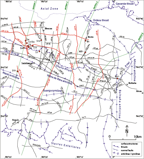
FIGURE 4.
Sketch map of the eastern Jaca Basin showing the location of seismic profiles and wells used in this work. The traces of the seismic profiles interpreted in Figure 5 are indicated in red. In green are the traces of the geologic cross-sections of Figure 8. The trace of surface major structural elements is shown in blue (cf. map in Fig. 2). B-SM f: Balupor-San Marzial normal faults. Wells: AB1: Ayerbe de Broto 1; B1: Broto 1; Bo1: Boltaña 1; S1 to 13: Serrablo1 to 13; SV1: San Vincente 1.
The stratigraphic interpretation of the seismic profiles was made from 12 wells, most of them located in the Serrablo gas field, in the western part of the study area (Fig. 4) (Lanaja et al., 1987; Díaz-Merino et al., 2005). Three wells crossed the whole detached sedimentary succession and reached the Triassic décollement (SV1 well), the Lower Triassic sandstone tegument (B1 well) or the Paleozoic basement (S1 well). Key reflections on the seismic images tied to well logs were used for depth conversion of the seismic profiles and cross-section construction.
Subsurface structures
The subsurface structures of the eastern Jaca Basin are illustrated in Figure 5 by a selection of interpreted seismic profiles representative of the cross-sections and major structures discussed in this work. A synthesis of surface and subsurface structures is presented with a depth contour map of the top of the basement in the subsurface (Fig. 6) and a map locating the major cover structures (Fig. 7). Our structural interpretation in profile is summarized in the four balanced cross-sections shown in Figure 8.
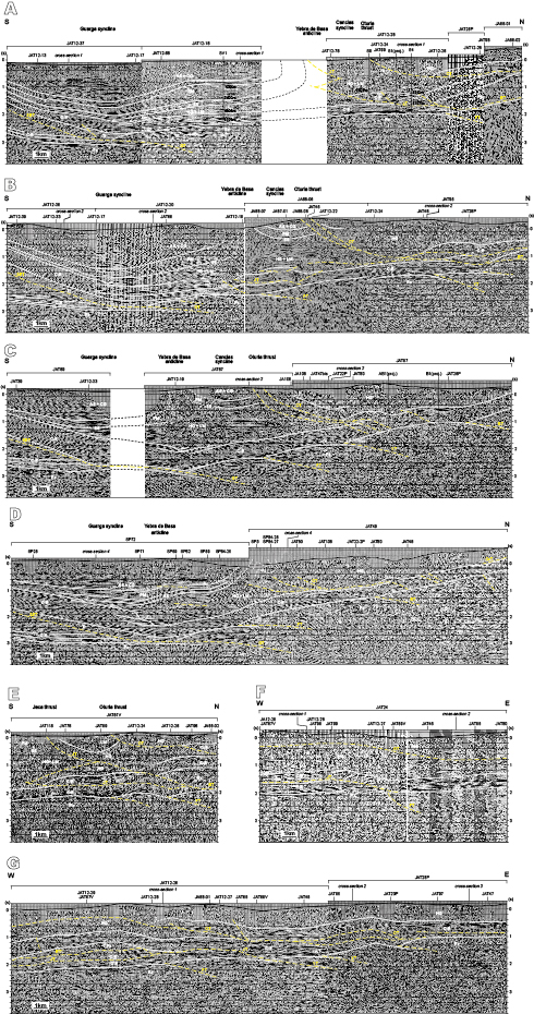
FIGURE 5.
Interpreted representative seismic profiles of the eastern Jaca Basin (profiles downloaded from the IGME website: www.igme.es). Lithostratigraphic units (white): AS+CG: (Belsué-) Atarés Sandstone and Campodarbe Group; C-E: Upper Cretaceous to middle Eocene carbonate platforms; HG: Hecho Group turbidites; LM: Larrés Marl; PM: Pamplona-Arguis Marl; Pz: Paleozoic (including the Permian-Lower Triassic tegument); SS: Sabiñánigo Sandstone; Tr: Middle-Upper Triassic. Thrusts (yellow): BT: Broto Thrust; BT*: Break-back thrusting of the Paleozoic of the Broto Thrust hanging wall (profile G); FT: Fiscal Thrust; GT: Guara Thrust; OT: Oturia Thrust; OrT: Ordesa Thrust (profile D); SET: Sierras Exteriores Thrust; ST: Serrablo Thrust; YT: Yésero Thrust. Wells (located in Fig. 4): AB1: Ayerbe de Broto 1; B1: Broto 1; S1: Serrablo 1; S4: Serrablo 4; S9: Serrablo9; SV1: San Vincente 1. For wells S4, S9 and SV1 located on the seismic lines, depth in meters of key stratigraphic horizons and thrust are shown (other wells are projected laterally from a few hundreds of meters to a few km). The profiles are located by red lines in Figure 4.
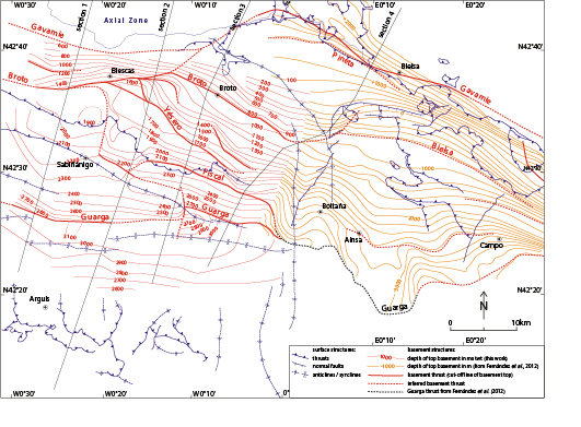
FIGURE 6.
Structural contour map for the top of basement in the eastern Jaca and northern Aínsa basins, constructed after data from wells and seismic profiles. Red: contours for the Jaca Basin (this study; depth in milliseconds two-way travel time); orange: contours for the Aínsa Basin (after Fernández et al., 2012; elevation in meters relative to sea level). The main basement thrusts deduced in this study are indicated with red bold lines corresponding to the cut-off lines of the basement top. The trace of surface major structural elements is in blue (cf. map in Fig. 2) and the traces of the 4 geologic cross-sections of Figure 9 are shown. B-SM f: Balupor-San Marzial normal faults.
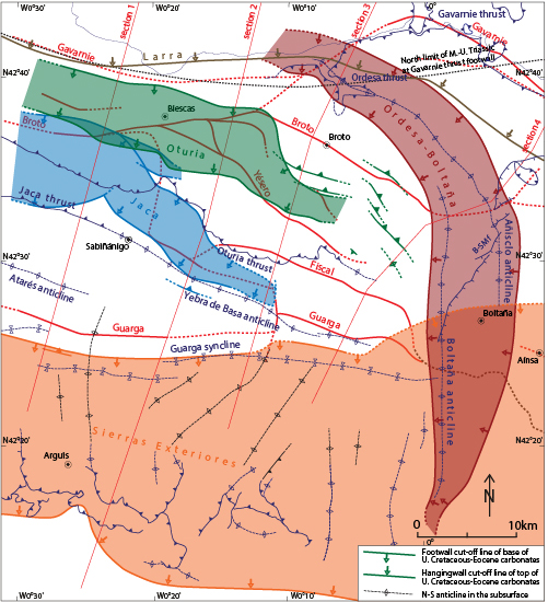
FIGURE 7.
Structural map showing the cutoff lines of the main sedimentary cover thrusts of the eastern Jaca Basin, derived from seismic profile interpretation and cross-section construction. For each thrust are shown the cut-off lines at the base of the footwall ramp and at the top of the hanging wall ramp across the Upper Cretaceous to middle Eocene carbonates (hanging wall ramp only for the Larra thrust), the colored domain corresponding to the overthrust area with repetition of the carbonate unit. In black are indicated the axes of the buried N-S trending décollement anticlines in the larger Guarga syncline. The trace of surface major structural elements is in blue (cf. map in Fig. 2) and the traces of the 4 geologic cross-sections of Figure 8 are shown. B-SM f: Balupor-San Marzial normal faults.
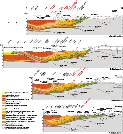
FIGURE 8.
Serial cross-sections of the eastern Jaca (1 to 3) and the Jaca and NW Aínsa basins (4), integrating surface and subsurface data. See Figures 2, 4, 6 and 7 for location. Seismic profiles and wells used for section construction are located in Figure 4. Section 2 modified after Labaume et al. (2016a). Carbonate megabreccia beds numbered as in Labaume et al. (1985).
Basement structures
In the seismic profiles, the lower part of the cover succession is generally marked by high-amplitude reflections corresponding to the Upper Cretaceous-Eocene carbonates (see below) overlying the usually transparent or chaotic facies forming the lower part of profiles and corresponding to the basement (Fig. 5). The seismic profiles provide no evidence of thick accumulation of the Keuper and Muschelkalk facies forming the décollement layer and their thickness is limited to tens of meters (mainly of carbonates) where drilled (Broto 1 and Serrablo 1 wells, Fig. 2). So, in spite of the uncertainty due to the non-identification of the décollement layer, we used the base of the high-amplitude reflection interval as a proxy of the basement top. Locally, a set of underlying high-amplitude reflections sub-parallel to the basement top may represent the Permian-Lower Triassic (Buntsandstein) tegument (included in the basement in the interpreted seismic profiles of Fig. 5 and the basement top map of Fig. 6).
In Figure 6, our map of the basement top is contoured in milliseconds (two-way travel time). To the East, the map is extended by the reproduction of part of a map of the Gavarnie thrust surface under the Aínsa Basin (in meters relative to sea level) published by Fernández et al. (2012). We selected the part of the Fernández et al.’s (2012) map where the Gavarnie thrust corresponds to the décollement surface of the sedimentary cover succession and thus can be used as a proxy of the basement top. Although the 100ms spacing of the contour lines (corresponding to about 200–250m) tends to smooth the topography, the map of Figure 6 correctly traduces the major topographic irregularities observed in the seismic profiles and is thus considered sufficient to map the major, km-scale basement structures. Below, we first describe the basement structure in our study area, West of the Boltaña anticline, then that to the East of the anticline deduced from the Fernández et al.’s (2012) map.
Basement structure West of the Boltaña anticline
The deepest depression of the basement top (around 3000ms twt/6000m bsl) corresponds to a narrow domain below and sub-parallel to the Guarga syncline hinge observed at the surface. This domain tends to shallow slightly eastward when approaching the Boltaña anticline. The northern border of this basement low corresponds to the hanging wall cutoff line of the basement top along the Guarga thrust (Millán Garrido, 2006). To the South, the gentle northward dip of the basement top corresponds to the foreland flexure. To the North, the usually steeper southward dip is related to the stacking of basement thrusts under the northern Jaca Basin, with various irregularities in dip and trend that we interpret as due to the occurrence of several thrusts as well as oblique structures (faults or lateral ramps). In particular, the thrusts are identified from the slope breaks that we interpret as the hanging wall cutoff lines of the basement top, i.e. separating the relatively steep forelimb of the hanging wall culmination and the flat (or less inclined) top of the culmination of an underlying thrust. In some cases, we mapped the thrusts beyond the termination of the slope break visible on the map when a less pronounced slope break remains visible on the seismic lines. This mapping allows to refine and generalize the interpretation of the basement thrust system recently defined by Labaume et al. (2016b) for the Oturia cross-section (section 2, Fig. 6).
In the central part of the studied area (corresponding to seismic profiles B and C in Figure 5 and sections 2 and 3 in Fig. 8), the main slope breaks define four imbricated thrusts, from South to North the Guarga, Fiscal, Yésero and Broto thrusts. More to the North, the Gavarnie thrust is defined West of the Gavarnie window (the westernmost outcrop of the thrust) by cross-section construction, i.e. deducing the shape of the hanging wall culmination and the location of the related cutoff line of the basement top from the hanging wall structure outcropping at the southern edge of the Axial Zone. The Guarga, Fiscal, Broto and Gavarnie thrusts correspond to the thrust system defined by Labaume et al. (2016b) along the Oturia transect (section 2 in Fig. 8), while the Yésero thrust is here newly defined.
In this central domain, the subsurface thrusts show a general WNW-ESE (N110-120°E) trend. To the West, the Broto thrust passes to an ENE-WSW (N075°E) trend between sections 2 and 1, then resumes the WNW-ESE trend more to the West, while the Yésero thrust joins the Broto thrust in its ENE-WSW trending segment. The Fiscal thrust terminates westward, also possibly joining the Broto thrust through a poorly-defined N-S trending segment under the Gállego valley. The seismic profiles show that the Yésero and Fiscal thrust do not branch to the Broto thrust but pass to an underlying thrust (Fig. 5A, E; section 1 in Fig. 8). Hence, only the Guarga and Broto thrusts are defined from the top basement map West of the río Gállego, the Guarga thrust featuring an up to 18km-wide, low relief culmination with an almost flat top between 2000 and 2200ms (4000–4500m bsl) (Fig. 5A; section 1 in Fig. 8). This trend of reducing the structural relief of the top basement and the number of thrusts South of the Broto thrust is consistent with what is observed West of the study area in the central Jaca Basin (see below). Another particular feature of this western domain derived from our interpretation of the seismic lines is that, in contrast to all other basement thrusts of the study area that branch upward/southward into the Triassic décollement layer, the toe of the Paleozoic in the Broto thrust hanging wall here climbs up the footwall ramp across the Upper Cretaceous-Eocene carbonates which links to the Jaca cover thrust (see below; Fig. 5A, E; section 1 in Fig. 8). The seismic lines also show that the Broto basement thrust propagated a few hundred meters across the Jaca thrust hanging wall in a break-back-sequence (Fig. 5A, E; section 1 in Fig. 8). This breaching interpretation differs from previous sections of this area depicting a classical branching of the basement thrusts into the Triassic décollement (e.g.Cámara and Klimowitz, 1985; Díaz-Merino et al., 2005; Gil Peña et al., 2011).
To the North, the Gavarnie thrust also features a NE-SW trending segment between the Gavarnie window and the Gállego valley, marked at the surface by the deviation of the basal contact of the sedimentary cover from its classical WNW-ESE trend in the East and West. Hence, the whole basement structure in the hanging wall of the Guarga thrust is affected by oblique, NE-SW trends between the Gavarnie window and Sabiñánigo, separating two domains with a markedly different organization of the thrust system, and offsetting the Gavarnie and Broto thrusts about 17km and 10km, respectively (Fig. 6). The coincidence of these local changes of trend with a reduction of the number of thrusts westward may suggest that a set of inherited structures (Permian-Mesozoic faults?) can have controlled this complex pattern.
To the East, our map allows following the Guarga and Broto thrusts up to the Boltaña anticline while the slope breaks defining the Fiscal and Yésero thrusts fade away East of section 3 (Fig. 6). However, less pronounced slope breaks visible in the seismic profiles suggest that the Fiscal thrust extends eastward and curves to the South-East to branch to the Guarga thrust. In this eastern area, the Guarga thrust is located more to the North than in the West. The available seismic data do not allow mapping precisely the structure of the Guarga thrust between the two sectors, but they suggest the existence of a lateral ramp just East of section 3. A slight high of the foreland basement is also mapped on the eastern side of this inferred lateral ramp.
Basement structure East of the Boltaña anticline
The extension of the basement structure east of the Boltaña anticline can be assessed from the map by Fernández et al. (2012) reproduced in Figure 6, complemented by our observations of the seismic profiles shown in Figure 4. Although the two maps were made independently and designed with different vertical scale units, they clearly show that the general WNW-ESE trend of the basement structure observed West of the Boltaña anticline continues eastwards below the Aínsa Basin. The Guarga thrust we define West of the Boltaña anticline connects well with the thrust trace defined by Fernández et al. (2012). At mid-slope between Aínsa and Bielsa, a 7km-wide sub-horizontal flat allows defining another basement thrust corresponding to the Bielsa thrust of previous authors (e.g.Martínez-Peña and Casas-Sainz, 2003; Casas et al., 2003; Jolivet et al., 2007), but with a more southern location. This thrust is likely connected to the Broto thrust through an oblique segment under the Añisclo anticline. Between Aínsa and Campo, a slope break suggests the presence of another basement thrust in a position equivalent to that of the Fiscal thrust, but the map does not provide evidence for a connection between both thrusts.
North of the Broto-Bielsa thrust, another WNW-ESE trending fault, the Pineta fault, can be defined West of Bielsa, under the Pineta valley. It can be followed up to the South of the Gavarnie window where tracking is lost due to the lack of data. South of the Pineta fault, a change of dip of the basement top is also constrained on section 4 (Fig. 8) by cross-section construction from surface geology under the Castillo Mayor klippe, suggesting the existence of another fault, here named the Escuaín fault (this fault is not shown in Fig. 6 because it does not appear in Fernández et al.’s (2012) map and its identification from a single cross-section construction does not allow determining its map trend and extension). The Pineta and Escuaín faults may be basement thrusts with the same style as the other ones described above or, alternatively, they may belong to the set of fractures and reverse faults with reduced offset which were described to intensely deform the Bielsa granite at the surface (Casas et al., 2003). Fernández et al.’s (2012) map also shows a narrow, N-S trending high of the top of basement below the Boltaña anticline. However, the interpretation of this structure remains dubious and it was alternatively envisaged as an accumulation of Keuper facies in the anticline core (Fernández et al., 2004). Finally, North of the subsurface map, the Gavarnie thrust is located from the outcrop of its basement hanging wall cutoffs in the Gavarnie and Larri windows and in the Pineta valley.
Sedimentary cover structures
Figure 7 shows the location of the thrust units in the sedimentary cover of the eastern Jaca Basin, identified by mapping the cutoff lines at the base of the footwall ramps and at the top of the hanging wall ramps across the Upper Cretaceous to Eocene carbonates. For each thrust, the colored domain corresponds to the interval between these two lines, except for the Larra thrust where only the hanging wall cutoff is shown (the footwall cutoff being eroded above the Axial Zone). Below, we describe successively the complex northern area and the simpler southern domain corresponding to the Guarga syncline.
Northern area
North of the Yebra de Basa anticline, the subsurface structure of the sedimentary cover is mainly defined in seismic profiles by a group of high-amplitude and relatively high-continuity reflections which form a 300–400ms (around 1000m) thick interval corresponding to the Upper Cretaceous-Eocene carbonates (labelled C-E on profiles in Figure 5). Above, the Hecho turbidite succession is essentially transparent in the northernmost part of the area where it is affected by chevron folding as seen at the surface. More to the South, discontinuous reflections are locally visible in the turbidites in the hanging wall of the Oturia thrust. The whole succession is often relatively well imaged below the Cancias syncline, while few reflections are visible under the Yebra de Basa anticline due to steep bedding dips (except in the eastern part of the study area where a gentler folding allows for better seismic images, cf. Fig. 5D).
In the Upper Cretaceous-Eocene carbonates, the thrust footwall ramps are well visible in several profiles (e.g. Fig. 5A, B, F, G) while the hanging wall ramps are most often not visible, likely due to perturbation of the seismic signal by fault-related hanging wall folds. In the overlying detrital formations, only the shallow part of the Oturia thrust is locally well imaged (e.g. Fig. 5B).
Combining seismic profile observation with surface geology allows describing four main cover thrusts North of the Yebra de Basa anticline, from North to South the Larra, Ordesa-Boltaña, Oturia and Jaca thrusts (Fig. 7).
The Larra thrust system
The hanging wall cutoff line of the Upper Cretaceous-Eocene carbonates crops out at the northern edge of the studied area (see map of the thrust sheets in Fig. 2) while the footwall cutoff line is not identified due to erosion above the Axial Zone. To the South, the shallower part of the Larra thrusts affects the Eocene turbidites producing duplications of the carbonate megabeds and chevron folding (Fig. 8). These structures are well exposed at the surface but not visible on the seismic profiles.
The Ordesa-Boltaña thrust
The Ordesa thrust outcrops around the western part of the Monte Perdido massif (from the Ordesa valley to the Gavarnie window) where mapping shows that it is connected to the North to a décollement located in the lowermost part of the Upper Cretaceous carbonates, in the hanging wall of the Gavarnie basement thrust (Séguret, 1972; Ríos Aragüés et al., 1990b). There is no evidence of a kinematic connection with the Gavarnie thrust in this area, if we discard the possibility of an undocumented fish-tail structure. At the western termination of the Monte Perdido massif (Ara river valley), mapping also evidences a lateral ramp of the sole thrust cutting westward up-section into the Marboré sandstone. The Upper Cretaceous-Eocene carbonate thrust sheet disappears West of the Ara valley due to erosion, but the lateral ramp suggests it may extend more to the West as one of the Larra thrusts defined in the central part of the Jaca Basin.
East of the Ordesa valley, the Ordesa thrust is in the subsurface and is expressed at the surface by its hanging wall Añisclo and Boltaña anticlines, and by folding of the Eocene turbidites West of the Boltaña anticline. In this eastern domain, the basal thrust cuts down-section eastward to join the Triassic décollement layer, as seen West of Bielsa (Séguret, 1972) (Fig. 2) and represented in cross-sections across the Añisclo and Boltaña anticlines (Fernández et al., 2012; Muñoz et al., 2013) (section 4 in Fig. 8). The coincidence of the northern termination of the Triassic décollement layer with the zone of curvature of the Añisclo and Boltaña anticlines (Fig. 7) suggests that the distribution of the décollement layer favored the clockwise rotation of the anticlines (Muñoz et al., 2013). The NE-SW to N-S trending Balupor-San Marzial normal fault system has been interpreted as resulting from stretching in the zone of curvature of anticlines (Muñoz et al., 2013).
The Oturia thrust
West of the Ara valley, the repetition of the Upper Cretaceous-Eocene carbonates is well visible in seismic profiles (Fig. 5A, B, E, G). The thrust trends WNW-ESE, parallel to the regional trend (Fig. 7). Displacement is relatively large, around 4–5km (sections 1 and 2 in Fig. 8), and the thrust zone often comprises several minor ramps enclosing duplex structures (Fig. 5B; section 2 in Fig. 8).
From the Ara valley eastwards, the thrust sheet is poorly imaged in seismic profiles and can hardly be defined with precision (Fig. 5C, D). However, it is observed that the thrust follows the Boltaña structural curvature toward the SE and splays into various thrust-fold structures with limited displacement (and decreasing eastwards), traducing the progressive tipping out of the Oturia thrust as it approaches the Boltaña anticline (sections 3 and 4 in Fig. 8).
The direct relationship between the deep thrust system in the Upper Cretaceous-Eocene carbonates with the surface Oturia thrust across the Hecho group turbidites is well imaged on several profiles with a low-angle ramp in the hanging wall and a steep ramp across a deformed, often overturned footwall (e.g. Fig. 5B). In the East, the curvature and the displacement decrease in the carbonates are correlated to the lateral dying out of the surface thrust reported above (section 4 in Fig. 8).
The Jaca thrust
West the of the Gállego valley, the repetition of the Upper Cretaceous-Eocene carbonates characteristic of the Serrablo gas field was drilled by the Serrablo 1 and Serrablo 4 wells and is well imaged in the seismic profiles (section 1 in Figs. 5A, E; 8) (Lanaja et al., 1987; Díaz-Merino et al., 2005). The carbonate thrust sheet covers a wide domain above the flat-top culmination of the Guarga basement thrust and has been translated southwards up to ca. 10km in the westernmost area (Fig. 5E). The hanging wall folds in the carbonate breccia megabeds of the Hecho group form the structural traps of the Serrablo gas field (Díaz-Merino et al., 2005). East of the Gállego valley, the carbonate thrust sheet splays in two parts, the northern, minor one rapidly disappearing eastward, and the southern one featuring a displacement reduced to around 5km, with a footwall ramp located more to the South than in the West (Fig. 5B; section 2 in Fig. 8).
There is no evidence that the thrust propagates southwards across the Guarga syncline. From the location of the carbonate thrust sheet under the Yebra de Basa anticline, we interpret the anticline as the surface expression of the thrust through a complex disharmonic structure between the Upper Cretaceous-Eocene carbonates and the weaker clastic formations, involving fish-tail thrusting to pass from low-angle thrusting to upright folding (Labaume et al., 2016b). West of Sabiñánigo, the Jaca thrust observed at outcrop (Figs. 2; 8) corresponds to a shallow branch of the fish-tail structure (Fig. 5E; section 1 in Fig. 8). More to the East where thrust displacement is lower, there is no evidence for an outcropping thrust (Fig. 5B; section 2 in Fig. 8). The equivalence between the low-angle thrust structure in the deep basin and the Jaca-Yebra de Basa upright thrust-fold structure in the near-surface is consistent with the structural relationships observed further West in the Jaca Basin (see below).
In the easternmost area, South of the Ara valley, the seismic profiles show that the repetition of the carbonates no longer exists (Fig. 5C, D; section 4 in Fig. 8). Unfortunately, the location of the available seismic profiles (Fig. 4) does not allow defining precisely where and how the thrust sheet disappears, i.e. if its displacement is progressively reduced between seismic lines JA88-05 (Fig. 5B; section 2 in Fig. 8) and JAT67 (Fig. 5C; locted East of section 3 in Fig. 8) or it terminates against a lateral ramp or tear fault. A thrust unit with limited displacement is tentatively represented in section 3 of Figure 8, implying a lateral ramp immediately to the East. Whatever the case, a particular problem is posed because the Yebra de Basa anticline extends eastwards beyond the eastern termination of the Jaca thrust in the Upper Cretaceous-Eocene carbonates. However, this easternmost part of the anticline is characterized by a rapid decrease of the fold amplitude, which passes to a smaller box-shaped anticline through a zone of curvature, lateral offset and eastward plunge of the hinge located just East of section 3 (section 4 in Figs. 7; 8). The seismic profiles also show that the fold amplitude decreases downward (Fig. 5D). We interpret these features as indicating that the disharmony between the thrust sheet in the Upper Cretaceous-Eocene carbonates and folding in the overlying clastics exists not only vertically but also laterally, allowing for extension of folding beyond the thrust termination. Moreover, this easternmost part of the Yebra de Basa anticline is located near the hinge zone of the Guarga syncline, which is here narrower than in the West. It is possible that the anticline here also obeys to contraction in the core of the syncline hinge zone, similarly to small folds and thrusts observed more to the West in a similar position (see below).
Southern area
The southern area corresponds to the large Guarga syncline, well imaged in the seismic profiles (Fig. 5A to D). The northern limb corresponds to tilting of the cover units above the frontal limb of the underlying hanging wall culmination of the Guarga basement thrust, while the southern limb corresponds to the hanging wall flat above the footwall ramp of the Sierras Exteriores thrust. The latter thrust is generally well visible in the seismic profiles, which image a usually thick Triassic in the hanging wall and the low northward dip of footwall beds (Fig. 5A to D). The footwall cutoff line of the base of the Upper Cretaceous-Eocene carbonates coincides with the syncline hinge, but its more northerly position in the Aínsa basin (Fernández et al., 2012; Muñoz et al., 2018) implies the existence of an oblique footwall ramp when approaching the Boltaña anticline (Fig. 7). Hence, the footwall ramp passes under the Guarga basement thrust as it curves northeastwards, and seismic profile interpretation by Fernández et al. (2012) and Muñoz et al. (2018) show that the leading edge of the Paleozoic in the hanging wall of the Guarga thrust climbs up the footwall ramp of the Sierras Exteriores thrust in the Aínsa Basin.
The seismic images illustrate the southward taper and facies migration of the syn-orogenic succession. The southward thinning of the Upper Cretaceous-Paleocene platform carbonate sequences is compensated by the increased thickness of the Eocene platforms, but individual formations cannot be resolved on the seismic profiles. However, in the hinge zone of the Guarga syncline, the upper carbonate units show north-facing steps interpreted as the shelf-edge truncations of the retrogressive platforms from which the Eocene carbonate breccia megabeds were sourced, then onlapped by turbidites (Barnolas and Teixell, 1994). Above the carbonates, the southward taper of the sedimentary succession related with the foreland flexure is well visible in the seismic images of the Eocene clastics, in particular in the lower part (under the Sabiñánigo sandstone), while the northward taper of the Priabonian-Rupelian strata on the southern limb of the Yebra de Basa anticline is too close to the surface to be depicted in the seismic profiles.
The seismic profiles also show the northward extension of the N-S trending décollement folds of the Sierras Exteriores (Fig. 7). The interpreted growth strata suggest that folding remained active during a large part of the Priabonian.
In the western part of the study area, the northern limb of the Guarga syncline is deformed by the eastern termination of the Atarés anticline (Fig. 2). The JAT12-16 seismic profile (Figs. 4; 5A) shows that the fold dies out downwards and does not affect the Upper Cretaceous-Eocene carbonates, similarly to the structure observed at the eastern termination of the Yebra anticline (Figs. 5D; section 4 in Fig. 8).
Discussion
Thrust displacements
In the process of balanced cross-section construction, displacement on the basement thrusts of the eastern Jaca Basin was estimated from the geometry of their hanging wall culminations derived from the interpretation of seismic profiles or/and the geometric constraints of thrust-related folding. As basement thrusts are rarely imaged in the seismic profiles, we applied the fault-bend folding model of Suppe (1983), where the hanging wall ramp to flat transitions (i.e. the top of basement hanging wall cutoffs) are located in the breaks of slope of the contoured basement top surfaces whenever possible (Fig. 6). Footwall cutoffs were located assuming a crestal-uplift stage for the fault-bend folds, an assumption that minimizes displacement for a given fold axial surface configuration and avoids the location of shallow decollement levels within the basement (which would result at inconsistent different elevations in view of the lateral amplitude variations of the hanging wall culminations). The model does not account for internal deformation within basement culminations, but we think it allows a reasonable first-order localization of the top of footwall ramps and hence an estimation of displacement on the thrust. This method was already applied with good balancing results in the western Jaca Basin in previous works (Teixell and García-Sansegundo, 1995; Teixell, 1996; Labaume et al., 2016b). In the rare cases where a flat top of culmination is not observed, displacement value was estimated to satisfy both balancing constraints on the corresponding cross-section and consistency with the other parallel cross-sections.
In the Meso-Cenozoic sedimentary cover, we have seen that the footwall ramps in the carbonates are generally well imaged in seismics and although the hanging wall ramps are rarely observed, the constraints of balanced cross-section construction usually allow to determine their location with relative confidence and hence to estimate a reliable thrust displacement.
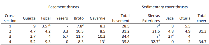
The summary of basement thrust displacements and cover thrust shortenings determined for the four cross-sections is presented in Table 1. This table excludes the Eaux-Chaudes basement thrust and related Larra cover thrust for which the total shortening cannot be determined due to erosion and also the Añisclo and Boltaña anticlines which we interpret as being related to the same basement thrust system (see below). In the case of cross-section 2, we obtain a good balance between 31 and 31.5km between the total displacement on the basement thrusts and total shortening in the cover. In the case of cross-section 4, the balance is also relatively correct around 35–35.5km (in view of the obliquity of some thrusts on this section) when using the Sierra de Guara cross-section by Millán Garrido (2006) showing 32.7km shortening on the Sierras Exteriores thrust. On the other hand, we are reluctant to use the Millán Garrido (2006) cross-section of the Sierras Exteriores extending our cross-section 1 to balance the latter, because the 25.2km shortening on the Sierras Exteriores thrust shown by Millán Garrido (2006) exceeds the shortening of 21.8km we obtain on this thrust on cross-section 2 located more to the East, in contradiction with the westward shortening decrease along the thrust front (Millán Garrido et al., 2000; Millán Garrido, 2006). The displacements estimated from the culmination geometry being reliable for the Guarga, Broto and Gavarnie basement thrusts in cross-section 1, we have chosen a little constrained 3.5km displacement for the Fiscal-Yésero basement thrust in order to obtain a total basement displacement slightly lower (around 3km) than in cross-section 2. In the absence of cross-section for the Sierras Exteriores thrust South of cross-section 3, we cannot precisely estimate the basement/cover balance for that section.
Thrust ages
As stated above, the thrust and fold structures in the sedimentary cover are generally well dated by the related growth strata, but their kinematic relationships with the basement thrusts is made difficult as they are decoupled from the latter by the Triassic décollement layer. However, the detailed 3D structural analysis presented here for the whole eastern Jaca Basin gives arguments for basement-cover kinematic relationships in accord with the timing of basement thrust activity in the Oturia section (section 2 in Fig. 8) recently reported by Labaume et al. (2016b). In this interpretation, the basement thrust sequence comprises a propagation of the Lakora-Eaux-Chaudes thrust system across the Jaca Basin during the Lutetian-Bartonian, a Priabonian-Rupelian age for the Gavarnie and Broto thrusts and a Chattian to early Burdigalian (around 20Ma) age for the Yésero, Fiscal and Guarga thrusts. The main features supporting this interpretation can be summarized as follows:
-
i) The Larra thrust system, rooted in the Lakora-Eaux Chaudes basement thrust, propagated across the whole Lutetian turbidite succession (Labaume et al., 1985; Teixell and García-Sansegundo, 1995; Teixell, 1996), attesting it was active at least up to the end Lutetian-early Bartonian.
ii) The connection of the Ordesa thrust to a décollement located in the lower part of the Upper Cretaceous carbonates in the hanging wall of the Gavarnie thrust at the western Monte Perdido massif (Séguret, 1972; Ríos Aragüés et al., 1990b) is in conflict with the interpretation of a kinematic connection of the Añisclo and Boltaña folding with the Gavarnie thrust proposed by other authors (Fernández et al., 2012; Muñoz et al., 2013). The similar Lutetian-Bartonian age of the Añisclo and Boltaña anticlines with the Larra thrusts, and the lateral ramp in the Río Ara valley suggesting that the Ordesa thrust décollement was located at a higher structural level in the Upper Cretaceous more to the West, suggest that the Larra and Ordesa-Boltaña thrust systems where both rooted in the same basement thrust system in the northern part of the Axial Zone active during the middle Eocene. Folding of the Larra thrust system by the Gavarnie thrust in the whole Jaca Basin (Labaume et al., 1985; Teixell and García-Sansegundo, 1995; Teixell, 1996) also shows that the latter thrust is younger.
iii) On cross-sections 1 and 2, the Gavarnie thrust is the only basement thrust where the Oturia thrust can be rooted, if we discard a hypothetical fish-tail structure which could link the latter to a younger basement thrust located more to the South, for which there is no argument. Displacement balancing constraints imply that part of the Gavarnie displacement was also transferred to the coeval Jaca-Yebra de Basa thrust-fold structure and that the late movements on the latter were related to the Broto thrust. This argues for an activity of this pair of basement thrusts during the Priabonian-Rupelian, probably mainly Priabonian to early Rupelian for Gavarnie and Rupelian for Broto. It follows from our kinematic interpretation that if the growth and main clockwise rotation of the Boltaña anticline should have been related to basement thrusting in the northern Axial Zone, the last stages of rotation during the Priabonian (Mochales et al., 2012b, 2016; Muñoz et al., 2013) were more probably related to the Gavarnie thrust. This is coherent with the fact that the eastward terminations of the Oturia and Jaca cover thrusts imply that the Gavarnie displacement was transferred to the Sierras Exteriores thrust East of the Boltaña anticline, contributing to a displacement on the Sierras Exteriores thrust larger in this area than in the Jaca basin (Muñoz et al., 2013, 2018; Mochales et al., 2016) and placing the Boltaña anticline in a situation of right-lateral transfer zone.
iv) The remaining of displacement on the basement thrusts, i.e. part of Broto followed by the Yésero, Fiscal and Guarga thrusts, was transferred to the Sierras Exteriores thrust. The growth of the N-S trending folds uplifted by the Sierras Exteriores thrust spanned the late Lutetian-Bartonian for the eastern ones and tends to be younger, up to the Priabonian for the western ones as reported above. However, this deformation may be interpreted as being related to the westward propagation of shortening ahead the Boltaña anticline during its clockwise rotation (Mochales et al., 2012b; Muñoz et al., 2013) and thus not necessarily related to N-S displacement transferred below the Guarga syncline from the basement thrusts in the North of the Jaca Basin. Hence, the onset of N-S shortening on the larger Sierras Exteriores thrust may have begun during the Rupelian in relation to the late activity of the Broto thrust, then relayed in piggy-back sequence up to the early Miocene by the Yésero, Fiscal and Guarga thrusts. Growth strata at the northern edge of the Ebro Basin suggest that thrusting may have been active until around 20Ma (end Aquitanian-early Burdigalian) (Millán Garrido et al., 2000; Arenas et al., 2001; Oliva-Urcia et al., 2015). However, the transition between the activity times of the various basement thrusts is difficult to determine with the present knowledge, and local overlaps are possible. The mid-Oligocene age traditionally attributed to the end of the Campodarbe sedimentation in the Jaca Basin suggested that the latter was interrupted by the uplift related to the onset of the Fiscal-Guarga thrusts (Labaume et al., 2016b). However, the new dating of the upper part of the Campodarbe Group (Bernués Fm.) around 22Ma (Roigé, 2018) shows that sedimentation remained active in the Jaca thrust-sheet-top basin up to the last period of thrusting on the South Pyrenean thrust front.
The uncertainty on the timing of the activity relay between the various basement thrusts precludes calculating precise displacement rates for each thrust. Assuming a Broto-Yésero relay at the end of the Rupelian, we have calculated, for each cross-section, the displacement rates for the Gavarnie-Broto and Yésero-Fiscal-Guarga groups of thrusts. We obtain values decreasing westward from 2.2mm/yr (section 4) to 1.7mm/yr (section 1) for the Gavarnie-Broto group and from 1.8 to 1.5mm/yr for the Yésero-Fiscal-Guarga group. This reflects a westward decrease of shortening rate for each group of thrusts as well as a decrease through time from the oldest to younger group on each cross-section. The former result accords well with the westward shortening decrease along the Jaca Basin, while the latter is consistent with the decrease of strain rate expected at the end of activity at a thrust-belt front.
We have noted that the Escuaín and Pineta faults in the northern part of cross-section 4 (Fig. 8) may be steep reverse faults rather than linked thrusts. They may be out-of-sequence faults at the origin of the late, early Miocene southward tilting of the Bielsa granite detected by apatite fission track analysis (Jolivet et al., 2007; Labaume et al., 2016a).
Lateral continuity of structures and displacement variations in the Jaca Basin
Teixell and García Sansegundo (1995) and Teixell (1996) showed that the three Gavarnie, Broto and Guarga basement thrusts exist on the Aragüés valley transect, 23km West of our section 1, and on the Ansó transect, 15km further West (Fig. 1), while the Yésero and Fiscal thrusts are absent. According to these works, the Gavarnie thrust has a displacement of 10km on the two sections, while the Broto thrust displacement is of 4 and 1km on the Aragüés and Ansó sections, respectively and that of the Guarga thrust of 14 and 10km. The same three thrusts are also shown by Labaume et al. (1985) in the Roncal section, 10km West of the Ansó section.
Considering that in the eastern Jaca Basin the Broto and Gavarnie thrust activity spans over the Priabonian-Rupelian and that of the Yésero, Fiscal and Guarga thrusts does it from the Chattian to lower Burdigalian, the fact that almost all the displacement is concentrated on the two Gavarnie and Guarga thrusts in the West argues that westward of the area studied here most of the Broto displacement was transferred to the Gavarnie thrust, while that of the Yésero and Fiscal thrusts was transferred to the Guarga thrust, together within a frame of general displacement reduction.
The main cover structures described in this paper also extend at least up to the Roncal valley. The Oturia thrust is mapped until the vicinity of Roncal where it dies out into an anticline, while the hanging wall culmination of the Jaca thrust exposes the Upper Cretaceous-Eocene carbonates in the Foz de Binies-Sierra de Illón anticline, and the thrust emerges at the front of this fold (Ten Haaf et al., 1971; Labaume et al., 1985; Teixell and García-Sansegundo, 1995; Teixell, 1996) (Fig. 1). This relationship in the West between the Jaca thrust and the Foz de Binies-Sierra de Illón anticline supports our interpretation of the relationship between the deep thrust duplicating the Upper Cretaceous-Eocene carbonates and the shallow Jaca thrust-Yebra de Basa anticline through a complex zone of disharmony. The same relationship exists between the Sierra de Leyre thrust in the carbonates and the Atarés anticline in the central Jaca Basin (Fig. 1). We have seen above that at its eastern termination, the Atarés anticline extends more to the East than the underlying thrust in the carbonates (section 1 in Fig. 8), similarly to what we describe for the Yebra de Basa anticline termination.
Conclusion
The interpretation of a relatively dense set of seismic reflection profiles tied by deep exploration wells allows a new interpretation of the basement and sedimentary cover structure of the eastern Jaca Basin. Structural contour mapping and balanced cross-section construction illustrate that the Paleozoic basement is characterized by a complex structural pattern with several Alpine thrusts in the basement between the Gavarnie thrust at the southern edge of the Axial Zone and the Guarga thrust at the leading edge of the basement thrust system: from South to North, the Fiscal, Yésero and Broto thrusts. The five basement thrusts are present in the central part of the study area while some of them die out or merge sideways, eastwards and westwards. In the Biescas area, the westward branching and displacement reduction of the Yésero and Fiscal thrusts is associated with WSW-ENE trending segments of the Broto and Gavarnie thrusts, suggesting the influence of local pre-existing structures, possibly a set of Mesozoic faults.
Two major thrusts are defined in the subsurface within the Meso-Cenozoic sedimentary cover, involving repetitions of the Upper Cretaceous-Eocene carbonates of the deep Jaca Basin: the Oturia and Jaca thrusts. The former is directly linked to the emerging Oturia thrust well known at the surface while the latter, drilled in the Serrablo gas field, is connected to the emerging Jaca thrust and Yebra de Basa anticline through a zone of disharmonic deformation. Both thrust-fold systems die out and curve to the SE eastward when approaching the N-S trending carbonate ridge of the Boltaña anticline overlying the Ordesa-Boltaña thrust. Décollement in the Middle-Upper Triassic Muschelkalk and Keuper facies, widely recognized in the Pyrenees, separates the basement and cover thrust systems.
The only exception found to this structural pattern is the local breaching of the basement at the hanging wall of the Broto thrust above the Upper Cretaceous-Eocene carbonates in the western part of the study area.
The 3D reconstruction here presented supports the kinematic relationships proposed in a cross-section by Labaume et al. (2016b), with a connection of the Oturia and Jaca thrusts to the Gavarnie and Broto basement thrusts, dating those to the Priabonian-Rupelian. The Sierras Exteriores thrust, which onset was probably related to the Broto thrust during the Rupelian, was mainly associated with the Yésero, Broto and Guara basement thrusts during the Chattian and early Miocene. Both the displacement magnitudes and rates decrease westward along these two groups of basement thrusts; displacement rates also decrease with time.
This study highlights the changing structural styles that characterize the different mechanical-stratigraphic units in a basin profile. Specifically, the mechanical contrast between the competent carbonate units of the deep basin and the overlying, weaker detrital basin infill is expressed by relative low-angle thrusts in the former, which often ride on top of themselves with flats atop of the carbonates, and detached chevron fold trains and upright thrusts and tight folds in the latter (Fig. 8). It was also found from the examples of the Yebra de Basa and Atarés anticlines that disharmony allowed the anticlines in the detrital formations to propagate beyond the lateral termination of the underlying thrust-sheets in the carbonates. This would render the projection of the structures observed at the surface extremely difficult in the absence of seismic profiles. This study also illustrates the complex structural pattern that results from the lateral changes of thrust trends and displacement magnitudes in the South Pyrenean basin.
ACKNOWLEDGMENTS
We thank the thorough reviews by J.A. Muñoz, J.I. Soto and J.M. Casas which helped to improve this manuscript. A.T. work was funded by Project CGL2014-54180 of the MINECO (Spain).
Acknowledgments
We thank the thorough reviews by J.A. Muñoz, J.I. Soto and J.M. Casas which helped to improve this manuscript. A.T. work was funded by Project CGL2014-54180 of the MINECO (Spain).
Referencias
Abd Elmola, A., Buatier, M., Monié, P., Labaume, P., Trap, P., Charpentier, D., 2018. 40Ar/39Ar muscovite dating of thrust activity: a case study from the Axial Zone of the Pyrenees. Tectonophysics, 745, 412-429.
Arenas, C., Millán, H., Pardo, G., Pocoví, A., 2001. Ebro basin continental sedimentation associated with late compressional Pyrenean tectonics (northeastern Iberia): Controls on basin margin fans and fluvial systems. Basin Research, 13(1), 65-89.
Barnolas, A., Teixell, A., 1994. Platform sedimentation and collapse in a carbonate-dominated margin of a foreland basin (Jaca basin, Eocene, southern Pyrenees). Geology, 22(12), 1107-1110.
Bosch, G., Teixell, A., Jolivet, M., Labaume, P., Stockli, D., Domènech, M., Monié, P., 2016. Timing of Eocene-Miocene thrust activity in the Western Axial Zone and Chaînons Béarnais (west-central Pyrenees) revealed by multi-method thermochronology. Comptes Rendus Geoscience, 348(3-4), 246-256. DOI: 10.1016/j.crte.2016.01.001
Cámara, P., Klimowitz, J., 1985. Interpretación geodinámica de la vertiente centro-occidental surpirenaica (cuencas de Jaca-Tremp). Estudios Geológicos, 41(5-6), 391-404.
Casas, A.M., Oliva, B., Román-Berdiel, T., Pueyo, E., 2003. Basement deformation: Tertiary folding and fracturing of the Variscan Bielsa granite (Axial Zone, central Pyrenees). Geodinamica Acta, 16(2-3), 99-117.
Cohen, K.M., Finney, S.C., Gibbard, P.L., Fan, J.-X., 2013. The ICS International Chronostratigraphic Chart. Episodes, 36, 199-204. Updated version: http://www.stratigraphy.org/ICSchart/ChronostratChart2014-10.pdf
Díaz-Merino, C., Vicente Bravo, J.C., Villalobos, L., Léon, L., Cámara, P., Martínez del Olmo, W., 2005. The Serrablo field, a commercial gas discovery in the Jaca basin (southern Pyrenees, Spain). In: Libro Homenaje a W. Martínez del Olmo. Madrid, Aniversario Asociación de Geólogos y Geofísicos Españoles del Petróleo (AGGEP), 131-146.
Fernández, O., Muñoz, J.A., Arbués, P., Falivene, O., Marzo, M., 2004. Three-dimensional reconstruction of geological surfaces: An example of growth strata and turbidite systems from the Ainsa basin (Pyrenees, Spain). American Association of Petroleum Geologists Bulletin, 88(8), 1049-1068.
Fernández, O., Muñoz, J.A., Arbués, P., Falivene, O., 2012. 3D structure and evolution of an oblique system of relaying folds: The Aínsa basin (Spanish Pyrenees). Journal of the Geological Society, 169(5), 545-559.
Gil Peña, I., Montes Santiago, M.J., Malagón Luesma, J., 2011. Mapa Geológico de España, escala 1:50,000. Madrid, Instituto Geológico y Minero de España, hoja 177.
Hirst, J.P.P., Nichols, G.J., 1986. Thrust tectonics controls on Miocene alluvial distribution patterns, southern Pyrenees. In: Allen, P.A., Howewood, P. (eds.). Foreland basins. Special Publication of the International Association of Sedimentologists, 8, 247-258
Hogan, P.J., Burbank, K.D.W., 1996. Evolution of the Jaca piggy-back basin and emergence of the External Sierras, southern Pyrenees. In: Friend, P.F., Dabrio, C.J. (eds.). Tertiary Basins of Spain. Cambridge, Cambridge University Press, 153-160.
References
Izquierdo-Llavall, E., Aldega, L., Cantarelli, V., Corrado, S., Gil-Peña, I., Invernizzi, C., Casas, A.M., 2013. On the origin of cleavage in the Central Pyrenees: Structural and paleo-thermal study. Tectonophysics, 608, 303-318.
Jolivet, M., Labaume, P., Monié, P., Brunel, M., Arnaud, N., Campani, M., 2007. Thermochronology constraints for the propagation sequence of the south Pyrenean basement thrust system (France-Spain). Tectonics, 26(5), TC5007. DOI: 10.1029.2006/TC0020280
Labaume, P., Mutti, E., Séguret, M., Rosell, J., 1983. Mégaturbidites carbonatées du bassin turbiditique de l’Eocène inférieur et moyen sud-pyrénéen. Bulletin de la Société géologique de France, 25(6), 927-941.
Labaume, P., Séguret, P., Seyve, C., 1985. Evolution of a turbiditic foreland basin and analogy with an accretionary prism: Example of the Eocene South-Pyrenean basin. Tectonics, 4(7), 661-685.
Labaume, P., Mutti, E., Séguret, M., 1987. Megaturbidites: A depositional model from the Eocene of the SW-Pyrenean Foreland Basin, Spain. Geo-Marine Letters, 7(2), 91-101.
Labaume, P., Meresse, F., Jolivet, M., Teixell, A., 2016a. Exhumation sequence of basement thrust units in the west-central Pyrenees. Constraints from apatite fission track analysis. Geogaceta, 60, 11-14.
Labaume, P., Meresse, F., Jolivet, M., Teixell, A., Lahfid, A., 2016b. Tectonothermal history of an exhumed thrust-sheet-top basin: An example from the south Pyrenean thrust belt. Tectonics, 35(5), 1280-1313.
Lanaja, J.M., Querol, R., Navarro, A., 1987. Contribución de la Exploración Petrolífera al Conocimiento de la Geología de España. Madrid, Instituto Geológico y Minero de España, 465pp.
López-Mir, B., Muñoz, J.A., García-Senz, J., 2014. Extensional salt tectonics in the partially inverted Cotiella post-rift basin (south-central Pyrenees): structure and evolution. International Journal of Earth Sciences, 104(2), 419-434.
Martínez-Peña, M.B., Casas-Sainz, A.M., 2003. Cretaceous-Tertiary tectonic inversion of the Cotiella Basin (southern Pyrenees, Spain). International Journal of Earth Sciences, 92(1), 99-113.
Meigs, A.J., Vergés, J., Burbank, D.W., 1996. Ten-million-year history of a thrust sheet. Geological Society of America Bulletin, 108(12), 1608-1625.
Millán Garrido, H., 2006. Estructura y cinemática del frente de cabalgamiento surpirenaico en las Sierras Exteriores aragonesas, Huesca. Colección de Estudios Altoaragoneses, v. 53, Huesca, Instituto de Estudios Altoaragoneses, 398pp.
Millán Garrido, H., Pueyo Morer, E.L., Aurell Cardona, M., Aguado Luzón, A., Oliva Urcia, B., Martínez Peña, M.B., Pocoví, A., 2000. Actividad tectónica registrada en los depósitos terciarios del frente meridional del Pirineo central. Revista de la Sociedad Geológica de España, 13(2), 279-300.
Millán Garrido, H., Oliva Urcia, B., Pocoví, A., 2006. La transversal de Gavarnie-Guara. Estructura y edad de los mantos de Gavarnie, Guara-Gèdre y Guarga (Pirineo centro-occidental). Geogaceta, 40, 35-38.
Mochales, T., Barnolas, A., Pueyo, E.L., Serra-Kiel, J., Casas, A.M., Samsó, J.M., Ramajo, J., Sanjuán, J., 2012a. Chronostratigraphy of the Boltaña anticline and the Aínsa Basin (southern Pyrenees). Geological Society of America Bulletin, 124(7-8), 1229-1250.
Mochales, T., Casas, A.M., Pueyo, E.L., Barnolas, A., 2012b. Rotational velocity for oblique structures (Boltaña anticline, Southern Pyrenees). Journal of Structural Geology, 35, 2-16.
Mochales, T., Pueyo, E.L., Casas, A.M., Barnolas, A., 2016. Restoring paleomagnetic data in complex superposed folding settings: the Boltaña anticline (Southern Pyrenees). Tectonophysics, 671, 281-298.
Montes Santiago, M.J., 1991. Mapa Geológico de España, escala, 1:50,000. Madrid, Instituto Geólogico y Minero de España, 2a serie, hoja 210, Yebra de Basa.
Montes Santiago, M.J., 1992. Sistemas depositionales en el Eoceno medio-Oligoceno del sinclinorio del Guarga (Cuenca de Jaca, Pirineo central). Simposio sobre Geología de los Pirineos, III Congreso Geológico de España, 2 (Salamanca, Spain), Sociedad Geológica de España, 2, 150-160.
Mouthereau, F., Filleaudeau, P.-Y., Vacherat, A., Pik, R., Lacombe, O., Fellin, M.G., Castelltort, S., Christophoul, F., Masini, E., 2014. Placing limits to shortening evolution in the Pyrenees: Role of margin architecture and implications for the Iberia/Europe convergence. Tectonics, 33(12), 2283-2314. DOI: 10.1002/2014TC003663
Muñoz, J.A., 1992. Evolution of a continental collision belt: ECORS-Pyrenees crustal balanced cross-section. In: McClay, K.R. (ed.). Thrust Tectonics, Springer, Dordrecht, 235-246. DOI: 10.1007/978-94-011-3066-0_21
Muñoz, J.A., Beamud, E., Fernández, O., Arbués, P., Dinarès-Turell, J., Poblet, J., 2013. The Aínsa Fold and thrust oblique zone of the central Pyrenees: Kinematics of a curved contractional system from paleomagnetic and structural data. Tectonics, 32(5), 1142-1175
Muñoz, J.A., Mencos, J., Roca, E., Carrera, N., Gratacós, O., Ferrer, O., Fernández, O., 2018. The structure of the South-Central Pyrenean fold and thrust belt as constrained by subsurface data. Geologica Acta, 16(4), 439-460.
Mutti, E., Séguret, M., Sgavetti, M., 1988. Sedimentation and deformation in the Tertiary sequences of the Southern Pyrenees. Nice, American Association of Petroleum Geologists (AAPG) Mediterranean Basins Conference, Field Trip 7 Guidebook, Parma, Special Publication of the Institute of Geology of the University of Parma, 153pp.
Oliva-Urcia, B., Beamud, E., Garcés, M., Arenas, C., Soto, R., Pueyo, E.L., Pardo, G., 2015. New magnetostratigraphic dating in the Palaeogene syntectonic sediments of the west-central Pyrenees: tectonostratigraphic implications. In: Pueyo, E.L. (ed.). Palaeomagnetism in Fold and Thrust Belts: New Perpectives. The Geological Society of London, 425 (1, Special Publications), 107-128. DOI: 10.1144/SP425.5
Oms, O., Dinarès-Turell, J., Remacha, E., 2003. Magnetic stratigraphy from deep clastic turbidites: An example from the Eocene Hecho Group (southern Pyrenees). Studia Geophysica et Geodetica, 47(2), 275-288.
Poblet, J., Hardy, S., 1995. Reverse modelling of detachment folds; application to the Pico del Aguila anticline in the South-Central Pyrenees (Spain). Journal of Structural Geology, 17(12), 1707-1724.
Pueyo, E.L., Millán, H., Pocoví, A., 2002. Rotation velocity of a thrust: A paleomagnetic study in the External Sierras (Southern Pyrenees). Sedimentary Geology, 146(1-2), 191-208.
Puigdefábregas, C., 1975. La sedimentación molásica en la cuenca de Jaca. Monografias del Instituto de Estudios Pirenaicos, 104, 1-188.
Puigdefábregas, C., Souquet, P., 1986. Tecto-sedimentary cycles and depositional sequences of the Mesozoic and Tertiary from the Pyrenees. Tectonophysics, 129(1-4), 173-203.
Rahl, J.M., Haines, S.H., van der Pluijm, B.A., 2011. Links between orogenic wedge deformation and erosional exhumation: Evidence from illite age analysis of fault rock and detrital thermochronology of syn-tectonic conglomerates in the Spanish Pyrenees. Earth and Planetary Science Letters, 307(1-2), 180-190.
Remacha, E., Arbués, P., Carreras, M., 1987. Precisiones sobre los límites de la secuencia deposicional de Jaca: evolución de las facies desde la base de la secuencia hasta el techo de la Arenisca de Sabiñánigo. Boletín Geológico y Minero, 98(1), 40-48.
Remacha, E., Fernández, L.P., Maestro, E., Oms, O., Estrada, R., Teixell, A., 1998. The Upper Hecho Group turbidites and their vertical evolution to deltas (Eocene, South-Central Pyrenees). Alicante, 15th International Sedimentological Congress, International Association of Sedimentologists, Field Trip Guidebook, 1-25.
Remacha, E., Gual, G., Bolaño, F., Arcuri, M., Oms, O., Climent, F., Crumeyrolle, P., Fernandez, L.P., Vicente, J.C., Suarez, J., 2003. Sand-rich turbidite systems of the Hecho Group from slope to the basin plain. Facies, stacking patterns, controlling factors and diagnostic features. Barcelona, American Association of Petroleum Geologist (AAPG), International Conference and Exhibition, Field Trip 12 Guidebook, 21-24.
Ríos Aragüés, L.M., Lanaja del Busto, J.M., Frutos Domingo, E., 1982a. Mapa geológico de España, escala 1:50,000. Madrid, Instituto Geológico y Minero de España, 2ª serie, hoja 178, Broto.
Ríos Aragüés, L.M., Lanaja del Busto, J.M., Ríos Mitchell, J.M., 1982b. Mapa geológico de España, escala 1:50,000. Madrid, Instituto Geológico y Minero de España, 2ª serie, hoja 179, Bielsa.
Ríos Aragüés, L.M., Galera Fernández, J.M., Barettino Fraile, D., 1990a. Mapa geológico de España, escala 1:50,000. Madrid, Instituto Geológico y Minero de España, 2ª serie, hoja 145, Sallent.
Ríos Aragüés, L.M., Galera Fernández, J.M., Barettino Fraile, D., 1990b. Mapa geológico de España, escala 1:50,000. Madrid, Instituto Geológico y Minero de España, 2ª serie, hoja 146, Bujaruelo.
Rodríguez-Pintó, A., Pueyo, E.L., Calvín, P., Sánchez, E., Ramajo, J., Casas, A.M., Ramón, M.J., Pocoví, A., Barnolas, A., Román, T., 2016. Rotational kinematics of a curved fold: The Balzes anticline (Southern Pyrenees). Tectonophysics, 677-678, 171-189.
Roigé, M., 2018. Procedència i evolució dels sistemes sedimentaris de la conca de Jaca (conca d’avantpaís Sudpirinenca): Interacció entre diverses àrees font en un context tectònic actiu. Doctoral Thesis. Cerdanyola del Vallès, Universitat Autònoma de Barcelona, 313pp.
Roigé, M., Gómez-Gras, D., Remacha, E., Daza, R., Boya, S., 2016. Tectonic control on sediment sources in the Jaca basin (Middle and Upper Eocene of the South-Central Pyrenees). Comptes Rendus Geoscience, 348(3-4), 236-245.
Roigé, M., Gómez-Gras, D., Remacha, E., Boya, S., Viaplana-Muzas, M., Teixell, A., 2017. Recycling an uplifted early foreland basin fill: An example from the Jaca basin (Southern Pyrenees, Spain). Sedimentary Geology, 360, 1-21.
Roure, F., Choukroune, P., Berástegui, X., Muñoz, J.A., Villien, P., Matheron, P., Bareyt, M., Séguret, M., Camara, P., Déramond, J., 1989. ECORS Deep Seismic data and data and balanced cross-sections: Geometric constraints on the evolution of the Pyrenees. Tectonics, 8(1), 41-50.
Samsó Escolà, J.M., Sanz López, J., García Senz, J., 1991. Mapa geológico de España, escala 1:50,000. Madrid, Instituto Geológico y Minero de España, 2ª serie, hoja 248, Apiés.
Séguret, M., 1972. Étude tectonique des nappes et séries décollées de la partie centrale du versant sud des Pyrénées. Caractère synsédimentaire, rôle de la compression et de la gravité. Montpellier, Publications de l’Université des Sciences et Techniques du Languedoc, Série Géologie Structurale, 2nd edition, 150pp.
Soler-Sampere, M., Puigdefábregas-Tomás, C., 1970. Lineas generales de la geologia del Alto Aragón occidental. Pirineos, 96, 5-20.
Suppe, J., 1983. Geometry and kinematics of fault-bend folding. American Journal of Science, 283, 684-721.
Teixell, A., 1990. Alpine thrusts at the western termination of the Pyrenean Axial Zone. Bulletin de la Société géologique de France, 6(2), 241-249.
Teixell, A., 1996. The Ansó transect of the southern Pyrenees: basement and cover thrust geometries. Journal of the Geological Society, 153(2), 301-310.
Teixell, A., 1998. Crustal structure and orogenic material budget in the west central Pyrenees. Tectonics, 17(3), 395-406.
Teixell, A., García-Sansegundo, J., 1995. Estructura del sector central de la cuenca de Jaca (Pirineos meridionales). Revista de la Sociedad Geológica de España, 8(3), 215-228.
Teixell, A., Labaume, P., Lagabrielle, Y., 2016. The crustal evolution of the west-central Pyrenees revisited: Inferences from a new kinematic scenario. Comptes Rendus Geoscience, 348(3-4), 257-267.
Teixell, A., Labaume, P., Ayarza, P., Espurt, N., de Saint Blanquat, M., Lagabrielle, Y., 2018. Crustal structure and evolution of the Pyrenean-Cantabrian belt: A review and new interpretations from recent concepts and data. Tectonophysics, 724-725, 146-170. DOI: 10.1016/j.tecto.2018.01.009
Ten Haaf, E., Van Der Voo, R., Wensink, H., 1971. The S-External Pyrenees of Huesca. Geologische Rundschau, 60(3), 996-1009.
Van Lunsen, H.A., 1970. Geology of the Ara-Cinca region, Spanish Pyrenees, province of Huesca: (with special reference to compartmentation of Flysch basin). Geologica Utraiectina, 16, 1-119.
Vergés, J., Fernández, M., Martínez, A., 2002. The Pyrenean orogen: pre-, syn-, and post-collisional evolution. Journal of the Virtual Explorer, 8, 57-74.
Wayne, D.M., McCaig, A.M., 1998. Dating fluid-flow in shear zones: Rb-Sr and U-Pb studies of syntectonic veins in Néouvielle Massif, Pyrenees. In: Parnell, J. (ed.). Dating and Duration of Fluid Flow and Fluid-Rock Interactions. The Geological Society of London, 144 (Special Publications), 129-135.
Notas de autor