Article
Structural and Lithological Models of Ilmenite Placer Deposits in Ukraine
Modelos Estruturais e Litológicos de Depósitos de Aluvião de Ilmenita na Ucrânia
 Olena Ganzha Ganzha-Ol@ukr.net
Tetiana Okholina t_okholina@meta.ua
Yulia Kroshko ykroshko@ukr.net
Halyna Kuzmanenko kuzmanenko.halyna@gmail.com
Myron Kovalchuk myron_Kov@ukr.net
Olena Ganzha Ganzha-Ol@ukr.net
Tetiana Okholina t_okholina@meta.ua
Yulia Kroshko ykroshko@ukr.net
Halyna Kuzmanenko kuzmanenko.halyna@gmail.com
Myron Kovalchuk myron_Kov@ukr.net
Structural and Lithological Models of Ilmenite Placer Deposits in Ukraine
Anuário do Instituto de Geociências, vol. 46, 55949, 2023
Universidade Federal do Rio de Janeiro
Received: 06 December 2022
Accepted: 15 June 2023
Funding
Funding source: National Academy of Sciences of Ukraine
Contract number: 0121U110428
Funding statement: The research that forms the basis of this paper is supported by a grant from the National Academy of Sciences of Ukraine by research laboratories/groups of young scientists of the National Academy of Sciences of Ukraine to conduct research in priority areas of science and technology development “Retrospective-static modelling of titanium-zirconium placers in the Ukrainian placer province” (State registration number: 0121U110428).
Abstract: Since the 1950s, a large number of geological prospecting and exploration works have been carried out on the territory of Ukraine, dedicated to the search and exploration of placer titanium deposits. As a result, a powerful titanium raw material base has been created, in particular, titanium ore deposits with reserves and resources exceeding the total titanium reserves of all other countries of the world have been explored and prepared for exploration. The most promising deposits began to be developed and became the basis for the creation of the Irshanskiy mining and processing plant (Zhytomyr region) and the Vilnohirsk mining and metallurgical plant (Dnipropetrovsk region). The relevance of the presented subject is conditioned upon the need to use the latest information support tools to improve the quality of processing and presentation of geological information. The paper presents a summary lithostratigraphic scheme, features of the genesis and distribution of ore material (ilmenite) of the Krasnokutsk, Zlobychi, and Birzuliv deposits. These deposits are located in different parts (according to the tectonic division) of Ukraine, they have a diversified lithostratigraphy, geological and genetic types. Structural-lithological modelling of these objects is carried out. According to the presented structural and lithological models and paleogeographic reconstructions of the time of deposit formation, the change in ilmenite distribution depending on the type of placer formation is shown.
Keywords: Continental deposits, Sandstones, Ore material.
Resumo: Desde a década de 1950, um grande número de trabalhos de prospecção e pesquisa geológica foram realizados no território da Ucrânia, dedicados à busca e exploração de depósitos de titânio tipoplacers. Como resultado, uma poderosa base de matéria-prima de titânio foi criada, em particular, depósitos de minério de titânio com reservas e recursos que excedem as reservas totais de titânio de todos os outros países do mundo foram explorados e preparados para exploração. Os depósitos mais promissores começaram a ser desenvolvidos e se tornaram a base para a criação da planta de mineração e processamento de Irshanskiy (região de Zhytomyr) e da planta de mineração e metalurgia de Vilnohirsk (região de Dnipropetrovsk). A pertinência do tema apresentado está condicionada à necessidade de utilizar as mais recentes ferramentas de suporte à informação para melhorar a qualidade do processamento e apresentação da informação geológica. A importância do estudo está no fornecimento de dados de uma região onde poucos dados estão disponíveis para geocientistas no exterior. O artigo apresenta um esquema litoestratigráfico resumido, características da gênese e distribuição do material mineral (ilmenita) dos depósitos de Krasnokutsk, Zlobychi e Birzuliv. Esses depósitos estão localizados em diferentes partes (de acordo com a divisão tectônica) da Ucrânia, possuem uma diversificação em litoestratigrafia, tipo geológico e genético. A modelagem estrutural-litológica desses objetos é realizada. De acordo com os modelos estruturais e litológicos apresentados e reconstruções paleogeográficas da época de formação do depósito, é mostrada a mudança na distribuição de ilmenita dependendo do tipo de formação de plácer.
Palavras-chave: Depósitos Continentais, Arenitos, Material mineral.
1 Introduction
Due to the increase in global demand for titanium raw materials and the exhaustion of existing reserves, the search for new deposits of these minerals is justified. This is what makes it advisable to use modern information support technologies to improve the quality of processing and presentation of geological information (Radwanek 2020; Radwanek-Bąk, Sobczyk & Sobczyk 2020; Singer 2018; Zhai 2020). The importance of the study lies in the provision of data from a region where only a few data are available to geoscientists abroad. This publication presents the results of structural and lithological modelling of titanium ore deposits of various geological and genetic types. The algorithm of structural and lithological modelling of sedimentary formations was developed by a team of scientists Khrushchov et al. (2017) of Institute of Geological Sciences of the National Academy of Sciences of Ukraine, and adapted for the conditions of titanium-zirconium, gold-bearing and cassiterite placers, red-coloured and salt-bearing formations of the territory of Ukraine. The paper highlights the results of structural and lithological modelling of the Krasnokutsk titanium-zirconium ore deposit (placer, coastal-marine genetic type), Zlobychi ilmenite deposit (continental alluvial type), and Birzuliv placer (a combination of eluvial, alluvial, and coastal -marine types of deposits).
Krasnokutsk titanium-zirconium ore deposit, Zlobychi ilmenite deposit, and Birzuliv placer are prominent representatives of various geological and genetic types of deposits. Krasnokutsk deposit belongs to the marginal-marine type of genesis, Zlobychi deposit - to the continental (alluvial), Birzuliv placer - a combination of eluvial, alluvial, and coastal-marine types. Depending on the type of deposit formation, the corresponding distribution of ore material over the field area can also be traced. The study of the distribution of ilmenite over the field was carried out based on visualizations of digital structural and lithological modelling, which is a modern means of providing information for all stages of geological study of heavy mineral deposits.
2 Geological Setting
The Krasnokutsk deposit is located on the northeastern slope of the Dnieper-Donetsk depression (DDD) of the Kharkiv-Sumy placer zone of the Kharkiv placer district of the Krasnokutsk placer field. The deposit was discovered by geologists of the Kyiv geological exploration trust in the fall of 1956. From 1957 to 1961, preliminary exploration of the field was carried out (Romanov 1976). There are four ore fields at the Krasnokutsk deposit - Stepaniv, Central, Southern, and Koziiv (Shevko et al. 2017). The first three are subject to preliminary exploration, the fourth - search. As a result of preliminary exploration, category C1 reserves were calculated, search intelligence - C2 (Shevko et al. 2018). All ore fields are characterized by their confinement to the middle Novi Petrivtsi subsuite (Miocene thickness) (Kravchenko 2016). The Zlobich placer ilmenite deposit is located on the territory of the Korosten intrusive complex between two large massifs (Volodarsk-Volynsk and Chopovychi). An increased content of ilmenite in the weathering crust on the territory of the Zlobich deposit was discovered in 1954 during work on the study of the Melenov gravitational-magnetic anomaly, within which sulfide-nickel mineralization was expected. In 1990-1994, a detailed exploration of the deposit was carried out and reserves for category B and C1 were calculated, the responsible contractor - Shvaiberov (1998). An increased ilmenite content was found in the weathering crust of the crystalline basement (kaolinite zone) and in Miocene alluvial sediments (ore thickness; Svivalneva 2014 a ).
The Birzuliv placer is located within the southern part of the Korsun-Novomirgorod Pluton (the central part of the Ukrainian Shield -US) and is part of the Novomirgorod group of placer deposits of titanium-zirconium ores (within the upper paleocurrent of the Lebedyn-Balakleya paleovalley). Within the Birzuliv placer, rocks of the crystalline basement, their weathering crust, continental (alluvial-deluvial) and coastal -marine deposits are ilmenite-bearing. The largest ilmenite content is found in continental apt-lower Albian alluvial deposits. The weathering crust contains ilmenite everywhere, the content of which is uneven and rises up the section (zones of disintegration and leaching, hydromicaceous-kaolinite and kaolinite). Ilmenite forms scattered inclusions, streaks, and lenticular bodies (Figure 1; Khrushchov et al. 2017).
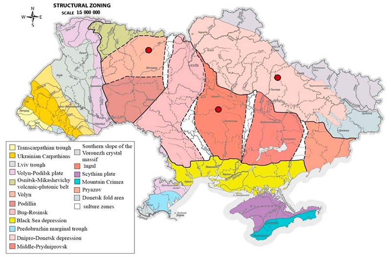
Figure 1
Location of the Krasnokutsk, Zlobich, and Birzuliv deposits on the tectonic map of Ukraine.
Note: I - Ukrainian Shield: 1 - Osnitsk-Mikashevichy volcanic-plutonic belt; Megablocks: 2 - Volyn, 3 - Podillia, 4 - Bug-Rosinsk, 5 - Ingul, 6 - Middle-Prydniprovsk, 7 - Pryazov; suture zones: A - Brusyliv, B - Golovaniv, C - Ingulets-Kryvyi Rih, D - Orikhiv-Pavlograd; Interblock faults: a - Sushchan-Perzhan, b - Teteriv, c - Andrushiv, d - Zvizdal-Zalissia, e - Nemyriv, f - Brusyliv, g - Talniv-Gvozdav, h - Pervomaisk, i - Yadlov-Trakhtemyriv, j - Ingulets, k - Kryvyi Rih-Kremenchug, l - Orikhov-Pavlograd, m - Azov-Pavlograd; II - Volyn-Podilsk plate; III - Lviv trough; IV - Black Sea depression; v - Dnipro-Donetsk depression; VI - southern slope of the Voronezh crystal massif; VII - Predobruzhin marginal trough; VIII - Ukrainian Carpathians; IX - Transcarpathian trough; X - Precarpathian trough; XI - Scythian plate; XII - Donetsk fold area; XIII - Mountain Crimea; Z - Zlobich ilmenite deposit; B - Birzuliv placer; K - Krasnokutsk titanium-zirconium deposit.
3 Stratigraphy of the Krasnokutsk, Zlobychi, and Birzuliv Deposits
Rocks from paleozoic to quaternary age take part in the geological structure of the Krasnokutsk deposit. Paleozoic rocks were discovered in deep wells of the Poltavanaftogazrozvidka trust. Paleozoic formations are represented by deposits of the devonian, carboniferous, and permian systems, which are represented by diabases, limestones, mudstones, gypsum, anhydrites, and other rocks. The relationship of the material composition of the Novi Petrivtsi suite with Paleozoic deposits has not been established. Mesozoic deposits are widespread in the study area. They are represented by a thick layer of variegated clays, sandstones, sands, marls, and white writing chalk of the Triassic, Jurassic, and Cretaceous systems. Upper Cretaceous deposits were discovered in mapping wells of the Poltavanaftogazrozvidka trust. The relationship of the material composition of the Novi Petrivtsi suite with Mesozoic formations has not been established. Paleogene deposits lie on the formations of the Upper Cretaceous. The oldest Paleogene formations are Paleocene deposits. They were opened by wells of the trust "Poltavanaftogazrozvidka" in 1957-1958, these deposits were not tested due to the lack of core material. The geological complex of the Eocene within the deposit is represented by deposits of Kaniv, Buchak, and Kyiv regional tiers. The Kaniv regional tier is represented by two horizons: Lower and Upper. The Lower one is composed mainly of sands with layers of clays and sandstones, the Upper one is composed of argillite-like clays and marls. The sands and sandstones of the Lower horizon are mostly quartz with a large amount of glauconite. The capacity of Kaniv deposits is up to 50 m (Kravchenko 2016).
As part of the Buchak regional tier, two horizons are distinguished: Lower and Upper. The Lower one is represented by greenish-gray and yellow-gray, variegated sands with the inclusion of sandstone, pebbles, and gravel. No significant content of ore minerals has been found among Buchak sand deposits. The average content of collective concentrate is 0.44 kg/t. The main ore minerals in the collective concentrate are hematite, ilmenite, rutile, and zircon. The capacity of Buchak regional tier deposits is from 13 to 74 m. The formations of the Kyiv regional tier are represented by marls, carbonate-free clays, and very fine sandstones. Marl is dense, greenish-grey, and light grey, with a shell-like fracture. The collective concentrate content is 0.2-0.8 kg/t. The collective concentrate consists of hematite, ilmenite, rutile, and zircon. The light fraction is dominated by quartz, glauconite, feldspar, and collophane (Khrushchov et al. 2017; Metaksa, Moldabayeva & Alisheva 2019). The content of collective concentrate in very fine sandstones is from 0.13 to 0.89 kg/t. The average content is 0.4 kg/t. The collective concentrate contains hematite, goethite, magnetite, ilmenite, and rutile. The thickness of the sediments of the Kyiv suite is from 15 to 20 m (Romanov 1976). The geological section of paleogene deposits of marine genesis ends with glauconite sands of the Mezhigirska regional tier, which are ubiquitous in the study area. Sediments of the Mezhigirska regional tier are exposed by a large number of outcrops and wells. The light fraction of glauconite sands is mainly represented by quartz, glauconite, and mica. In addition to iron minerals, the heavy fraction contains ilmenite, rutile, zircon, disthene, sillimanite, garnet, tourmaline, etc. The content of collective concentrate ranges from 0.01 to 3.4 kg/t (average 1.3 kg/t).
Oligocene deposits of the Beretska regional tier include rocks of the Zmiiv and Sivash subregional tiers (subsuite). Zmiiv subsuite is represented by a layer of yellowish-greenish, glauconite, variegated sands and greenish-grey, brown, oily, and shale clays (up to 1.5 m thick). Subsuite capacity from 0.5 to 5 m. Sediments of the Sivash subsuite are represented by horizontal and crooked sands of light gray, greenish-gray with layers of variegated sands, fine-grained, micaceous, with grains of glauconite. The capacity of deposits is up to 15 m. Deposits of the Beretska regional tier are not widespread are blurred in some places. The Neogene geological section begins with deposits of the Novi Petrivtsi regional tier (suite), which in turn is divided into Lower, Middle, and Upper subsuites. The Upper subsuite is composed of sandy, variegated deposits with layers of sandstones of white, yellowish, pink, brown, and brick-red colour. The Middle subsuite is represented by quartz sand, usually light grey, greyish-white, sometimes dirty grey, pink, yellow, and rusty yellow. The Quaternary system is represented by brownish-grey, brown, reddish-brown soils, loams, and loess-like clays. Capacity up to 2 m (Figure 2).
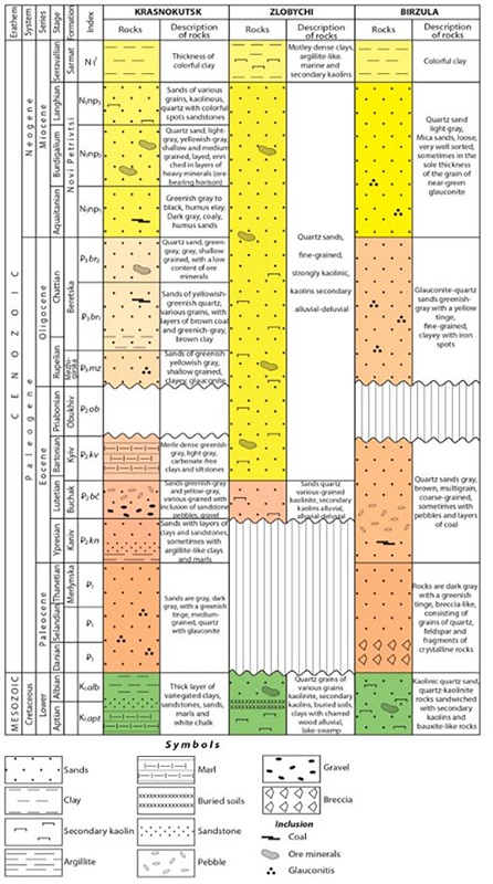
Figure 2
Compiled litostratigraphic column of Krasnokutsk, Zlobychi, and Birzuliv deposits.
The geological structure of the Zlobychi placer ilmenite deposit involves Lower Proterozoic basic and acidic intrusive rocks, their weathering crust and Mesozoic, Cenozoic and Proterozoic sedimentary rocks. The deposit is most fully represented by rocks of the main composition, among which gabbro-anorthosites of the normal series predominate. Gabbro-norites are less common. Gabbro-peridotites are slightly widespread. Mesozoic-Cenozoic formations include the weathering crust of crystalline rocks of the kaolin profile, which includes the zone of partial (kaolinised) and complete kaolinisation (primary kaolinite). The boundaries between zones are conditional, in general terms, the power ratio of the Lower and Upper zones is 1:3. The main ore mineral of the weathering crust is ilmenite, often leucoxenised. Mesozoic formations are represented by Lower cretaceous, mainly Apt-Albian deposits and have a slight distribution within the deposit. They are found in the central part of the deposit, where they are represented by a thickness of different-grained quartz sands and secondary kaolinites with a thickness of up to 7 m. Cenozoic formations are represented by Paleogene, Neogene, and Quaternary sediments. Paleogene. Buchak suite deposits within the deposit have a small distribution. They are represented by different-grained quartz sands and brown clays with a maximum capacity of 5.5 m (Shvaiberov 1998).
Undivided Paleogene-Lower Neogene alluvial deposits are most common in the deposit and are confined to a wide valley-like depression of the crystalline basement. Paleogene-Lower Neogene deposits occur on the eroded weathering crust, Paleogene, or (rarely) Lower Cretaceous deposits. The capacity of Paleogene-Lower Neogene deposits varies from the first tens of centimeters to 18.5 m (average capacity of 3.8 m).
The maximum concentrations of ilmenite are confined to deep depressions in the foundation (such as ravines) in the Lower sedimentary strata, where it is enriched by washing the ilmenite-containing products of the kaoline crust of weathering. As a rule, the content of ilmenite in coarse-grained sands is higher than in fine-grained sands or secondary kaolines. The coefficient of variation of the ilmenite content calculated for all samples involved in the inventory calculation averages 72.8%. Neogene. Miocene-Pliocene deposits are widely distributed within the deposit. Deposits are mainly represented by clays (95-98% of the volume). Loams, sandy loams, sand, and secondary kaolines have a subordinate value. Clays are greyish-brown, brown, with brick-red and dark cherry spots, plastic with a silky fracture. The sandy component of clays is represented by quartz sand, sometimes there are single hematite grains (Figure 2). Deposits of Quaternary age lie in a continuous cover and are represented by lower-, middle-, upper-quaternary, and holocene divisions. The section of the Holocene thickness is completed by a soil-vegetation layer. The soils of district are poor, sandy, and low-yielding (Shvaiberov 1998).
The geological structure of the Birzuliv placer includes labradorites, gabbro-labradorites, and rapakivi granites, their weathering crust, sedimentary sand-clay deposits of the Lower Cretaceous, Neogene, and Quaternary period formations. Occasionally, they contain layers of glauconite-quartz sandstone on clay, less often siliceous, cement.
Kaolinite clays, often sandy and usually located in the upper part of the section of Upper Albian deposits, are of secondary importance. They are absent only in the valleys of rivers and straths, where they were washed out at a later time. Sediments are represented by glauconite-quartz sands, greenish-grey with a yellowish tinge, fine-grained, aleurite-like, well sorted, argillaceous, micaceous, with stripes and spots of iron. Often at the base (1-3 m) sands are variegated, with rare ilmenite grains (Khrushchov et al. 2017).
Deposits of the Neogene system include a thickness of quartz sands mainly of light grey, greyish-white colour. The sands are micaceous, loose, usually well sorted, sometimes thicker in the sole with grains of pale green glauconite. The Upper Miocene-Lower Pliocene includes a horizon of variegated clays.
4 Paleogeographic Conditions of Ilmenite Formation
The Zlobychi ilmenite deposit belongs to the placer continental alluvial genetic type. During the Paleogene-Neogene period, the existence of the Paleo-Irsha valley created a number of positive factors for the formation of the deposit. Firstly, the presence of ore material (ilmenite) near sources. Based on the constructed paleogeographic schemes of the middle course of the Paleo-Irsha and a map of geochemical trends of ilmenite and zirconium, an array of Hraby-Meleniv granitoids is established as the most likely source of ore material wear. The possibility of erosion and re-laying of its own weathering crust, which is also ilmenite-containing (although with a lower ilmenite content), is not excluded (Gurvich & Bolotov 1968; Svivalneva 2014 b ). Secondly, the tectonic regime, which, against the background of intermittent-periodic negative movements, created extreme amplitude movements that differ from ordinary ones in one direction or another by 10-40 m. As a rule, such blocks are confined to areas of joints with different directions of zones. Differentiated movements of the blocks created depression-like and trough shapes in the relief with a stepped bottom profile, in which there is a complex combination of hypsometrically separated subhorizontal and sloping areas. The slope of the surface of individual blocks reaches 150°, and the angle of slope, in general, increases to the sides of depressions. Such conditions localise a number of factors for the release and transport (hydrodynamic activity) of ore material by water flows.
Thirdly, the structural sedimentation factor, which was manifested in the formation of a complex stepped longitudinal and transverse structure of the root bed of the valley and terraced surfaces, which served as a kind of sedimentation traps for ore material. A number of other factors also influenced the formation of the deposit but they had a smaller impact and, accordingly, are not listed here. Figure 3 shows a paleogeographic scheme of the middle course of the Paleo-Irsha, the direction of which almost completely coincides with the direction of the current of the modern river Irsha. Placer-forming formations - gabbro-anorthosite formations of the Volyn massif (including Hraby-Meleniv gabroid body) - are located to the west of the deposit. Based on paleogeographic constructions, three possible branches of the paleo-Irsha valley are predicted, which could be its tributaries and serve as paleotransport arteries for the supply of ore material (Svivalneva 2014b).
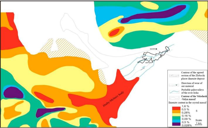
Figure 3
Paleogeographic scheme of the middle flow of the paleo-Irsha.
Notes: 1 - contour of the agreed section of the Zlobychi placer ilmenite deposit; 2 - flow direction (direction of wear of ore material); 3 - probable paleovalleys of the river Irsha and its main tributaries; 4 - contours of the Volodarsk-Volyn and Chopovychi massifs of the Korostensk pluton; 5 - ilmenite content in the crystal massif.
Paleogeographic reconstructions of the Krasnokutsk titanium-zirconium ore deposit are based on the idea of the existence of a continental closed basin in the Miocene period, which included the DDD and US basins, and stretched from the territory of the Western European platform almost to the Pre-Urals and was called "Subparatetis" (Zosimovich, Kulichenko & Savron 1989). As a result of lithostratigraphic studies, it was established that the formation of the deposit occurred in the Middle Novi Petrivtsi time (Miocene). Previously, the existence of a delta was established on the territory of the deposit formation, which indicates the presence of a river artery at that time, which served as the main source of ore-forming minerals (Figure 4). According to studies of predecessors of Gurvich and Bolotov (1968), Tsymbal and Polkanov (1975), the feed source of the Krasnokutsk deposit is sedimentary rocks of Paleogene and Mesozoic age of the DDD and adjacent sections of the Eastern European platform (Voronezh massif and Moscow syneclise) (Ganzha et al. 2019).
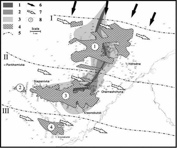
Figure 4
Paleogeographic scheme of the Krasnokutsk deposit of the Middle Novi Petrivtsi subsuite.
Notes: 1-3 - delta: 1 - medium- and coarse-grained sand, 2 - fine- and medium-grained sand, 3 - clay; 4 - position of regressive levels of basin standing (I -II-III); 5 - direction of ore material flow; 6 - direction of movement of longitudinal currents; 7 - contours of ore deposits; 8 - ore fields (1 - Koziivka, 2 - Stepanivka, 3 - Central, 4 - Southern).
Figure 4 shows a paleogeographic scheme of the Krasnokutsk deposit in the Middle Novi Petrivtsi subsuite (Ganzha et al. 2019). At the end of the Lower Novi Petrivtsi period and the beginning of the Middle Novi Petrivtsi period, under the influence of a number of factors, a river artery (probably Pre-Vorskla) was laid, the presence of a delta of which was established on the territory of the field. Later, during the Middle Novi Petrivtsi period, the territory was flooded with Subparatetic waters, as a result of which delta deposits were partially eroded and re-deposited, and the territory of the deposit was in shallow coastal zone. Precipitation of ore material occurred under the conditions of regression of Subparatetic basin. Three positions of regressive pool levels are set. During the first, the Koziev field was formed, during the second - Stepaniv and Central, during the third - Southern. The main source of nutrition for ore material was the river artery, with synchronous flow of ore material due to lateral transfer along the coast currents (direction of movement - from northwest to southeast), washing of underlying and laterally adjacent sediments (Tsymbal & Polkanov 1975).
The formation of the deposit was facilitated by a combination of a number of conditions necessary for placer formation - tectonic, hydrological, hydrodynamic, lithodynamic, geomorphological, and local - structural-sedimentation (Ganzha et al. 2019). At the beginning of the Middle Novi Petrivtsi time, oppositely directed neotectonic movements - ascending, in the areas of placer formations (Voronezh shield, US) and partially intermediate reservoirs, and descending within the sedimentation "marine" basin (Subparatetis). It formed a sedimentation basin with a system of rivers that flowed into it (geomorphological and hydrodynamic conditions) and lithodynamic movement of placer-forming material to this basin. The hydrological regime of the basin (transgressions-regressions) was determined by the volume of river water intake (i.e., it depended on climatic conditions). The sedimentation effects of these fluctuations coincide with those of ordinary transgressions-regressions (with the exception of certain geochemical characteristics). The hydrodynamic conditions of the basin in terms of size and configuration provided the effect of two determining factors of placer formation: longitudinal currents and wave movements (Zhai 2020). Structural sedimentation conditions were manifested in two main genetic forms: inherited and consistent. Inherited ones were caused by the presence of certain structural protrusions and were expressed in the form of bends of the coastline, forming more or less open bays (areas of the Krasnokutsk deposit). Such bends caused optimal hydrodynamic conditions for placer formation, which could be realised if lithodynamic conditions were provided (the supply of sufficient volumes of ore material).
Birzuliv placer of ilmenite forms a unique paragenetic row. Within its limits, industrial ilmenite content is found in the rocks of the crystalline basement, their weathering crust, Apt-Lower Albian continental deposits, which are the product of the re-deposition of eluvial formations and Upper Albian coastai-marine formations, which are the product of the erosion of weathering crust and the washing of Apt-Lower Albian continental deposits. The most ore-bearing is the continental Apt-Lower Albian (Lower Cretaceous) thickness. The formation of Lower Cretaceous continental deposits was preceded by the Triassic-Early Cretaceous era of prominence peneplenisation and intensive chemical and biological weathering of crystalline basement rocks. As a result, planar and linear kaoline and laterite weathering crusts with a thickness sometimes exceeding 120 m were formed on the rocks of different genesis, ages, and petrographic compositions. The Mesozoic weathering crust has become the main source of material for the formation of both Lower Cretaceous and Paleogene continental deposits. At the beginning of the Early Cretaceous (Berriasian-Valanginian epoch), most of the central part of the US was dry land with a climate inherited from the Late Jurassic. Climate humidisation led to an increase in the amount of precipitation, which in turn led to the beginning of the formation of both temporary and permanent river watercourses within the land. Further climate humidisation and differentiated tectonic movements with a general tendency to raise the territory led to the intensification of erosion activity of fluvial flows and the formation of a powerful river network. At this time, the Lebedyn-Balakleya depression was formed, which is one of the Lower Cretaceous River paleovalleys within the north-eastern slope of the central part of the US (Figure 5). Birzuliv placer is located in the upper part of the Lebedyn-Balakleya paleovalley. This arrangement had a positive effect on the supply of ore material since it represented areas of erosion of zones of discontinuous disturbances. There was a process of erosion of the crust by weathering by river flows and their simultaneous transportation by the same river system. The presence of these factors caused an intensive intake of heavy minerals in the alluvium, slowing of flows and concentration of heavy minerals (Svivalneva 2014 a ; Zosimovich, Kulichenko & Savron 1989).
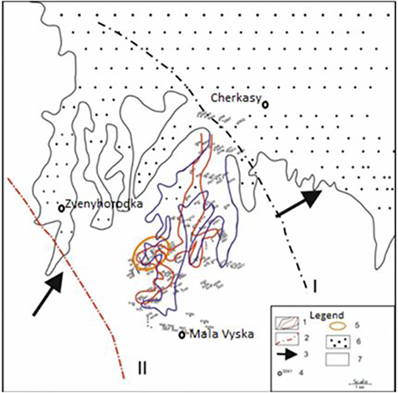
Figure 5
Paleogeographic scheme of the upper paleocourse of the Lebedyn-Balakleya paleovalley.
Notes: 1 - sedimentation levels of the river valley; 2 - position of sea levels; 3 - direction of wear of clastic material; 4 - wells and their numbers; 5 - deposit boundaries; 6 - elevation of denudation and accumulative plains; 7 - lowland of denudation plains.
The transition from one petrographic type of rock to another led to the alternation of narrowed and expanded areas in the valley structure. This caused significant rates and intense erosion within some areas, and a decrease in the fluvial flow rate and intensive accumulation of terrigenous material (including heavy minerals) within others. Considerable concentrations of heavy minerals were found in areas of riverbed expansion, where the water flow rate sharply decreased compared to the narrow channel. The morphology and position of placers during the development of the river valley constantly changed and became more complicated due to the action of proluvial-alluvial, deluvial-alluvial processes, channel migration, and the activity of lateral tributaries. As a result, a complex mosaic picture of the substitution of lithofacies and facies and, as a result, the ore content of alluvial deposits was formed (Khrushchov et al. 2017).
In Albian, there is a significant sea transgression, which occurred both from the south and from the northeast. Sea transgression used river paleovalleys. The gradual increase in the basis of erosion led to the attenuation of the erosion activity of rivers, the suppression of river runoff by inclined processes. With the increase in sea transgression from the south and northeast, river mouths were loaded with the formation of deltas and estuaries. The formation of sediments occurred in the shallowest coastal part of the sea basin (this is indicated by a low content of glauconite, a poor degree of sorting of clastic material, mainly coarse-grained material). During the transgression process, the formed continental sediments underwent partial erosion. In the Late Cretaceous era, the marine basin expanded significantly, and at the end of the Late Cretaceous period, the sea regressed due to laramian orogenesis. In the Paleocene, the research area was a raised denudation plain that was dissected by a river grid (Ganzha et al. 2019; Kravchenko 2016).
5 Structural-Lithological Models of Ilmenite Deposits
Based on the coordinates and description of wells, data from testing wells for ilmenite and the author's field studies, structural-lithological models of the Krasnokutsk titanium-zirconium deposit, Zlobychi ilmenite deposit, and Birzuliv placer were constructed. The resulting simulation visualisations were analysed and compared with paleogeographic reconstruction data. As a result, conclusions were drawn about the conditions and features of ilmenite distribution over the area of deposits (Romanov 1976).
Krasnokutsk titanium-zirconium deposit from the standpoint of modelling is a sample of an object of relatively simple geological structure (as an example of a placer of coastal-marine geological and genetic type), but with a rather complex distribution of ore bodies and technological properties, which is confirmed by the results of modelling. The Krasnokutsk deposit is a group of placer fields that form a polygonal area 16 km long and 3-4 km wide, stretching from Southwest to Northeast. Romanov (1976) identified four ore fields here: Central, Stepaniv, Southern, and Koziiv (Kravchenko & Khrushchev 2015). On the model map (Figure 6), three bands of increased concentrations are distinguished: the middle one, with maximum contents, corresponding to the Central and Stepaniv fields; the northern one (Koziiv field) and the Southern one (the site of the same name). These bands have a sublatitudinal direction, which corresponds to the general scheme of placer formation for this part of the sedimentation basin (the shoreline of the standing basin).
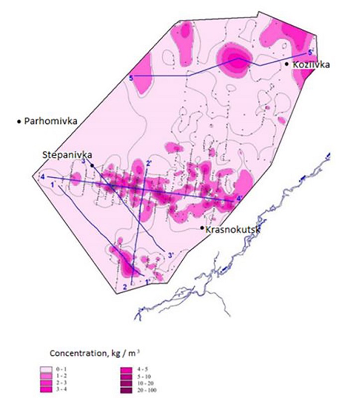
Figure 6
Distribution of the average ilmenite content on the territory of the Krasnokutsk deposit.
Further detailing of the three-dimensional representation of the distribution of mineralisation in the rock mass of the deposit is based on the analysis of model profiles. From this analysis, it becomes clear that the ore thickness is not a continuous thickness but is a row of ore bodies and their series. In sections of individual placers, ore bodies are lenses, less often - lenticular layers with a thickness of 2-6 m, which are sometimes traced at a distance of up to several kilometres. In plan, ore lenses have the appearance of spots of complex contours, elongated mainly in the sublatitudinal direction, sometimes in the southeast, southwest, and other directions. According to geological exploration data, the total content of ilmenite in ore bodies varies from 0.1 to 120 kg/m3 in the field in general, including separately by fields, the ilmenite content is: Central field 2.5-43 kg/m3, Stepaniv field 1-25 kg/m3, Southern field 2-19 kg/m3, Koziiv field 2-13 kg/m3. Thus, the ore characteristics of the Krasnokutsk titanium-zirconium deposit correspond to its geological and genetic characteristics. The formation of three bands of increased ilmenite concentrations corresponds to three lines of standing of the coastline of Subparatetis basin. The ore thickness is not a continuous strip but is represented by a number of series since the deposit belongs to the long-distance transfer type (i.e., it is located quite far from the power source). In this case, the sedimentation of ore material depends on a number of favourable conditions, which were described above (Kravchenko & Khrushchev 2015).
Birzuliv placer is a special paragenetic row with ore-bearing Mesozoic weathering crust and Apt-Lower Albian continental (alluvial) and Upper Albian coastal-marine deposits. The ore content of the weathering crust is conditioned upon the increased content of ilmenite in crystalline rocks. The thickness of the weathering crust varies widely - from 8 to 36 m, on average 23 m. The maximum capacities are mainly confined to tectonically weakened zones, contacts of various petrotypes of rocks. The capacity of the weathering crust also largely depends on further erosion, which is intense in the axial parts of the paleovalley. In the weathering crust profile of the main rocks, the following zones are distinguished (from top to bottom): hibsite and kaolinite-hibsite; kaolinite; hydromica-kaolinite; montmorillonite-kaolinite; disintegration and leaching. A considerable part of the section consists of disintegration and leaching zones, hydromica-kaolinite, and kaolinite. The weathering crust contains ilmenite everywhere in high concentrations. The distribution of ilmenite in the weathering crust is uneven and increases in the direction from its sole to the surface. In the zone of disintegration and leaching, the ilmenite content is 31.7 kg/m3, in the upper part - kaoline zone) - 138 kg/m3. Ilmenite forms scattered inclusions, streaks, and lenticular bodies. In the weathering crust of rapakivi granites, there are the following zones (from top to bottom): kaolinite; hydromica-kaolinite; sericite-kaolinite; disintegration and leaching. The first two upper zones are the most common. The ilmenite content in the weathering crust of granites is insignificant - 0.5-25 kg/m3 (Figure 7) (Khrushchov et al. 2017). The increased powers of the ilmenite-bearing weathering crust have a meridional extension that coincides with the direction of the paleovalley of the Lebedyn-Balakleya depression.
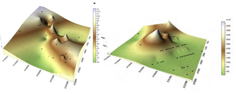
Figure 7
Thickness and level of ilmenite continental deposits of the Birzuliv placer.
Notes: a - distribution of the thickness of ilmenite-bearing sand formations; b - lateral distribution of the content of ilmenite in continental formations.
Lower cretaceous deposits everywhere with erosion lie on the weathering crust and are divided into continental (alluvial) and coastal-marine by genesis. The formation of the Birzuliv placer is directly related to the Lebedyn-Balakleya erosion-tectonic paleovalley and the activity of fluvial flows within its borders. The presence of a river artery served as a place of erosion and washing of the weathering crust, a place of concentration of ore material in sedimentation traps of alluvium. Continental deposits of the lower cretaceous were preserved in the form of separate narrow bands. The relief of the surface and sole of deposits is mostly smooth, with small depressions and elevations. Continental deposits are represented by grey fine- and medium-grained quartz kaoline sands and secondary kaolines. The thickness of the sands is from 1.5 to 8.9 m, on average - 3.0 m. The thickness of the sands increases in a northern direction and corresponds to the general slope of the channel part of the paleovalley. The increased thickness of ilmenite-bearing sands is confined to the core subfacies. The ilmenite content in alluvial deposits is uneven, varying from a few kilograms per cubic meter to 343 kg/m3 in individual wells (Khrushchov et al. 2017). The maximum ilmenite content is 758 kg/m3. The most ilmenite-rich sand rocks which are confined to the thalweg of the paleovalleys (Kravchenko 2016).
Secondary kaolines occur in the form of small layers and individual lenses that lie both inside sand deposits and in their soles. The power of secondary kaolines is more or less sustained laterally. Secondary kaolines are light grey or white rocks that are oily to the touch. The content of ilmenite in secondary kaolines in some cases is 300 kg/m3. In general, the ilmenite content in fluvial continental formations has a direct correlation with their thickness (with an increase in the total capacity of continental formations, the ilmenite content increases in them) and is limited to an increase in the raft relief, which served as a mechanical barrier to the ilmenite concentration (Khrushchov et al. 2017). Coastal-marine glauconite-quartz sands of the Lower Cretaceous within the Birzuliv placer are represented by shallow facies of the upper Alb, the thickness of which reaches 12.0 m. Their formation occurred due to the erosion of eluvial formations and the washing up of underlying continental sediments. The presence of rich ilmenite placers in the denudation region led to the formation of such placers in coastal-marine facies. The shape of the placer is isometric, oval. The placer is 4 km long and 2 km wide. The central part is most enriched with ilmenite (average content 173 kg/m3). The ilmenite content reaches 598 kg/m3. In the vertical section, the ilmenite content increases from the roof to the bottom of the placer. Thus, within the Birzuliv placer, rocks of the crystalline basement, their weathering crust, continental (alluvial) and marginal-marine deposits of the lower cretaceous are ilmenite-bearing, the total ore-bearing potential of which is of considerable economic interest (Svivalneva 2014 a ; 2014b).
The Zlobychi ilmenite deposit is an example of modelling alluvial placers with a rather complex combination of structural, lithofacial, and facialised conditions for the concentration of ore material. To establish the regularities of ilmenite distribution at the Zlobychi placer deposit, undivided Paleogene-Lower Neogene alluvial deposits were modelled. In general, according to the formation characteristics, the deposit contains two thicknesses: mainly psammitic composition (undivided Paleogene-Neogene deposits) and the weathering crust of the crystalline basement (kaolin profile). The average ilmenite content in the contour of the balance reserves of the alluvial part of the placer is 56.2 kg/m3, in the weathering crust - 66.6 kg/m3. Analysis of the distribution of average ilmenite content of the Zlobychi deposit (Figure 8) showed that the flow spread occurred from the west and northwest (Svivalneva 2014 a ; 2014b).
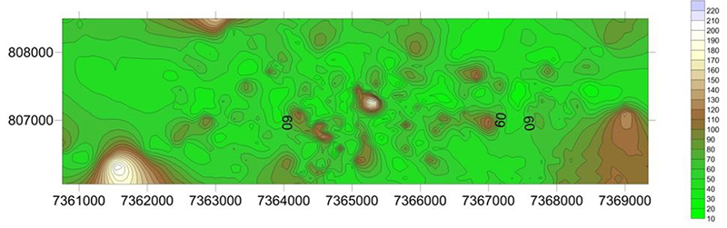
Figure 8
Distribution of the average ilmenite content on the territory of the Zlobychi deposit, kg/m3.
Local depressions in the terrain were traps where ilmenite accumulated. High concentrations of ilmenite are confined to the floodplain facies, below the confluence of tributaries, and are present mainly in fine-grained kaoline sands, sometimes in variegated sands of the shear facies. The dependence of the distribution of ilmenite, depending on the lithological composition of rocks, is established. In more coarse-grained sands, the ilmenite content is higher than in fine-grained sands or secondary kaolines (northern part of the placer). Such deposits are common in the central and eastern parts of the deposit. In general, lithological-facial conditions of sedimentary accumulation over a long period of time (about 60 million years) caused an uneven, jet, lenticular distribution of ilmenite in Paleogene-Neogene deposits, which make up to 80% of the volume of the productive reservoir in the placer. The weathering crust in the central part of the placer is sometimes eroded and there is an inverse relationship between the thickness of the formation and the content of ilmenite. According to the section, ore mineralisation is mainly confined to the zone of complete kaolinisation (Zosimovich, Kulichenko & Savron 1989). The most altered (leucoxenised) ilmenite should be expected within the ancient lake-like depressions (northern part of the placer), valley bottoms (central part), and the confluence of flowing with the Zlobychi paleovalley - western part, corresponding to the flowings of the paleovalley. Anomalous values of ilmenite variability can be traced in the north-western direction due to the northwestern orientation of tectonic structures. The least altered ilmenite is found in modern alluvial deposits of the Irsha river and its tributaries. Analysis of the planar distribution of ilmenite, its relationship with certain lithofacies, facies, and placer morphology allowed establishing two sources of ore material intake: transportation by the river artery and erosion of the weathering crust by the same artery. In this case, the paleo-Irsha valley was not only a way for ore material to enter but also created a number of conditions for its accumulation (depressed areas in the paleovalley relief that served as sedimentation traps).
6 Conclusions
The Krasnokutsk deposit, as an object of coastal-marine formation, is a polygonal area where the dependence of increased ilmenite concentrations on the levels of standing of the coastline of water area is clearly traced. The study of paleogeographic conditions of formation allowed establishing the presence of a delta. According to, it is concluded that the main source of supply of ore material was the River Artery.
The Zlobychi deposit, as an example of the alluvial type of genesis, is an elongated band of increased ilmenite concentrations (which corresponds to the paleoriver valley floor) with local maximum inclusions (belonging to sedimentation traps of the flood plain facies). Comparison of the paleogeographic conditions of the deposit formation with the map of the crystalline basement allowed establishing that the main source of ilmenite intake was the Hraby-Meleniv body. However, this theory requires laboratory confirmation and is the subject of further research.
Birzuliv placer is a representative of a special paragenetic series of combinations of ore-bearing weathering crust, continental (alluvial), and marginal-marine deposits. Increased ilmenite content in it is present in all three thicknesses but they differ in the nature and content of the distribution. The weathering crust and the continental thickness had a two-way dependence. On the one hand, the leaching of heavy minerals from the weathering crust contributed to an increase in the content of ilmenite in alluvial deposits; on the other hand, the mechanism of action of the river artery affected the power of the weathering crust and, accordingly, the total content of collective concentrate in it. A similar relationship was observed between continental and marine sediments. In marine sediments, there is a slight and scattered distribution of ilmenite over the area, which was largely the object of leaching of the underlying alluvial thickness.
Thus, using the example of three deposits of different geological and genetic types, the effectiveness and observability of digital structural-lithological modelling as a method for studying deposits of different types of geneses is confirmed. The construction of structural-lithological models is not sufficiently informative without genetic reconstructions, so it becomes advisable to combine the methodological principles of digital structural-lithological modelling with paleogeographic data for studying the structural and material characteristics of various geological and genetic types of deposits. This combination is called retrospective static modelling and is actively developed by the staff of the Institute of geological sciences of the National Academy of Sciences of Ukraine, M.P. Semenenko Institute of geochemistry, mineralogy, and ore formation in National Academy of Sciences of Ukraine, and the Institute of geography of National Academy of Sciences of Ukraine.
7 Acknowledgements
The research that forms the basis of this paper is supported by a grant from the National Academy of Sciences of Ukraine by research laboratories/groups of young scientists of the National Academy of Sciences of Ukraine to conduct research in priority areas of science and technology development "Retrospective-static modelling of titanium-zirconium placers in the Ukrainian placer province" (State registration number: 0121U110428).
8 References
Ganzha, E.A., Lalomov, A.V., Chefranova, A.V., Grigoreva, A.V. & Magazina, L.O. 2019, 'Lithostructural geological-genetic model and mineral composition of the Krasnokutsk rare metal-titanium placer deposit (Ukraine)', Lithology and Mineral Resources, vol. 54, no. 6, pp. 465-79, DOI:10.1134/S002449021906004X.
Gurvich, S.I. & Bolotov, A.M. 1968, Titanium-zirconium placers of the Russian platform and prospecting issues, Nedra.
Khrushchov, D.P., Kovalchuk, M.S., Remezova, E.A., Lalomov, A.V., Tsymbal, S.N., Bosevskaya, L.P., Lobasov, A.P., Ganzha, E.A., Dudchenko, Y.V. & Kroshko, Y.V. 2017, Structural and lithological modeling of sedimentary formations, Interservis.
Kravchenko, O.A. 2016, 'Structural-lithological geological-genetic model of the Krasnokutsk genus of titanium-zirconium ores', Institute of Geological Sciences of the National Academy of Sciences of Ukraine.
Kravchenko, O.A. & Khrushchev, D.P. 2015, 'Modeling of titanium-zirconium placers on the example of the Krasnokutsk deposit', Collection of Scientific Works of the Ukrainian State Geological Exploration Institute, vol. 3, pp. 104-15.
Metaksa, G.P., Moldabayeva, G.Z. & Alisheva, Z.N. 2019, 'Mechanism of structure formation in fluid-bearing minerals', Mining Informational and Analytical Bulletin, vol. 2, pp. 78-84, DOI:10.25018/0236-1493-2019-02-0-78-84.
Radwanek, B. 2020, 'Tendencies of technical and technological innovation in mineral deposits exploration, mining and mineral processing', Przeglad Geologiczny, vol. 68, no. 9, pp. 675-81.
Radwanek-Bąk, B., Sobczyk, W. & Sobczyk, E.J. 2020, 'Support for multiple criteria decisions for mineral deposits valorization and protection', Resources Policy, vol. 68, 101795, DOI:10.1016/j.resourpol.2020.101795.
Romanov, I.S. 1976, Geology and conditions of formation of zirconium-titanium placers of the Dnieper-Donetsk depression, Naukova Dumka.
Shevko, V.M., Aytkulov, D.K., Atamkulov, B.B., Izbaskhanov, K.S. & Naimanbaev, M.A. 2017, 'Complex electrothermic processing of the poor oxide ore of the Achisay deposit', News of the National Academy of Sciences of the Republic of Kazakhstan, Series of Geology and Technical Sciences, vol. 4, no. 424, pp. 177-83.
Shevko, V., Karataeva, G., Tuleev, M., Badikova, A., Amanov, D. & Abzhanova, A. 2018, 'Complex electrothermal processing of an oxide zinc-containing ore of the Shaymerden deposit', Physicochemical Problems of Mineral Processing, vol. 54, no. 3, pp. 955-64.
Shvaiberov, S.K. 1998, Detailed exploration of the Valki Gatskovskiy placer ilmenite deposit in the Zhytomyr region of Ukraine, Sevukrgeologiia.
Singer, D.A. 2018, 'Comparison of expert estimates of number of undiscovered mineral deposits with mineral deposit densities', Ore Geology Reviews, vol. 99, pp. 235-43, DOI:10.1016/j.oregeorev.2018.06.019.
Svivalneva, T.V. 2014a, Geology and ore-bearing capacity of Zlobytsia ilmenite placer deposit (Ukrainian shield), Institute of Geological Sciences of the National Academy of Sciences of Ukraine.
Svivalneva, T.V. 2014b, 'Zirconium provenance area for upper irshansk group of titanium-zirconium ores deposits', Geological Journal, vol. 1, pp. 109-15.
Tsymbal, S.N. & Polkanov, Y.A. 1975, Mineralogy of titanium-zirconium placers of Ukraine, Naukova Dumka.
Zhai, Y. 2020, 'On the method of thinking in studying mineral deposits', Earth Science Frontiers, vol. 27, no. 2, pp. 1-12, DOI:10.13745/j.esf.sf.2020.3.6.
Zosimovich, V.Y., Kulichenko, V.G. & Savron, E.B. 1989, 'Subparatetis of Eastern Europe', Geological Journal, vol. 6, pp. 95-97.
Funding information
Data availability statement
Author notes
E-mail: Ganzha-Ol@ukr.netE-mail:t_okholina@meta.uaE-mail:ykroshko@ukr.netE-mail:kuzmanenko.halyna@gmail.comE-mail:myron_Kov@ukr.net
Conflict of interest declaration