Article
Spatial and Temporal Variability of Groundwater Quality Parameters in the Bauru Aquifer System (São Paulo State, Brazil)
Variabilidade Espacial e Temporal de Parâmetros de Qualidade da Água Subterrânea no Sistema Aquífero Bauru (Estado de São Paulo, Brasil)
 Isadora Vitali Lobo isadora.vitali@unesp.br
Olavo Tozete Tercini olavo.tercini@unesp.br
José Augusto Di Lollo jose.lollo@unesp.br
César Gustavo da Rocha Lima cesar.lima@unesp.br
Isadora Vitali Lobo isadora.vitali@unesp.br
Olavo Tozete Tercini olavo.tercini@unesp.br
José Augusto Di Lollo jose.lollo@unesp.br
César Gustavo da Rocha Lima cesar.lima@unesp.br
Spatial and Temporal Variability of Groundwater Quality Parameters in the Bauru Aquifer System (São Paulo State, Brazil)
Anuário do Instituto de Geociências, vol. 46, 53748, 2023
Universidade Federal do Rio de Janeiro
Received: 01 August 2022
Accepted: 16 December 2022
Abstract: Chemical substances can be harmful to humans when present in water at concentrations above the limits permitted by legislation. The present study analyzes the spatial-temporal variability of barium, chromium, nitrate and vanadium concentrations in groundwaters of the Bauru Aquifer System (BAS). For this purpose, triennial water-quality monitoring data (2016-2018) were acquired from CETESB (São Paulo Environmental Company). Descriptive statistical methods and geostatistical techniques (kriging) were applied. Results attest the spatial dependence of the water-quality parameters along time. Variograms indicate spatial determination coefficients (R²) between 0.435 and 0.961. The municipality of Presidente Prudente has the worst scenario, with estimates chromium and vanadium above the Maximum Allowed Values (MAV). The fact that most of licensed wells exploit water for urban supply makes the results worrying and shows up that public agencies must take some actions to decrease these concentrations.
Keywords: Contamination, Water resources management, Kriging.
Resumo: Algumas substâncias químicas podem causar efeitos nocivos à saúde humana quando presentes nas águas em concentrações acima do limite permitido por legislação. Diante disto, o presente trabalho analisou a variabilidade espaço-temporal das concentrações do bário, crômio total, nitrato e vanádio nas águas do Sistema Aquífero Bauru. Para tanto, utilizou-se dos dados de monitoramento trienal (2016 - 2018) da Companhia Ambiental de São Paulo (CETESB). Realizou-se a análise estatística descritiva e posteriormente a aplicação de técnicas geoestatísticas. Os resultados permitiram comprovar a dependência espacial para as substâncias a partir dos variogramas obtidos, os quais indicaram coeficientes de determinação espacial (R2) entre 0,435 e 0,961. A área que merece maior atenção encontra-se na região de Presidente Prudente, com estimativas para crômio total e vanádio acima dos Valores Máximos Permitidos (VMP) combinados. O fato de grande parcela dos poços ser destinada para abastecimento urbano torna os resultados preocupantes e evidencia que os órgãos públicos devem tomar medidas para diminuir estas concentrações.
Palavras-chave: Contaminação, gestão de recursos hídricos, krigagem.
1 Introduction
Groundwater emerges as an option to supply the population’s water demands due to the limitations of the surface springs use throughout the planet (Villar 2016; Carvalho et al. 2020). Groundwater extraction in Brazil accounts for about 17,580 million m³/year, and the State of São Paulo is the largest water consumer, totalizing circa 484 million m³/year (Hirata et al. 2019).
Bauru Aquifer System (BAS) is one of the major sources of groundwater in the São Paulo State due its good quality and easy exploration. The BAS extends over an area of 96,880 km², covering the western half of the State of São Paulo. It consists of sedimentary rocks of the Bauru and Caiuá groups, which unconformably overlie the Serra Geral Formation basalts. Regionally it behaves as a free aquifer, but in some places, it may be confined or semi-confined (São Paulo 2005, 2011). The typical BAS lithologies are fine to coarse-grained sandstones (Garpelli & Gastmans 2020). The average thickness is circa 100 m, with the highest thicknesses exceeding 300 m and being preserved in the region of Marília (Kiang, Stradioto & Silva 2016). The productivity of BAS is between medium to high and the water is of good quality for public supply and human consumption. Recharge takes place throughout its extension, which is a characteristic related to its behavior as a free aquifer, but it represents a higher risk of pollution (Iritani & Ezaki 2012).
BAS is naturally vulnerable because it is an underground aquifer with direct recharge (Romagnoli & Manzione 2018). Another worrisome factor is that the discharge areas of the BAS, coincident on the banks of rivers and tributaries present in their extension, also present high rate of vulnerability to contamination (Rosenberger et al. 2013; Coraça & Helene 2021).
Polluting sources can be natural, related to weathering that causes the dissolution of rocks, or resultant from industrial, agricultural, and domestic anthropic activities, including a variety of pollutants, such as pathogenic microorganisms, chemical, organic and inorganic compounds, and metals, among others (Canato et al. 2014; Qureshi et al. 2021). Groundwater quality has been progressively reduced over the years due to different human activities (Bertolo, Hirata & Aly Junior 2019). Thus, as the use of groundwater expands, water quality problems increase in similar proportions (Stradioto, Teramoto & Chang 2019). In this context, groundwater quality promotes great impact on water security, deserving close attention (Liu et al. 2021), because it is a critical component for the management of water demands from society (Nunes, Aravena & Parker 2021).
Among the parameters monitored in BAS, barium, nitrate, chromium, and vanadium concentrations are highlighted for constantly reaching values above the MAV - Maximum Allowed Values (CETESB 2013, 2016, 2019), as established by the Brazilian Ministry of Health (Brasil 2011, 2021).
A detailed analysis, considering the spatial amplitude of water parameters areas are with values above the maximum legally allowed is extremely relevant for management and decision-making in the region of interest. Considering the magnitude of BAS and that monitoring takes place at localities distributed throughout it, geostatistics stands out as an important tool for the analysis of groundwater quality (Lima et al. 2020), once water quality variables, if distributed in time and space in a structured/organized way, can define a probability of occurrence function (Yamamoto & Landim 2013).
Use of geostatistics to analyze the spatial variability of groundwater has been widespread worldwide, as demonstrated by Drias et al. (2020) in Algeria, Rashid et al. (2021) in Pakistan, Osiakwan et al. (2021) in Ghana, and Joodavi et al. (2021) in Iran. In Brazil, studies carried out in BAS also contribute to a better understanding of the spatial distribution of the water quality parameters of this system (Vicente, Lima & Marques 2018; Manzione & Castrignaro 2019; Lima et al. 2020; Lourencetti et al. 2020; Manzione, Silva & Castrignaro 2020).
The present study analyzes and characterizes the spatial and temporal variability of barium, chromium, nitrate and vanadium concentrations in the Bauru Aquifer System (BAS), in order to investigate the spatial dependence of groundwater quality parameters in this system.
2 Materials and Methods
2.1 Study Area
Data compiled for this study come from monitoring wells installed in the Bauru Aquifer System (BAS) located in the NW of the State of São Paulo. Monitoring wells cover an area of approximately 40% of the State, which is delimited by the following geographic coordinates: 48º 19' 35.45" S and 19º 48' 18.71" W and 52º 17' 22.73" S and 22º 40' 45.74" W (Figure 1).
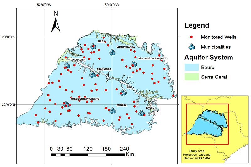
Figure 1
Study area (CETESB monitoring wells, 2016-2018).
2.2. Water Quality Data
Barium (Ba), total chromium (total Cr), nitrate nitrogen (Ni or NO3-) and vanadium (Va) concentrations were obtained from triennial (2016-2018) groundwater-quality monitoring data (Quality Network) made available by the Environmental Company of the State of São Paulo (CETESB 2019).
Analytical methods used to determine water quality parameters followed the criteria established in the publications of the Standard Methods for the Examination of Water and Wastewater (APHA AWWA WEF), the Brazilian Association of Technical Standards (NBR ABNT), the United States Environmental Protection Agency (USEPA), and the International Standardization Organization (ISO), as described in CETESB (CETESB 2016, 2019).
The parameters chosen for this study are those considered harmful to human health. Preliminary analyses of CETESB data indicated that the concentrations of these parameters from 2016 to 2018 reached values above MAV - Maximum Allowed Values (Brasil 2011, 2021). Vanadium was excluded from the 2021 ordinance (Brasil 2021), but it is still regarded as potentially harmful to health by the World Health Organization (WHO 2000, 2011). MAV for each element are presented in Table 1.
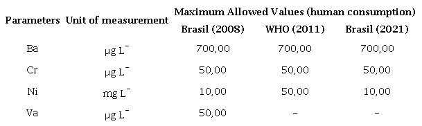
Parameters: Ba = Barium, Cr = Total Chromium, Ni = Nitrate, Va = Vanadium.
Data analyzed in this study corresponds to the 2016-2018 triennium. A total of 97 well logs were examined. It is noteworthy that not all wells were sampled in the same year/period, but usually sampling was performed every six months each year in March-April (end of the rainy season, first semester) and in September-October (end of dry season, second semester). Parameters were identified with numbers, according to the year (16 = 2016; 17 = 2017; 18 = 2018), followed by the semester (1 = first semester; 2 = second semester). These data were organized and tabulated in spreadsheets for subsequent statistical and geostatistical analysis.
2.3 Geostatistical Analysis
For each parameter, the classical descriptive statistical analysis was performed. Spatial dependence was analyzed using the Software Gamma Design Software GS+ 7.0 (Robertson 2004). The simple experimental variogram was calculated for each parameter individually, assuming intrinsic stationarity (Yamamoto & Landim 2013), according to the Equation 1 (Lima et al. 2020):
where γ(h) is the number of observation pairs Z(xi) and Z (xi + h), separated by a distance h.
For variogram adjustments, the following criteria were observed (Lima et al. 2020): a) the lowest sum of the squares of the deviations (SQD); b) the highest spatial determination coefficient (R²) and, c) the highest spatial dependence evaluator (ADE), where: a) ADE ≤ 25% = weakly dependent; b) 25% < ADE ≤ 75% = moderately dependent, and c) ADE > 75% = highly dependent.
The final definition of the adjustment model and of number of interpolating neighbors for kriging was performed using as parameter the highest correlation coefficient (r) between observed vs. estimated value of cross-validation (CV). Thus, the cross-validation process, which consists of removing each observation belonging to the data set with subsequent estimation of its value, at ordinary kriging interpolation method (Yamamoto & Landim 2013), was used to checking the reliability of each model adjusted math. Therefore, the final model chosen was the one that best estimated the observed values, that is, the one that produced a linear regression equation between the values observed, depending on the estimated values the closest to the bisector (intercept equal to zero and slope = 1) (Isaaks & Srivastava 1989).
After this stage, the interpolation was performed by ordinary kriging, since it is an unbiased linear estimation technique (Yamamoto & Landim 2013). Estimates were made using the Equation 2 (Lima et al. 2020):
where z* is the value to be estimated at the unsampled point x0; N is the number of measured values z(xi) involved in the estimation, and λi the weight associated with each measured value z(xi).
The kriging maps produced in the GS+ software were exported in numerical grid format to the Spring v.5.4 software (Camara et al. 1996) where the data integration of the different parameters/periods analyzed was performed to generate the final map. For that, a simple operation of Spatial Language of Algebraic Geoprocessing was used. The final layout was produced using ArcMAP® v.10.3 (ESRI 2013).
3 Results and Discussion
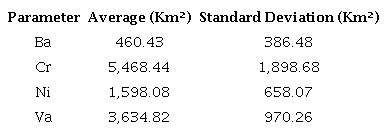
3.1 Descriptive Statistics
The results obtained from descriptive statistical analysis of the selected water-quality parameters are presented in Table 2.
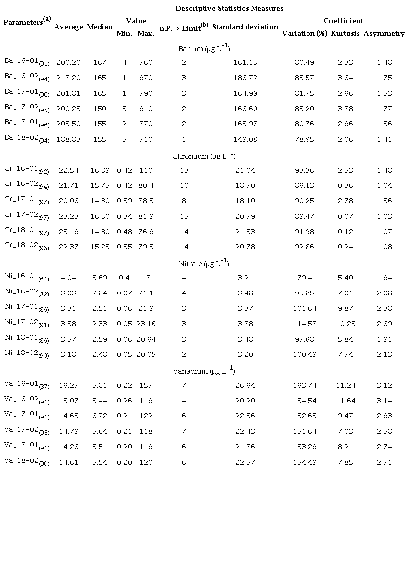
(a) Parameters: Ba = Barium, Cr = Total Chromium, Ni = Nitrate, Va = Vanadium, followed by the respective year, semester, and sample number in parentheses; (b) n.P.> Limit = number of monitoring wells that presented values above the Maximum Allowed Value.
Mean values show that, in general, the analyzed parameters tend to be within the maximum limits (MAV) established by legislation (Brasil 2011, 2021). However, some values are very close and above MAV for isolated wells.
During the whole 2016-2018 period, concentrations above 10 μgL-¹ were observed for NO3- in 2 to 4 wells, involving the municipalities of São José do Rio Preto, Quatá and Parapuã (Table 2). Ba concentrations above MAV (700 μgL-¹) were obtained for 1 to 3 wells, involving the municipalities of Oriente and Pompéia. Total of 74 wells were above the MAV of Cr (Table 2). Values greater than 100 μgL-¹ indicate that water is inappropriate for irrigation (Brasil 2008).
Vanadium concentrations above MAV (50 μgL-¹) were observed in 4 to 7 well logs (Table 2). It is noteworthy that for the 2016-2018 period, values above 100 μgL-¹ were also observed. So, water was inappropriate for both irrigation and animal watering (Brasil 2008).
Another factor identified through statistical analysis is the occurrence of positive asymmetry for data regardless of parameter and analyzed period. The occurrence of positive asymmetry indicates that there is no normal distribution between the parameters analyzed, however, this result does not prevent the use of geostatistical techniques (Cressie 1991), and their transformation is to take on a normal distribution only a recommendation (Lundgren et al. 2017). Figure 1 refers only to wells within BAS that belong to the CETESB monitoring network. One should have in mind that other wells exist in BAS for a variety of purposes, such as irrigation and domestic and industrial supply and that may be exploiting groundwater with NO3-, Ba, Cr and Va concentrations above permissible values.
Montanheiro and Chang (2016), Vicente, Lima and Marques (2018), Stradioto, Teramoto and Chang (2019), and Marques et al. (2019) found concentrations above MAV for NO3- in the Bauru Aquifer groundwaters. Siste and Souza (2013), Mataveli et al. (2018), Lima et al. (2020) and Oliveira et al. (2021) reported the presence of Cr, Ba and Va concentrations above MAV in BAS. Thus, these authors corroborate our results reporting concentrations of human risk chemical elements produced by anthropic and natural agents in BAS.
Coefficient of variation (CV) values obtained in this study are between 78.95 and 163.74% (Table 2). According to Pimentel-Gomes and Garcia (2001), both in the rainy and dry seasons, all parameters presented very high variability, which can be attributed to the extension of the study area. Geological characteristics and anthropic factors may directly contribute to high CV values, once recharge in BAS, because of its free aquifer characteristics (Iritani & Ezaki 2012), occurs by rainwater infiltration throughout the whole area.
3.2 Geostatistical Analysis
The results of the geostatistical analysis are shown in Table 3. The data yielded satisfactory variograms adjustments regarding all variables both in the first and second semester of each year, taking into account the intrinsic hypothesis by stabilizing the variograms and confirming the spatial dependence, with no need for conversions.
The best variogram adjustment (Table 3) was to the spherical model, except for vanadium, which yielded better adjustments to the Gaussian model for the 2016-02, 2017-01 and 2018-01 periods. In a joint analysis of the adjustments using the mean values presented in the descriptive statistics, the seasonal variation between the rainy and dry periods, excepting NO3- (which showed differences in range between periods), may not consist of a factor that significantly alters the parameters analyzed regarding the best variogram adjustment.
All parameters yielded good adjustments and estimation maps by kriging. Regarding Ni (Table 3), the evaluation of variogram parameters indicated satisfactory adjustments to the spherical model with R2 values of between 0.566 and 0.804, ranges from 34.6 to 165.1 km, and r (cross-validation) between 0.192 and 0.546. For Ba ranges varied from 64.8 to 75.1 km, R² between 0.901 and 0.950, and r between 0.586 and 0.666. For total Cr, R² varied between 0.824 and 0.947, ranges from 65.8 to 90.7 km, and r from 0.662 to 0.796. Finally for Va, data showed better adjustments to the spherical and gaussian models, with R² ranging from 0.849 to 0.961, ranges between 47.4 and 77.4 km, and r from 0.579 to 0.709.
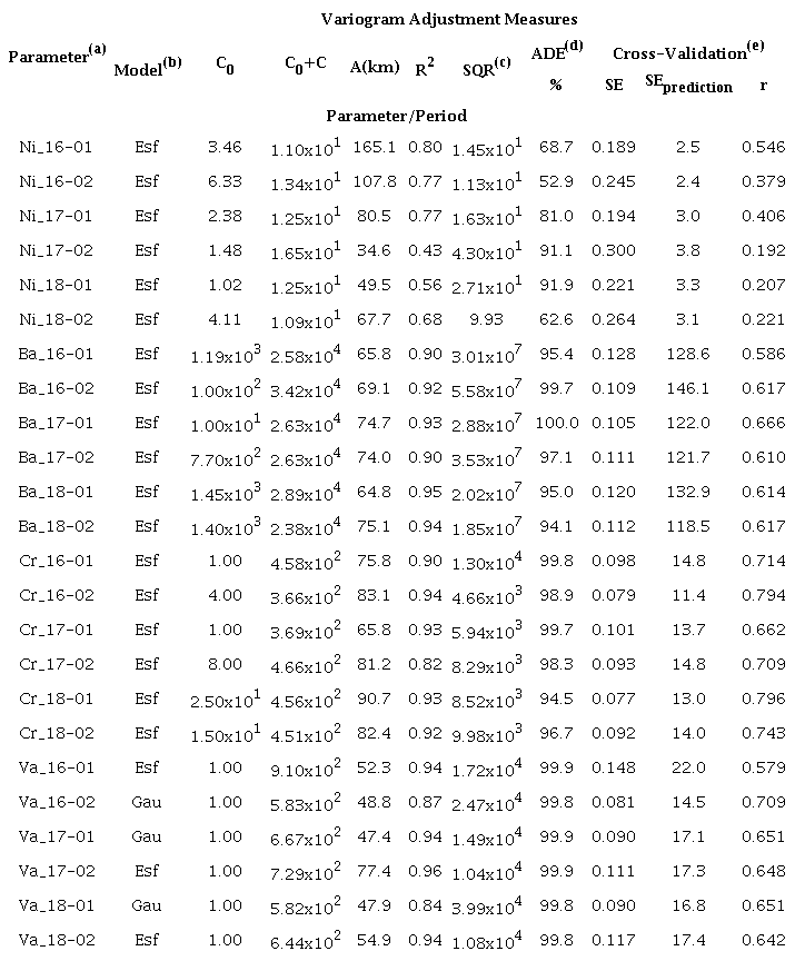
(a) all parameters/periods evaluated presented at least 30 pairs in the first lag; (b) adjusted models, where: esf = spherical, gau = gaussian; (c) SQR = sum of the squares of the waste; (d) ADE = spatial dependency evaluator (e) SE = standard error.
In comparison, Vicente, Lima and Marques (2018) studied the spatial variability of NO3- in BAS obtaining adjustments to the exponential, spherical and Gaussian models. Solgi and Jalili (2021) geostatistically analyzed NO3- parameters for groundwaters in Iran and identified moderate spatial dependence with the best adjustments given by the spherical model, which is a result compatible with our study.
Uddin et al. (2018) investigated groundwater contamination by trace metals in Bangladesh via geostatistical modeling. They obtained good results for total Cr, with best fit to the exponential model.
Uddin et al. (2018) obtained best fit of Ba data to the spherical model. On the other hand, Lima et al. (2020) found different adjustments for Ba for each period analyzed from 2013 to 2015. The Gaussian model was the best fit for rainy seasons and the spherical model for dry seasons, yielding R² close to 1. For Va, the best adjustment was to the Gaussian model, with ADE ranging from 93 to 88.5% and R² between 0.880 and 0.966.
3.3 Water Quality Maps
Figures 2, 3, 4 and 5 present the kriging interpolation maps for the parameters of this study. Areas with Ba concentrations unsuitable for human consumption are located in the Marília region (all periods, except for the second half of 2018) and in the Bauru region, exceptionally occurring in the second half of 2016 (Figure 2). High Ba concentrations may be of natural origin in Gália (municipality located between Bauru and Marília), due to the highly cemented sandstone layers, as explained by Tavares et al. (2015). On the other hand, inadequate handling of residues and industrial effluents were proven to occur in regions where high Ba concentrations were identified (Rios et al. 2017).
Figure 3 shows high total Cr concentrations in areas close to Andradina, Araçatuba, Jales, Presidente Prudente, São José do Rio Preto and Votuporanga. Total Cr spatial distribution is the most extensive and dispersed in BAS, when compared to the other kriging interpolation maps.
Areas with NO3- concentrations above MAV are restricted to the regions of Jales and between Presidente Prudente and Marília, as observed in Figure 4. These high NO3- concentrations may be related to the growth of urban areas, as explained by Stradioto et al. (2019), and the use of ammonium nitrate fertilizers in agricultural areas (Wang et al. 2016).
Areas with Va concentrations that make groundwater unsuitable for consumption correspond to those of total Cr concentrations above MAV. This situation was also observed by Vinson et al. (2019) and Coyte and Vengosh (2020) in studies in groundwater from the United States, where they link this correlation with oxic groundwaters. Furthermore, there were also Va concentrations above MAV in the region close to Marília and Bauru (Figure 5). According to Fatola et al. (2018), vanadium, when ingested in high concentrations, causes neurobehavioral deficits and neurodegenerative diseases.
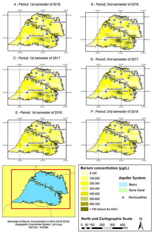
Figure 2
Estimate of Barium Concentration in BAS: A. 1st semester of 2016; B. 2st semester of 2016; C. 1st semester of 2017; D. 2st semester of 2017; E. 1st semester of 2018; F. 2st semester of 2018.
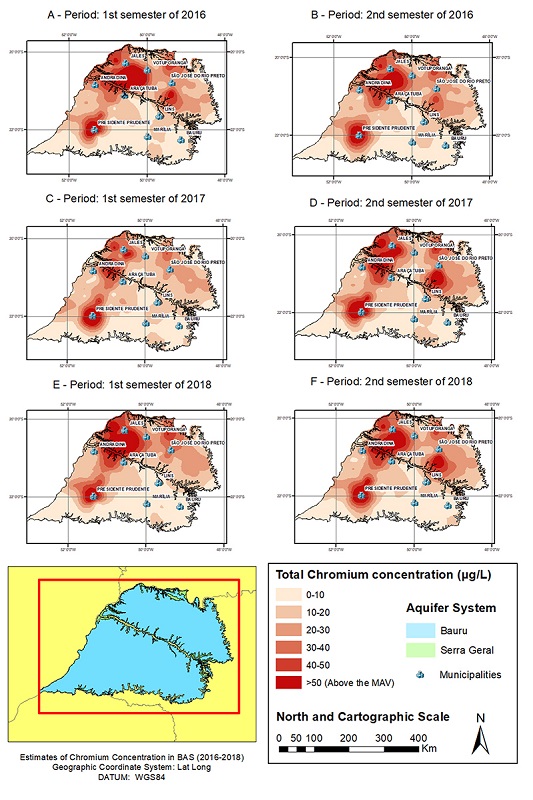
Figure 3
Estimate of Total Chromium concentration in BAS: A. 1st semester of 2016; B. 2st semester of 2016; C. 1st semester of 2017; D. 2st semester of 2017; E. 1st semester of 2018; F. 2st semester of 2018.
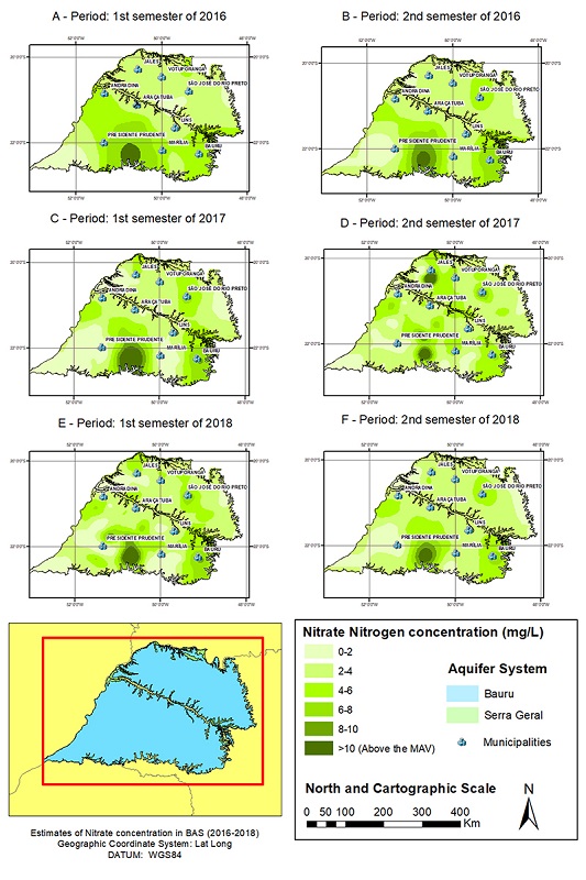
Figure 4
Estimate of Nitrate Concentration in BAS: A. 1st semester of 2016; B. 2st semester of 2016; C. 1st semester of 2017; D. 2st semester of 2017; E. 1st semester of 2018; F. 2st semester of 2018.
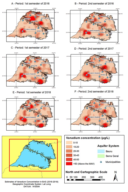
Figure 5
Estimate of Vanadium Concentration in BAS: A. 1st semester of 2016; B. 2st semester of 2016; C. 1st semester of 2017; D. 2st semester of 2017; E. 1st semester of 2018; F. 2st semester of 2018.
In order to analyze the relationship between the periods (years and semesters) and spatial variability of the chemical parameters, these data were plotted as shown in Figure 6. During the rainy season, the concentrations of these parameters tend to increase, as observed by Lima et al. (2020).
The temporal-spatial variation indicates that at the end of the rainy season (analyses made in the first semester of each year), the recharge of the aquifer via precipitation contributed to expand the areas where Cr, NO3- and Va concentrations exceeded MAV (Figure 6 and Figure 7).
As discussed by Lima et al. (2020), Cr and Va concentrations could have increased in function of the transport and/or dispersion of these elements. On the other hand, Ba concentrations increased during the dry season.
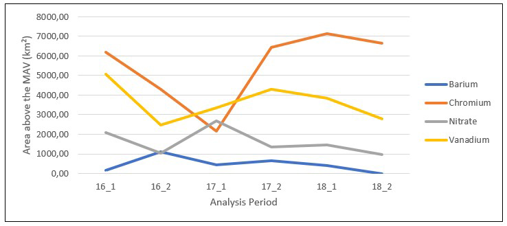
Figure 6
Estimated variation of the distribution of areas unsuitable for water consumption: concentrations of Ba, Cr, Ni and Va in BAS (2016-2018).
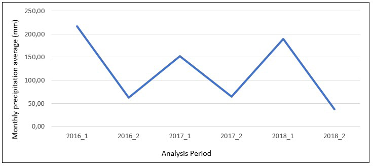
Figure 7
Average rainfall concentration in the BAS area per semester (2016-2018).
Source: SãoPaulo 2022
In a joint analysis of Figure 6 and Figure 7, we were able to perceive a directly proportional behavior related to the increase in areas of occurrence of NO3- with periods of higher rainfall averages. In this sense, this behavior may be related to diffuse sources of NO3- disposition in the aquatic environment, such as the transport of this element, often present in agricultural fertilizers (Zhao, Sun & Liu 2022), by the rain waters that promote the recharge of BAS in all its length due to its characteristics of free aquifer.
Another possible correlation would be the increase in areas with NO3- occurrence stemming from point insertions such as the direct disposal of contaminants with high organic load, such as domestic effluents or animal feedlot, thus NO3- may end up being dispersed in the environment as a result of its transport by recharging the BAS promoted by rainwater. This behavior is similar to that presented by Va, which may be present in groundwater both by natural form, due to weathering, and by anthropic forms due to its application in the industrial sector such as metallurgy, chemical industry, and battery production (Chiarelli et al. 2021; Scibior, Wnuk & Golebiowska 2021; Lee et al. 2021).
Ba is found naturally in the waters by leaching rocks with compounds such as barite, witherite and barry chloride, its presence is also associated with anthropic activities due to the use of this element in various segments such as mining, oil and gas exploration, plastics, glass, ceramics, electronics, textiles, metal alloys, rubbers, among other practices such as their application in the medical area as a contrast agent in radiographs (CETESB 2017; Poddalgoda et al. 2017).
According to Figures 6 and 7, we can see that the behavior of areas with Ba presence with values above the MAV is inverse to the increase in rainfall means. With this, we can associate the presence of Ba in the groundwater of the study area possibly with natural sources, where in periods with lower rainfall indices this element presents higher local concentration, and with the opposite situation, higher rainfall index and increased aquifer recharge, the concentrations of this element are diluted due to the increase in the volume of the water table.
The availability of Cr in the environment is associated with activities such as mining, metal processing, wood preservation, composition of paints and pigments, manufacture of refractories such as glass and ceramics, tanning, textile industry (Dhal et al. 2013) and natural processes such as the weathering of mafic and ultramafic rocks (Yan et al. 2021). The relationship between rainfall indices and areas with Cr above the MAV is not so clear since the element behaves outside a pattern both in the analyses performed after the dry period and for the analyses performed after the rainy season, and its concentration may not be directly affected by the climate regime, but by other factors. In addition, the largest spatial and time variations occurred in Cr concentrations (Table 4), for a more assertive analysis, it would be necessary to have a better understanding of the climatic regime in these regions of Cr occurrence above the MAV during the study periods, as well as the use and occupation of the soil and economic activities performed in these places.
Ba = Barium, Cr = Total Chromium, Ni = Nitrate, Va = Vanadium.
Figure 8 shows that some regions stand out for concentrations above MAV in all 2016-2018 semesters, such as the Presidente Prudente (total Cr and Va), the region between Marília and Presidente Prudente (Ni), and the region of Jales (total Cr). Lima et al. (2020) showed that the Presidente Prudente region was the most critical region within BAS during the 2013-2015 period.
The map of Figure 8 was integrated to the Groundwater Information System - SIAGAS databank (CPRM 2021), making it possible to obtain information about the wells (Figures 9 and 10). A total of 5,204 wells exploit the Bauru Aquifer System, of which 1,043 are in areas described as critical. São José do Rio Preto and Presidente Prudente are the municipalities with the highest numbers of wells, 158 and 143 respectively in critical areas (Figure 9).
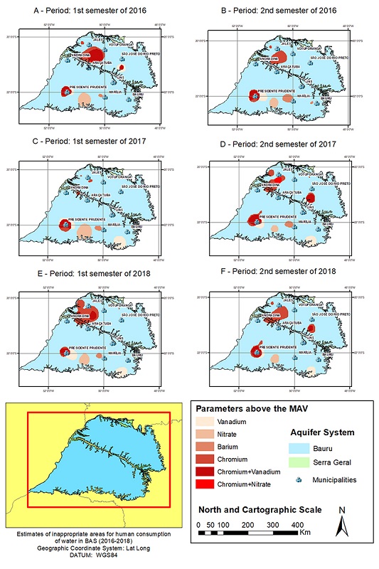
Figure 8
Estimation of BAS areas unfit for human water consumption (2016-2018): A. 1st semester of 2016; B. 2st semester of 2016; C. 1st semester of 2017; D. 2st semester of 2017; E. 1st semester of 2018; F. 2st semester of 2018.
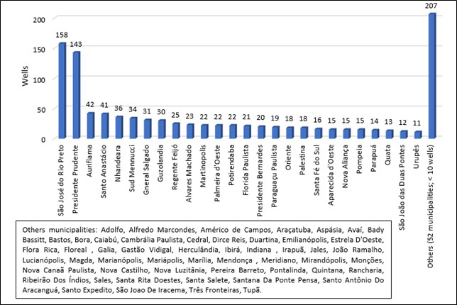
Figure 9
Graph with estimation of BAS areas unfit for human water consumption (2016-2018).
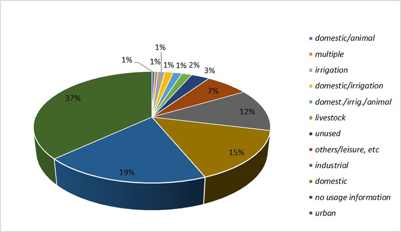
Majority of the wells were constructed for urban (385) and domestic (156) use, suggesting the water consumption (Figure 10). This information concerns only licensed wells. As mentioned before, other (not licensed) wells exist in BAS that may be exploiting water illegally.Source: CPRM 2021
This fact requires special attention from users and public managers in the sense that many of the parameters found with concentrations above permitted by law may cause harm to health and harm to the population. Vanadium, when ingested at high concentrations, can cause damage to blood cell DNA, damage to fetal development and change in neurobehavioral functions (Ehrlich et al. 2008; Li et al. 2013; Hu et al. 2018; Zwolak 2020), Chromium has carcinogenic content for humans (Akoto et al. 2021), Barium exposure may result in heart problems, muscle paralysis, respiratory failure, miscarriages, and fetal growth restriction (CETESB 2017; Pi et al. 2019), Nitrate may be responsible for diseases such as blue baby syndrome (Ransom et al. 2022).
3.4 Verification
Areas in BAS with Ba concentrations above MAV (Figure 8) intersect those presented by Lima et al. (2020) and with the occurrences observed in the 2010-2012 triennium (CETESB 2013). It is also noteworthy that most of the municipalities included in Figure 8 coincide with those reported by Rios et al. (2017). As mentioned earlier, these unusual Ba concentrations probably have a natural origin (Tavares et al. 2015). Other studies in different regions also point to high Ba concentrations in carbonate rocks (Moles 2015; Rddad & Bouhlel 2016; Dunning et al. 2018).
Areas in BAS with total Cr concentrations above (Figure 8) also intersect the areas presented by Lima et al. (2020). The kriging interpolation maps obtained in this study, when analyzed together with the data from Lemos et al. (2002) corroborate the fact that our results satisfactorily represent areas in BAS with high total Cr concentrations. The occurrence of high Cr concentrations in BAS can be associated with both natural and anthropic origins, as observed by Bertolo et al. (2011a) and Bertolo et al. (2011b). The anthropic origin can be explained by the fact that many tannery factories operate in Presidente Prudente nowadays (Souza et al. 2019). Tannery effluents are common Cr sources, but they are unusually treated or monitored (Campos 2003; Pacheco 2010; Wagh et al. 2018).
The areas with NO3- concentrations above MAV (Figure 8) correspond to those of the 2010-2012 and 2013-2015 periods (CETESB 2013, 2016). Vicente, Lima and Marques (2018) reported NO3- concentrations above MAV only in the Andradina region. This indicates that the spatial distribution of improper NO3- concentrations vary in BAS. According to Stradioto et al. (2019), the highest NO3- concentrations occur in regions of leaking sewage, waste disposal, and in older parts of urban areas with greater concentrations of septic tanks.
The areas with Va concentrations above MAV (Figure 8) also intersect with the areas presented by Lima et al. (2020). However, an increase of these areas is observed, when our results are compared to those of Lima et al. (2020). Wright and Belitz (2010) point out that, despite potential sources of Va to groundwater include dissolution of Va rich rocks and waste streams from industrial processes, the high Va concentrations in groundwater samples collected in California were almost always associated with oxidizing and alkaline groundwater conditions.
The maps produced in the present study are extremely important for society, since their use can be applied in several follow-ups. The private sector can have the information obtained to assist in the strategic locational planning according to the quality of the water applied to their specific productive needs. For the government and regulatory bodies, for example, maps are an extremely useful tool for regulating the exploitation of groundwater as well as the releases and use and occupation of the soil in the region according to the quality of the water and the spatialization of the parameters through geostatistics. This way, a forecast of water quality is obtained even for sites not sampled in an economically viable way, with low costs involved making groundwater planning and management more assertive, being able to provide the best places for drilling new wells or the most favorable treatment for those already in activity, just as the appropriate assessment of the granting of use.
4 Conclusions
The water-quality parameters treated using kriging methods helped delimit critical areas for water use in the 2016, 2017 and 2018 semesters. Total Cr and Va had the critical areas. Except for Ba, the spatial distributions of the parameter concentrations indicated that during the rainy season the critical areas increase, while in the dry season they are reduced. The Ba, Cr and Va concentrations above MAV seem to be primarily related to natural factors, while NO3 concentrations are related to anthropic actions. Public managers may plan actions to decrease these concentrations so the users do not suffer the consequences of improper consumption.
5 References
Akoto, O., Adopler, A., Tepkor, H.E. & Opoku, F. 2021, 'A comprehensive evaluation of surface water quality and potential health risk assessments of Sisa river, Kumasi', Groundwater for Sustainable Development, vol. 15, 100654, DOI:10.1016/j.gsd.2021.100654.
Bertolo, R., Bourotte, C., Hirata, R., Marcolan, L. & Sracek, O. 2011a, 'Geochemistry of natural chromium occurrence in a sandstone aquifer in Bauru Basin, state of São Paulo, Brazil', Applied Geochemistry, vol. 26, no. 8, pp. 1353-63, DOI:10.1016/j.apgeochem.2011.05.009.
Bertolo, R., Bourotte, C., Marcolan, L., Oliveira, S. & Hirata, R. 2011b, 'Anomalous content of chromium in a Cretaceous sandstone aquifer of the Bauru Basin, state of São Paulo, Brazil', Journal of South American Earth Sciences, vol 31, no. 1, pp. 69-80, DOI:10.1016/j.jsames.2010.10.002.
4. Bertolo, R., Hirata, R. & Aly Junior, O. 2019, 'Método de valoração da água subterrânea impactada por atividades contaminantes no Estado de São Paulo', Águas Subterrâneas, vol. 33, no. 3, pp. 303-13, DOI:10.14295/ras.v33i3.29479.
Brasil 2021, Portaria GS/MS n° 888, de 04 de maio de 2021, Diário Oficial da União, viewed 13 May 2022, <Brasil 2021, Portaria GS/MS n° 888, de 04 de maio de 2021, Diário Oficial da União, viewed 13 May 2022, https://www.in.gov.br/en/web/dou/-/portaria-gm/ms-n-888-de-4-de-maio-de-2021-318461562>.
Brasil 2011, Portaria n° 2.914, de 12 de dezembro de 2011, Ministério da Saúde, viewed 13 May 2022, <914, de 12 de dezembro de 2011, Ministério da Saúde, viewed 13 May 2022, https://bvsms.saude.gov.br/bvs/saudelegis/gm/2011/prt2914_12_12_2011.html>.
Brasil 2008, Resolução CONAMA n° 396, de 3 de abril de 2008, Diário Oficial da União, viewed 21 May 2022, <Brasil 2008, Resolução CONAMA n° 396, de 3 de abril de 2008, Diário Oficial da União, viewed 21 May 2022, https://tinyurl.com/mr2hnc3b>.
Camara, G., Souza, R.C.M., Freitas, U.M. & Garrido, J. 1996, 'SPRING: Integrating remote sensing and GIS by object-oriented data modelling', Computers & Graphics, vol. 20, no. 3, p. 395-403, DOI:10.1016/0097-8493(96)00008-8.
Campos, F.H. 2003, 'A Indústria de curtimento de couro em Presidente Prudente: a relação sociedade-natureza em questão', Master Thesis, Universidade Estadual Paulista, São Paulo, viewed 21 May 2022, < 2003, 'A Indústria de curtimento de couro em Presidente Prudente: a relação sociedade-natureza em questão', Master Thesis, Universidade Estadual Paulista, São Paulo, viewed 21 May 2022, http://hdl.handle.net/11449/92846>.
Canato, H.M., Conceição, F.T., Hamada, J., Moruzzi, R. & Navarro, G.R.B. 2014, 'Caracterização hidrogeoquímica do aquífero adamantina na área urbana de Bauru, SP', Science & Engineering Journal, vol. 23, no. 2, pp. 39-47, DOI:10.14393/19834071.2014.24758.
Carvalho, L.L.S., Lacerda, C.F., Carvalho, C.M., Lopes, F.B., Andrade, E.M. & Gomes Filho, R.R. 2020, 'Spatio-temporal variability of groundwater quality in na irrigated área in the brazilian semiarid region', Research, Society and Development, vol. 9, no. 8, e644985786, DOI:10.33448/rsd-v9i8.5786.
CETESB ‒ Companhia Ambiental do Estado de São Paulo 2013, Qualidade das águas subterrâneas no Estado de São Paulo 2010-2012, viewed 21 May 2022, <CETESB ‒ Companhia Ambiental do Estado de São Paulo 2013, Qualidade das águas subterrâneas no Estado de São Paulo 2010-2012, viewed 21 May 2022, https://cetesb.sp.gov.br/aguas-subterraneas/publicacoes-e-relatorios/>.
CETESB ‒ Companhia Ambiental do Estado de São Paulo 2016, Qualidade das águas subterrâneas no Estado de São Paulo 2013-2015, viewed 13 May 2022, <CETESB ‒ Companhia Ambiental do Estado de São Paulo 2016, Qualidade das águas subterrâneas no Estado de São Paulo 2013-2015, viewed 13 May 2022, https://cetesb.sp.gov.br/aguas-subterraneas/publicacoes-e-relatorios/>.
CETESB ‒ Companhia Ambiental do Estado de São Paulo 2017, Ficha de Informações toxicológicas [Bário], Cetesb, São Paulo, viewd 13 Nov 2021, <CETESB ‒ Companhia Ambiental do Estado de São Paulo 2017, Ficha de Informações toxicológicas [Bário], Cetesb, São Paulo, viewd 13 Nov 2021, https://cetesb.sp.gov.br/laboratorios/wp-content/uploads/sites/24/2022/02/Bario.pdf>.
CETESB ‒ Companhia Ambiental do Estado de São Paulo 2019, Qualidade das águas subterrâneas no Estado de São Paulo 2016-2018, Cetesb, São Paulo , viewed 21 May 2022, <CETESB ‒ Companhia Ambiental do Estado de São Paulo 2019, Qualidade das águas subterrâneas no Estado de São Paulo 2016-2018, Cetesb, São Paulo , viewed 21 May 2022, https://cetesb.sp.gov.br/aguas-subterraneas/publicacoes-e-relatorios/>.
Chiarelli, R., Martino, C., Roccheri, M.C. & Cancemi, P. 2021, 'Toxic effects induced by vanadium on sea urchin embryos', Chemosphere, vol. 274, 129843, DOI:10.1016/j.chemosphere.2021.129843.
Coraça, A.L.S. & Helene, L.P.I. 2021, 'Determinação da vulnerabilidade natural do Aquífero Bauru na Bacia Hidrográfica do Rio Itaquerê', Revista Águas Subterrâneas, vol. 35, no. 3, pp. 1-12, DOI:10.14295/ras.v35i3.30113.
Coyte, R.M. & Vengosh, A. 2020, 'Factors controlling the risk of co-occurrence of the redox-sensitive elements of arsenic, chromium, vanadium and uranium in groundwater from the Eastern United States', Environmental Science & Technology, vol. 54, no. 7, pp. 4367-75, DOI:10.1021/acs.est.9b06471.
CPRM ‒ Companhia de Pesquisa de Recursos Minerais 2021, SIAGAS - Sistema de Informações de Águas Subterrâneas (SIAGASWEB), viewed 21 May 2022, <CPRM ‒ Companhia de Pesquisa de Recursos Minerais 2021, SIAGAS - Sistema de Informações de Águas Subterrâneas (SIAGASWEB), viewed 21 May 2022, https://tinyurl.com/uchk32vy>.
Cressie, N.A.C. 1991, Statistics for spatial data, John Wiley & Sons, New York.
Dhal, B., Thatoi, H.N., Das, N.N., Pandey, B.D. 2013, 'Chemical and microbial remediation of hexavalent chromium from contaminated soil and mining/metallurgical solid waste: a review', Journal of Hazardous Materials, vol. 250-251, pp. 272-91, DOI:10.1016/j.jhazmat.2013.01.048.
Drias, T., Khedidja, A., Belloula, M., Badraddine, S. & Saibi, H. 2020, 'Groundwater modelling of the Tebessa-Morsott alluvial aquifer (northeastern Algeria): a geostatistical approach', Groundwater for Sustainable Development, vol. 11, 100444, DOI:10.1016/j.gsd.2020.100444.
Dunning, G., Walstrom, R.E. & Lechner, W. 2018, 'Barium silicate mineralogy of the western margin, North American Continent, Part 1: geology, origin, paragenesis and mineral distribution from Baja California Norte, Mexico, Western Canada and Alaska, USA', Baymin Journal, vol. 19, no. 5, pp. 1-70, viewed 21 May 2022, < 1-70, viewed 21 May 2022, https://tinyurl.com/4umww34v>.
Ehrlich, V.A., Nersesyan, A.K., Hoelzl, C., Ferk, F., Bichler, J., Valic, E., Schaffer, A., Schulte-Hermann, R., Fenech, M., Karl-Heinz, W. & Knasmüller, S. 2008, 'Inhalative exposure to vanadium pentoxide causes DNA damage in workers: results of a multiple end point study', Environmental Health Perspectives, vol. 116, no. 12, pp. 1689-93, DOI:10.1289/ehp.11438.
ESRI ‒ Environmental Systems Research Institute 2013, ArcGIS for Desktop - ArcMap, Version 10.3, viewed 21 May 2022, <3, viewed 21 May 2022, https://www.esri.com/pt-br/arcgis/products/index>.
Fatola, O.I., Olaolorun, F.A., Olopade, F.E. & Olopade, J.O. 2018, 'Trends in vanadium neurotoxicity', Brain Research Bulletin, vol. 145, pp. 75-80, DOI:10.1016/j.brainresbull.2018.03.010.
Garpelli, L.N. & Gastmans, D. 2020, 'Potencial hidromineral dos aquíferos do estado de São Paulo', Pesquisas em Geociências, vol. 47, no. 3, e100458, DOI:10.22456/1807-9806.109987.
Hirata, R.C.A., Suhogusoff, A., Marcellini, S.S., Villar, P.C. & Marcellini, L. 2019, As águas subterrâneas e sua importância ambiental e socioeconômica para o Brasil, Instituto de Geociências, Universidade de São Paulo, São Paulo, DOI:10.11606/9788563124074.
Hu, J., Peng, Y., Zheng, T., Zhang, B., Liu, W., Wu, C., Jiang, M., Braun, J.M., Liu, S., Buka, S.L., Zhou, A., Wise, J.P., Zhang, Y., Jiang, Y., Hu, C., Chen, X., Huang, Z., Zheng, D., Shi, K., Zhang, X., Truong, A., Qian, Z., Xia, W., Li, Y. & Xu, S. 2018, 'Effects of trimester-specific exposure to vanadium on ultrasound measures of fetal growth and birth size: a longitudinal prospective prenatal cohort study', The Lancet Planetary Health, vol. 2, no. 1, pp. 427-37, DOI:10.1016/S2542-5196(18)30210-9.
Iritani, M.A. & Ezaki, S. 2012, As águas subterrâneas do Estado de São Paulo, Secretaria de Estado do Meio Ambiente - SMA, Instituto Geológico, São Paulo, viewed 21 May 2022, < 2012, As águas subterrâneas do Estado de São Paulo, Secretaria de Estado do Meio Ambiente - SMA, Instituto Geológico, São Paulo, viewed 21 May 2022, http://twixar.me/FyRm>.
Isaaks, E.H. & Srivastava, R.M. 1989, Applied geostatistics, Oxford University Press, Nova York.
Joodavi, A., Aghlmand, R., Podgorski, J., Dehbandi, R. & Abbasi, A. 2021, 'Characterization, geostatistical modeling and health risk assessment of potentially toxic elements in groundwater resources of northeastern Iran', Journal of Hydrology: Regional Studies, vol. 37, 100885, DOI:10.1016/j.ejrh.2021.100885.
Kiang, C.H., Stradioto, M.R. & Silva, F.P. 2016, 'Tipos hidroquímicos do Sistema aquífero Bauru no Estado de São Paulo', Águas Subterrâneas, vol. 30, no. 2, pp. 224-45, DOI:10.14295/ras.v30i2.28005.
Lee, J.-C., Kim, E., Chung, K.-W., Kim, R. & Jeon, H.-S. 2021, 'A review on the metallurgical recycling of vanadium from slags: towards a sustainable vanadium production', Journal of Materials Research and Technology, vol. 12, pp. 343-64, DOI:10.1016/j.jmrt.2021.02.065.
Lemos, M.M.G., Silva, M.F.B., Dias, C.L., Bucci, E.M. & Casarini, D.P. 2002, 'Qualidade das águas subterrâneas no estado de São Paulo, em poços tubulares utilizados para abastecimento público', XII Congresso Brasileiro de Águas Subterrâneas, viewed 21 May 2022, < 2002, 'Qualidade das águas subterrâneas no estado de São Paulo, em poços tubulares utilizados para abastecimento público', XII Congresso Brasileiro de Águas Subterrâneas, viewed 21 May 2022, https://tinyurl.com/3b69npm6>.
Li, H., Zhou, D., Zhang, Q., Feng, C., Zheng, W., He, K. & Lan, Y. 2013, 'Vanadium exposure-induced neurobehavioral alterations among Chinese workers', NeuroToxicology, vol. 36, pp. 49-54, DOI:10.1016/j.neuro.2013.02.008.
37. Lima, C.G.R., Lollo, J.A., Bacani, V.M. & Costa, N.R. 2020, 'Variabilidade espaçotemporal das águas subterrâneas do aquífero Bauru impróprias para o consumo humano: concentrações de Bário, Crômio Total e Vanádio', Pesquisas em Geociências, vol. 47, no. 2, e096380, DOI:10.22456/1807-9806.108582.
Liu, J., Gao, Z., Zhang, Y., Sun, Z., Sun, T., Fan, H., Wu, B., Li, M. & Qian, L. 2021, 'Hydrochemical evaluation of groundwater quality and human health risk assessment of nitrate in the largest peninsula of China based on high-density sampling: a case study of Weifang', Journal of Cleaner Production, vol. 322, 129164, DOI:10.1016/j.jclepro.2021.129164.
Lourencetti, J., Felizardo, L.M., Faria, G.M., Prates, M.M. & Oliveira, J.N. 2020, 'Uma Comparison of overexploitation of Bauru Aquifer in the years 2002 and 2012', Research, Society and Development, vol. 9, no. 10, e8479109176, DOI:10.33448/rsd-v9i10.9176.
Lundgren, W.J.C., Silva, J.A.A. & Ferreira, R.L.C. 2017, 'A precisão da estimativa do erro da krigagem pela validação cruzada', Floresta e Ambiente, vol. 24, e00124114, DOI:10.1590/2179-8087.124114.
Manzione, R.L. & Castrignaro, A. 2019, 'A geostatistical approach for multi-source data fusion to predict water table depth', Science of The Total Environment, vol. 696, 133763, DOI:10.1016/j.scitotenv.2019.133763.
Manzione, R.L., Silva, C.O.F. & Castrignaro, A. 2020, 'A combined geostatistical approach of data fusion and stochastic simulation for probabilistic assessment of shallow water table depth risk', Science of The Total Environment, vol. 765, 142743, DOI:10.1016/j.scitotenv.2020.142743.
Marques, C.H.G., Terada, R., Galvão, P. & Hirata, R. 2019, 'Evolução espacial e temporal da contaminação por nitrato no aquífero urbano de Urânia (SP)', Águas Subterrâneas, vol. 33, no. 3, pp. 258-69, DOI:10.14295/ras.v33i3.29524.
Mataveli, L.R.V., Buzzo, M.L., Carvalho, M.F.H., Arauz, L.J. & Mataveli, G.A.V. 2018, 'Avaliação dos níveis de cromo total em águas para consumo humano', Revista do Instituto Adolfo Lutz, vol. 77, e1748, DOI:10.53393/rial.2018.v77.34184.
Moles, N.R. 2015, 'Barium carbonates as relict of chemical sediments diagenesis in the Alberfedy stratiforme barite deposits, Grampian Highlands, Scotland', 13th Biennial SGA Meeting, Nancy, France, viewed 9 May 2022, < 2015, 'Barium carbonates as relict of chemical sediments diagenesis in the Alberfedy stratiforme barite deposits, Grampian Highlands, Scotland', 13th Biennial SGA Meeting, Nancy, France, viewed 9 May 2022, https://tinyurl.com/2p9af4t9>.
46. Montanheiro, F. & Chang, H.K. 2016, 'Nitrato no Aquífero Adamantina: o caso do município de Monte Azul Paulista, SP', Revista do Instituto Geológico, vol. 37, no. 2, pp. 25-44, DOI:10.5935/0100-929X.20160007.
47. Nunes, M.A., Aravena, R. & Parker, B.L. 2021, 'Geochemical and isotopic evidence for pumping-induced impacts to bedrock groundwater quality in the City of Guelph, Canada', Science of The Total Environment, vol. 800, 149359, DOI:10.1016/j.scitotenv.2021.149359.
Oliveira, F.L.V., Kuno, R., Nascimento, F.P. & Gouveira, N. 2021, 'Exposição potencial a baixas doses de cromo por via oral e mortalidade por câncer de estômago na população do interior do Estado de São Paulo, Brasil', Cadernos de Saúde Pública, vol. 37, no. 4, e00020020, DOI:10.1590/0102-311X00020020.
Osiakwan, G.M, Appiah-Adjei, E.K., Kabo-Bah, A.T., Gibrilla, A. & Anornu, G. 2021, 'Assessment of groundwater quality and the controlling factors in coastal aquifers of Ghana: an integrated statistical, geostatistical and hydrogeochemical approach', Journal of African Earth Sciences, vol. 184, 104371, DOI:10.1016/j.jafrearsci.2021.104371.
Pacheco, J.W.F. 2010, 'Gestão de água na indústria de curtumes do estado de São Paulo - Um diagnóstico sob os princípios da produção mais limpa', Master Thesis, Centro Estadual de Educação Tecnológica Paula Souza, São Paulo, viewed 21 May 2022, < 2010, 'Gestão de água na indústria de curtumes do estado de São Paulo - Um diagnóstico sob os princípios da produção mais limpa', Master Thesis, Centro Estadual de Educação Tecnológica Paula Souza, São Paulo, viewed 21 May 2022, https://tinyurl.com/3fuatfub>.
Pi, X., Jin, L., Li, Z., Zhang, Y., Wang, L. & Ren, A. 2019, 'Association between concentrations of barium and aluminum in placental tissues and risk for orofacial clefts', Science of The Total Environment, vol. 652, pp. 406-12, DOI:10.1016/j.scitotenv.2018.10.262.
Pimentel-Gomes, F. & Garcia, C.H. 2001, 'Estatística aplicada a experimentos agronômicos e florestais', Revista Agricultura, vol. 76, no. 3, 476, DOI:10.37856/bja.v76i3.1314.
53. Poddalgoda, D., Macey, K., Assad, H. & Krishnan, K. 2017, 'Development of biomonitoring equivalents for barium in urine and plasma for interpreting human biomonitoring data', Regulatory Toxicology and Pharmacology, vol. 86, pp. 303-11, DOI:10.1016/j.yrtph.2017.03.022.
Qureshi, S.S., Channa, A., Memon, S.A., Khan, Q., Jamali, G. A., Panhwar, A. & Saleh, T.A. 2021, 'Assessment of physicochemical characteristics in groundwater quality parameters', Environmental Technology & Innovation, vol. 24, 101877, DOI:10.1016/j.eti.2021.101877.
Ransom, K.M., Nolan, B.T., Stackelberg, P.E., Belitz, K. & Fram, M.S. 2022, 'Machine learning predictions of nitrate in groundwater used for drinking supply in the conterminous United States', Science of The Total Environment, vol. 807, no. 3, 151065, DOI:10.1016/j.scitotenv.2021.151065.
Rashid, A., Ayub, M., Javed, A., Khan, S., Gao, X., Li, C., Ullah, Z., Sardar, T., Muhammad, J. & Nazneen, S. 2021, 'Potentially harmful metals, and health risk evaluation in groundwater of Mardan, Pakistan: application of geostatistical approach and geographic information system', Geoscience Frontiers, vol. 12, no. 3, 101128, DOI:10.1016/j.gsf.2020.12.009.
Rddad, L. & Bouhlel, S. 2016, 'The Bou Dahar Jurassic carbonate-hosted Pb-Zn-Ba deposits (Oriental High Atlas, Morocco): fluid-inclusion and C-O-S-Pb isotopes studies', Ore Geology Reviews, vol. 72, no. 1, pp. 1072-87, DOI:10.1016/j.oregeorev.2015.08.011.
Rios, A.P., Tavares, T., Correa, N., Ferreira, A.L., Cavani, A.C.M., Martins, V., Crespi, A., Bertolo, R., Carvalho, A.M., Albuquerque Filho, J.L. & Cândido, S. 2017, 'Caracterização hidroquímica do sistema aquífero Bauru no espigão de Marília (SP)', XIX Congresso Brasileiro de Águas Subterrâneas, viewed 21 May 2022, < 2017, 'Caracterização hidroquímica do sistema aquífero Bauru no espigão de Marília (SP)', XIX Congresso Brasileiro de Águas Subterrâneas, viewed 21 May 2022, https://doi.org/10.14295/ras.v0i0.28725>.
Robertson, G.P. 2004, GS+: Geoestatistics for the environmental sciences (GS+ User´s Guide), Gamma Desing Software, Plainwell, Michigan.
Romagnoli, I. & Manzione, R.L . 2018, 'Mapeamento da vulnerabilidade das águas subterrâneas e riscos de contaminação na região do Pontal do Paranapanema (UGRHI - 22)', Brazilian Journal of Biosystems Engineering, vol. 12, no. 3, pp. 307-26, DOI:10.18011/bioeng2018v12n3p307-326.
Rosenberger, M., Varnier, C., Iritani, M.A., Ferreira, L.M.R., Oda, G.H. & Viotti, M. 2013, 'Vulnerabilidade natural à contaminação do Sistema Aquífero Bauru na área urbana do município de Bauru (SP)', Revista do Instituto Geológico, vol. 34, no. 3, pp. 51-67, DOI:10.5935/0100-929X.20130009.
São Paulo 2005, DAEE ‒ Departamento de Águas e Energia Elétrica; IG ‒ Instituto Geológico; IPT ‒ Instituto de Pesquisas Tecnológicas do Estado de São Paulo; CPRM ‒ Serviço Geológico do Brasil, Mapa de águas subterrâneas do Estado de São Paulo escala 1:1.000.000, viewed 21 May 2022, <000, viewed 21 May 2022, https://tinyurl.com/hx4vr9es>.
São Paulo 2011, DAEE ‒ Departamento de Águas e Energia Elétrica; IG ‒ Instituto Geológico, Projeto São José do Rio Preto: restrição e controle de uso de água subterrânea, viewed 21 May 2022, <São Paulo 2011, DAEE ‒ Departamento de Águas e Energia Elétrica; IG ‒ Instituto Geológico, Projeto São José do Rio Preto: restrição e controle de uso de água subterrânea, viewed 21 May 2022, https://tinyurl.com/ye4y2arn>.
São Paulo 2022, DAEE - Departamento de Águas e Energia Elétrica, Banco de Dados Hidrológico, viewed 21 May 2022, <São Paulo 2022, DAEE - Departamento de Águas e Energia Elétrica, Banco de Dados Hidrológico, viewed 21 May 2022, http://www.hidrologia.daee.sp.gov.br>.
Scibior, A., Wnuk, E. & Golebiowska, D. 2021, 'Wild animals in studies on vanadium bioaccumulation - Potential animal models of environmental vanadium contamination: A comprehensive overview with a Polish accent', Science of The Total Environment, vol. 785, 147205, DOI:10.1016/j.scitotenv.2021.147205.
Siste, N.A. & Souza, A.T.A. 2013, 'A qualidade da água das minas utilizadas para fins de potabilidade em pontos de afloramento do aquífero Bauru no entorno de Presidente Prudente/SP', Colloquium Exactarum, vol. 5, no. esp, pp. 141-8, DOI:10.5747/ce.2013.v05.nesp.000064.
Solgi, E. & Jalili, M. 2021, 'Zoning and human health risk assessment of arsenic and nitrate contamination in groundwater of agricultural areas of the twenty two village with geostatistics (Case study: Chahardoli Plain of Qorveh, Kurdistan Province, Iran)', Agricultural Water Management, vol. 255, 107023, DOI:10.1016/j.agwat.2021.107023.
Souza, W.V.F., Teixeira, M.C., Cruz, T.S., Silva, F.P., Silva, K.V.C. & Costa, G.K.V. 2019, 'Impactos socioambientais: uma leitura a partir dos processos de urbanização e da indústria coureria em Presidente Prudente (SP)', Revista Geografia em Atos, vol. 7, no. 14, pp. 163-80, DOI:10.35416/geoatos.v7i14.666.
Stradioto, M.R., Teramoto, E.H. & Chang, H.K. 2019, 'Nitrato em águas subterrâneas do Estado de São Paulo', Revista do Instituto Geológico, vol. 40, no. 3, pp. 1-12, DOI:10.33958/revig.v40i3.672.
Tavares, T., Bertolo, R., Fiúme, B., Crespi, A., Martins, V. & Hirata, R. 2015, 'Hydrochemical investigation of barium in the public water supply wells of Sao Paulo state, southern Brazil ', Environmental Earth Sciences, vol. 74, no. 9, pp. 6599-612, DOI:10.1007/s12665-015-4661-7.
Uddin, M.G., Moniruzzaman, M., Quader, M.A. & Hasan, M.A. 2018, 'Spatial variability in the distribution of trace metals in groundwater around the Rooppur nuclear power plant in Ishwardi, Bangladesh', Groundwater for Sustainable Development, vol. 7, pp. 220-31, DOI:10.1016/j.gsd.2018.06.002.
Vicente, G.Z., Lima, C.G.R. & Marques, S.M. 2018, 'Variabilidade espacial e temporal do Nitrato e Cloreto no Sistema Aquífero Bauru, estado de São Paulo', Águas Subterrâneas, vol. 32, no. 3, pp. 295-306, DOI:10.14295/ras.v32i3.29099.
Villar, P.C. 2016, 'Groundwater and the right to water in a contexto of crisis', Ambiente & Sociedade, vol. 14, no. 1, pp. 83-102, DOI:10.1590/1809-4422ASOC150126R1V1912016.
Vinson, D.S., Vail Meador, J., Batianis, E., Gazel, E., Polizzoto, M. & Duckworth, O. 2019, 'Naturally occurring groundwater chromium and vanadium in piedmont saprolite and fractured crystalline rocks: relationship between redox-sensitive solutes and trace element speciation', GSA Annual Meeting in Phoenix, Arizona , viewed 21 May 2022, < 2019, 'Naturally occurring groundwater chromium and vanadium in piedmont saprolite and fractured crystalline rocks: relationship between redox-sensitive solutes and trace element speciation', GSA Annual Meeting in Phoenix, Arizona , viewed 21 May 2022, https://gsa.confex.com/gsa/2019AM/webprogram/Paper337866.html>.
Wagh, V.M., Panaskar, D.B., Mukate, S.V., Gaikwad, S.K., Muley, A.A. & Varade, A.M. 2018, 'Health risk assessment of heavy metal contamination in groundwater of Kadana River Basin, Nashik, India', Modeling Earth Systems and Environment, vol. 4, no. 3, pp. 969-80, DOI:10.1007/s40808-018-0496-z.
Wang, L., Stuart, M.E., Lewis, M.A., Ward, R.S., Skirvin, D., Naden, P.S., Collins, A.L. & Ascott, M.J. 2016, 'The changing trend in nitrate concentrations in major aquifers due to historical nitrate loading from agricultural land across England and Wales from 1925 to 2150', Science of The Total Environment, vol. 542, no. A, pp. 694-705, DOI:10.1016/j.scitotenv.2015.10.127.
WHO ‒ World Health Organization 2000, Air quality guidelines - Vanadium, 2nd edn, WHO, Copenhagen.
WHO ‒ World Health Organization 2011, Guidelines for drinking-water quality, 4th edn, WHO, Genebra.
Wright, M.T. & Belitz, K. 2010, 'Factors controlling the regional distribution of vanadium in groundwater', Ground Water, vol. 48, no. 4., pp. 515-25, DOI:10.1111/j.1745-6584.2009.00666.x.
Yamamoto, J.K. & Landim, P.M.B. 2013, Geoestatística: conceitos e aplicações, Editora Oficina de Letras, São Paulo.
Yan, T., Wang, X., Liu, D., Chi, Q., Zhou, J., Xu, S., Zhang, B., Nie, L. & Wang, L. 2021, 'Continental-scale spatial distribution of chromium (Cr) in China and its relationship with ultramafic-mafic rocks and ophiolitic chromite deposit', Applied Geochemistry, vol. 126, 104896, DOI:10.1016/j.apgeochem.2021.104896.
Zhao, B., Sun, Z. & Liu, Y. 2022, 'An overview of in-situ remediation for nitrate in groundwater', Science of The Total Environment, vol. 804, 149981, DOI:10.1016/j.scitotenv.2021.149981.
Zwolak, I. 2020, 'Protective effects of dietary antioxidants against vanadium-induced toxicity: a review', Oxidative Medicine and Cellular Longevity, vol. 2020, 1490316, DOI:10.1155/2020/1490316.
Data availability statement
Funding information
Author notes
E-mail: isadora.vitali@unesp.brE-mail: olavo.tercini@unesp.brE-mail: jose.lollo@unesp.brE-mail: cesar.lima@unesp.br
Conflict of interest declaration