Article
Water and Geological Assessment in the Micro-Watersheds of the Alkaline Rocks of Tanguá and Soarinho in Rio de Janeiro State
Avaliação Hídrica e Geológica nas Microbacias dos Maciços Alcalinos de Tanguá e Soarinho no Estado do Rio de Janeiro
 Marcos Caldeira de Barros marcos_cbarros@hotmail.com
Anderson Costa dos Santos andcostasantos@gmail.com
Mônica de Aquino Galeano Massera da Hora monicahora@id.uff.br
Marcelo dos Santos Salomão salomao.mss@gmail.com
Antonio Ferreira da Hora antoniohora@id.uff.br
Marco Aurélio Maia Teodoro marcomaia.geo@hotmail.com
Marcos Caldeira de Barros marcos_cbarros@hotmail.com
Anderson Costa dos Santos andcostasantos@gmail.com
Mônica de Aquino Galeano Massera da Hora monicahora@id.uff.br
Marcelo dos Santos Salomão salomao.mss@gmail.com
Antonio Ferreira da Hora antoniohora@id.uff.br
Marco Aurélio Maia Teodoro marcomaia.geo@hotmail.com
Water and Geological Assessment in the Micro-Watersheds of the Alkaline Rocks of Tanguá and Soarinho in Rio de Janeiro State
Anuário do Instituto de Geociências, vol. 46, 55780, 2023
Universidade Federal do Rio de Janeiro
Received: 25 November 2022
Accepted: 22 January 2023
Funding
Funding source: JCNE FAPERJ
Funding source: Projeto Emergentes 2019 FAPERJ
Contract number: E-26/201.469/2022
Contract number: E-26/010.002147/2019
Funding statement: 1) JCNE FAPERJ - Petrogênese do vulcanismo offshore brasileiro - Um estudo comparativo no Oceano Atlântico. E-26/201.469/2022 2) Projeto Emergentes 2019 FAPERJ - Potencial econômico dos maciços alcalinos do Rio de Janeiro - Subtítulo: Análise vulcanológica da Província Magmática Serra do Mar e um estudo comparativo do maciço Norte Patagônia do Complexo Somuncurá: impactos do potencial mineral. E-26/010.002147/2019
Abstract: Alkaline bodies of Tanguá and Soarinho in Rio de Janeiro present drainage areas that form the sources of the Soarinho and Caceribu Rivers. Due to its water and geological importance, we sought to investigate the relation between alkaline rocks and water bodies and the possible consequences of mining activity, as well as the use and occupation of land in water quality. Initially, the magnetometric profile was traced to confirm whether the locations selected for sample collection were located in the alkaline region. Then, water and sediment collections were carried out from the bed at three points on the Soarinho River and one point on the Caceribu River, all inserted in the drainages of the Soarinho and Tanguá alkaline massifs. Parameters necessary to calculate the Water Quality Index (WQI) and those related to contamination by mining activities were analyzed. Chemical analysis of the bed material sought to identify the deposition of contaminants. The context of alkaline rock interaction and water influence is confirmed through geophysical and lithogeochemical techniques through location maps and comparative results of bed material and direct samples of alkaline rocks that showed similar constitutions. In general, the WQI presented a median result, meeting the main requirements for appropriate water for conventional treatment aimed at public supply, and no indicators of contamination by mining activities were found, however, at point P3, representative of the headwaters of the Soarinho River, there were significant changes in BOD and fecal coliforms indicating direct discharge of domestic sewage in a nearby location. The results of the analyzes downstream of this point demonstrate the water bodies dilution capacity.
Keywords: Water quality, WQI, Mining activity.
Resumo: Os corpos alcalinos de Tanguá e Soarinho, no estado do Rio de Janeiro, apresentam áreas de drenagens que formam as nascentes dos rios Soarinho e Caceribu. Devido a sua importância hídrica e geológica, buscou-se investigar a relação entre as rochas alcalinas e corpos hídricos e as possíveis consequências da atividade de mineração, bem como o uso e ocupação do solo na qualidade da água. Inicialmente, foi traçado o perfil magnetométrico para confirmar se os locais selecionados para coleta das amostras estavam inseridos na região alcalina. Em seguida, foram realizadas coletas de água e de sedimentos do leito em três pontos do rio Soarinho e em um ponto do rio Caceribu, todos inseridos nas drenagens dos maciços alcalinos de Soarinho e Tanguá. Os parâmetros necessários ao cálculo do Índice de Qualidade da Água (IQA), bem como os relacionados às contaminações por atividades de mineração, foram analisados. A análise química do material do leito buscou identificar a deposição de contaminantes. O contexto de interação rocha alcalina e influência hídrica é comprovado através de técnicas geofísicas e litogeoquímica mediante a mapas de localização e de resultados comparativos do material de leito e amostras diretas das rochas alcalinas que acusaram constituição similar. De maneira geral, o IQA apresentou resultado mediano atendendo aos principais requisitos de águas apropriadas para tratamento convencional visando abastecimento público, e não foram encontrados indicadores de contaminação por atividades mineradoras, entretanto, no ponto P3, representante das nascentes do Rio Soarinho, houve alterações significativas na DBO e coliformes fecais indicando despejo direto de esgoto doméstico em local próximo. Os resultados das análises a jusante deste ponto demonstram a capacidade de diluição dos corpos hídricos.
Palavras-chave: Qualidade de água, IQA, Atividade mineradora.
1 Introduction
The study area is located in the Mantiqueira Province, which is parallel to the Atlantic coast of southeastern and southern Brazil, with more than 3,000 km in length, composed of a markedly steep morphology dominated by plateau domains of orogenic belts (e.g., Ribeira and Araçuaí), plateaus and mountains of the East and Southeast Atlantic (Almeida et al. 1981; Ross 1985; Heilbron et al. 2004). It corresponds to the subdivision of the Ribeira Orogen, which in turn, in this work, includes the tectonostratigraphic terranes of the Eastern Terrain, where the intrusions of the Soarinho and Tanguá alkaline complexes in the Coastal Domain were recorded (Heilbron, Eirado & Almeida 2016).
The alkaline rocks have the potential to be exploited in several areas as raw material in the production of glass, and ceramics (Aumond & Scheibe 1996), in addition to soil remineralizing agricultural fertilizers (Ribeiro 2018). Data from the National Mining Agency (ANM 2022) record research requirements, in the study region, for fluorite, clay and granite, distributed across the Soarinho, Rio Bonito, and Tanguá bodies. According to Biondi (2003), alkaline rocks are of interest to companies in the mineral sector, as they are a source of economically important minerals. In the case of the Tanguá Alkaline Complex, the fluorite veins stand out (Da Silva et al. 2018).
Conforming to Dantas et al. (2012), this morphological set acts as an important water dispersing zone between the Macacu and São João River basins, and the headwaters of both basins are located there, such as the Caceribu and Soarinho rivers.
The Soarinho,a Macacu River tributary on the left bank , and the Caceribu Rivers belong to the Macacu and Caceribu Rivers basin (UFF/FEC 2010). The Soarinho River flows across Papucaia, in the municipality of Cachoeiras de Macacu. According to SEA (2013a), the sanitary sewage system in Papucaia transports domestic sewage to nearby rivers, without any source of treatment. The system does not have open sewage, with some residences using a sinkhole. However, the riverside population launches the sewage generated in natura directly into the nearby rivers.
The Salto de Braçanã Waterfall is located at the headwaters of the Caceribu River in the municipality of Rio Bonito. In this place, there is a water catchment of 48 L/s, which supplies Basílio, 3rd district of Rio Bonito. According to SEA (2017), there is a report of tourism without planning in Salto de Braçanã. As for the sanitary sewage system, according to SEA (2013b), it is composed of a mixed collection and separator network. However, there are no Sewage Treatment Plants (STP), so the collected sewage is released in natura into water courses.
The present article sought to study the geophysical survey and carry out geochemical analyzes of the sediments of the sampling points to delimit the proposed area of interest and determine the influence of alkaline rocks on the geological background, and address the parameters related to the Water Quality Index (WQI), as well as those related to mining activity in alkaline rocks, in addition to identifying possible local contamination in the Soarinho and Caceribu rivers.
2 Methodology and Data
In the Soarinho River, three sites defined as P1, P2 and, P3 were selected, representing the final stretch (upstream of the RJ-116), tributary (lateral contribution of the middle stretch of the Soarinho River) and east, respectively. As for the Caceribu River, sampling point P4 was adopted, located at Cachoeira do Salto Braçanã, and approximately 5 km in a straight line from the INEA sampling point called CC630 (INEA 2019). Other points are the sites where alkaline rock samples are collected outside water bodies. Table 1 presents the data for the location of each point. Figure 1 presents all sampling points of interest to the study.
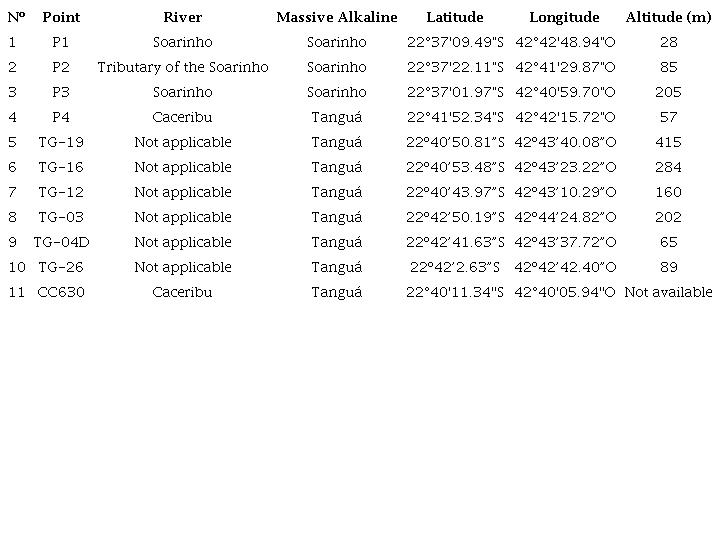
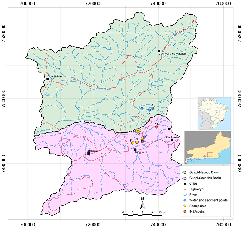
Figure 1
Sampling location points in the Guapi-Macacu and Guapi-Caceribu basins.
2.1 Sample Collection
Water samples were collected on May 10, 2021 by a technician from Qualy Lab Análises Ambientais Ltda., accredited by INEA, and the techniques were based on: ABNT NBR ISO/IEC 17025 standard; Standard Methods for Examination of Water and Wastewater, 22nd edition; EPA methods; ANVISA RE Resolution No. 09/2003; CONAMA Resolution No. 357/2005, and other NBR/ABNT Norms.
On the same day, collections of sediment samples were carried out at each sampling point. Three buckets with a capacity of 10 L/each were collected, the primary beating was carried out, and the resulting material was packed in plastic bags, sealed, and properly identified for further work at the Sample Processing Laboratory (LGPA-UERJ).
2.2 Water Quality Index (WQI)
According to ANA (2022), the WQI incorporates nine variables, namely: Hydrogen Potential (pH); Total Solids (TS); Total Nitrogen (TN); Total Phosphorus (TP); Dissolved Oxygen (DO); Biochemical Oxygen Demand (BOD); Turbidity (T), Water Temperature (T ºC) and Thermotolerant Coliform (TC). Each of the nine parameters has a weight (w), pH (0,12), TS (0,08), TN (0,10), TP (0,10), DO (0,17), BOD (0,10), T (0,08), T ºC (0,10) and TC (0,15). The WQI is calculated based on the weighted product between the parameters and their respective weights, as seen in Equation 1.
where WQI varies between 0 and 100; qi is the quality of the ith parameter; wi is the weight corresponding to the ith parameter fixed according to its importance for quality, between 0 and 1, as shown in Equation 2.
where n is the number of parameters needed to calculate the WQI.
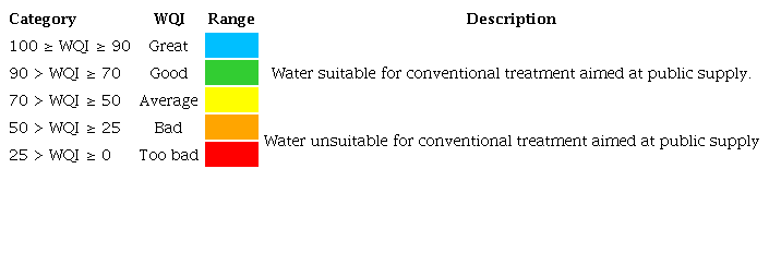
Water quality levels are classified into ranges based on the results obtained by calculating the WQI. The WQI seeks to classify the quality of surface water, having as its main determinant its use for public supply after conventional treatment (CETESB 2010). The State Environmental Institute (Inea 2019) mentions that the WQI values are classified into bands, which vary according to the environmental legislation in each Brazilian state. In the case of the state of Rio de Janeiro, the ranges considered are listed in Table 2.
To estimate the WQI, the application called Water Quality Index - UEPA 1.0, developed by the University of the State of Pará (UEPA), was used. The application is installed via APKPURE App, available at <https://m.apkpure.com/br/%C3%ADndice-de-qualidade-de-%C3%A1gua-uepa/appinventor.ai_fjca.IQA_AULA>. The application is easy to use, as you just need to enter the concentration data of the parameters, the water temperature, and the altitude of the place.
2.3 Parameters Related to Mining Activity
Pollution of soil and aquatic systems by heavy metals is a factor that affects the quality of the environment and constitutes an imminent risk of intoxication to humans. These metals originate from lithogenic processes and/or anthropic activities, such as the use of fertilizers in agricultural areas and mining activities (Muniz & Oliveira-Filho 2006).
Within the scope of the study, parameters were analyzed for: lead, fluorine, manganese, mercury, and zinc. The evaluation of standard classification limits was based on the values established in Ordinance GM/MS 888 of May 4, 2021, and in CONAMA Resolution 357 of March 17, 2005.
2.4 Geophysics
Aiming at the characterization of the geophysical signatures of the main geological occurrences of this work (Cassorotiba Unit and Alkaline Complexes of Soarinho and Tanguá), the geological limits were analyzed in an integrated way with the aerogeophysical data (Maps of the Total Magnetic Field and the Amplitude of the Signal Analytical). For this, we used aerogeophysical data from the Rio de Janeiro Project (Code 1117), published in August 2014 by the Geological Survey of Brazil.
The parameters of the aero geophysical survey were N-S direction of the flight lines; spacing between flight lines of 500 m; E-W direction of control lines; spacing between control lines of 10,000 m; and average flight height of 100 m.
The ground data were obtained by the equipment of the company GEM, model GSM-19, with readings of the magnetic field every 10.0 m. The terrestrial acquisition was carried out along two magnetometric profiles of the variation of the Total Magnetic Field (A and B), with 630 and 510 m, respectively. The data collected by the magnetometer of the Vassouras observatory in the State of Rio de Janeiro was used as a source of information regarding the variation of the Regional Magnetic Field. The software GemLink, v. 5.4 was used to correct the diurnal variation. These data were imported into the Geosoft Oasis Montaj software, where the magnetic profiles were processed.
2.5 Lithogeochemistry
The company ALS Global performed chemical analyzes, which carried out the grinding of the samples, following the methodology of combining rare-earths elements, trace elements, and major oxides. This methodology described the combination of rare-earth elements and traced elements by the ME-MS81 method plus principal oxides by the MEICP06 method. The results were compared to unpublished data from the analysis of alkaline rocks in the region that provide information on the lithotype of the Tanguá massif to identify the origin of the sediments and possible contamination.
3 Results
3.1 Water quality of the Soarinho River
With the three collection points defined, it was possible to trace the schematic topological arrangement of the watercourse, presenting the distances between the collection points, as seen in Figure 2. It is worth noting that point P3 is located immediately downstream of a high-standard residence (differentiated architecture for the region, two floors, swimming pool, housekeeper’s house, and other buildings, in addition to security cameras).
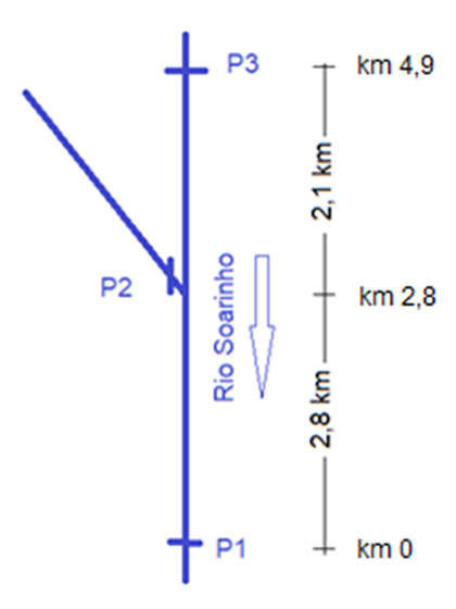
Figure 2
Schematic topological arrangement of the watercourse showing the distances between the collection points.
Table 3 consolidates the laboratory analysis results performed by the company Qualy Lab Análises Ambientais Ltda.
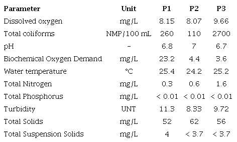
From the analysis of the results, it is observed that the parameters, in general, are below or within the limits of classes 1 and 2, more restrictive of water quality, namely: pH, TP, DO, TDS and T.
The pH did not vary significantly along the studied stretch, 6.8 (P1), 7 (P2) and 6.7 (P3). Results match the established criteria by CONAMA Resolution 357/2005 and the adequate development of aquatic life (Vigil 2003).
The TP parameter also did not show variations along the stretch and with values below 0.01 mg/L, indicating that the Soarinho River has low concentrations of nutrients. This condition points to a low potential or ability to impact water quality and aquatic biota, as mentioned in the studies by Abreu and Cunha (2017).
Regarding the DO, it is worth mentioning that the value equal to 9.66 mg/L measured at point P3 indicates saturation. According to Silva et al. (2013), the dissolution of oxygen in water depends on temperature and pressure, in addition to being affected when biodegradable organic pollutants (household sewage) are released into the receiving stream. Piveli and Kato (2006) mention that the rate of DO reintroduction into natural waters through the surface depends on the hydraulic characteristics and is proportional to the velocity, with the surface reaeration rate in a waterfall being greater than that of a river with normal velocity. Based on the above, the result found can be justified by the hydraulic conditions of point P3 (waterfall with low depth and high speed) and by the fact that it is located at 205 m, the highest altitude among the sampling points.
Regarding the presence of sediments in the water, the laboratory analyzes the total solids (TS), also called total residues (TR), and the total suspended solids (TSS). The TS of the samples collected in the Soarinho River were equal to 52 mg/L (P1), 62 mg/L (P2) and 56 mg/L (P3). The SST totaled 4 mg/L, in P1, and below 3.7 mg/L, in P2 and P3. TS represents the sum of TSS and total dissolved solids (TDS), the latter referring to organic and inorganic substances dissolved in water (Estevam, Silva & Silva 2019). In accordance with CONAMA Resolution 357/2005, which allows up to 500 mg/L of TDS concentration, the results are considerably lower than the limit established by current legislation.
In the case of turbidity, CONAMA Resolution 357/2005 establishes a value of up to 40 UNT for class 1 and 100 UNT for class 2. The results found were 11.3 UNT for P1, 8.33 UNT for P2, and 9, 72 UNT for P3, considerably lower than the limit established by current legislation.
The BOD and TC parameters were those that presented in some points results superior to the limits of classes 1 and 2. The BOD is considered the most common parameter for indicating pollution by organic matter (Fiorucci & Benedetti Filho 2005). Also by the authors, increases in BOD are caused by effluents of predominantly organic origin (domestic sewage), and seriously polluted waters have BOD greater than 10 mg/L. At point P1, located upstream of RJ-116 and representative of the final stretch of the Soarinho River, the BOD reached the value of 23.2 mg/L, violating the standard of water framing, and the place can be considered as seriously polluted. This result endorses the statement by SEA (2013a) when reporting that the riverside population in the region launches the sewage generated in natura directly into water courses. At points P2 and P3, the results were, respectively, 4.4 and 3.6 mg/L, below the class 2 limit. As mentioned before, point P3 is located immediately downstream of a high-end residence that is likely to release domestic sewage in natura into the Soarinho River, and therefore a higher BOD value was to be expected. The low value found can be explained by the high concentration of DO available to oxidize organic matter.
Regarding TC, the values found were 260 (P1), 110 (P2) and 2700 (P3) per 100 mL. In P1, the river falls into class 2, in P2, in class 1 and in P3, in class 3. The existence of source pollution in P1 violated the classification of the source section of the Soarinho river in class 1.
Concerning Total Nitrogen (TN), the values found were 0.3 (P1); 0.6 (P2), and 1.6 (P3). CONAMA Resolution 357/2005 mentions that for fresh waters of classes 1 and 2, the total nitrogen value should not exceed 1.27 mg/L for lentic environments and 2.18 mg/L for lotic environments (art. 10th). The results found indicate that the TN is below the limit values. It is worth mentioning that P3 stands out with the highest value, which, despite being close to the springs, is also close to a large residence with a probability of direct discharge of domestic sewage.
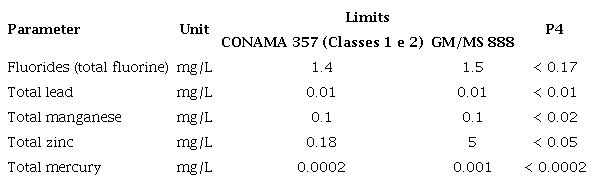
With regard to heavy metals, all results are below the limits recommended by CONAMA Resolution 357/2005 and by Ordinance GM/MS 888/2021, as can be seen in Table 4.

The absence of heavy metals can be explained by the significantly low values of the analysis of total solids (in suspension and dissolved) and turbidity, which indicates the low presence of sediment in the water.
3.2 Water quality of the Caceribu River
As mentioned, in the Caceribu river, only one sampling point was selected, called P4, located nearby the Salto de Braçanã Waterfall. The laboratory results of the water analysis, performed by the company Qualy Lab Análises Ambientais Ltda, are listed in Table 5.
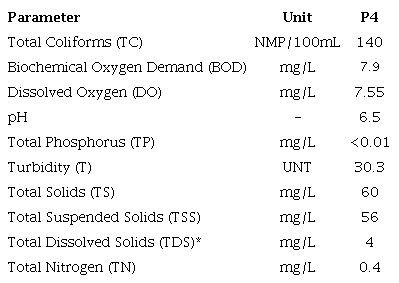
* Obtained by the difference between TS and TSS.
According to CONAMA Resolution 357/2005, it is observed that the parameters, in general, are below or within the limits of class 1, namely: TC, DO, pH, TP, T and TDS. The only exception is BOD, the result of which violates class 1 and class 2 limits.
As mentioned above, BOD is an indicator of pollution by organic matter originating mainly from domestic sewage (Fiorucci & Benedetti Filho 2005). At point P4, the result achieved fits into class 3. Therefore, the use of water for human supply is only viable after conventional or advanced treatment (art. 4 of CONAMA Resolution 357/2005).
Concerning TN, the value should not exceed 1.27 mg/L for lentic environments and 2.18 mg/L for lotic environments (art. 10 of CONAMA Resolution 357/2005). It should be noted that P4 is located in an artificial fall, characterizing a lotic regime. The result found of 0.4 mg/L is much lower than the maximum limit of 2.18 mg/L.
About the presence of heavy metals in water, all laboratory test results are below the limits recommended by CONAMA Resolution 357/2005 and by Ordinance GM/MS 888/2021, as shown in Table 6.
As in the Soarinho River, the absence of heavy metals in the samples from the Caceribu River can be explained by the significantly low values of total solids (in suspension and dissolved) and turbidity, which, in turn, indicate the low presence of sediments in the water.
For comparison, we sought to analyze the results of P4 with the sampling point CC630, located at the headwaters of the Caceribu River, under the responsibility of Inea. To collect the information from the aforementioned sampling point, the water quality bulletins of the Hydrographic Region V - Guanabara Bay, available in INEA (2022), for the period from 2012 to 2019. Then, the historical average of the parameters common to P4 was calculated. The results found are demonstrated in Table 7.
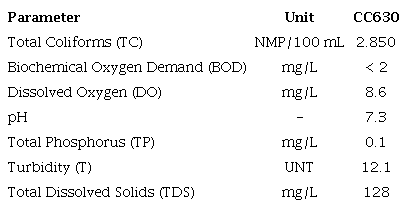
Comparing the results of Tables 5 and 7, it is observed that the parameters DO, pH, TP, T, and TDS, although different, allow the classification of water in class 1, in both sampling points.
With regard to the TC, the P4 sampling point has a lower value than the CC630, so that the first falls into class 1 and the second falls into class 2.
In relation to BOD, there is an inversion, the first fits in class 3 and the second in class 1. As the BOD is an indicator of domestic sewage pollution, the result corroborates the need for tourism planning at point P4.
3.3 Water Quality Index
Using the Water Quality Index - UEPA 1.0 application, the WQI values were calculated for each of the sampling points of the Soarinho and Caceribu rivers. The results are listed in Table 8.
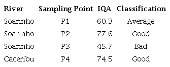
The results of the Soarinho river allow us to infer that P3, the most upstream point, representative of the source of the Soarinho river, was the one with the worst water quality condition. The WQI at point P1 (further downstream) reflects the effects of the mixing zone (dilution) provided by the contribution of the influent (P2), with good quality conditions. The effect of reducing the concentration of pollutants due to dilution by tributaries with better quality or less impacted water was also verified in the studies by Valente et al. (1997), Pinto et al. (2009), and Calmon et al. (2016).
Regarding the Caceribu River, the comparison of the WQI found in P4 with the historical average of CC630 was performed. To this end, in Inea (2022), the average WQI for the period from 2012 to 2019 was consulted, which was equal to 72.56. Both results are close and allow us to classify the waters as good. It should be noted that the WQI estimated for points P4 and CC630 did not have the numerical sensitivity to highlight the difference in the water classification class, motivated by BOD. This is due to the fact that BOD has a weight (w) lower than DO, TC, and pH. This fact is pointed out in the studies by Santos et al. (2016), who mentioned that this is an inconvenience of the WQI, as the parameters with greater weight influence the results more, to the detriment of those with less weight, and in this sense, the WQI does not reflect the pollution of water bodies by the parameters that compose it.
The data monitored on the Soarinho and Caceribu rivers were punctual and not represent a robust historical series. However, they reflect the actual hydrosanitary conditions, mainly of the springs. The springs, in principle, because they are environmentally protected, should have a higher quality than the other stretches of the rivers studied. The issue of analysis of punctual water samples and the relevance of continuous monitoring (frequency of the time-series) was also addressed by Marcé et al. (2016), Pereira, Barbieiro and Quevedo (2020), Oliveira, Hora and Hora (2020), Campos and Nucci (2021).
3.4 Geophysics
The processing of terrestrial geophysical data allowed the elaboration of sections with the variation of Analytical Signal Amplitude, identifying the signatures with the lithological/compositional variation in the region. Figures 3, 4, and 5 present the maps with the identification of the geological main units of the study region and the location of the terrestrial magnetometric geophysical profiles, the Analytical Signal Amplitude Map and Total Magnetic Field Map integrated to the limits of the main units geological features of the region under study.
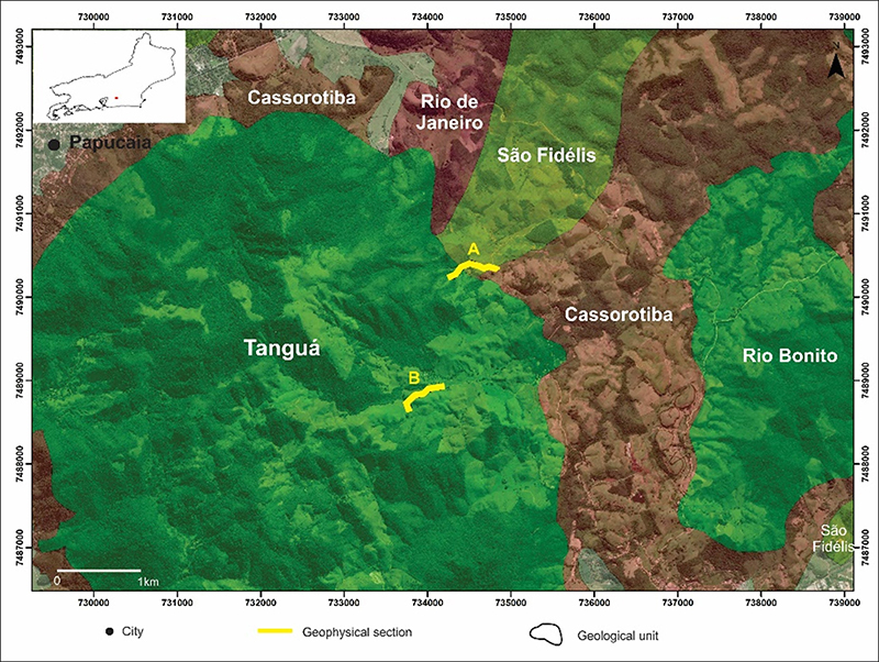
Figure 3
Geological map of the study region, with the main geological units and the location of terrestrial magnetometric geophysical profiles.
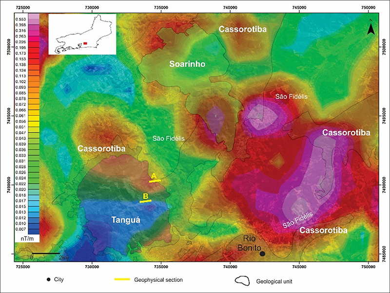
Figure 4
Map of the Amplitude of the Analytical Signal integrated to the limits of the main geological units of the study region.
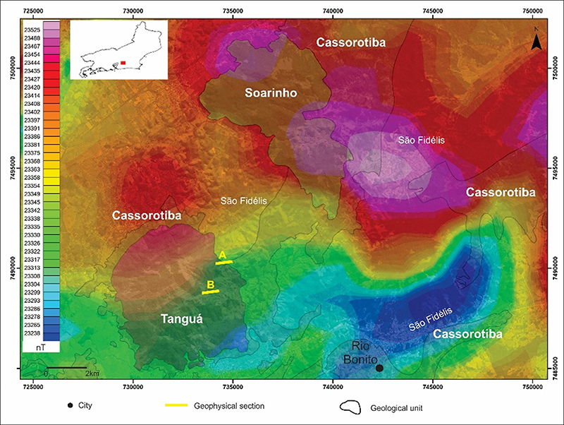
Figure 5
Map of the Total Magnetic Field integrated to the limits of the main geological units in the study region.
The magnetometric profile A displays magnetometric values close to 23,275 Tn for the Tanguá Unit. For the São Fidélis Unit (kinzigite), the values reach maximums of 23500 Tn, decreasing as it approaches the contact with the Cassorotiba Unit. It is worth mentioning that according to Serviço Geológico do Brasil (2012), the São Fidélis Group is subdivided into the units (sillimanite)-biotite, amphibolite, and kinzigite and as reported by Martins et al. (2021), Cassorotiba Unit is represented by garnet-biotite orthogneiss. The marked variation of the Total Magnetic Field between the Tanguá and São Fidélis units may indicate a vertical to subvertical geological contact between them. On the other hand, the geological contact between the São Fidélis and Cassorotiba units exhibits a gradual decay of the values of the Total Magnetic Field, indicating a smooth dip to the NE, as can be seen in Figure 6.
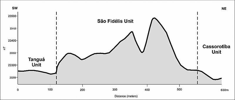
Figure 6
Magnetometric geophysical profile (A in Figures 3, 4 and 5) integrated with the geological data of the study area.
The magnetometric profile B exhibits variation in magnetometric values, with a minimum of 23,500 nT and a maximum of 24,050 nT. The entire profile is located in the Tanguá Unit. The magnetometric variations can be interpreted as compositional variations in this Unit, with enrichment of ferromagnetic minerals from NE to SW. At the SW end of the profile, the magnetometric values show values close to 23,500 nT, reinforcing the compositional heterogeneity of the body, as can be seen in Figure 7 below.
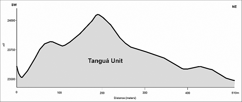
Figure 7
Magnetometric geophysical profile (B in Figures 3, 4 and 5) integrated with the geological data of the study area.
3.5 Lithogeochemistry
Both types of material of interest (sediments and rock) assist in the chemical comparison to trace possible values that characterize contamination by heavy metals in river beds, either by a signature of the environment (background) or external agents. In the case of chemical studies on the sediments and outcropping lithotypes of the Tanguá alkaline massif, they show that the range presented overlaps (see Tables 9 and 10 for comparison).
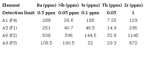
Note: 44 elements were analyzed by ICP-MS from which we selected 5 elements of interest.
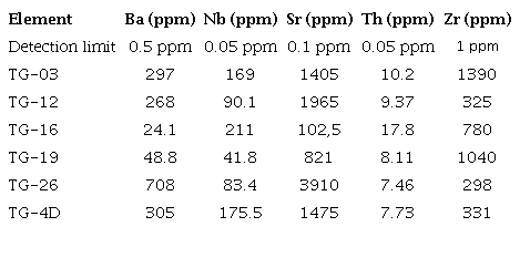
Note: 57 elements were analyzed by ICP-MS from which we selected 5 of interest.
Comparing the results of the collected samples and the results of the outcropping samples from the Tanguá alkaline massif present the same chemical composition for the intervals present in the sediments (Table 9) for the elements Ba (ca. 100-300 ppm), Nb (ca. 30-190 ppm), Sr (ca. 30-190 ppm), Th (ca. 15-33 ppm) and Zr (ca. 130-1150 ppm) not out of line with the ranges observed in Table 10 for the Tanguá lithotypes (e.g., nepheline syenites, mostly and, secondarily, phonolites).
4 Conclusions
The Caceribu and Soarinho rivers showed good potential for local human supply. Points P1 and P2 are within acceptable limits, demonstrating the self-depuration competence of the Soarinho River. Mixing zone effects were also reflected in the WQI results for the Soarinho River at point P1. However, it should be highlighted that the expected WQI regarding points P4 and CC630 did not have the numerical sensitivity to emphasize the difference in water classification class, justified by the fact that BOD has a lower weight than DO, TC and pH.
The magnetometric data confirms that the drainage areas belong to the alkaline context studied. There is no evidence that mining activities compromise water quality. The samples collected directly from the alkaline massifs and the results of the bed material samples at points P1, P2, P3, and P4 demonstrate the same chemical composition of the region's background, proving the area of interaction of water bodies and alkaline rocks.
We recommend continuing monitoring to support control and inspection actions to protect the rivers, especially those used for human supply, and to enable correct evaluation of water quality variations over time and hydrological seasonality.
5 References
Abreu, C.H.M. & Cunha, A.C. 2017, 'Qualidade da água e índice trófico em rio de ecossistema tropical sob impacto ambiental', Engenharia Sanitaria e Ambiental, vol. 22, no. 1, pp. 45-56, DOI:10.1590/S1413-41522016144803
Almeida, F.F.M., Hasui, Y., de Brito Neves, B.B. & Fuck, R.A. 1981, 'Brazilian structural provinces: An introduction', Earth-Science Reviews, vol. 17, no. 1-2, pp. 1-29, DOI:10.1016/0012-8252(81)90003-9
ANA - Agência Nacional de Águas 2022, Portal da Qualidade das Águas, Indicadores de Qualidade - Índice de Qualidade das Águas (IQA), Brasília, viewed 22 April 2022, <ANA - Agência Nacional de Águas 2022, Portal da Qualidade das Águas, Indicadores de Qualidade - Índice de Qualidade das Águas (IQA), Brasília, viewed 22 April 2022, http://pnqa.ana.gov.br/rede-nacional-rede-monitoramento.aspx>.
ANM - Agência Nacional de Mineração 2022, Sistema de Informações Geográficas da Mineração (SIGMINE), Rio de Janeiro, viewed 15 January 2022, <ANM - Agência Nacional de Mineração 2022, Sistema de Informações Geográficas da Mineração (SIGMINE), Rio de Janeiro, viewed 15 January 2022, https://dados.gov.br/dados/conjuntos-dados/sistema-de-informacoes-geograficas-da-mineracao-sigmine>.
Aumond, J.J. & Scheibe, L.F. 1996, 'O fonolito de Lages-SC, um novo fundente cerâmico brasileiro', Cerâmica Industrial, vol. 1, no. 2, pp. 17-21.
Biondi, J.C. 2003, Processos metalogenéticos e os depósitos minerais brasileiros, 1st edn, Oficina de textos, São Paulo.
Calmon, A.P.S., Souza, J.C., dos Reis, J.A.T. & Mendonça, A.S.F. 2016, 'Uso combinado de curvas de permanência de qualidade e modelagem da autodepuração como ferramenta para suporte ao processo de enquadramento de cursos d’água superficiais', RBRH, vol. 21, no. 1, pp. 118-33, DOI:10.21168/RBRH .V21N1.P118-133
Campos, J.C. & Nucci, J.C. 2021, 'Protocolo de Avaliação Rápida de Rios Urbanos (PARU) como ferramenta de monitoramento ambiental', GOT, no. 21, pp. 121-38, DOI:10.17127/got/2021.21.005
CETESB - Companhia Ambiental do Estado de São Paulo 2010, Significado Ambiental e Sanitário das Variáveis de Qualidade das Águas e dos Sedimentos e Metodologias Analíticas de Amostragem, Série Relatórios/CETESB, 2nd edn, CETESB - Companhia Ambiental do Estado de São Paulo, São Paulo.
Da Silva, D.A., Geraldes, M.C., Rodrigues, S.W.O., McMaster, M., Evans, N., Nummer, A.R. & Vargas, T. 2018, '(U-th)/he ages from the fuorite mineralization of the Tanguá Alkaline intrusion', Anuário do Instituto de Geociencias, vol. 41, no. 2, pp. 14-21, DOI:10.11137/2018_2_14_21
Dantas, M.E., Renk, J.F.C., Shinzato, E., Souza, L.V., Calderano, S.B., Fidalgo, E.C.C. & Aranda, C.C.C. 2012, Geomorfologia das Bacias dos Rios Guapi-Macacu e Caceribu - Recôncavo da Baía de Guanabara Estado do Rio de Janeiro, Embrapa Solos, Rio de Janeiro.
Estevam, M., Silva, A.W. & Silva, F.F. 2019, 'Physical analysis of entry water in the agro-industry system of tannery in the city of Maringá- Paraná', Ciência E Natura, vol. 41, e16, DOI:10.5902/2179460X36610
Fiorucci, A.R. & Benedetti Filho, E. 2005, 'A importância do oxigênio dissolvido em ecossistemas aquáticos', Química nova na escola, no. 22, pp. 10-6.
Heilbron, M., Pedrosa-Soares, A.C., Campos Neto, M.C., Silva, L.C., Trouw, R.A.J., & Janasi, V.A. 2004, 'Província Mantiqueira', in Geologia do continente sul-americano: Evolução da obra de Fernando Flávio Marques de Almeida, Beca, São Paulo, pp. 203-33.
Heilbron, M., Eirado, L.G. & Almeida, J. 2016, Mapa geológico e de recursos minerais do estado do Rio de Janeiro, Escala 1:400.00, viewed 15 January 2022, <00, viewed 15 January 2022, https://rigeo.cprm.gov.br/handle/doc/18458>.
INEA - Instituto Estadual do Ambiente 2019, Índice de Qualidade da Água (IQA) - Metodologia, Índice de Qualidade da Água (IQA) - Metodologia, Rio de Janeiro, viewed 4 April 2022, < INEA - Instituto Estadual do Ambiente 2019, Índice de Qualidade da Água (IQA) - Metodologia, Índice de Qualidade da Água (IQA) - Metodologia, Rio de Janeiro, viewed 4 April 2022, http://www.inea.rj.gov.br/wp-content/uploads/2019/04/IQA-NSF-Metodologia-Qualidade-de-Água.pdf>.
INEA - Instituto Estadual do Ambiente 2022, Qualidade das Águas por Região Hidrográfica (RHs) - Bacia da Baía de Guanabara, Boletins de Qualidade das Águas por Região Hidrográfica, Rio de Janeiro, viewed 10 July 2022, <INEA - Instituto Estadual do Ambiente 2022, Qualidade das Águas por Região Hidrográfica (RHs) - Bacia da Baía de Guanabara, Boletins de Qualidade das Águas por Região Hidrográfica, Rio de Janeiro, viewed 10 July 2022, http://www.inea.rj.gov.br/ar-agua-e-solo/qualidade-das-aguas-por-regiao-hidrografica-rhs/>.
Marcé, R., George, G., Buscarinu, P., Deidda, M., Dunalska, J., Eyto., E., Flaim, G., Grossat, H.P., Istvanovics, V., Lenhardt, M., Moreno-Ostos, E., Obrador, B., Ostrovsky, I., Pierson, D.C., Potuzak, J., Poikane, S., Rinke, K., Rodriguez-Mozaz, S., Staehr, P.A., Sumberova, K., Waajen, G., Weyhenmeyer, G.A., Weathers, K.C., Zion, M., Ibelings, B.W. & Jennings, E. 2016, 'Automatic high frequency monitoring for improved lake and reservoir management', Environmental Science & Technology, vol. 50, no. 20, pp. 10780-94, DOI:10.1021/acs.est.6b01604
Martins, G., Mendes, J.C., Schmitt, R.S. & Armstrong R. 2021, 'Unravelling source and tectonic environment of an Ediacaran magmatic province from southeast Brazil: Insights from geochemistry and isotopic investigation', Lithos, vol. 404-405, e106428, DOI:10.1016/j.lithos.2021.106428
Muniz, D.H.F. & Oliveira-Filho, E.C. 2006, 'Metais pesados provenientes de rejeitos de mineração e seus efeitos sobre a saúde e o meio ambiente', Universitas: Ciências Da Saúde, vol. 4, no. 1, pp. 83-100, DOI:10.5102/ucs.v4i1.24
Oliveira, M.C.S., Hora, M.A.G.M. & Hora, A.F. 2020, 'Metodologia para Estimativa do Índice de Qualidade das Águas. Estudo de Caso dos Rios Tributários ao Reservatório de Juturnaíba, Estado do Rio de Janeiro', Anuário do Instituto de Geociências, vol. 43, no. 3, pp. 386-401, DOI:10.11137/2020_3_386_401
Pereira, M. A.F., Barbieiro, B.L. & Quevedo, D. M. 2020, 'Importance of monitoring and availability of hydrological data for integrated water resources management', Sociedade & Natureza, vol. 32, pp. 308-20, DOI:10.14393/SN-v32-2020-43458
Pinto, A.G.N., Horbe, A.M.C., da Silva, M.S.R., Miranda, S.A.F., Pascoaloto, D. & Santos, H.M.C. 2009, 'The human action effects on the hydrogeochemistry of Negro river at the Manaus shoreline', Acta Amazonica, vol. 39, no. 3, pp. 627-38, DOI:10.1590/s0044-59672009000300018
Piveli, R.P. & Kato, M.T. 2006, Qualidade das águas e poluição: aspectos físico-químicos, Abes - Associação Brasileira Eng Sanitária Ambiental, São Paulo.
Ribeiro, G.M. 2018, 'Caracterização de pós de rochas silicáticas, avaliação da solubilidade em ácidos orgânicos e potencial de liberação de nutrientes como remineralizadores de solos agrícolas', DSc. Thesis, Universidade do Estado de Santa Catarina.
Ross, J.L.S. 1985, 'Relevo Brasileiro: Uma Nova Proposta De Classificação', Revista do Departamento de Geografia, vol. 4, pp. 25-39, DOI:10.7154/RDG.1985.0004.0004
Santos, V.J., Oliveira, F.B.S. & Palmeira, E.S. 2016, ‘Contribuição Individual Dos Parâmetros De Qualidade Da Água Para O Iqa Do Rio Cachoeira, Região Sul Da Bahia’, Revista Eletrônica de Gestão e Tecnologias Ambientais, vol. 4, no. 2, pp. 252-9.
SEA - Secretaria Estadual do Ambiente 2013a, Plano Municipal de Saneamento Básico - Água e Esgoto de Cachoeiras de Macacu, viewed 20 April 2022, <SEA - Secretaria Estadual do Ambiente 2013a, Plano Municipal de Saneamento Básico - Água e Esgoto de Cachoeiras de Macacu, viewed 20 April 2022, https://onedrive.live.com/?authkey=%21AHhgpUkf0FWkpAY&cid=396F7534AC5D69C4&id=396F7534AC5D69C4%219228&parId=396F7534AC5D69C4%219214&o=OneUp>
SEA - Secretaria Estadual do Ambiente 2013b, Plano Municipal de Saneamento Básico - Água e Esgoto de Rio Bonito, viewed 13 April 2022, <SEA - Secretaria Estadual do Ambiente 2013b, Plano Municipal de Saneamento Básico - Água e Esgoto de Rio Bonito, viewed 13 April 2022, https://onedrive.live.com/?authkey=%21AHHdBFT8nZq2LYU&cid=396F7534AC5D69C4&id=396F7534AC5D69C4%219238&parId=396F7534AC5D69C4%219212&o=OneUp>
SEA - Secretaria Estadual do Ambiente 2017, Plano Municipal de Conservação e Recuperação da Mata Atlântica de Rio Bonito, viewed 13 April 2022, <SEA - Secretaria Estadual do Ambiente 2017, Plano Municipal de Conservação e Recuperação da Mata Atlântica de Rio Bonito, viewed 13 April 2022, http://aemerj.org.br/images/pdf/PMMA/PMMARioBonito.pdf>
Serviço Geológico do Brasil 2012, Geologia e recursos minerais da folha São Fidélis SF.24-V-C-IV, estado do Rio de Janeiro escala 1:100.000, CPRM, Belo Horizonte.
Silva, V.P.R., Aleixo, D.O., Dantas Neto, J., Maracajá, K.F.B. & Araújo, L.E. 2013, 'Uma medida de sustentabilidade ambiental: pegada hídrica', Revista Brasileira de Engenharia Agrícola e Ambiental, vol. 17, no. 1, pp. 100-5, DOI:10.1590/S1415-43662013000100014
UFF/FEC - Universidade Federal Fluminense/Fundação Euclides da Cunha 2010, Planejamento Estratégico da Região Hidrográfica dos Rios Guapi-Macacu e Caceribu-Macacu, Nietrói, viewed 20 April 2022, <UFF/FEC - Universidade Federal Fluminense/Fundação Euclides da Cunha 2010, Planejamento Estratégico da Região Hidrográfica dos Rios Guapi-Macacu e Caceribu-Macacu, Nietrói, viewed 20 April 2022, http://www.projetomacacu.uff.br/>
Valente, J.P.S., Padilha, P.M. & Silva, A.M.M. 1997, 'Oxigênio dissolvido (OD), demanda bioquímica de oxigênio (DBO) e demanda química de oxigênio (DQO) como parâmetros de poluição no ribeirão Lavapés/Botucatu - SP', Eclética Química, vol. 22, pp. 49-66, DOI:10.1590/S0100-46701997000100005
Vigil, K.M. 2003, Clean water: an introduction to water quality and water pollution control, 2nd edn, Oregon State University Press, Corvallis.
Funding information
Data availability statement
Author notes
E-mail: marcos_cbarros@hotmail.comE-mail: andcostasantos@gmail.comE-mail: monicahora@id.uff.brE-mail: salomao.mss@gmail.comE-mail: antoniohora@id.uff.brE-mail: marcomaia.geo@hotmail.com
Conflict of interest declaration