Artigo
Natural Disasters in the Metropolitan Region of Belo Horizonte: A Summary of Events Occurred in the Rainfall Period of 2019/2020
Desastres Naturais na Região Metropolitana de Belo Horizonte: Uma Síntese dos Eventos Ocorridos no Período Chuvoso de 2019/2020 Natural
 Denise de Fátima Santos da Silva denisefss@yahoo.com.br
Maria Giovana Parisi mgparizzi18@gmail.com
Elaine Aparecida Santos da Silva laninhambiental@gmail.com
Guilherme Andrade Ranier Silva gui.ranier@gmail.com
Denise de Fátima Santos da Silva denisefss@yahoo.com.br
Maria Giovana Parisi mgparizzi18@gmail.com
Elaine Aparecida Santos da Silva laninhambiental@gmail.com
Guilherme Andrade Ranier Silva gui.ranier@gmail.com
Natural Disasters in the Metropolitan Region of Belo Horizonte: A Summary of Events Occurred in the Rainfall Period of 2019/2020
Anuário do Instituto de Geociências, vol. 46, 48923, 2023
Universidade Federal do Rio de Janeiro
Received: 16 December 2021
Accepted: 12 March 2022
Abstract: This article presents a summary and analysis of the consequences on the latest disasters that occurred in Minas Gerais, especially in the Metropolitan Region of Belo Horizonte (RMBH). The databases used in this study were the bulletins from the main bodies that manage water resources and natural disasters in the state of Minas Gerais, such as Civil Defense, CEMADEN, IGAM and CEPED-UFSC. It is worth mentioning that the cities of Belo Horizonte, Ibirité and Florestal were the holders of pluviometry records in the rainy period of 2019/2020 and therefore, carry the largest numbers with regard to material damage (Ibirité) and the deaths (Belo Horizonte). Nevertheless, it is important to highlight the significant number of injured, sick and homeless people due to the bad weather in Contagem. It is known that the RMBH has a vast history of events related to natural disasters and bottlenecks regarding urban planning. Therefore, the identification of these risk areas is a very important tool for mapping vulnerable locations and drawing concrete action plans aimed at neutralizing events, strengthening the city's urban infrastructure and mainly preserving lives.
Keywords: Risk management, Landslides, Flooding.
Resumo: Este artigo apresenta uma síntese e análise das consequências sobre os últimos desastres ocorridos em Minas Gerais, sobretudo na Região Metropolitana de Belo Horizonte (RMBH). A base de dados utilizada neste estudo foram os boletins dos principais órgãos que gerem os recursos hídricos e os desastres naturais no estado de Minas Gerais, como a Defesa Civil, o CEMADEN, o IGAM e o CEPED-UFSC. Vale ressaltar que as cidades de Belo Horizonte, Ibirité e Florestal figuraram, no período chuvoso de 2019/2020, como detentoras de recordes pluviométricos e, por conseguinte, carregam os maiores números no que diz respeito a danos materiais (Ibirité) e a perda de vidas (Belo Horizonte). Não obstante, é importante destacar a quantidade expressiva de feridos, enfermos e desabrigados em virtude das intempéries na cidade de Contagem. Sabe-se que a RMBH possui um vasto histórico de eventos relacionados a desastres naturais e a gargalos no que tange o planejamento urbano. Sendo assim, a identificação dessas áreas de risco é uma ferramenta muito importante para mapear os locais vulneráveis e traçar planos de ação concretos objetivando neutralizar as ocorrências, fortalecer a infraestrutura urbana da cidade e, principalmente, preservar vidas.
Palavras-chave: Gerenciamento de risco, Movimentos de massa, Enchentes.
1 Introduction
Landslides and flooding are natural disasters that happened frequently in Brazil. The diversity of geological and geomorphological characteristics from Minas Gerais State linked to tropical climate conditions are the main responsible triggering of landslides and floods. The fact is further aggravated by an inefficient urban planning, with a considerable increase of the disorderly occupation of river banks, and especially of hillsides in addition to global warming, which directly affects the hydrological cycle.
Geological processes occur naturally on the planet, but they can be induced and/or enhanced by anthropic action through slope/landfill cutting, waste disposal, removal of vegetation cover, changes in river dynamics. Parizzi (2014) points out that the construction of cities demands consequently builds that increasingly de-characterize natural landscapes. Each occupied space presents a specific set of responses to socio-environmental changes, therefore, requires individual attention due to potential disasters and accidents that can directly affect the population that lives there.
According to the "Relatório de danos materiais e prejuízos decorrentes de desastres naturais no Brasil: 1995 - 2019" developed by the Center for Studies and Research in Engineering and Civil Defense of the Federal University of Santa Catarina (CEPED-UFSC) in 2020, the distribution of damage and losses in Brazil is concentrated in the states of Rio Grande do Sul, Minas Gerais, Bahia, Pernambuco and Santa Catarina. This means that the total damage and losses from these states combined account for almost half (49.14%) of the total of R$ 333.36 billion in losses in Brazil.
Intense and persistent rainfall is the major contributor to the occurrence of natural disasters ( Kobiyama et al. 2006; Alvarenga 2012). In addition, climate changes directly affect precipitation and temperature averages, frequency and intensity of extreme events, and changes in soil moisture ( Xu et al. 2011; Stagl et al. 2014). Extreme rainfall events are frequent in Belo Horizonte, mainly between the months of November and February. Assis et al. (2013) explain that the topographic irregularity of the city of Belo Horizonte and the action of unstable atmospheric systems, associated with intense occupation and soil sealing, are primarily responsible for the recurrence of inundation and landslides events. Furthermore, these same authors emphasizes that these problems are aggravated by the disorderly growth of the capital city in regions lacking urban infrastructure, especially the irregular occupation of the slopes of Serra do Curral and the valley bottoms of the hydrographic basins of Ribeirão Arrudas and Córrego do Onça.
The main system which regulates precipitation throughout summer in South America is the South Atlantic Convergence Zone (SACZ), and because it is a persistent system, it can contribute to the occurrence of geohydrological disasters ( Quadro 1994; Lima et al. 2010). Abreu (1998) in his study describes the SACZ and its effects on the state of Minas Gerais. This author explains that the SACZ is formed by the association between the Atlantic Polar Front (APF) and tropical convection, coming mainly from the Amazon region. According to Simões et al. (2012) in the city of Belo Horizonte, especially on Cristiano Machado Avenue, the SACZ plays an important role in the occurrence of precipitation, and in the rainy season of 2011/2012, there was a strong action of this convergence zone. However, Simões et al. (2012) points out that in the aforementioned period, some anomaly was recorded, especially in December and February.
Many studies describe the geological and/or hydrological disasters that occurred in some Brazilian regions, as can be seen in Lima et al. (2010) in the southeastern region of Brazil; Dourado et al. (2012), Silva et al. (2012) and Dereczynski et al. (2017) in the region of the state of Rio de Janeiro; Vargas Jr and Campos (2015) in Rio Grande do Sul and Magnago et al. (2021) in Santa Catarina. It can also highlight the studies that expose natural disasters occurred in the Metropolitan Region of Belo Horizonte (RMBH) such as Parizzi et al. (2010a), Parizzi et al. (2011), Simões et al. (2012), Assis et al. (2013), Parizzi (2014), Nunes (2018), Lucas et al. (2018) and Pedro et al. (2020). Studies such as the ones mentioned above are fundamental to the understanding of the criteria adopted for risk management in urban areas, besides contributing with information and awareness of disaster prevention agencies and the population in general, because it might help in the prevention and preparation to face these events.
This article presents a summary of the latest disasters that have occurred in Minas Gerais, especially in RMBH, and presents the impacts of these phenomena. The RMBH has several risk areas with a high number of occurrences. This is caused by the characteristics of the geomechanical conditions of the rocks inserted in this region, which favor the development of erosive processes and consequent instability of the terrain. In view of the intense growth of the RMBH and the increasing need for more detailed information, with the elaboration of maps and thematic maps for urban planning, the RMBH is a region that deserves attention, according to the works of Parizzi et al. (2011) and Reis Junior and Parizzi (2019). In addition, this study can help the risk management of the region and subsidize the planning and improvement of actions aimed at risk reduction in the country, especially during rainy periods.
2 Basic Concepts Used in Natural Disasters Management
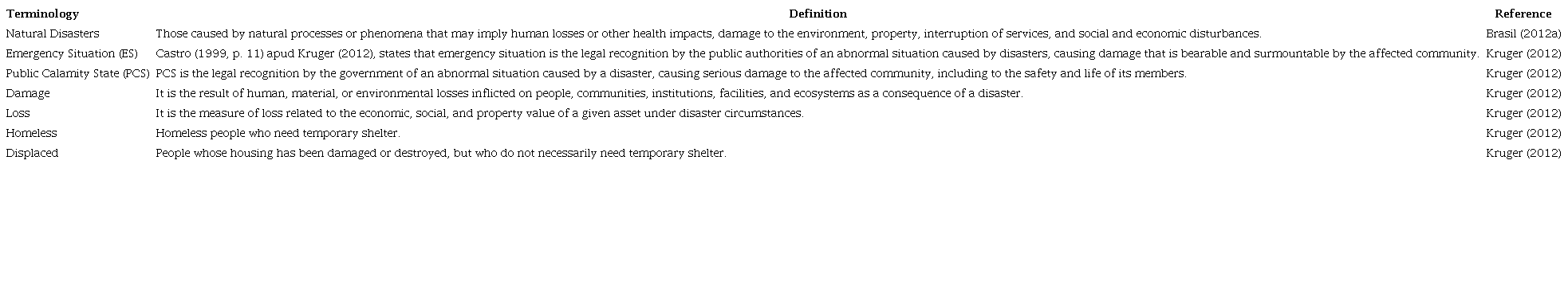
Worldwide or even within the same country, unfortunately, there is rarely uniformity in terminology and the results of risk area zoning are not often precisely defined. The terminologies used in risk management are frequently used interchangeably, but here in this article we will use the definitions according to Table 1.
It is worth noting that ES is characterized by the imminence of damage to health and public services. The PCS is decreed when these situations are installed. Agência Senado (2020) emphasizes that it is up to the mayor to assess the situation and decree the ES or PCS, because these are cases in which there is the possibility of obtaining federal and state resources facilitated for the mitigation of damage and losses.
The Brazilian Disaster Codification (COBRADE) was instituted to replace the Codification of Disasters, Threats and Risks (CODAR). COBRADE was developed from the classification used by the International Database for Disasters (EM-DAT) of the Center for Research on the Epidemiology of Disasters (CRED) and the World Health Organization (WHO/UN). In addition to the disasters included in the EM-DAT classification, some disasters peculiar to the Brazilian reality were included ( Brasil 2012b). According to COBRADE there are two categories of disasters, which are natural disasters and technological disasters. Natural disasters are subdivided into geological, hydrological, meteorological, climatological, and biological. This article will address the geological and hydrological disasters that have occurred in RMBH, such as landslides and floods.
Situations of abnormality such as ES and PCS can only be decreed as a result of a disaster, so to be considered a disaster in Brazil, it is essential that the disaster has been catalogued in COBRADE. In addition, the classification of disasters allows for the formation of databases that can be used for eventual studies on the occurrence of disasters in the country, enabling the adoption of preventive measures to address adverse situations ( Brasil 2012b).
3 RMBH Characteristics
Located in the central portion of the state of Minas Gerais, the Metropolitan Region of Belo Horizonte is composed of 34 cities and according to IBGE (2015) it covers an area of 9471.7 km². The region is inserted in the context of the São Francisco Craton and is constituted to the south, by the rocks of the Quadrilátero Ferrífero, in a central portion, by granite-gneissic rocks of the Belo Horizonte and Caeté metamorphic complexes, and to the north by rocks of the Bambuí Group and Espinhaço Supergroup ( Reis Junior 2016).
According to Parizzi et al. (2011), the RMBH has varied geology, ranging from highly weathered rocks to residual soils, highly susceptible to mass movement. It is possible to highlights phyllites and schists with high degree of weathering, gneiss residual soils and thallus deposits. Parizzi et al. (2010b) produced a geotechnical topology identification map, which identified 10 units that are grouped according to similar compositions and behaviors. The dominant lithologies present in each geotechnical unit are: 1 - Granite-gneissic rocks; 2 - Siltstone; 3 - Itabirites; 4 - Foliated metamorphic rocks; 5 - Dolomites; 6 - Quartzites; 7 - Metaultramafic and metadianasian rocks; 8 - Laterites and various sediment deposits; 9 - Metagraywackes e metasandstones and 10 - Limestones. Figure 1A shows location map and Figure 1B shows geotechnical RMBH units.
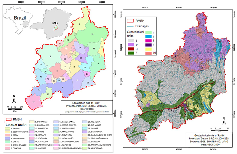
Figure 1
A. Location map; B. Geotechnical map of RMBH units.
According to Köppen's climate classification, the largest portion of the RMBH is inserted in the Cwb type (humid temperate climate with temperate summer and dry winter), while a small portion corresponds to the Cwa type (humid temperate climate with hot summer and dry winter) ( Alexandre et al. 2010). Lucas et al. (2018) concluded that in the rainy seasons between 2010 and 2012 the Cold Fronts (CF) were the most recurrent systems in Belo Horizonte, followed by the action of the SACZs, but if the convergence zones are considered in total (SACZ and MCZ - Moisture Convergence Zone), they correspond to almost 40% of the atmospheric systems acting in the region.
According to Lucas et al. (2018) the city of Belo Horizonte is characterized by being an impermeable city and having straightened streams. These authors also state that rainfall with maximum intensities of less than 10 mm/h does not tend to cause hydrological impacts; however, rainfall records with intensity between 10 and 17.9 mm/h show a tendency to increase the number of recorded events, with rainfall intensity above 30 mm/h, and the records become more recurrent.
4 Methodology
In order to search for the occurrences of meteorological events that were characterized as natural disasters in the rainy period from October 2019 to March 2020, a catalog of the events that occurred in Minas Gerais was carried out with emphasis on the events that occurred in the RMBH. This catalog was prepared from the records of the main media such as newspapers and magazines, in addition to data from the Civil Defense Bulletins of the state of Minas Gerais. In addition, the "Boletim da sala de situação - 1º trimestre de 2020" prepared by the National Center for Monitoring and Alerts of Natural Disasters (CEMADEN), the "Relatório técnico do período chuvoso 2019-2020" prepared by the Minas Gerais Institute of Water Management (IGAM) and the " Relatório de danos materiais e prejuízos decorrentes de desastres naturais no Brasil: 1995 - 2019" prepared by CEPED-UFSC in 2020 were also consulted.
To the event being considered an occurrence related to a natural disaster caused by rain, at least one of the following criteria was considered: existence of homeless and/or displaced persons, deaths, structural damage, landslide or river overflow events, declaration of a situation of emergency, or declaration of a situation of public calamity. This catalog was prepared in spreadsheets, where as much information as possible about the occurrences was registered, such as location, type of event, date of occurrence, number of people affected etc. 105 occurrences were catalogued from the Civil Defense bulletins of the state of Minas Gerais and 14 occurrences from the Internet media.
The rainfall maps of the RMBH were made from data of 17 rainfall stations, and of these 17 stations; data from 5 were discarded for containing missing and/or inconsistent data. The data from these rainfall stations were obtained through the ANA's National Hydrometeorological Network, acquired from Hidroweb, where hydrological data in historical series are available. The rainfall stations are distributed throughout RMBH and the period of data analyzed corresponds to the average of the rainy period 2019/2020 and the accumulated rainfall of the month of January 2020.
ArcGIS 10.3 software was used to prepare the rainfall maps of the RMBH and the mathematical model applied was the deterministic interpolation Inverse Distance Weighting (IDW). According to Jakob and Young (2006) the IDW predicts a value for some unmeasured point using the values sampled around it. Marcuzzo et al. (2011) explain that the weight of each point is the inverse of a function of the distance, which will have a greater weight than the more distant values, that is, each point has an influence on the new point, which decreases as the distance increases. Marcuzzo et al. (2011) also points out that the IDW is a computationally fast method, since the definition of the weights for the linear weighting is done in a simplistic manner.
5 Results and Discussions
The RMBH is a region of high urbanization and the areas at risk of geohydrological events are inserted in the urban area domain. These events occur both in areas of high building standards and in areas of low building standards which reinforces the importance of physical conditioning factors in the triggering of these processes ( Parizzi et al. 2010a). However, in more precarious regions where socioeconomic vulnerability is high, the risk is aggravated by many factors including the increase of irregular occupations and the lack of infrastructure.
CEPED-UFSC (2020) registered between the years 1995 and 2019 a total of 64429 disasters in Brazil. Within the analyzed period of the 5570 Brazilian municipalities, about 85% registered some occurrence with material damage or losses, accounting for a total of R$ 333.36 billion in losses. The private and public losses were estimated at R$ 266.81 billion and the material damages were estimated at R$ 66.54 billion.
Furthermore, according to CEPED-UFSC (2020), for the total number of events 60.32% of the material damage and losses in Brazil are originated mainly by climatological disasters and 34.47% by hydrological disasters. Geohydrological events are concentrated mainly in the rainy season, between the months of October and March.
During the years 1981 to 2010, INMET recorded in the state of Minas Gerais the total rain over these 30 years ranged from approximately 1400 mm to values below 800 mm. In the rainy period between the months of October/2019 to March/2020, in Minas Gerais the rainfall accumulations totaled values between 400 mm and 2100 mm, approximately ( IGAM 2020).
At the end of January 2020, the meteorological phenomenon called SACZ (South Atlantic Convergence Zone) was responsible for the torrential rain events that, according to IGAM (2020) totaled values greater than 100 mm in a period of only 24 hours. Figure 2A shows the accumulated rainfall for the rainy season and Figure 2B shows the accumulated rainfall for the month of January in the RMBH. From Figures 2A and 2B it is possible to verify that the rainy season precipitation accumulation corresponded up to approximately 1600 mm in the central region of RMBH.
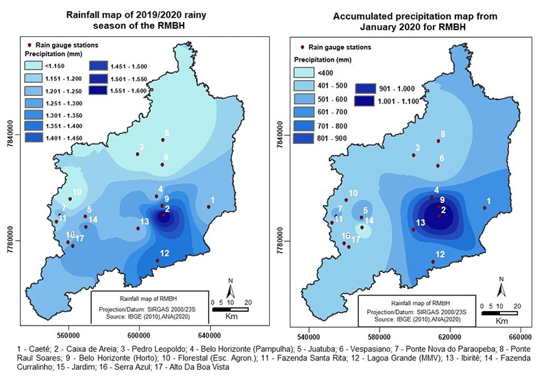
Figure 2
Accumulated precipitation: A. During the entire 2019/2020 rainy season; B. Accumulated rainfall in the month of January in RMBH.
Besides that, it is also possible to verify that only during the month of January the central region presented accumulated precipitation of up to 1100 mm, which is almost 70% of the total rainfall in the entire rainy season. This amount of concentrated rain especially at the end of January was responsible for several occurrences of mass movements, mudslides and floods in the cities of Ibirité, Betim and Belo Horizonte.
Figure 3A presents the frequency of the monthly rainfall totals of the 2019/2020 rainy season and Figure 3B shows the total for the month of January 2020 of the 12 stations used in the RMBH. From Figure 3 it is possible to observe that the rainfall intensity was better distributed in the RMBH region during the entire 2019/2020 rainy period compared only to the month of January 2020. In addition, it is possible to observe that in January 2020 there was a record of extreme rainfall values (accumulated above 900 mm). This can be attributed to the concentration of rainfall in the central portion of the RMBH during the month of January.
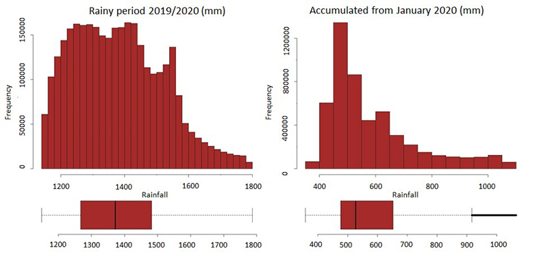
Figure 3
Statistical analysis: A. Rainfall data for the cumulative total of January 2020; B. 2019/2020 rainy period in RMBH.
Currently, CEMADEN monitors 28 cities in RMBH and, according to the “Boletim da Sala de Situação” for the first quarter of 2020, all of them received geohydrological risk warnings about possible storm consequences. The bulletin also informed that among the monitored municipalities, 13 have suffered some kind of impact and had decrees of emergency or public calamity recognized by the federal government.
Short-duration, high-intensity rainfall causes flooding in the RMBH. This is mainly due to high soil sealing, channelization of high-flow rivers, and poor construction/maintenance of drainage works, which prevents rainwater from flowing through drainage systems ( Konrad 1997; Teixeira 2009). However, these can also trigger landslides, as they act as triggers for instability processes. On the other hand, persistent rains remain for long periods of time, lasting from days to weeks, making it impossible for the soil to drain all the precipitated water ( Prieto 2016).
In the RMBH the hydrological risks occurred first when the rains are torrential in short periods of time. There were reports of falling roofing, trees, several points of flooding on Avenida Tereza Cristina and in the Vale do Jatobá neighborhood, in the Barreiro region of Belo Horizonte.
As the rainfall becomes more frequent, the soil tends to saturate and then, the occurrence of landslides becomes more recurrent, as was the case of the occurrences in the late January 2020. Many occurrences of landslides were registered, causing various damages and losses, such as, for example, the record of a landslide that affected some people in the Jardim Teresópolis neighborhood, in Betim. Parizzi et al. (2010a) explain that geological constraints influence the type of failure, while human actions, geomorphological characteristics and the action of water interfere in the degree of predisposition of land to mass movements. Some events that occurred in the 2019/2020 rainy season can be seen in Figure 4A, 4B, 4C and 4D.
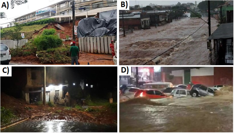
Figure 4
Events occurred in the 2019/2020 rainy season: A. Part of a slope slide on Raja Gabáglía Avenue, in the Western Region of BH ( G1 2020); B. Tereza Cristina Avenue flooding ( R7 2021); C. Street blocked by landslide in the Jardim Teresópolis (Betim) ( Itatiaia 2020); D. Flooding in Barreiro ( Estado de Minas 2020).
Menezes et al. (2021) presented some information regarding risk management and communication in the city of Contagem, in RMBH. By consulting the literature of the region, Menezes et al. (2021) indicated that in rainy periods, areas of flooding are common in the city, especially in the floodplain of Arrudas River and its tributary Ferrugem Stream. In addition, these authors highlighted that the month of January 2020 had a monthly precipitation of 934.7 mm at the Belo Horizonte meteorological station, and more than 200 people were temporarily homeless.
From news reports of various media, especially electronic portals, it can be seen that only in the period between 12/29/2018 and 02/27/2020 there were at least 13 cases of flooding in the RMBH region, and 9 cases of landslides. Such data is usually collected through contact with local residents and/or the press, which makes it difficult to correctly classify and standardize the events that occurred. In Figure 5 we can see the location of the events that were catalogued through the electronic media consulted.
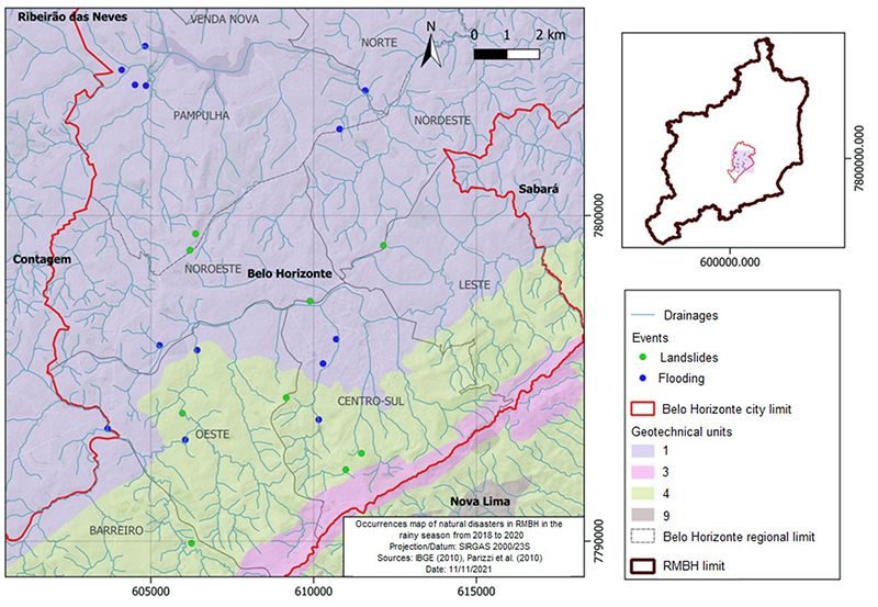
Figure 5
Location of natural disaster occurrences in 2018/2020 rainy season in RMBH.
Figure 6 presents the concentration of human damage in the monitored cities of the RMBH, i.e., the total number of dead, injury and/or sick, homeless, and missing people. It can be seen that the cities with the most people affected were Contagem, Ibirité, Santa Luzia, Jaboticatubas, Mário Campos and Mateus Leme. However, it is worth noting that up to the date of this article, the human damage suffered during the first quarter of 2020 in the municipality of Belo Horizonte had not been calculated, and therefore, the data appear with a total of zero damage in Figure 6.
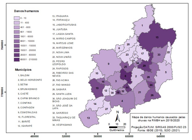
Figure 6
Map of human damage caused by rainfall during the first quarter of 2020 in RMBH ( S2ID 2021).
From January 31, 2020, the Civil Defense bulletins presented a summary of those affected by the rains throughout Minas Gerais. In Figure 7 it is possible to see that the number of those affected decreases dramatically as the rainy season ends.
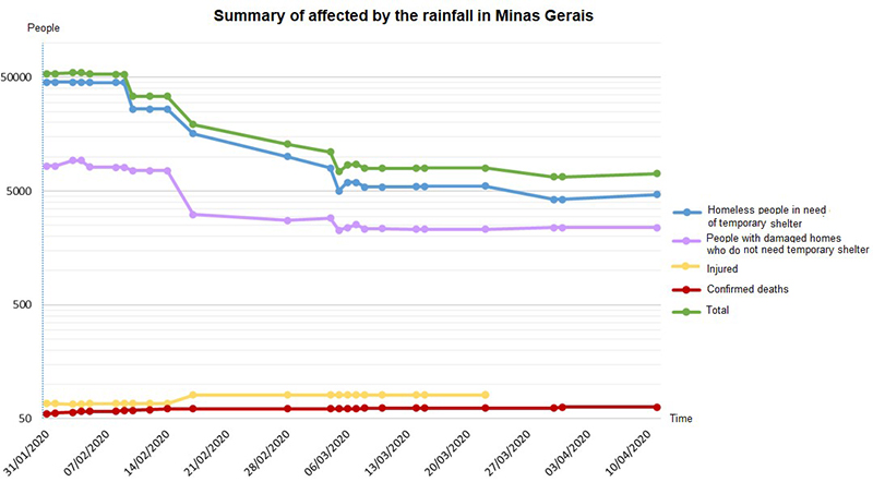
Figure 7
Affected by the rains from 01/31/2020 to 04/10/2020 ( Defesa Civil 2021).
Figure 8 presents the damage in the monitored municipalities of RMBH. Above is presented the amount of homeless, displaced, missing and other people who were directly affected by natural disasters. Below, also in Figures 8A and 8B, the number of dead and injured/injured in the first quarter of 2020 is presented.
Among the total number of people affected in the first quarter of 2020, there were 27 deaths (victims of landslides), 12 of them in Belo Horizonte (Vila Bernadete and Engenho Nogueira); 6 in Betim (Duque de Caxias and Jardim Teresópolis); 5 in Ibirité (Vila Ideal and Durval de Barros); 2 in Contagem (Vila Sapolândia Industrial and Maria da Conceição); 1 in Nova Lima (Cristais); and 1 in Sabará (General Carneiro) ( CEMADEN 2020).
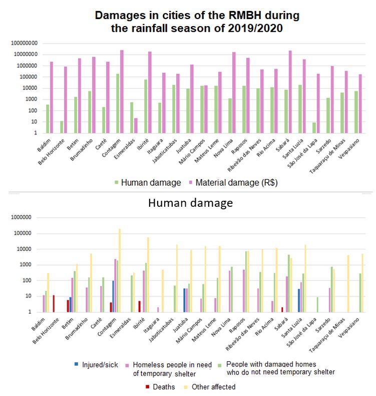
Figure 8
Balance of damage suffered in RMBH cities during the second quarter of the 2019/2020 rainy season: A. Total damage; B. Human damage by category ( S2ID 2021).
Material damage refers to the amount of education, health, commercial or community facilities, housing units or infrastructure damaged or destroyed by the disaster. According to CEMADEN (2020), the significant amounts refer to public infrastructure works (approximately 57%) and damaged or destroyed housing units (approximately 40%). The city with the greatest material damage was the city of Ibirité.
According to CEMADEN (2020), the city of Contagem had the highest number of injured/injured (90), as a result of burial in landslides; and the highest number of homeless (1200), as a result of the evacuation of some communities, such as in Vilas Morro dos Cabritos, Sapolândia Industrial, Itaú, Barraginha, and São Paulo, among others. During the entire rainy season of 2019/2020, the number of 32 deaths (victims of landslides) stands out, 14 in Belo Horizonte alone, 6 in Betim, 6 in Ibirité, 3 in Contagem, 1 in Nova Lima, 1 in Sabará and 1 in the municipality of Esmeraldas. In Figure 9 shows the distribution by municipality of deaths due to rainfall in the RMBH.
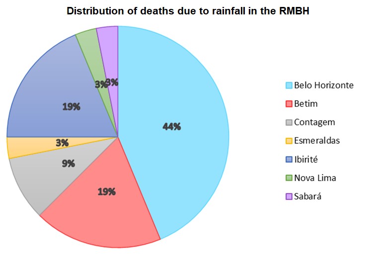
Figure 9
Distribution of rain-related deaths in RMBH ( Defesa Civil 2021).
Thus, it is worth noting the exorbitant number of deaths in RMBH as a result of the impacts generated by ZCAS. Such deaths occurred in a predominantly urban environment and most of them with characteristics of irregular occupation in risk areas. The largest share in total material damage was the public infrastructure works with about 65%, which according to CEMADEN (2020) in a post-disaster context of great magnitude covers a series of interventions of engineering works in space, especially related to the reestablishment of roads in flood events and geotechnical containment of slopes in landslide events.
6 Conclusions
As observed when compiling the data from CEMADEN, IGAM, and the bulletins of the Civil Defense of Minas Gerais, the state faced major challenges of urban character, such as flooding and landslides, due to the rains and their consequences between the months of October 2019 and March 2020. It is worth noting that the cities of Belo Horizonte, Ibirité, and Florestal figured, in the 2019/2020 rainy season, as rainfall record holders and consequently, carry the largest numbers with respect to property damage (Ibirité) and loss of life (Belo Horizonte). Nevertheless, it is important to highlight the significant number of injured, sick, and homeless due to bad weather in the city of Contagem.
RMBH has a vast history of events related to natural disasters and bottlenecks in terms of urban planning. Moreover, the region is characterized by several elements at risk, so the knowledge of the minimum amount of rainfall required for the onset of landslides is extremely important. Thus, the identification of these risk areas is a very important tool to map vulnerable locations and draw up concrete action plans aiming to neutralize the occurrences, strengthen the urban infrastructure of the city and, most importantly, preserve lives.
Because of the lack of a narrow rainfall monitoring network in the study area, characterized by few stations in a relatively large area, the rainfall data used should be used with caution. The need for more stations equipped with rain gauges is well known, since only 12 stations were used for the study, that is, about 1 rain gauge per 800 km². However, Parizzi et al. (2010a) showed that the differences between rainfall rates from region to region are not decisive for the definition of the area most susceptible to landslides, because the areas with lower rainfall rates also reached values of precipitation considered sufficient to trigger these events. Besides this, these authors also emphasize that because the intensity of rainfall varies greatly from one region to another in the same time interval, the real-time reading of the rain gauges is important for the decision making of the competent bodies in each risk area.
Due to the different definitions and methodologies for data collection and availability among the sources analyzed, there is no consensus between the values of damage and losses presented during the rainy season in the RMBH. We emphasize the importance of analyzing all sources with records of events, but one should pay attention to the main limitations of the sources, such as the different levels of quality in filling out the information and in some cases, where only the immediate impacts are recorded after the occurrence of the disaster.
Finally, it is worth highlighting the importance of risk management in metropolitan areas, as is the case of RMBH, for actions involving planning, intervention, and mitigation of natural disasters. As several authors emphasize, among them Parizzi (2014), risk management is a complex social process and it should always involve three distinct phases: before, during, and after the occurrence of events.
7 References
Abreu, M.L. 1998, 'Climatologia da estação chuvosa de Minas Gerais: de Nimer (1977) à zona de convergência do Atlântico Sul', Geonomos, vol. 6, no. 2, pp. 17-22, DOI:10.18285/geonomos.v6i2.166.
Agência Senado 2020, Situação de emergência e estado de calamidade pública, Defesa Civil, Brasil, viewed 12 January 2021, < Agência Senado 2020, Situação de emergência e estado de calamidade pública, Defesa Civil, Brasil, viewed 12 January 2021, https://www12.senado.leg.br/noticias/especiais/especial-cidadania/defesa-civil/situacao-de-emergencia-e-estado-decalamidade-publica>.
Alexandre, G.R., Baptista, M.B & Naghettini, M. 2010, 'Estudo para Identificação de Tendências do Regime Pluvial na Região Metropolitana de Belo Horizonte a Partir de Métodos Estatísticos', Revista Brasileira de Recursos Hídricos, vol. 15, no. 2, pp. 115-26, DOI:10.21168/rbrh.v15n2.p115-126.
Alvarenga, L.A. 2012, 'Precipitação no sudeste brasileiro e sua relação com a ZCAS', Revista Agrogeoambiental, vol. 4, no. 2, pp. 1-7.
Assis, W.L, Parizzi, M.G & Ribeiro, S.M. 2013, 'Identificação dos sistemas atmosféricos responsáveis por inundações e deslizamentos no município de Belo Horizonte: análise dos períodos chuvosos de 2011-2012 e 2012-2013', Revista Geografias, vol. 9, no. 2, pp. 38-55, DOI:10.35699/2237-549X..13360.
Brasil 2012a, Instrução Normativa nº 1, de 24 de agosto de 2012, Diário Oficial da União, Poder Executivo, Brasília, DF 30 ago. 2012, no. 169, seção 1, p. 30.
Brasil 2012b, Anuário brasileiro de desastres naturais: 2011 / Centro Nacional de Gerenciamento de Riscos e Desastres, Ministério da Integração Nacional, Secretaria Nacional de Defesa Civil, Centro Nacional de Gerenciamento de Riscos e Desastres, CENAD, Brasília.
CEMADEN - Centro Nacional de Monitoramento e Alertas de Desastres Naturais 2020, Boletim da Sala de Situação - 1º Trimestre/2020, Centro Nacional de Monitoramento e Alertas de Desastres Naturais, 01 de junho de 2020, Ano 01, n. 01, 71 p, viewed 15 May 2021, < 01, 71 p, viewed 15 May 2021, http://www2.cemaden.gov.br/wp-content/uploads/2020/06/Boletim-da-Sala-de-Situa%c3%a7%c3%a3o-1%c2%ba-Trimestre-de-2020.pdf>.
CEPED-UFSC - Centro de Estudos e Pesquisas em Engenharia e Defesa Civil, Universidade Federal de Santa Catarina 2020, Relatório de danos materiais e prejuízos decorrentes de desastres naturais no Brasil: 1995-2019, 2nd edn, FAPEU, CEPED-UFSC, Florianópolis.
Defesa Civil 2021, Boletim de Defesa Civil do estado de Minas Gerais, viewed 15 May 2021, < Defesa Civil 2021, Boletim de Defesa Civil do estado de Minas Gerais, viewed 15 May 2021, http://www.sistema.defesacivil.mg.gov.br/index.php?modulo=cce&controller=cce&action=boletimsite>.
Dereczynski, C.P., Calado, R.N. & Barros, A.B. 2017, 'Chuvas extremas no município do Rio de Janeiro: histórico a partir do século XIX Extreme Rainfall in The City of Rio de Janeiro: History from the 19th Century', Anuário do Instituto de Geociências, vol. 40, no. 2, pp. 17-30, DOI:10.11137/2017_2_17_30.
Dourado, F., Arraes, T.C. & Silva, M.F. 2012, 'O megadesastre da região serrana do Rio de Janeiro - as causas do evento, os mecanismos dos movimentos de massa e a distribuição espacial dos investimentos de reconstrução no pós-desastre', Anuário do Instituto de Geociências, vol. 35, no. 12, pp. 43-54, DOI:10.11137/2012_2_43_54.
Estado de Minas 2020, Notícias, viewed 26 June 2020, < Estado de Minas 2020, Notícias, viewed 26 June 2020, https://www.em.com.br/app/noticia/gerais/2020/01/15/interna_gerais,1114650/corregos-transbordam-e-bh-tem-recorde-de-vias-bloqueadas.shtml>.
G1 2020, Minas Gerais, viewed 13 June 2020, < G1 2020, Minas Gerais, viewed 13 June 2020, https://g1.globo.com/mg/minas-gerais/noticia/2020/02/11/apos-chuva-recorde-bh-segue-com-varios-deslizamentos-de-encostas.ghtml>.
IBGE - Instituto Brasileiro de Geografia e Estatística 2015, Perfil dos municípios brasileiros, viewed 20 January 2021, < IBGE - Instituto Brasileiro de Geografia e Estatística 2015, Perfil dos municípios brasileiros, viewed 20 January 2021, http://www.ibge.gov.br/home/geociencias/areaterritorial/area.shtm>.
IGAM - Instituto Mineiro de Gestão das Águas 2020, Relatório técnico do período chuvoso 2019-2020, Instituto Mineiro de Gestão das Águas, Relatório Técnico n° 2/IGAM/GMHEC/2020, 26 p, viewed 13 June 2020, < IGAM - Instituto Mineiro de Gestão das Águas 2020,Relatório técnico do período chuvoso 2019-2020, Instituto Mineiro de Gestão das Águas, Relatório Técnico n° 2/IGAM/GMHEC/2020, 26 p, viewed 13 June 2020, http://www.cbhpiranga.org.br/wp-content/uploads/2020/06/Relat%C3%B3rio-Meteorol%C3%B3gico-do-Periodo-chuvoso-2019-2020-Gmhec.Igam-final.pdf>.
Itatiaia 2020, Notícias, viewed 13 June 2020, < Itatiaia 2020, Notícias, viewed 13 June 2020, https://www.itatiaia.com.br/noticia/duas-pessoas-sao-procuradas-em-desabamento-no>.
Jakob, A.A.E. & Young, A.F. 2006, 'O uso do método de interpolação espacial das análises sociodemográficas', Anais doXVEncontro Nacional de Estudos Populacionais, Caxambu-MG: ABEP, pp. 1-22. viewed 2 September 2021, < viewed 2 September 2021, http://www.abep.org.br/publicacoes/index.php/anais/article/viewFile/1530/1494>.
Kobiyama, M., Mendonça, M., Moreno, D.A., Marcelino, I.P.O., Marcelino, E.V., Gonçalves, E.F., Brazetti, L.L.P., Goerl, R.F., Molleri, G.S.F. & Rudorff, F.M. 2006, Prevenção de desastres naturais: conceitos básicos, Organic Trading, Curitiba.
Konrad, C.E. 1997, 'Synoptic-scale features associated with warm season heavy rainfall over the interior southe-astern United States', Weather and Forecasting, vol. 12, no. 3, pp. 557-71.
Kruger, J.E.B. 2012, Capacitação dos gestores de Defesa Civil para uso do Sistema Integrado de Informações sobre Desastres - S2ID, CAD UFSC, Florianópolis.
Lima, K.C., Satyamurty, P. & Fernández, J.P.R. 2010, 'Large-scale atmospheric conditions associated with heavy rainfall episodes in southeast Brasil', Theoretical and Applied Climatology, vol. 101, no. 1-2, pp. 121-35, DOI:10.1007/s00704-009-0207-9.
Lucas, T.P.B., Parizzi, M.G. & Abreu, M.L. 2018, 'Distribuição espacial e densidade por área (km²) do total de registros de impactos hidrometeorológicos ocorridos nas estações chuvosas 2010-11 e 2011-12, em Belo Horizonte-MG', Revista Brasileira de Climatologia, no. 14, pp. 230-251, DOI:10.5380/abclima.v1i0.61030.
Magnago, R.F., Medeiros, P., Raimundo, R.P. & Costa, S.C. 2021, 'Desastres naturais no estado de Santa Catarina - 1998 a 2019', MIX Sustentável, vol. 7, no. 4, pp. 105-14, DOI:10.29183/2447-3073.MIX2021.v7.n4.105-114.
Marcuzzo, F.N, Andrade, L.R. & Melo, D.C.R. 2011, 'Métodos de Interpolação Matemática no Mapeamento de Chuvas do Estado do Mato Grosso (Interpolation Methods in Mathematics of Rainfall Mapping of the State of Mato Grosso)', Revista Brasileira de Geografia Física, vol.4, no. 4, pp. 793-804, DOI:10.26848/rbgf.v4i4.232714.
Menezes, L.O., Parisi, M.G., Ruchkys, Ú.A. & Jardim, A.H. 2021, 'Comunicação em geociências na gestão de riscos e desastres ambientais', Anuário do Instituto de Geociências, vol. 44, 37273, DOI:10.11137/1982-3908_2021_44_37273.
Nunes, A.A. 2018, 'Tendências em eventos extremos de precipitação na Região Metropolitana de Belo Horizonte: detecção, impactos e adaptabilidade', PhD Thesis, Universidade Federal de Minas Gerais, Belo Horizonte.
Parizzi, M.G., Sebastião, C.S., Viana, C.S., Pflueger, M.C., Campos, L.C., Cajazeiro, J.M.D., Tomich, R.S., Guimarães, R.N., Abreu, M.L., Sobreira, F.G. & Reis, R. 2010a, 'Correlações entre chuvas e movimentos de massa no município de Belo Horizonte, MG', Revista Geografias, vol. 6, no. 2, pp. 49-68, DOI:10.35699/2237-549X .13296.
Parizzi, M.G., Moura, A.C.M., Memória, E. & Magalhães, D.M. 2010b, Mapa de unidades geotécnicas da Região Metropolitana de Belo HorizonteRMBH, , Programa Diretor de Desenvolvimento Integrado da RMBH, Relatório de Geoprocessamento.
Parizzi, M.G., Sobreira, F.G., Galvão T.C.B., Aranha. P.R.A., Elmiro, M.A.T. & Beirigo, E.A. 2011, 'Processos de movimentos de massa em Belo Horizonte, MG', Revista Geografias, vol. 7, no. 1, pp. 58-87, DOI:10.35699/2237-549X .13309.
Parizzi, M.G. 2014, 'Desastres naturais e induzidos e o risco urbano', Geonomos, vol. 22, no. 1, pp. 1-9, DOI:10.18285/geonomos.v22i1.288.
Pedro, D.F.P., Freitas, A.C.V. & Belotti, F.M. 2020, 'A influência da Zona de Convergência do Atlântico Sul (ZCAS) na ocorrência de deslizamentos de massa em Belo Horizonte e cidades vizinhas', Revista Brasileira de Climatologia, vol. 27, no. 16, pp. 635-59, DOI:10.5380/abclima.v27i0.70352.
Prieto, R.B. 2016, 'Estudo de eventos extremos de chuva persistente sobre o RS entre 2004 e 2013', Master Thesis, Universidade Federal de Pelotas, Pelotas.
Quadro, M.F.L. 1994, 'Estudo de Episódios de Zona de Convergência do Atlântico Sul (ZCAS) sobre a América do Sul', Master Thesis, Instituto Nacional de Pesquisas Espaciais, São José dos Campos.
R7 2021, Minas Gerais, viewed 2 May 2021, < R7 2021, Minas Gerais, viewed 2 May 2021, https://noticias.r7.com/minas-gerais/avenida-de-bh-volta-a-ser-destruida-pela-chuva-8-meses-apos-reforma-16012021>.
Reis Junior, W. 2016, 'Caracterização das unidades geotécnicas da porção leste da Região Metropolitana de Belo Horizonte, MG', Master Thesis, Universidade Federal de Minas Gerais, Belo Horizonte.
Reis Junior, W. & Parizzi, M.G. 2018, 'Caracterização das unidades geotécnicas da porção leste da Região Metropolitana de Belo Horizonte - MG', Revista Geonomos, vol. 26, no. 2, pp. 23-30, DOI:10.18285/geonomos.v26i2.12565.
S2ID - Sistema Integrado de Informações sobre Desastres 2021, Sistema Integrado de Informações sobre Desastres, viewed 21 May 2021, < S2ID - Sistema Integrado de Informações sobre Desastres 2021, Sistema Integrado de Informações sobre Desastres, viewed 21 May 2021, https://s2id.mi.gov.br/>.
Simões, J.G.G., Jardim, C.H., Parizzi, M.G. & Zanovello, R. 2012, 'Análise do risco de enchentes e inundações na Av. Cristiano machado, Belo Horizonte, MG', Revista Geonorte, vol. 3, no. 8, pp. 867-80, viewed 21 May 2021, < 867-80, viewed 21 May 2021, https://www.periodicos.ufam.edu.br/index.php/revista-geonorte/article/view/2439>.
Silva, L.H.A., Mello, E.V. & Barbosa, D.R. 2012, 'Risco Ambiental de Enchentes nos Rios Formadores da Bacia do Rio Piabanha (Região Serrana Fluminense) Environmental Risk of Flood in Trainers Rivers of River Piabanha Basin (Highlands Fluminense)', Anuário do Instituto de Geociências, vol. 35, no. 2, pp. 78-83, DOI:10.11137/2012_2_78_83.
Stagl, J., Mayr, E., Koch, H., Hattermann, F.F. & Huang, S. 2014, 'Effects of Climate Change on the Hydrological Cycle in Central and Eastern Europe BT - Managing Protected Areas in Central and Eastern Europe', in S. Rannow & M. Neubert (eds), Under climate change, Springer Netherlands, Dordrecht, pp. 31-43.
Teixeira, M.S. 2009, 'Caracterização física e dinâmica de episódios de chuvas intensas nas regiões sul e sudeste do Brasil', PhD Thesis, Instituto Nacional de Pesquisas Espaciais, São José dos Campos.
Vargas Jr., V.R. & Campos, C.R.J., 2015, 'Eventos Severos no Rio Grande do Sul no Período 2004-2008 (Severe Events on Rio Grande do Sul from 2004 to 2008)', Anuário do Instituto de Geociências, vol. 38, no. 1, pp. 137-46, DOI:10.11137/2015_1_137_146.
Xu, H., Taylor, R.G. & Xu, Y., 2011, 'Quantifying uncertainty in the impacts of climate change on river discharge in sub-catchments of the Yangtze and Yellow River Basins, China', Hydrology and Earth System Sciences, vol. 15, no. 1, pp. 333-44, DOI:10.5194/hess-15-333-2011.
Funding information
Data availability statement
Author notes
E-mail: denisefss@yahoo.com.brE-mail:mgparizzi18@gmail.comE-mail:laninhambiental@gmail.comE-mail:gui.ranier@gmail.com
Conflict of interest declaration