Article
Analysis Land Use and Land Cover of the Municipality of Itarema-Ceará-Brazil based on Landsat Multispectral Data
Análise de Uso e Cobertura da Terra do Município de Itarema-Ceará-Brasil com base em Dados Multiespectrais Landsat
 José Nelson do Nascimento josenelsonnascimento@gmail.com
Elenilton Bezerra Uchoa elenilton.uchoa@ifce.edu.br
José Nelson do Nascimento josenelsonnascimento@gmail.com
Elenilton Bezerra Uchoa elenilton.uchoa@ifce.edu.br
Analysis Land Use and Land Cover of the Municipality of Itarema-Ceará-Brazil based on Landsat Multispectral Data
Anuário do Instituto de Geociências, vol. 46, 52684, 2023
Universidade Federal do Rio de Janeiro
Received: 29 May 2022
Accepted: 08 January 2023
Abstract: This work investigated the process of land use and land cover in the municipality of Itarema. It is located in the geographic coordinates of Latitude (S) 2º 55' 13" and Longitude (W) 39º 54' 54” in the northern region of the state of Ceará, with an area of 720.7 km² in the semi-arid region. The objective of this study was to analyze the changes in land use and land cover in the municipality of Itarema for the period from 2000 to 2020, from Landsat 5 and 8 series orbital remote sensing data to evaluate the evolutionary behavior of the landscape. The methodology used was the literary review in (Leite & Rosa 2012) and IBGE Land Use Technician Manual (2013). Technical procedures related to orbital images from the Landsat 5 and 8 series recorded respectively 2000 and 2020 were applied. Imaging treatment was performed with preprocessing and spectral bands, B5 - Medium infrared, B4 - Near infrared and B2 - Green was processed for Landsat 5 and B6 - SWIR-1, B5 - Near infrared and B4 - Red for Landsat 8 in ENVI 4.3. The classification supervised in the Semi-Automatic Plug-in was performed by the MAX-VER method and seven types of use were considered. The results point to a significant change in the typology of dense vegetation from 52.84% in 2000 to a reduction of 25.71% in 2020, followed by the increase in degraded areas from 7.47% in 2000 to 16.03% in 2020. Final considerations, we highlight the importance of remote sensing in observations of landscape evolution and in the interpretation of the typology of use. We identified significant changes in the classes of degraded areas and dense vegetation, both associated supported by the change in the PIB profile of the municipality.
Keywords: Remote Sensing, Semiarid, Landscape.
Resumo: Este trabalho investigou o processo de uso e cobertura da terra no município de Itarema. Localizada nas coordenadas geográficas de Latitude (S) 2º 55' 13" e Longitude (W) 39º 54' 54" na região norte do estado do Ceará, com área de 720,7 km² no semiárido. O objetivo deste estudo foi analisar as mudanças no uso e cobertura da terra no município de Itarema no período de 2000 a 2020, a partir de dados de sensoriamento remoto orbital das séries Landsat 5 e 8 para avaliar o comportamento evolutivo da paisagem. A metodologia utilizada foi baseada na revisão literária em (Leite & Rosa 2012) e Manual Técnico de Uso do Solo do IBGE (2013). Foram aplicados procedimentos técnicos relacionados às imagens orbitais das séries Landsat 5 e 8 registradas respectivamente em 2000 e 2020. O tratamento da imagem foi realizado com pré-processamento das bandas espectrais, B5 - Infravermelho médio, B4 - Infravermelho próximo e B2 - Verde foi processado para Landsat 5 e B6 - SWIR-1, B5 - Infravermelho próximo e B4 - Vermelho para Landsat 8 em ENVI 4.3. A classificação supervisionada no Plug-in Semi-Automático foi realizado considerando o método MAX-VER e estabeleceu-se sete tipos de uso. Os resultados apontam para uma mudança significativa na tipologia da vegetação densa de 52,84% em 2000 para uma redução de 25,71% em 2020, seguida do aumento das áreas degradadas de 7,47% em 2000 para 16,03% em 2020. Para as Considerações finais, destacamos a importância do sensoriamento remoto nas observações da evolução da paisagem e na interpretação da tipologia de uso. Identificamos mudanças significativas nas classes de áreas degradadas e vegetação densa, ambas associadas e amparadas pela mudança no perfil do PIB do município.
Palavras-chave: Sensoriamento Remoto, Semiárido, Paisagem.
1 Introduction
Process of land use and occupation by communities modifies the dynamics of semi-arid environments and landscapes. The population distribution of the municipality and its relationship between rural and urban communities, associated with the economic profile, enables a spatial dynamic of the territory, configuring specific spatial processes of use. In benefit of the land is related to several economic processes, among them, vegetable and mineral extractivism, agriculture, industry and the service sector. In this context, land becomes an object of political, economic and social interest, and is valued in view of its socio-environmental characteristics.
Occupation of the land emerged from the dynamics of the region itself, given the relationship between traditional "Tremembé" peoples and the Europeans in their journey up the coast under the continent. A relevant aspect is about the origin of the name “Itarema”, which in Tupi means “stone of unpleasant smell” according to IBGE (2022c). According to Soares, Medeiros and Albuquerque (2014) the use and occupation of land in Itarema is characterized by the subsistence culture of beans, corn, cassava, monoculture cotton, sugarcane, cashew nuts and various fruits, especially coconut. In the coastal watershed, where the municipality of Itarema is inserted, the way of appropriation of the landscape by society occurs with the use of extractive agropastoral practices, inherited by the first inhabitants of the area, suggesting its influence on land appropriation processes (Kelting 2009).
Discuss Roque, Riegel and Quevedo (2017) the expression "use of soil" can be understood as the way in which space is being occupied by man, whether for the housing, industrial, cultivation or deforested area character. It is understood that the analyses of the types of use of landscapes are related to the need to know the spatial organization of geographical phenomena. For Leite and Rosa (2012), knowledge and monitoring of land use and occupation is paramount for understanding the patterns of space organization, once its trends can be analyzed. Thus, it validates the importance of analyzing the spatial behavior of landscapes through remote sensing techniques as a crucial factor in the process of territorial organization.
The use of images in the process of mapping land use have a great potential for applicability in the environmental theme, the products obtained through remote sensing technology, describe (Augusto 2016), such as radar images and multispectral images of the optical region, have been extremely used in recent years. In this aspect it is worth mentioning the Landsat series, which since the 1970s provides data for various studies such as agricultural, environmental and agricultural science. Suggests Rodrigues, Meireles and Oliveira (2021), remote sensing is a technique that allows the extracting of information through the use of satellite images. Such techniques can be used in several applications, such as the development of maps of land use and occupation, determination of vegetation indices (Normalized Difference Vegetation Index-NDVI, Enhanced Vegetation Index - EVI, Soil-adjusted Vegetation Index-SAVI and Resistance to Atmosphere in the Visible Region-VARI), environmental zoning, and mapping of water resources, planning and management of watersheds.
According to Antunes et al. (2017), information on the identification and characterization of land use and land cover history in deforested areas is necessary to verify the main factors responsible for the occurrence of this phenomenon and to evaluate the environmental implications. In summary, this record is the heritage of landscape changes through the insertion of human activities over time and space, which can be identified through satellites. Points out Brito, Rosa and Silva (2017) the use of satellite images constitute a very reliable and economically viable alternative for monitoring pastures cultivated in Brazil apud (Ferreira et al. 2013; Meneses & Sano 2012). Thus, to allow knowing the nuances existing in the land cover, there are the orbital images of the Landsat series 5 and 8, since it has a high relevance in the process of identification of the types of use in relation to land cover such as forestry and agrarian engineering practices.
Thus, corroborating the thought of Leite and Rosa (2012) use, occupation and land cover can be synthesized through maps. These indicate the spatial distribution of the typologies of anthropic action that may be by homogeneous patterns. In this respect, remote sensing is an important auxiliary tool and essential to carry out spatial mapping processes. Ribeiro, Barros and Lima (2019) see that remote sensing is an indispensable tool with regard to the view of the earth's surface, satellite images allow the extraction of information with precision in relation to the use and cover of the ground.
Medeiros, Alves and Silva (2019) describes that through the digital processing of satellite images, which provided an ease in obtaining and manipulating matrix data that prove possible degradation and increase of urban areas. The technical and operational knowledge of the GIS is relevant to adequately visualize spatial analysis. The objective of this study was to analyze the spatial changes resulting from the process of land use and occupation in the municipality of Itarema-CE in the period from 2000 to 2020, through remote orbital sensing data of the Landsat 5 and 8 series to verify the evolutionary behavior of the landscape through the mapping performed.
2 Methodology and Data
For this research, bibliographic research was initially carried out based on (Kelting 2009), (Leite & Rosa 2012), IBGE Land Use Technician Manual (2013), IPECE (2017), and IBGE (2022a). We opted for such references due to the technical-scientific contribution of the theme. These literary bases subsidize the interpretation of the landscape from the space-time modification of the series under analysis from 2000 to 2020. The method used consists of systemic analysis of the landscape.
2.1 Location of the Study Area
The municipality of Itarema is located between the geographic coordinates of latitude (S) 2º 55' 13" and longitude (W) 39º 54' 54", positioned north of the State of Ceará (Figure 1). It has a territorial area of 720.7 km², with an average altitude of 20 m. It is located in the administrative region of the north coast second IPECE (2017).
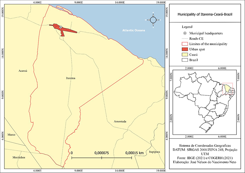
Figure 1
Spatial location of the Municipality of Itarema - Ceará.
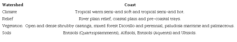
Among its natural characteristics, its inclusion in the semi-arid environment according to resolution N°. 115 of november 23, 2017 and N°. 107 of july 27, 2017 of (SUDENE 2017). In addition to this natural condition, the general characteristics of the environment are presented below Table 1.
It is observed that among one of the economic characteristics the insertion of the coconut production industry in the region influenced the demographic and landscape alteration according to (Cavalcante 2016).
2.2 Operational Technical Procedures
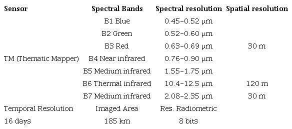
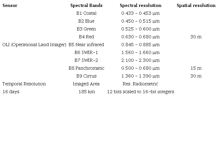
Data were obtained from consultations of Landsat 5/TM (Thematic Mapper) and 8/OLI (Operational Land Imager) in the 20-year time horizon for the operational procedure of the study. Access was linked to the Earth Explorer - USGS (United States Geological Survey) website and the image catalogue were consulted through Landsat Collection 1. Filters were used to choose scenes with a percentage of clouds below 30%. The scenes collected were from the dry season, from august to the 2000 scene and september for the 2020 scene. It is a scene filtering to choose images with a lower probability of finding clouds in the area, for the analyzed period, considering the dry and rainy seasons.
The pre-processing of images consisted of the projection to the coordinate system for SIRGAS 2000/UTM 24S, being the orbit/point of the bands that record the scenes, (Path 218 and Row 62). For composition RGB (Red, Green, and Blue) was produced in the software ENVI 4.5, where it was for the scene 2000, Landsat 5-TM the RGB 542. And for scene 2020, Landsat 8-OLI employed the RGB 654. In thus is, RGB’s were used to verify the false color composition, where the RGB 542 was considered to better reflect the vegetation in relation to the RGB 654 that reflects the targets exposed soil and water bodies better.
Thus, the choice of the following RGB 542 and 654 compositions was chosen due to the spectral signature of the targets mapped by the Landsat 8-OLI and 5-TM satellites. The bands RGB 542 represent B5 Medium infrared, B4 Near infrared and B2 Green; and RGB 654: B6 SWIR-1, B5 Near infrared and B4 Red based on the spectral signature of the targets (soil, water, rock and different vegetation types) and on the analysis of the Landsat 5 and 8 bands we chose these RGB. The responses of the RGB's produced were respectively directed to the supervised classification. It is noteworthy that RGB 542 refers to Landsat 5-MT and RGB 654 to Landsat 8-OLI, both with different configurations and different responses from reflected targets.
Processing of data and spatial information was made on Geographic Information System (GIS) open source QGIS 3.16 software. The image clipping was processed with the overlap between the vector layer (polygonal of the municipality of Itarema) on the raster base of scenes RGB 542 and RGB 654 of Landsat 5 and 8, of spatial resolution of 30 m. In Tables 2 and 3, features about the Landsat 5 and 8 series are shown.
The supervised classification of land use and land cover was based on the method corresponding to MAX-VER (Maximum-Likelihood) and (Meneses & Sano 2012) pixel by pixel, aiming to order the reading of the image to the operational algorithm of the technique of classification by typology of the form ordering in class types, of which it was decided to identify seven typologies. The IBGE Technical Manual of Land Use (IBGE 2013) was used as support.
The classifier used is inserted in the SCP tool - Semi-Automatic Classification Plug-in, where a category of classes was created to interpret the reading of the RGB image of the scenes (2000 and 2020), later classified the RGB of the scenes by the categories identified: urban area, dunes/sand, water, dense vegetation, open vegetation, exposed soil and degraded area.
Visual color adjustment consists of contrast enhancement of products generated from the handling of the histogram of images. Followed by the adequacy of the mapping scale of 1: 15.000, to represent the maps of use and ground cover of the scenes 2000 and 2020 to understand the evolution of the landscape by the typology of use of the form.
The methodological procedure shown in Figure 2 consists in the conception of the central idea of the map to be represented followed by the operational dynamics of decision-making, before the following steps: orbital image acquisition, orbital image reprojection, digital processing, and classification by MAX-VER method and having as final product the map of use and soil cover.
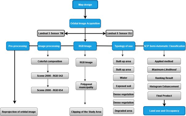
Figure 2
Methodological flowchart of land use municipality of Itarema-CE.
For the measurement of the sample data, the IBGE data source (2000 and 2021) of the population registered and estimated was taken into account. And for the gross national product - GNP of the municipality, IBGE data (2000 and 2019) were considered. The statistical basis applied consists of considering the sample value, applying the subdivision between the groups to know the percentage relationship, being Percentage Value = n (variable) *100/Total. It is worth mentioning that in this study, the site check-list in of the assigned typologies was not performed.
3 Results and Discussion
The description of Table 4 below allows us to understand that the process of land use and occupation in Itarema has its own dynamics. It was observed at the first moment that the rural population remained superior in relation to the urban population, even if there was an increase of its general population, so we can predispose and indicate that land use with activities related to extractivism responds to the analyses of the data presented in Table 4, which indicates that the degradation process of the area doubled in the period verified.
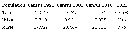
Source: IPECE (2017) and IBGE (2022b). Legend: N/o = No information.
It was verified according to Table 4, that there was a change in the resident population, from 25.548 inhabitants of the IBGE census (1991), to 42.595 inhabitants according to estimated IBGE data (2021), representing a difference of 17.047 inhabitants, 40.02% over three decades. Subsequently, it is estimated that this demographic evolution alters the behavior of the typology of the form of land use and cover as predispose to the comparison between the maps.
There has been a productive restructuring on the coast of Ceará describes Cavalcante (2015), from the analysis of coconut production in irrigated perimeters. Naturally, it is predisposed that with the arrival of the DUCOCO industry in the region, the migration process to the city was in mass, a situation that did not occur. If we look at Table 4, it is possible to identify that the rural population is dominant in relation to the urban population throughout the period.
To understand how the landscape has changed over time, in the analyzed period it is essential not only to identify the typologies mapped to support the discussions, but to understand how the types of use are different and how they will influenced the process of occupation of the areas, and how the mapped salvos behave over time and space.
In scenario 1 and 2, which represents the year 2000 and 2020 respectively, it is observed through the mapping of the areas, that all classes have undergone changes, in fact the growth of typologies, open vegetation, exposed soil and degrades and urbanization areas are mostly activities related to the social and economic aspect, therefore alteration in the territory.
Unlike the typological aspect of the water and dune classes where both have undergone changes but specifically linked to how the saved are reflected in relation to the mapped period. In addition, being directly influenced by the environmental behavior of the territory, the semi-aridity with high rates of potential evapotranspiration ends up interfering in the reading of the targets. However, it is important to mention that the coast of Ceará in recent years has been receiving a very large flow of tourism that induces the urban growth of the municipality.
It's possible verify in Figure 3 the behavior of the typology of the form of land use and occupation of the municipality of Itarema-CE for the recording of the scene of the year 2000, for the Landsat 5-TM image classification.
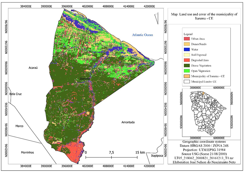
Figure 3
Land Use and Coverage Map of the Municipality of Itarema-CE by Landsat 5 in 2000.
Based on the map of land use and occupation, it is verified that the dynamics of the landscape began to change as population density was distributed among the environments, the existence of specific processes such as extractivism and agriculture has its roots in traditional habits, such as indigenous ones.
In the map shown in Figure 3 seven typologies were identified for scene 21/08/2000 of the Landsat 5 TM sensor series. The remote sensing procedure took into account the socio-environmental context of the coastal semi-arid environment, and was based on the IBGE technical manual (2013).
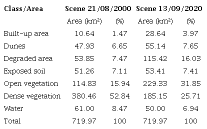
Comparing the two maps to understand the evolutionary behavior of the landscape, it should be noted that scene 1 presents degraded areas with 7.47%, as well as areas of exposed soils with 7.11% well spatialized different from the degraded areas that end up concentrating on nuclei, the justification of this behavior begins with the purposes of use that are related to extractive practices and activities such as subsistence agriculture.
It was observed through scene 2 and the systematized data in Table 3, that the landscape alteration was very significant, where the degraded area jumped to 16.03% and the exposed soil area grew 0.30%. The two mapped classes show, respectively, that the occupation process has been influencing the evolutionary behavior of the landscape that is associated with the extraction of native vegetation to caatinga for various purposes, such as serving needy families in rural communities. Figure 4 represents the scene (Landsat-8) of 2020, in the municipality of Itarema.
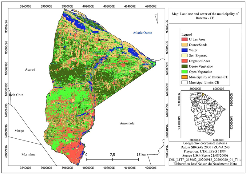
Figure 4
Land Use and Coverage Map of the Municipality of Itarema-CE by Landsat 8 in 2020.
On the other hand, we have that in the process of occupation of dune areas a growth linked to tourism, resulting from the emergence of ecotourism practices and extreme sports that has intensified the types of use on the coast of Ceará, which increased to an increase of 1.0% compared to the scenes recorded for the period 2000 to 2020.
It is worth mentioning that the class change reflects directly in the landscape, and indicates processes of various uses and occupation specific to the territory. These factors are dynamic and are linked to the socioeconomic and environmental context of the municipality, so the interpretation of the identified mapped targets are directly related to the understanding of landscape change.
The types of uses of the territory indicate processes of occupation of different areas, The scenario represented in Figure 4, predispose the reduction of areas of dense vegetation that reached 27.13% is a very large area and covers strategic spaces for the caatinga. On the other hand, the water in turn indicates a reduction of 1.53% when comparing the two mapped scenes. This specific situation may be associated with the reading period of the mapped target, the dry season usually begins in June and runs until the end of december, in turn the semi-arid climate varies between 6 to 7 months, a situation that indicates a reduction in water bodies due to the evapotranspiration of rivers and lakes. Thus, Table 5 below presents the data measured for the recorded images.
The variation of the vegetation cover identified in scene 2 shows the complexity of the coastal vegetation of Ceará, for Moro et al. (2015) its flora is typically composed of species of the surrounding phytogeographic domains (Savanna, Caatinga and Atlantic Forest), added to typical species of beach vegetation (Sandbanks). Thus, the importance of the analysis presented here and how the saved ones behave in relation to the types of uses, which allows us to affirm that the economic aspect is fundamental in the interpretation of the landscape.
The 2020 scene, observed ad the Landsat 8 OLI sensor, indicates a greater expansion of the area related to the exposed soil. These classes are represented between scenes 2000 and 2020 in Table 5 below.
There was a change in landscape behavior as recorded in the usage classes. The typology observed via remote sensing procedure was based on the recording of physiognomic behavior recorded in august and september in scenes 2000 and 2020, situating the dry season of the state of Ceará and can be observed as shown in Figure 5 below.
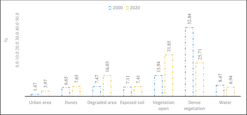
Figure 5
Spatial distribution of land use and occupation data scenes 2000-2020.
The blue bar represents scene 2000 and the yellow bar the 2020 scene. In the dense vegetation class, it was recorded 52.84% in 2000 compared to 25.71% in 2020. It is suggested that the strong reduction in this class is due to the evolution of secondary activities presented in Figure 5. For the open vegetation class, 2000 represented 15.94% while 2020 increased to 31.85%. In coastal environments, suggests Moro et al. (2015) the threats to conservation are more intense. The intense modification observed in the products corroborates the great occupation that occurs along the coastal regions in our country.
The classes of exposed soil and degraded areas together reached about 23.44% of altered areas in the 2020 record. In the degraded area class, 7.47% was observed in 2000 and 16.03% in 2020, with growth in physiognomic alteration. For the exposed soil, the records are 7.11% in the 2000 scene and 7.41 in 2020. The exposed soil class does not alter its physiognomic behavior because it is a natural condition of the landscape, something that is common in the semi-arid climate.
Based on Table 4 and associating it with Table 6, it is identified that the economic growth of the study area probably itemized the change in land cover, as suggested by Table 5 that describes the relationship between classes of use and occupation of land for different periods over two decades.
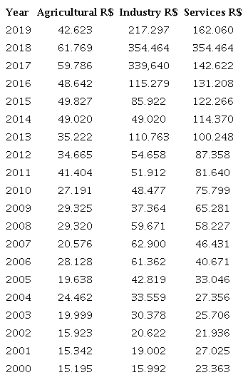
The population distribution of Itarema, in 30.347 inhabitants for the IBGE census (2000), is subdivided into about 20.446 inhabitants 67.37% living in the rural area in relation to 9.901 inhabitants 32.62% located in the urban area. Given the absence of the 2020 census record, we considered the estimated data of the population of 2021 with about 45.595 inhabitants according to (IBGE 2022b). Unfortunately, we do not have the data related to the distribution of the population by zone, which makes it difficult to better understand the process of land occupation. For analysis and understanding of the landscape, the dynamics of the municipality's GDP according to Table 6 below were taken into account.
Source: IBGE (2019).
The data presented in Table 5, although it did not take into account inflation over two decades, allows us to correlate the existence of economic dynamics between the sectors of the economy, where the primary, this situation interferes in the relationship of land use and occupation for the types of economic activities existing in the municipality. Where extractivism still persists and the services sector linked to tourism has grown in recent decades.
The socioeconomic profile of the municipality represented in PIB indicates a change in the typology of land use, corroborating what was presented in the maps of use and occupation. Table 6 shows a price variation between the various sectors, in order to induce a spatial and economic dynamics of the territory. In this analysis, there was a reduction in the agricultural sector from 2000 to 2019, from 27.85% in 2000 to 10.10% in 2019, with a variation of 17.75% between two decades. However, this reduction does not represent a decrease in degraded areas, which is assumed that there was a greater diversification of occupied and degraded areas respectively.
The services data represented indicate a percentage change over the reporting period, from 42.82% in 2000 to 38.40% in 2019, a reduction in the sector, however, with an increase in the price acquired over time and space from R$ 23.363 to R$ 162.060. This economic dynamic of the municipality is a reflection of the temporal variation of inflation in the observed period. The economic indicators considered are the IPCA and its two variables, i) inflation in relation to the year and ii) inflation in relation to 12 months. Such, data presented in Figure 6 below allow to monitor the actual variation of products in relation to the time series in analysis from 2000 to 2020. According to IBGE (2022a) in general aspects, the IPCA indicator allows measuring the inflation of a set of products and services marketed in retail.
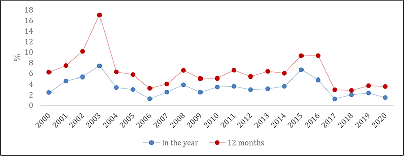
Figure 6
National Consumer Price Index Ample historic series
The indicators of the year 2000 above allows to identify the relationship between 2.48% in the year and 6.23% in relation to 12 months, this means mentioning that the inflation rate was increasing until 2003, when the peak of 7.41% in the year and 17.05% in 12 months was observed. As there is a variation, the final prices available to the consumer tend to rise, which is possible to verify in the tertiary sector at the first moment data from Table 6.
For the other data, it is possible to verify the existence of a variation of 3.41% in the year and 6.28% in 12 months for the year 2004, compared to 2020, there was 1.51% in the year and 3.61% in 12 months, indicating a sum of 9.89% for the year and 4.92% in relation to 12 months. These indicators allow us to affirm that the variation in PIB in Table 6 is understandable in relation to the primary, secondary and tertiary sectors.
The correlation between Table 6 and Figure 6 indicates that there was a real variation in the accumulation of municipal PIB for the secondary and tertiary sectors. This contextualization indicates that the inflation variation over the 12 months, are more unstable in relation to the variation per year. Thus, the reason is justified that the tertiary sector has the highest price accumulation in the market, and the primary sector has relatively lost strength in its economic participation compared to 2000 over 2020.
It is worth mentioning that the primary sector is the one that most alters the behavior of mapped targets and tends to produce more degraded areas and exposed soils, in addition to changing the local dynamics of water, in relation to the behavior of water this is directly related to the period of the year of mapping, usually the months of august and september for the semi-arid climate expose dry river courses due to the high process of evapotranspiration, probably exert strong influence on the change in local hydrological behavior.
The process of land use and occupation, in addition to identifying changes in the areas of the mapped classes, allows contextualizing them to social and economic factors. Reason for indicating the importance of empirical and remote studies. The choice of the time series from 2000 to 2020 and spatial of 1:15.000 km, indicate the burden of landscape behavior of the mapped areas in relation to economic processes of land use, giving light to different studies and with different methodologies.
Studies preliminary using remote sensing performed by (SEMACE 2016) showed the existence of thirteen classes: in addition to the classes represented in this study, are the technogenic alterations, aquaculture/salt pans, sandy sediment, mud texture sediment, anthropized vegetation with culture/reforestation, anthropized vegetation with irregular pattern and ocean, and the largest class with 46.91% of natural vegetation followed by 19.18% in anthropized vegetation was recorded.
The study carried out by SEMACE (2016), which identified the existence of 13 classes, followed a different methodology based on supervised classification with a guided approach via GEOBIA (Geographic Object-Based Imagem Analysis) and IPECE orthophotochart images and Quickbird imagens between the years 2003 and 2010 both provided by SEMACE, and a scale of 1:10.000 was used. However, the study they present was able to identify 7 classes, because we use different methodological base what answers the initial objective of our studying followed the methodology based on supervised classification and on the coding and interpretation of pre-established targets on a scale of 1:15.000.
Correlating to the study, it was observed that the class of dense vegetation showed a change of 27.13%, reflecting the behavior of land use over time, probably due to industrial extractivism with coconut production and for the class of degraded areas it expanded. Around 8.56% in the observed period. Although the two studies describe the same territorial area, the criteria for choosing a class of land use and occupation are different.
In summary, it is suggested that the change of landscape comes from the process of land use reveals the direct influence of culture and social factors in changing the landscape by local communities and appropriation before the historical and cultural aspect of a community of a region. Such analysis was possible through the spatial-temporal reading of the spectral signature of the radiated object and before the interpretations performed came up of the landsat series spatial resolution of 30 m of the pixel that make up the image of the recorded scenes, thus, it is the correlation to the behavior of a type of vegetation cover before an economic, social and political context of use.
Finally, it is suggested that there be a territorial management that takes into account the natural potential and limitations of land use so that permanent preservation areas can be preserved as defined by the current legislation, law n° 12.651 of (Brazil 2012).
4 Conclusion
Remote sensing is consolidated as an important tool for the process of soil use analysis, as it serves as an instrument for the production of information essential to the planning and organization of the territory.
Changes in land use and cover in the municipality of Itarema-CE between 2000 and 2020 were evaluated from Landsat 5 and 8 data. The most modified area corresponds to the dense vegetation class with a variation of 52.84% in (2000) versus 25.71% in (2020). It is inferred that this change can be induced by the economic behavior of the municipality, which ranged from 27.85% in (2000) to 10.10% in (2019) a reason that possibly justifies the degrowth of the agricultural sector. Situation that differs from the reduction in the primary sector since it aggregates several extractive activities.
The significant changes in landscape units were observed in view of the percentage data measured between the scenes via pixel-by-pixel supervised classification. In summary, it was observed that the evolution of the landscape is a change in the landscape is followed by several factors, water availability, edaphic characteristics and population growth, municipality followed by the socioeconomic profile.
It is suggested as possible future research, the use of Sentinel-2 for the analysis of the use of units of permanent preservation areas and areas of integral protection for the study area to monitor the process of economic growth of the municipalities in relation to vulnerable areas. Finally, it is noteworthy that the evolution of the landscapes recorded throughout the analysis period indicated changes in all classes identified.
5 Acknowledgments
To the Federal Institute of Science and Technology of Ceará-IFCE, Campus Sobral.
6 References
Augusto, R.C. 2016, 'A cartografia das paisagens e a perspectiva geossistêmica como subsídios ao planejamento ambiental', Revista Tamoios, vol. 12., no. 1, pp. 114-53, DOI:10.12957/tamoios.2016.22644.
Antunes, J.F.G., Esquerdo, J.C.D.M., Bertollo, L.S., Parizzi, T.N.T. & Coutinho, A.C. 2017, 'Dinâmica de uso e cobertura da terra nas microrregiões de Sinos e Alto Teles Pires no Norte Mato-grossense', paper presented to Anais do XVIII Simpósio Brasileiro de Sensoriamento Remoto, 28 a 31 de Maio de 2017, INPE, Santos, São Paulo, viewed 19 December 2022, < 2017, 'Dinâmica de uso e cobertura da terra nas microrregiões de Sinos e Alto Teles Pires no Norte Mato-grossense', paper presented to Anais do XVIII Simpósio Brasileiro de Sensoriamento Remoto, 28 a 31 de Maio de 2017, INPE, Santos, São Paulo, viewed 19 December 2022, http://marte2.sid.inpe.br/col/sid.inpe.br/marte2/2017/10.27.14.05.11/doc/thisInformationItemHomePage.html>.
Brazil 2012, Lei n° 12.651, de 25 de maio de 2012, Dispõem sobre a proteção da vegetação nativa, 191° da Independência e 124° da República, Brasília, viewed 19 December 2022, <651, de 25 de maio de 2012, Dispõem sobre a proteção da vegetação nativa, 191° da Independência e 124° da República, Brasília, viewed 19 December 2022, https://www.planalto.gov.br/ccivil_03/_ato2011-2014/2012/lei/l12651.htm>.
Brito, J.L.S., Rosa, R. & Silva, M.K.A. 2017, Mapeamento de áreas degradas ocupadas com pastagens no Triângulo Mineiro - MG, INPE, Santos.
Cavalcante, L.V. 2015, 'Os novos espaços da Produção de coco no Ceará: um olhar para os perímetros irrigados', Sociedade e Território, vol. 27, no. I-XXII, pp. 289-308.
Cavalcante, L.V. 2016, 'Os circuitos espaciais da produção de coco no litoral oeste do Ceará', Caminhos de Geografia Uberlândia, vol. 17, no. 57, pp. 41-58, DOI:10.14393/RCG175703.
Ferreira, L.G., Sano, E.E., Fernandez, L. & Araujo, F.M. 2013, 'Características biofísicas e ocorrência de incêndios em pastagens cultivadas na savana brasileira observados por dados de satélite de resolução moderada', Internacional Journal of Remote Sensing, vol. 34, no. 1, pp. 154-67.
IBGE ̶ Instituto Brasileiro de Geografia e Estatística 2013, Manual técnico de uso da terra, 3rd edn, IBGE, Rio de Janeiro.
IBGE ̶ Instituto Brasileiro de Geografia e Estatística 2022a, Índice nacional de preço ao consumidor amplo, IBGE, viewed 24 November 2022, <IBGE ̶ Instituto Brasileiro de Geografia e Estatística 2022a, Índice nacional de preço ao consumidor amplo, IBGE, viewed 24 November 2022, https://www.ibge.gov.br/estatisticas/economicas/precos-e-custos/9256-indice-nacional-de-precos-ao-consumidor-amplo.html?t=o-que-e&utm_source=landing&utm_medium=explica&utm_campaign=inflacao#variacao-mes-grupo>.
IBGE ̶ Instituto Brasileiro de Geografia e Estatística 2022b, Município de Itarema: panorama, IBGE, viewed 21 January 2022, <IBGE ̶ Instituto Brasileiro de Geografia e Estatística 2022b, Município de Itarema: panorama, IBGE, viewed 21 January 2022, https://cidades.ibge.gov.br/brasil/ce/itarema/panorama>.
IBGE ̶ Instituto Brasileiro de Geografia e Estatística 2022c, Município de Itarema: história, IBGE, viewed 7 January 2022, <IBGE ̶ Instituto Brasileiro de Geografia e Estatística 2022c, Município de Itarema: história, IBGE, viewed 7 January 2022, https://cidades.ibge.gov.br/brasil/ce/itarema/historico>.
IPECE ̶ Instituto de Pesquisa e Estratégia Econômica do Ceará 2017, Perfil Municipal 2017 de Itarema, IPECE, Ceará, viewed 21 January 2022, <IPECE ̶ Instituto de Pesquisa e Estratégia Econômica do Ceará 2017, Perfil Municipal 2017 de Itarema, IPECE, Ceará, viewed 21 January 2022, https://www.ipece.ce.gov.br/wp-content/uploads/sites/45/2018/09/Itarema_2017.pdf>.
Kelting, F.M.S. 2009, 'O clima e a paisagem da Bacia Hidrográfica do Litoral-Estado do Ceará', Boletim Goiano de Geografia, vol. 29, no. 2, pp. 83-99, DOI:10.5216/bgg.v29i2.9017.
Leite, E.F. & Rosa, R. 2012, 'Análise de uso, ocupação e cobertura da terra na bacia hidrográfica do Rio Formiga, Tocantins', OBSERVATORIUM: Revista Eletrônica de Geografia, vol. 4, no. 12, pp. 90-102.
Moro, M.F., Macedo, M.B., Moura-fé, M.M., Castro, A.S.F. & Costa, R.C. 2015, 'Vegetação, unidades fitoecológicas e diversidade paisagística do estado do Ceará', Rodriguésia, vol. 66, no. 3, pp. 717-43, DOI:10.1590/2175-7860201566305.
Medeiros, R.B., Alves, L.B. & Silva, C.A. 2019, 'O uso e cobertura da terra: uma análise multitemporal da bacia hidrográfica do Córrego Anhumas, Bonito/MS', paper presented to Anais do XVIII Simpósio Brasileiro de Geografia Física Aplicada 11 a 15 de Junho.
Meneses, P.R. & Sano, E.E. 2012, 'Classificação pixel a pixel de imagens', in P.R. Meneses & T. Almeida (orgs), Introdução ao Processamento de Imagens de Sensoriamento Remoto, Universidade de Brasília, Brasília, pp. 191-206.
Rodrigues, L.G., Meireles, A.C.M. & Oliveira, C.W. 2021, 'Emprego do sensoriamento remoto para análise do uso e ocupação do solo no perímetro irrigado várzeas de Sousa-PB', Irriga, vol. 1, no. 4, pp. 722-9, DOI:10.15809/irriga.2021v1n4p722-729.
Roque, D.C., Riegel, R.P. & Quevedo, D.M. 2017, 'Geotecnologias: Metodologia para mapeamento do uso e ocupação do solo', paper presented to Anais do IX Seminário de Engenharia Geotécnica do Rio Grande do Sul, 27 e 28 de Abril.
Ribeiro, J.K., Barros, R.O. & Lima, E.C. 2019, 'Uso e ocupação do solo através de técnicas de geoprocessamento na cidade de Sobral-CE', Revista da Casa da Geografia de Sobral, vol. 21, no. 2, pp. 540-9, DOI:10.35701/rcgs.v21n2.594.
SEMACE ̶ Superintendência Estadual do Meio Ambiente 2016, Relatório final de mapeamento de uso e cobertura do solo: reestruração e atualização do mapeamento do projeto zoneamento ecológico-econômico do Ceará-Zona costeira e unidades de conservação costeira, SEMACE, Fortaleza.
Soares, V.L., Medeiros, C.N. & Albuquerque, E.L.S. 2014, 'Geoprocessamento aplicado ao mapeamento das formas de uso e ocupação da terra no município de Itarema, Ceará', paper presented to Anais VI Congreso Iberoamericano de Estudios Territoriales y Ambientales, 8 a 12 de setembro, São Paulo.
SUDENE ̶ Superintendência do Desenvolvimento do Nordeste 2017, Resolução n°107 de 2017, Estabelece critérios técnicos e científicos para delimitação do Semiárido Brasileiro e procedimentos para revisão de sua abrangência, Ministério do Desenvolvimento Regional, Recife, viewed 22 September 2022, <SUDENE ̶ Superintendência do Desenvolvimento do Nordeste 2017, Resolução n°107 de 2017, Estabelece critérios técnicos e científicos para delimitação do Semiárido Brasileiro e procedimentos para revisão de sua abrangência, Ministério do Desenvolvimento Regional, Recife, viewed 22 September 2022, http://antigo.sudene.gov.br/delimitacao-do-semiarido>.
USGS. Department of the Interior (USGS). Landsat Missions. Viewed. 21 January 2022(a). Disponível em: <Disponível em:https://www.usgs.gov/landsat-missions/landsat-5>
USGS. Department of the Interior (USGS). Landsat Missions. Viewed. 21 January 2022(b). Disponível em: <Disponível em:https://www.usgs.gov/landsat-missions/landsat-8>
Data availability statement
Funding information
Author notes
E-mail: josenelsonnascimento@gmail.comE-mail: elenilton.uchoa@ifce.edu.br
Conflict of interest declaration