Article
Oil Seep Detection Using Microwave Remote Sensing at Espírito Santo Basin, Eastern Brazil
Detecção de Exsudações de Óleo Usando Sensoriamento Remoto de Micro-ondas na Bacia do Espírito Santo, Leste do Brasil
 Lucas dos Anjos Correa do Espirito Santo lucasanjosesanto@gmail.com
Marcelo dos Santos Salomão salomao.mss@gmail.com
Enrico Campos Pedroso e_pedroso@hotmail.com
Ciro Jorge Appi cjappi@gmail.com
Lucas dos Anjos Correa do Espirito Santo lucasanjosesanto@gmail.com
Marcelo dos Santos Salomão salomao.mss@gmail.com
Enrico Campos Pedroso e_pedroso@hotmail.com
Ciro Jorge Appi cjappi@gmail.com
Oil Seep Detection Using Microwave Remote Sensing at Espírito Santo Basin, Eastern Brazil
Anuário do Instituto de Geociências, vol. 46, 48346, 2023
Universidade Federal do Rio de Janeiro
Received: 30 November 2021
Accepted: 11 May 2022
Funding
Funding source: CAPES
Contract number: 88882.450564/2019-01
Funding statement: This research was funded by the Coordenação de Aperfeiçoamento de Pessoal de Nível Superior (CAPES - grant 88882.450564/2019-01).
Abstract: Hydrocarbon seepage phenomena can be found in most petroleum provinces located in both coastal and ocean regions. The present work aims to identify, map and quantify oil seep candidates in the maritime portion of the Espírito Santo Sedimentary Basin using Synthetic Aperture Radar imagery from Radarsat-2 and Sentinel-1. The selection of the SAR images was made based on their basin coverage area. Meteorological and oceanographic data, when available, were used to assist interpretation. Later, the presence of structures that may enable fluids to escape (faults, fractures, salt domes, etc.) was verified in 101 seismic lines. After detailed analysis, the obtained data were gathered, aiming to classify the oil seep candidates found according to their probability of happening. There were 3 parameters, subdivided into criteria, used in the ranking score: SAR (distance of vessels, number nearby possible seeps and feature size), Geological (morphotectonic domains) and Seismic (distance from seismic lines, presence of structures and distance from structure). Each criterion received grades ranging from 0.1 to 1.0. The final score is given by the arithmetic mean of the parameters. This allowed the seep candidates to be organized in a ranking. The methodology was successful in identifying 54 promising features in the Espírito Santo basin and northern Campos basin. Half of the seep candidates found, 27 features, obtained a grade higher than 0.7, which strengthens the idea of being oil seeps. As an outcome a map was made in 1:3,500,000 scale with the location of all oil seep candidates mapped in this petroleum province.
Keywords: Image processing, SAR, Seismic.
Resumo: Exsudações de hidrocarbonetos podem ser encontrados na maioria das províncias petrolífera localizadas em regiões costeiras e oceânicas. O presente trabalho tem como objetivo identificar, mapear e quantificar potenciais exsudações de óleo na porção marítima da Bacia Sedimentar do Espírito Santo, utilizando imagens dos Radares de Abertura Sintética Radarsat-2 e Sentinel-1. A seleção das imagens SAR foi feita com base na sua área de cobertura da bacia. Dados meteorológicos e oceanográficos, quando disponíveis, foram utilizados para auxiliar a interpretação. Em seguida, a presença de estruturas que possam permitir o escape de fluidos (falhas, fraturas, domos de sal, etc.) foi verificada em 101 linhas sísmicas. Após análise detalhada, os dados obtidos foram integrados, visando a classificação das possíveis exsudações em função da probabilidade de acontecerem. Foram utilizados na pontuação 3 parâmetros, subdivididos em critérios: SAR (distância de embarcações, quantidade de possíveis exsudações próximas e tamanho das feições), Geológicos (domínios morfotectônicos) e Sísmicos (distância das linhas sísmicas, presença de estruturas e distância das estruturas). Cada critério recebeu notas que variam de 0,1 a1,0. A nota final é dada pela média aritmética dos parâmetros, o que permitiu organizá-las em um ranking. A metodologia foi bem-sucedida na identificação de 54 feições promissoras na bacia do Espírito Santo e porção norte da bacia de Campos. Metade das possíveis exsudações encontradas, 27 feições, obtiveram nota superior a 0,7, o que fortalece a ideia de serem exsudações de óleo. Como resultado, um mapa foi confeccionado, na escala de 1:3.500.000, com a localização de todas as possíveis exsudações de óleo mapeadas nesta província petrolífera
Palavras-chave: Processamento de imagens, SAR, Sísmica.
1 Introduction
Understanding basin geology and hydrocarbon migration is key for oil seep detection in marine sedimentary basins. Thrasher et al. (1996) advocate that there is a spectrum of seepage styles, according to basins geological differences. Salt structures and faults, as in the Espírito Santo Basin, can focus migrating petroleum upward to produce point source seeps.
The preferred way to map oil seeps at the sea surface is through Synthetic Aperture Radar (SAR) orbital systems, well documented at the literature (Garcia-Pineda et al. 2013; Garcia-Pineda et al. 2017; MacDonald et al. 2015; Miranda et al. 2004; Pedroso 2009). As active sensors operating at the microwave frequencies of the electromagnetic spectrum, they produce images both day and night (Meneses & Sano 2012), and are less affected by the presence of clouds. The seep identification is possible because oil increases the viscosity of the water surface, hindering the formation of capillary waves (centimetric waves formed by the action of winds). This reduction of the sea surface roughness makes the signal to reflect and not return to the sensor, leaving the image smooth and darker than the surrounding water (Garcia-Pineda et al. 2013; Garcia-Pineda et al. 2017; Genovez, Palmeira & Bentz 2009). Also, for the detection to occur, it is necessary wind field velocities between 2 and 8 m/s (Carvalho 2015; Lima 2008; Miranda et al. 2004; Rebello 2012; Torres 2017).
Not only oil seeps result in dark areas at the sea surface. The so-called look-alike features (such as biological oils, storm clouds, low wind zones, vessels discharge, and others), can cause then as well, leading to an erroneous interpretation. When hydrocarbons reach the surface, it begins to degrade until it disappears (Fingas & Fieldhouse 2012). For this reason, dark features that are observed in the same place through time are indicatives of a seepage activity or a submerged polluting source (rupture of pipes/ shipwrecks) (MacDonald et al. 2015). Illegal discharges from ships, on the other hand, have a more rectilinear pattern (following the direction the vessel sails) and are not observed over time. This type of approach is very useful and accepted in the oil industry, as shown by Miranda et al. (2004) and MacDonald et al. (2015) in the Gulf of Mexico.
Based on these characteristics, this work proposes to map oil seep candidates in the maritime portion of the Espírito Santo Basin, Brazil, using Synthetic Aperture Radar imagery from satellites Sentinel-1 and Radarsat-2. It also aims to rank, according with a proposed SAR, geological and geophysical parameters, the oil seep candidates found from the most to the least likely interesting feature to be suggested for further detailed investigation.
2 Geological Setting
Located in the Brazilian eastern margin, the Espírito Santo basin was formed in the context of the Gondwana supercontinent break-up and the formation of the Atlantic Ocean. It is delimited to the North by the Mucuri Basin and the Abrolhos Volcanic Complex, and to the South by the Campos Basin, through the Vitoria High. The basin comprises an area of approximately 125,000 km2, of which only 18,000 km2 are in the emerged portion and, 107,000 km2 are offshore (Fiduk et al. 2004).
Espírito Santo basin’s tectonic-stratigraphic evolution is interpreted as a passive rift with a N-S axis, including volcanic and sedimentary rocks ranging from the early Cretaceous (Valanginian- Aptian) up to the Neogene (França et al. 2007). The main hydrocarbons source rocks in the basin are the shales from Cricaré Formation, deposited in a lacustrine environment from the rift phase. Source rocks from this age are related to the Pre-Salt, that is responsible for three out of four barrels of oil already discovered in Brazil (Milani & Araújo 2003; Mohriak 2003; 2006).
Tectonic quiescence from the Post-rift phase (Alagoas stage, Aptian) allowed the deposition of the Itaúnas evaporites. Its salt has begun to move in the late Aptian-Lower Albian (Fiduk et al. 2004; Mohriak 2003) and reaches thicknesses from 50 m onshore to more than 5,000 m in deep and ultra-deep waters (França et al. 2007). It deforms and controls sedimentation up to the present, conditioning paleocanyons, trapping turbidites, forming mini-basins (Fiduk et al. 2004; Mohriak 2003), folding the surrounding sediments and providing traps for the oil and gas industry.
Drift phase comprises the rocks deposited from Albian to the present. It can be subdivided into two phases: the Initial Drift (with marine and transgressive sequences, with depositions of sandstones, limestones, shales and turbidites) and the Late Drift (with regressive character, with deposition of shallow carbonate platform and fluvial deposits).
The latest magmatic phase recorded in the basin occurred during the Eocene. The Abrolhos volcanic complex covers an area of 30,000 km2 (França et al. 2007; Fiduk, et al. 2004; Mohriak 2006) being formed by the passage of the Trindade Hot Spot in the northern portion of the Espírito Santo Basin (Mohriak 2006). Magmatic bodies in the sedimentary column increases towards the Abrolhos Plateau and may have locally affected the thermal maturation of the rocks and, consequently, the potential for oil and gas generation.
3 Methodology and Data
3.1 Geological and Geophysical Data
The adopted methodology was followed by extensive bibliographic review, geological and geophysical data acquisition, processing and spatial data analysis (Figure 1). All procedures were done at the Laboratory for Applied Remote Sensing at the Rio de Janeiro State University (LARS-UERJ). Each oil seep candidate mapped was identified by a number (represented in the text by a “#”). At the end, they were classified, weighted (according to criteria that will be discussed later in this paper) and its relative importance calculated.
After the literature review, the first stage of the project consisted in the selection of geological and geophysical data. A total of 21 Radarsat-2 (RS2) scenes, provided by LARS-UERJ, were selected, ranging from January to October of 2010 and 23 Sentinel-1 (ST1) scenes, from September 2019 to May 2020, were downloaded from ESA Copernicus SciHub. Those periods were selected by their data availability. Due to satellite acquisition characteristics, the images occupy different footprints (ST1- smaller, RS2- larger), and sometimes surpasses the limits of the basin, partially encompassing the south of the Mucuri Basin and the north of the Campos Basin.
Image processing steps were employed using PCI Geomatics software, where the images were orthorectified using WGS 84 datum, reprojected by the cubic method (with a 50x50m pixel) and a Frost Filter with 3x3 pixels cell was applied to reduce speckle noise. The resultant product was loaded into the software ESRI/ArcMap version 10.7.1, where potential oil seep features were mapped at each SAR scene. Those features were initially represented by best-fitting ellipses and then by their centroids.
Interpreting ancillary meteorological and oceanographic data allows to reduce the uncertainties regarding the oil seep identification. The sea surface wind speed, the ocean colour (Chlorophyll Concentration) and the sea surface temperature datasets, when available, were applied to assist the interpretation of the dark features. Those data were obtained directly from the SAR images, MODIS and Sentinel-3 optical sensors.
After that, in order to verify the presence of structures (e.g., faults, fractures, etc.) that reach the seabed and might be associated with fluid scape, two 2D seismic surveys were requested at the National Agency for Oil, Natural Gas and Biofuels - ANP repository. The analysis of the seismic lines was initially performed on the IHS Markit Kingdom software, but due to the limitations caused by the Covid-19 pandemic, some had to be done on OpendTect version 6.6.
In a way to help the identification of discontinuities (faults and fractures), the Amplitudes Volume Technique (Tecva), also called Pseudo Relief, proposed by Bulhões and Amorim (2005), was applied. This technique increases seismic contrasts, making the seismic section resemble real outcrops and allowing a better visualization of geological features.

Figure 1
Flowchart that shows the adopted Methodology steps.
3.2 Spatial Data Analysis
In this final stage, all data were integrated to quantify and rank the mapped oil seep candidates. In order to rank them, from the most to the least likely, scores were assigned, between 0.1 and 1 (respectively the worst and the best scenario). The final ranking score were calculated by the arithmetic mean between SAR, Geological and Seismic parameters. Table 1 summarizes the parameters and its equivalent scores.
The scores related to SAR parameters were based on the following three criteria, and its final grade is the arithmetic mean between then:
(1) The proximity of dark features with vessels (ships, platforms, etc.), recognized as bright spots on SAR images, may indicate that they are look-alike features from anthropic origin. Through the multiple rings buffers with radius ranging from 1 km to 50 km, made for each image, 5 categories (1, 5, 10, 25, 50 km) were defined. The greater the distance from a feature to vessels, the more plausible it is to be an oil seep;
(2) Oil seep features may occur over time, near or in the exact place where they were identified, while other natural and anthropic phenomena tend not to repeat. However, depending on the conditions at the time of acquisition, oil seeps may exist, but do not appear on all images. Therefore, to increase the accuracy of the interpretation, a greater number of SAR images are required and the proximity between each feature found should ideally be small. Hence, 5 categories were defined for weight distribution, based on the quantity of nearby possible seeps within a 50 km radius from each seep candidate. As a result, there were some seep candidates that had 19 seeps nearby, while others had none. With smaller radius, the number of nearby possible seeps also decreases; and
(3) Extraction of the dark features was made by best-fit ellipses, which allowed to estimate its areas and axes. Elongated features and those with very large areas usually have anthropic origin or reflect meteorological, oceanographic or biological aspects. Thus, it was considered ideal that the ratio between the major and the minor axes should be inferior than 5. In the same way, it was stated that areas smaller than 2 km2 or greater than 20 km2 should be penalized, as they tend to reflect look-alikes rather than oil seeps.
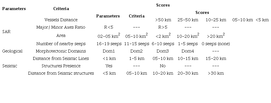
Through the assimilation of the bibliography with the seismic data, it was possible to extract major tectonic lineaments such as the COB (Continent-Ocean Boundary) and Hinge line, presence of volcanic rocks and main salt related morphotectonic domains present in the basin. Such domains may be more or less prone to seepage activity, receiving weights accordingly (Table 2). It is important that the features are located in continental crust, that is, between the Hinge line and the COB, since it is among these markers that the source rocks were deposited.

Derived from the assimilation of seismic and bibliographic data and SAR interpretation, Seismic Score is based on three criteria: (1) Distance to seismic line: defined based on the projection of the seep candidates centroids to the lines that were up to 20 km away from them, that is, the shortest distance between the centroid and the seismic line; (2) Presence of structures: after careful analysis of 101 nearby seismic lines, it was verified if there was any structure that disturbs the seabed and could provide fluid escape, regarding its type (faults, paleochannels, salt domes, etc); and (3) Distance to the nearest structure: for each interpreted line, the horizontal distance from the centroid projection to the nearest structure were verified.
The Seismic partial score is an arithmetic mean of the scores of the 3 criteria per seismic line and represents the grade that the seep candidate received for that line. Since oil seeps are not seen in just one line, the final seismic score is given by the sum of the partial grades divided by the number of lines in which they appear.
4 Results and Discussion
The elongated dark features found with "bright spots" on the tip were interpreted as the trail of a vessel’s passage. Other look-alike features recognized are shadow zones, presence of rain cells, biological oils and formation tests. Such features, as #16, were excluded from the classification calculation. A comparison between a seep candidate (at the top) and a seep look-alike (at the bottom), with anthropic origin, is shown in Figure 2.

Figure 2
Comparison between Seep Candidate #38 and a Seep Look-Alike of anthropic origin.
SAR images analysis provided the identification of 54 seep candidates, with different shapes, sizes and orientations. Ten of them are located in the northern portion of the Campos Basin. The persistence over time, that is, the number of times an oil seep candidate appears and the proximity between the features of one image to another, corroborates to the comprehension that they are oil seeps and not look-alike features (Figure 3).

Figure 3
Map that shows the Oil Seep Candidates #42, #43, #52, #53 proximity and their position in the basin.
The Espírito Santo Basin Oil Seep Candidates Map (Figure 4), originally at 1:3,500,00 scale, presents all the 54 seep candidates’ positions. It is also possible to identify that some of those features are in exploratory blocks/ production fields areas and some are within or near Costa das Algas environmental protection area. This proximity to a marine preservation area, may be more interesting to an ecological investigation, rather than to an exploratory campaign.

Figure 4
Espírito Santo and Northern Campos Basins Oil Seep Candidates Map originally at 1:3,500,00 scale.
The seismic lines analysis allowed the recognition of structures that reaches the seafloor. The main feature responsible for faulting and deforming the sediments, including the seabed, are related to the halokinesis present in the basin. Other faults are associated with canyons and to the continental shelf break and slope. Gas chimneys and some structures similar to pockmarks were also identified.
Disregarding the effects of marine currents, both in depth and on the sea surface, the presence of oil seep candidates just above or near structures strengthens the idea that they serve as pathways through which the fluids escape (Figure 5). Structures that reaches the seafloor but have no seepage activity directly associated suggest that volcanic rocks in the sedimentary column may have oversaturated the hydrocarbons, allowing gas (barely detectable by SAR) to escape, but not oil. Another explanation is that these structures may already be sealed or not be connected to reservoir rocks.

Figure 5
SW-NE Seismic line with salt top (purple) and faults (red lines) interpretation, an the oil seep candidates found (red triangles).
As previously described, each feature received a grade that made it possible to calculate its rank among the others, resulting in Table 3. No oil seep candidate received the highest grade 1, yet, the majority received a score greater than 0.7, attesting that those features have a greater chance of being oil seeps. Confirmation is only possible through in situ verification, collection and chemical analysis.
After detailed investigation, the seep candidate #16 was recognised as a look-alike feature of anthropic origin. Hence, it was not classified in the ranking and neither shown in the final map.
Features near the coast can be the result of anthropic action, as it is a region with more traffic of vessels, or biological action, if high chlorophyll concentration was indicated. The lack of structures in the seismic lines supports the idea that such features are less likely to be an oil seep.

Located outside the study area, in the Campos basin, the oil seep candidates #1, #2, #3, #4, #5, #19, #39 and #40 didn’t receive a seismic score. Therefore, they were classified in the last positions. Despite being in the outer limit of the basin, the oil seep candidates #22 and the #30 are within the radius of 20 km from a seismic line, and so they received a score, being the #30 classified as the least likely of those who were graded.
Although belonging to the Espírito Santo basin, the oil seep candidates #17 and #35, were located at a distance greater than 20 km from the nearest seismic line, so they also didn’t receive a seismic score, and were only better classified than those from the Campos basin.
5 Conclusions
The results presented in this study demonstrated the efficacy of the combination of SAR, meteorological, oceanographic and seismic data to recognize and quantify oil seep candidates in the maritime portion of the Espírito Santo Basin.
The analysis of the multiple SAR images from both Radarsat-2 and Sentinel-1 satellites allowed the identification of several dark features, being interpreted as oil seep candidates and look-alikes. Seismic lines helped to determine the presence of any geological structure that could lead to petroleum seepage process. Look-alike features were discarded, while possible seeps were classified according with a proposed remote sensing, geological, and seismic criteria. Surface and deep marine currents were neglected.
The outcomes of this research are summarized in the map (presented in Figure 4) and in Table 3, containing the location and ranking of all possible oil seeps mapped in the Espírito Santo and Northern Campos Sedimentary Basins. From the 54 mapped oil seep candidates, 10 didn’t receive a score, as they were far from a seismic line, being ranked in the bottom positions. At least 27 features received a score greater than 0.7, which indicates a higher probability of being an oil seep and places for future in situ analysis. By contrast, final scores closer to or below 0.5 (such as #13 and #30) has lower possibilities to be an oil seep.
The remote sensing technology is considered an important and effective method for collecting information over large areas such as in maritime basins. Among then, SAR processing and interpretation provides valuable information and ultimately is considered to be the most suitable methodology for oil seeps detection at the sea surface. From the data obtained, it was possible to identify the most favourable sites for the occurrence of seepage activity. Those areas of major interest are recommended for future prospecting steps in the Espírito Santo basin, through surface geochemistry campaigns and/or acquisition of newer and denser seismic surveys.
6 Acknowledgements
The authors thank ANP for providing the seismic data used for this study, and the Laboratory for Applied Remote Sensing (LARS-UERJ) and PPGG/UERJ for the infrastructure support. We would also like to thanks the Coordenação de Aperfeiçoamento de Pessoal de Nível Superior (CAPES) for the scholarship funding of the first author in UERJ Geoscience Postgraduate Program.
7 References
Bulhões, E. & Amorim, W.N. 2005, 'Princípio da SismoCamada Elementar e sua aplicação à Técnica Volume de Amplitudes (tecVA)', 9th International Congress of the Brazilian Geophysical Society, Salvador, DOI:10.1190/sbgf2005-275.
Carvalho, G. 2015, ' Multivariate data analysis of satellite-derived measurements to distinguish natural from man-made oil slicks on the sea surface of Campeche Bay (Gulf of Mexico) ', PhD thesis, Universidade Federal do Rio de Janeiro.
Fiduk, J., Brush, E., Anderson, L., Gibbs, P. & Rowan, M. 2004, 'Salt Deformation, Magmatism, and Hydrocarbon Prospectivity in the Espirito Santo Basin, Offshore Brazil', in P. Post, D. Olson, K. Lyons, S. Palmes, P. Harrison & N. Rosen, Hydrocarbon Prospectivity Concepts, Applications and Case Studies for the 21st Century, SEPM Society for Sedimentary Geology, pp. 640-68, DOI:10.5724/gcs.04.24.0640.
Fingas, M. & Fieldhouse, B. 2012, 'Studies on water-in-oil products from crude oils and petroleum products, 'Marine Pollution Bulletin, vol. 64, no. 2, pp. 272-83, DOI:10.1016/j.marpolbul.2011.11.019.
França, R., Del Rey, A., Tagliari, C., Brandão, J. & Fontanelli, P. 2007, 'Bacia do Espírito Santo ', Boletim de Geociências da Petrobras, vol. 15, no. 2, pp. 501-9.
Garcia-Pineda, O., MacDonald, I., Hu, C., Svejkovsky, J., Hess, M., Dukhovskoy, D. & Morey, S. 2013, 'Detection of floating oil anomalies from the Deepwater Horizon oil spill with synthetic aperture radar', Oceanography, vol. 26, no. 2, pp. 124-37, DOI:10.5670/oceanog.2013.38.
Garcia-Pineda, O., Holmes, J., Rissing, M., Jones, R., Wobus, C., Svejkovsky, J. & Hess, M. 2017, 'Detection of Oil near Shorelines during the Deepwater Horizon Oil Spill Using Synthetic Aperture Radar (SAR)', Remote Sensing, vol. 9, no. 6, pp. 1-19, DOI:10.3390/rs9060567.
Genovez, P., Palmeira, F. & Bentz, C. 2009, 'Detecção e Monitoramento de Óleo através da Utilização Integrada de Imagens de Satélite, Verificações de Campo e Modelagem de Deriva de Óleo: Uma Abordagem Operacional ', Anais XIV Simpósio Brasileiro de Sensoriamento Remoto, INPE, Natal.
Lima, S.C. 2008, ' Utilização de imagens SAR para a detecção de exsudações de óleo na porção offshore da Bacia de Camamu-Almada (BA), Brasil', Dissertação de Mestrado, Universidade Federal do Rio de Janeiro.
MacDonald, I., Garcia-Pineda, O., Beet, A., Daneshgar Asl, S., Feng, L., Graettinger, G., French-McCay, D., Holmes, J., Hu, C., Huffer, F., Leifer, I., Muller-Karger, F., Solow, A., Silva, M. & Swayze, G. 2015, 'Natural and unnatural oil slicks in the Gulf of Mexico', Journal of Geophysical Research: Oceans, vol. 120, no. 12, pp. 1-17, DOI:10.1002/2015JC011062.
Meneses, P. & Sano, E. 2012, ' Sensor Radar de Abertura Sintética', in P. Meneses & T. Almeida, Introdução ao Processamento de Imagens de Sensoriamento Remoto, UNB, Brasília, pp. 57-76.
Milani, E. & Araújo, L. 2003, ' Cap. X: Recursos Minerais Energéticos: Petróleo ', in L. Bizzi, C. Schobbenhaus, R.M. Vidotti & J.H. Gonçalves (eds), Geologia, Tectônica e Recursos Minerais do Brasil: textos, mapas e SIG, CPRM, Brasília, pp. 541-77.
Miranda, F., Marmol, A., Pedroso, E., Beisl, C., Welgan, P. & Morales, L. 2004, 'Analysis of RADARSAT-1 data for offshore monitoring activities in the Cantarell Complex, Gulf of Mexico, using the unsuérvised semivariogram textural classifier (USTC)', Canadian Journal of Remote Sensing, vol. 30, no. 3, pp. 424-36, DOI:10.5589/m04-019.
Mohriak, W.U. 2003, 'Cap III: Bacias Sedimentares da Margem Continental Brasileira', in L. Bizzi, C. Schobbenhaus, R. Vidotti & J. Gonçalves (eds), Geologia, Tectônica e Recursos Minerais do Brasil: textos, mapas e SIG, CPRM, Brasília , pp. 87-165.
Mohriak, W.U. 2006, 'Interpretação geológica e geofísica da Bacia do Espírito Santo e da região de Abrolhos: petrografia, datação radiométrica e visualização sísmica das rochas vulcânicas', Boletim de Geociências da Petrobras, vol. 14, no. 1, pp. 133-42.
Pedroso, E.C. 2009, 'Ranking de Exsudações de Óleo como suporte à Exploração Petrolífera em Águas Ultra-Profundas: Estudo de Caso no Golfo do México', Tese de Doutorado, Universidade Federal do Rio de Janeiro.
Rebello, V.P. 2012, 'Ranking Fuzzy de Exsudações de Óleo Detectadas com Dados RADARSAT-1 na Bacia de Campos', Dissertação de Mestrado, Universidade Federal do Rio de Janeiro.
Thrasher, J., Fleet, A., Hay, S., Hovland, M. & Düppenbecker, S. 1996, 'Chapter 17: Understanding geology as the key to using seepage in exploration: spectrum of seepage styles', in D. Schumacher & M. Abrams (eds), Hydrocarbon migration and its near-surface expression, American Association of Petroleum Geologists, pp. 223-41, DOI:10.1306/M66606C17.
Torres, S.B. 2017, 'Detecção de Exsudações de Óleo no Complexo de Cantarell (Golfo do México) com Dados SAR Polarimétricos do Satélite RADARSAT-2 ', Dissertação de Mestrado, Universidade Federal do Rio de Janeiro.
Funding information
Data availability statement
Author notes
E-mail:lucasanjosesanto@gmail.comsalomao.mss@gmail.come_pedroso@hotmail.comcjappi@gmail.com
Conflict of interest declaration